

NON-residents of Staten Island may not know that the borough has its very own rail line which, although resembling a subway, isn’t run as a subway at all. Formerly known as Staten Island Rapid Transit, the Staten Island Railway was begun by Cornelius Vanderbilt in 1851 for the purposes of linking Vanderbilt’s Landing in Stapleton to Clifton. By 1860, the line was extended to Eltingville, then on to Annadale, and finally to Tottenville.
In 1883, Erastus Wiman, in partnership with the Baltimore & Ohio Railroad, built a line to South Beach and along the North Shore. By 1885, what would become the SIRT was complete, with the completion of the tunnel between Stapleton and the St. George Ferry. The ferry terminal opened in 1897 (the present-day terminal was constructed in 2005 after a fire destroyed the 1946 terminal, which in turn replaced the original, also destroyed by a blaze). In the 1930s, a Works Progress Administration project eliminated most of the RR’s at-grade crossings, placing them on embankments, trestles and open cuts; these provide speculative views of what would have happened had the Independent Subway built out-of-doors stations. Mid-Staten Island lagged behind, finally eliminating grade crossings by 1965. Only Tottenville line stations are still in use: North Shore and South Shore service ended in 1953. A short stretch of the North Shore branch is still in use as a freight connection between New Jersey and Arlington Yards, operating over the Arthur Kill lift bridge.
By 1953, ridership had dropped to such a degree (due to reduced bus fares) that the B&O threatened to terminate all passenger service. The City agreed to subsidize service on the Tottenville line and terminate service on the North Shore and South Beach branches. The B&O ended its involvement with Staten Island Rapid Transit in 1971, selling it to NYC for $3.5 million. Quaint B&O passenger coaches that had operated on the line since 1925 were replaced by modern R-44 subway cars. Finally, the MTA changed the name of the SIRT in 1994, renaming it the Staten Island Railway. After decades as the last repository for 1970s R44 cars, the SIR has now fully updated to new R211S cars and as such, uses the most modern rolling stock on any NYC rapid transit line.
SIRT North Beach Branch by Gary Owen
SIRT South Beach Branch by Gary Owen
GOOGLE MAP: WALKING THE SIR SOUTH BEACH BRANCH
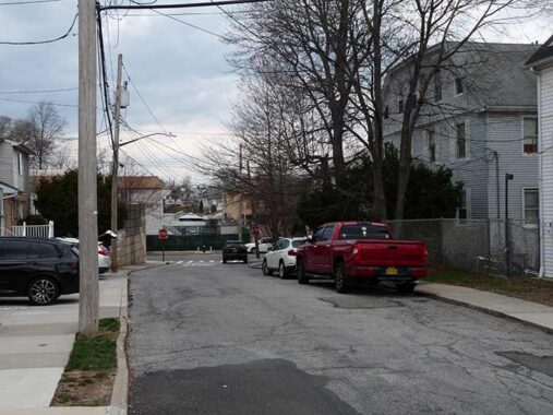
In January and March 2025, I walked the length of Staten Island’s Bay Street from St. George to Fort Wadsworth in two separate trips. To satisfy curiosity, while walking back north to Clifton Station to return to the ferry, I decided to adhere as best I could to the old SIRT South Beach Branch in its stretch between Fingerboard Road and Clifton Station. As I’ve said, most traces of this line have been completely abolished and only some street angles and crumbling remains indicate that a railroad once ran there.
South of Fingerboard Road the South Beach Branch continued south a few more stations into Arrochar, ending at a tiny terminal at Wadsworth Avenue. I will have to cover that region on a future post.
While reading this page, you may wish to open my Google map of the walk and Gary Owen’s South Beach Branch page in separate windows, and consult as necessary. Both are linked above.
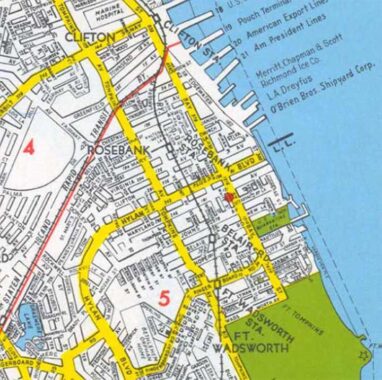
On this page I’ll cover the SIR route in Rosebank and Clifton, from south to north. The line was built as a steam railroad at grade in the mid-1800s, crossing side streets away from major routes like Bay Street and Tompkins Avenue, crossing Bay at the Clifton station to run near the shoreline north to St. George.


Fingerboard Road, seen here at Hylan Boulevard, was according to legend named for a large sign in the shape of a pointing finger (like the Clam Broth sign in Hoboken) that pointed travelers to the county seat that in the colonial era and decades after was located mid-island in Richmondtown. As this map indicates, it had received its name by 1873 and probably a lot earlier than that. Fingerboard Road, and West Fingerboard Road west of Hylan Boulevard, connects to Richmond Road that goes directly to Richmondtown. The Fort Wadsworth SIR station was located on Fingerboard Road just east of Tompkins Avenue until its closure in 1953, and as stated earlier, it attained its final design in 1937.
The “stadium” sign points to Staten Island University Hospital Community Park, formerly Richmond County Bank Ballpark, present home of the Atlantic League Staten Island Ferryhawks and Wagner College Seahawks and former home of the Class A Staten Island Yankees. Interestingly the Staten Island Railway employed a short section of its abandoned North Shore Branch to deposit patrons at the ballpark until that service was discontinued.
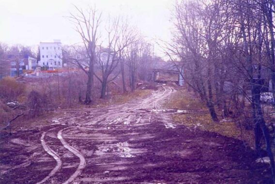
I was wandering on Fingerboard Road near Tompkins Avenue in 1999, looking for traces of the old Staten Island Railway (Staten Island Rapid Transit) right of way, when I saw this tract that had been cleared out for new housing.
The South Shore SIRT branch left the main line in Clifton and served the communities of Rosebank, Arrochar and South Beach before its abandonment in 1953, along with the North Branch along the Kill Van Kull that parallelled Richmond Terrace. Staten Island needs more mass transit these days, so this act seems shortsighted, but in 1953 the Verrazano Bridge was an idle fancy in the brain of Robert Moses, the island was still underpopulated in many areas compared to today, and the Baltimore and Ohio Railroad, which operated the SIRT then, wanted to trim away unprofitable lines.
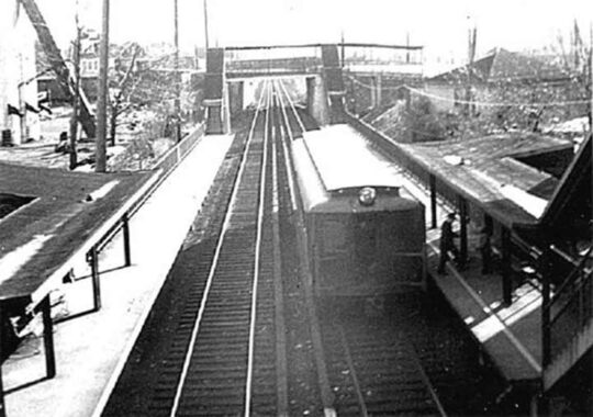
A 1950 view of the Ft. Wadsworth station. The Tompkins Avenue overpass is in the distance.
The northeastern tip of Staten Island, its closest approach to Long Island, has been protected by fortifications since 1663, when a Dutch blockhouse was established. The area was known as Signal Hill during the colonial period and the Revolutionary War: this was a crucial site from which to spy approaching British vessels.
Well into the 1970s, nearby Ft. Wadsworth was considered the oldest continuously staffed military post in the USA. In September 1995 the fort became part of the National Park System; its grounds and military museum are open to the public. However: part of it is still used by the Coast Guard, and those parts of the grounds are closed to the public. A designated 1.5-mile trail winds past both Battery Weed and Fort Tompkins. Call (718) 354-4500 for general information and hours.
The US Army never totally left the fort, as the US Army Reserve has had units based out of the former fort since transferring it to the US Navy and saw units activated multiple times over the past 41 years. The buildings they were using received renovations or were built new in 2011, with the facility serving as a base for the Superstorm Sandy relief efforts for months after the storm. The base was named Fort Wadsworth for Gen. James S. Wadsworth, an 1862 NY State gubernatorial candidate who served with distinction at the battles of Bull Run, Fredericksburg and Gettysburg and was killed at the Battle of the Wilderness in 1864. Staten Island’s and Manhattan’s Wadsworth Avenues also bear his name.


Hard to tell from the photo, but Cabot Place, between Hope Avenue and Belair Road, slants to match the angle of the SIRT tracks as they passed through.


The group of attached houses on the north side of Belair Road at Cabot Place marks the former location of the Belair Road SIRT station, which here was in an open cut. The photo (courtesy Gary Owen) shows the station after its 1936 improvement. The station was at grade in its early years.
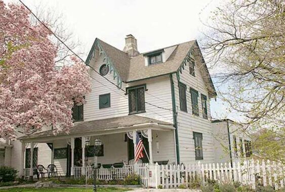
A few blocks away at 33-37 Belair Road is a designated NYC Landmark, Woodland Cottage. It was constructed in 1844 as part of a real estate development, one of a number of Gothic Revival small to medium size residences built in the same era. The detailing is reminiscent of the work of Alexander Jackson Davis although the architect is now unknown. There is an addition, ca. 1900, added late that is out of the picture on the western end of the building. The Woodland Cottage served as the rectory of St. John’s Episcopal Church on Bay Street from 1858-1869. Photo courtesy Emilio Guerra
There are other Gothic cottages on Belair Road between Bay and Clayton Streets, but none have Landmarks protection and have been subject to various alterations by their owners. Still, the original appointments can be seen here and there.
Rosebank and Clifton are full of one-block streets and dead end alleys. Clayton Street is one of these, a single block between Belair Road and St. John’s Avenue. There’s a surprise at its north end. If you’ve followed Forgotten NY for the last 25+ years, you may know what I’m talking about.


One of the most identifiable remnants of the old Staten Island Railway can be found at St. John’s Avenue and Clayton Street — a stone wall stamped with the date 1936. The railroad once passed here north of the Belair Road station. Service ended in 1953, and gradually, all trace of the railroad in the neighborhood has otherwise vanished. 1936 photos courtesy Gary Owen.


These photos from 1936 show the new SIRT overpass when it was brand new. One view looks east on St. John’s Avenue; the wall on the right side remains in place. The other photo looks south on Clayton Street.
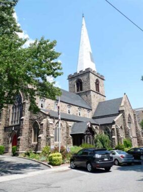
At Belair Road and 1331 Bay Street stands historic St. John’s Episcopal Church, constructed from 1869-1871 with architect Arthur D. Gilman. The parish was established in 1843, and its historic plaque claims that ferry/railroad magnate Cornelius Vanderbilt (born nearby in Stapleton in 1794) was the first child baptized in the original frame building across the street, but those dates don’t seem to jibe.


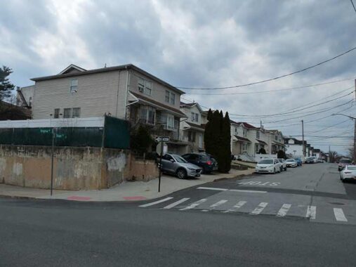
I walked north on Anderson Street, which runs for 8 blocks in Rosebank between Lynhurst and St. John’s Avenues and paralleled the old SIRT branch about two blocks east of it. I selected it because it’s the rare north-south route in Rosebank other than Bay Street and Tompkins Avenue that runs for more than a block or two. It still retains some traces of old-time Rosebank, with small freestanding homes, some empty lots and even some sidewalk-free sections.


For a breather (it was hot for the end of March, 80 degrees) I stopped for a seat on a bench at Kaltenmeier Playground, Anderson Street and Virginia Avenue; I was curious about the name, since it’s also the name of a nearby alley (see below). The NYC Parks website explains it thusly:
This playground is named in honor of Reinhard E. Kaltenmeier (1876-1933), who hailed from Rosebank, Staten Island and ascended the ranks of city politics. This land functioned as a park for 14 years before coming under NYC Parks’ jurisdiction.
Known as Rosebank Park in 1925, the State of New York owned the property and NYC Parks had a permit to operate the parcel. The city acquired the land from the State on January 21, 1934, and the Board of Aldermen re-named it Reinhard E. Kaltenmeier Playground in 1936. The city transferred the property to NYC Parks in 1938, and after construction of a playground, it re-opened on March 28 of that year. A bronze tablet, on a pressed concrete plinth, lies near the Virginia Avenue entrance in memory of Kaltenmeier. …
|
By 1902, Kaltenmeier had taken interest in politics and became the captain of the second district’s Democratic Party. The family grew, as Mary bore four children by 1904: Marguerite, May, Reinhard Jr., and Rose. Mary died in January 1909, and Kaltenmeier continued raising his family, running the saloon, and pursuing his political career. At the same time, he began selling insurance, and through the 1910s and 1920s, he rose to become a prominent insurance salesman. Kaltenmeier continued managing the saloon until 1920 when prohibition closed the business.
|
Good luck in politics followed bad luck in business. In 1921, he was elected to the Board of Aldermen (predecessor of the City Council), and was re-elected five times. Kaltenmeier’s tenure in public office was tempered by the loss of two of his children. His 24-year-old son, Reinhard Jr., died in December 1924, and within eight months, his youngest daughter, Rose, died at age 20. That year he moved out of his life-long residence on St. Mary’s Avenue.


1952 image courtesy Gary Owen
Consulting the 1949 map excerpt above, the Rosebank SIRT station was located at St. Mary’s Avenue and Tilson Place. It’s well-chronicled on Gary Owen’s SIRT website, with vintage photos of its “old” and “new” (before and after 1936) incarnations.
Today, the athletic field for nearby PS 13 (rebuilt since the SIRT days) occupies the old trackway on the south side of Virginia Avenue where a RR overpass used to be, and new housing on its north side.
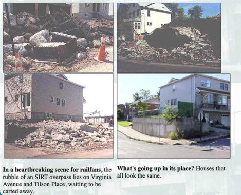
In 2000, I chronicled the ruins of the Virginia Avenue overpass at Tilson Place, which ran along the east side of the tracks.
As it turns out, new housing had been built on the west side of Tilson north of Virginia Avenue; however, part of the old SIRT concrete wall was retained, a parcel I thought another house would be built on. Few except area oldtimers know it was once part of a railroad overpass. Good thing I got this shot because this scene has been blanketed with a Blur of Anonymity on Google Street View.


I have always been curious about Kaltenmeier Lane, which runs for a block between Tilson Place and Anderson Street north of St. Mary’s Avenue. Until I coulted NYC Parks for info on nearby Kaltenmeier Playground in 2022, I had no idea who it had been named for.


There’s an unusual arrangement on Chestnut Avenue west of Anderson Street. One side goes up a ramp and dead ends; another continues west to Tompkins Avenue. This of course came about when Chestnut was bridged over the SIRT and ramped on both ends. The SIRT ended service in 1953, and I do not know how long the bridge and ramp remained in place, but the bridge was eventually eliminated and the eastern ramp cut back and left in place, as several homes had already been built beside it. 1937 image, courtesy Gary Owen.


Another one-block Rosebank street, Langere Place, runs on a curve between Lynhurst and Willow Avenues west of Bay Street.


There was a rusting iron stanchion and a concrete wall that carried the SIRT over Willow Avenue and Langere Place in Clifton. The SIRT alternately ran at grade and on concrete and iron overpasses near its junction with the SIR Tottenville branch. Note the “Bridge No. 4” sign. Trains ran here until 1953.
As of 2012 this, too, had been torn down.
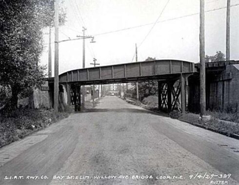
A look at the SIRT Willow Avenue bridge, a.k.a. Bridge #4, in 1929. Gary Owen.
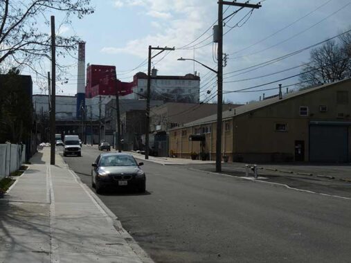
Looking north on Willow Avenue reveals a view at the massive former DeJonge paper factory, now a storage center, along the SIRT tracks at Tompkins and Greenfield Avenues. No doubt, the factory once had freight sidings along the tracks.
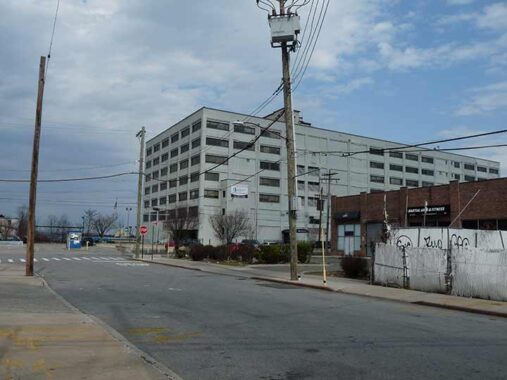
Here is the Pouch Terminal Building, Edgewater St. at Willow Avenue east of the SIRT trackway. Alfred J. Pouch, who founded the American Dock Company in 1872, and his son, William H. Pouch, built Pouch Terminal in 1917, a pier and warehouse complex facing the Narrows on Staten Island’s north shore. Inbound freight arriving at Pouch Terminal came directly from ships or lighters at the Pouch Terminal piers, by carfloat via the Baltimore & Ohio Railroad St. George Terminal, or via the Staten Island Railway (Baltimore & Ohio Railroad) via New Jersey and the Arthur Kill vertical lift bridge. Pouch Terminal ended service in 1979. It later became an electric generating plant, and it is currently a mixed-use building called Edgewater Plaza, whose tenants have included North Shore LIJ/Staten Island University Hospital, the New York City Police Department, the city Board of Elections and Community Board 1.
William H. Pouch has a Boy Scout camp near Seaview Hospital bearing his name; I imagine he was a major $$ contributor.


After a 5 hour walk that began at Clifton station and wound up there. Active Staten Island Railway stations assumed their present form, with railings unique to NYC transit and glass block partitions, in the 1980s, while station lighting assumed its current form several years later. Until a few years ago, Clifton featured a decades old passenger shelter that has since been torn down.
More from defunct Staten Island Railway trackways
Several trackways along the SIRT South Beach remain south of Tompkins Avenue, but I’ll tackle those on a separate post.
Check out the ForgottenBook, take a look at the gift shop. As always, “comment…as you see fit.” I earn a small payment when you click on any ad on the site.
6/8/26
8 comments
Thanks, Kevin for this very thorough review of the long-lost South Beach SIRT line. Hard to believe that Staten Island lost two rapid transit lines just a decade before the explosive population growth prompted by the Verrazzano Bridge opening in 1964. One point of clarification: the current St. George Ferry Terminal is only a facelifted version of the 1950 terminal, which itself replaced the 1905 terminal that did indeed burn down in a spectacular fire in 1946. NYC seems to have fire safety problems with the St. George and Whitehall terminals, both of which have burned down at one point or another over the past 100 years!
This may be jumping ahead to your next installment, but the story I’ve heard is that the designers of the Verrazano made the Lily Pond Avenue overpass on the bridge approaches especially wide (five traffic lanes) in case the South Beach branch ever got revived. It may seem a bit fanciful but consider that the branch had only recently been closed when bridge design work began and Lily Pond followed the right of way.
It is a sad commentary that the South Beach branch ended with the demise of the South Beach amusement area. At its terminus in South Beach, one could board a trolley line connecting to Midland Beach, another “resort” area formerly served by steam ships from Manhattan My grandfather served as a trolley conductor on this line. Later he served as and engineer on the waste water pump station in Ocean Breeze. .Much of the demise. of this transportation was caused by NYC colluding with General Motors to implement bus service to replace existing mass transit in the 1950s.
When I first visited SI in the 60s, there was still a small amusement area.
It’s true that by 1953, SIRT ridership had dropped due to reduced bus fares, but there is more to the story that has been lost to history over the 73 years that have passed. Reduced bus fares came about because of a sudden changeover of the bus network to the public sector. In February 1947, the Staten Island bus routes passed from private hands (Isle Transportation Company) to the public sector (NYC Board of Transportation). Isle Transportation did not sell out, but simply surrendered its franchise to the Board of Transportation because Isle could not earn enough from fares to pay its bills. Isle’s fares were based on zones, and fares ranged from five to twenty cents, depending on the trip length. SIRT fares were similarly distance based, as it was operated as a commuter rail service.
In July 1948, as part of a citywide fare restructuring that raised the subways to ten cents, all NYC Board of Transportation buses were increased from five to seven cents. For most Staten Island commuters it was a fare reduction, since the old Isle zones were retained until that time. The new cheaper bus fares induced many SIRT riders to switch to the now cheaper buses. The bus riders received an additional benefit because they received transfers to and from the IRT and BMT subways at South Ferry. Thus, a trip between anywhere in Staten Island and anywhere in Manhattan became 17 cents one-way – bus and subway for 12 cents surrounding the five cent ferry.
Result was that SI Railway patronage dropped from 14 million annually in 1945 to 4 million in 1951. Thus the two small branches were eliminated, and the remaining line between St. George and Tottenville was retained.
Re: William H Pouch
Greetings from San Tan Valley, AZ. The name Pouch is familiar to me. Staten Island is the location of a Boy Scout camp, the only one within the NY City limits. As a member during my childhood I spent several weekends each school year camped out there. I’ve forwarded a link to the Camp Pouch website. I’m glad it’s still active. Although you overlooked the BSA connection, I’m glad that this terrific campground survives’
https://camppouch.org/
I too remember the Staten Island amusement area.Up on high it had one of those
clown mannequins whose upper body rocked back and forth and who laughed
incessantly via a tape recorder.The stuff of legend
There have been a variety of names associated with this railroad, but to be both clear and precise do note these particulars. The original route, completed in 1860 between Clifton and Tottenville, was the Staten Island Rail Road Company. This company had been incorporated in 1851, but construction did not begin until 1855. It would be acquired by the Staten Island Railway Company in 1873.
A separate company, the Staten Island Rapid Transit Railroad Company, incorporated in 1880, would build its line from South Beach, through Clifton and St. George, and along the north shore to Arlington and a bridge at Arthur Kill. It would lease the Staten Island Railway Company from 1884. It defaulted in 1899, the lease was terminated, and its remaining property was transferred to the Staten Island Rapid Transit Railway Company.
The Staten Island Railway Company was later merged into the Staten Island Rapid Transit Railway Company at year-end in 1944 (along with the Baltimore and New York Railway Company, which operated the railroad from the bridge at Arthur Kill to Cranford Junction in New Jersey).
On 7/1/1971 the City of New York acquired the railroad between St. George and Tottenville. It leased this railroad to the Staten Island Rapid Transit Operating Authority for passenger service.
The Staten Island Rapid Transit Railway Company retained trackage rights for freight service along the city-owned line, but on 11/1/71 the freight railroad changed its name to the Staten Island Railroad Corporation. In 1995 the railroad, then a subsidiary of CSX Corporation, was sold to the Staten Island Railway Corporation, a subsidiary of the New York, Susquehanna & Western Railway Corporation. The freight railroad would be abandoned in 1992, with the right-of-way later being acquired by the City of New York and the State of New Jersey.
While the MTA adopted the name MTA Staten Island Railway for marketing purposes, it did not actually change the name of the Staten Island Rapid Transit Operating Authority. The annual disclosures of the MTA distinguish between the various marketing names and the actual names of all of its subsidiaries and affiliates. See http://www.mta.info/investor-info/disclosure-filings.
All of these names are so similar that it is easy to confuse one with another.