
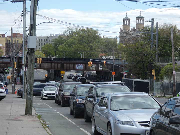

A recent walk in Morris Park (May 2026) produced 121 photos, which will make up a post eventually. I like the Morris Park and Westchester Square Bronx regions and always turn up something I haven’t found yet there. In this view we are looking south on Bronxdale Avenue, which cuts diagonally across Morris Park from Bronx Park southeast to East Tremont Avenue. Railroad tracks carrying Amtrak trains are bridged across the avenue. Amtrak service extends to Boston as well as other Connecticut, Rhode Island and Massachusetts towns. Metro-North hopes to open four stations in the Bronx along these tracks by 2030: we shall see.
Twin steepled St. Raymond’s Church, East Tremont and Castle Hill Avenues, is seen at right. The parish was instituted by the Reverend “Dagger” John Hughes in 1842 and after waves of immigration caused the congregation to burgeon rapidly, the present large church building was constructed in 1898. The parish runs St. Raymond’s Cemetery, in two separate large plots, on Schuylerville along the Hutchinson River Parkway.
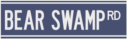
Bronxdale Avenue is a Native American trail and one of the first routes through the neighborhoods that became Bronxdale, Van Nest and Morris Park, and from the colonial era through the early 20th Century, it was named Bear Swamp Road.
One of the Bronx River’s vanished freshwater wetlands was the Bear Swamp. Draining into the Bronx River about where the Bronx Zoo’s Boston Road entrance is today, it covered over 180 acres east of White Plains Road in the present-day Bronxdale and Van Nest neighborhoods. Bronxdale Avenue follows the line of the old Bear Swamp Road that ran through this marshy area. There may have been a Native American settlement there at one time: in the early 1800s a basin for grinding corn was found cut into a rock outcrop. [Bronx River Alliance]
The Siwanoy Indians did indeed hunt and trap black bears here; they used teeth and claws for ornaments and talismans, and the pelts for coats and blankets. Bear meat is not commonly found at the Stop & Shop, but the Siwanoy considered it a delicacy, and the fat was drained for use as hairdressing or bug repellent.
More unusual NYC former street names
Check out the ForgottenBook. As always, “comment…as you see fit.” I earn a small payment when you click on any ad on the site.
6/18/26
5 comments
Thanks for posting. My wife grew up in The Bronx so these scenes are always appreciated.
However, please accept one minor correction. Currently, Metro North trains do not use these tracks – only Amtrak passenger trains between Penn Station and Boston, plus Norfolk Southern and CSX freight trains. It is certainly true, as noted in the posting, that Metro North trains will serve this line at four new stations beginning in 2030. Those trains will operate to and from Penn Station via the Hell Gate Bridge.
Currently Metro North operates a very intense service to and from Grand Central. Its Harlem and New Haven lines operate through the central Bronx along Park Avenue, while its Hudson Line hugs the west shore of the Bronx following the Harlem and Hudson Rivers. The Harlem Line runs to/from Brewster NY, while the New Haven line runs to/from its namesake Connecticut city. The Hudson Line runs to/from Poughkeepsie, NY.
.
This always stumps me.
Granted, it’s confusing. Metro North’s Harlem Line is not named for the upper Manhattan neighborhood or the adjacent river. It is named for the Harlem Valley, in Dutchess County NY near the Connecticut border. The Harlem Valley comprises the towns and hamlets of Pawling, Wingdale, Dover Plains, Wassaic, Millerton, Millbrook, and Beekman. The valley is part of the 2,190-mile-long Appalachian Mountain landscape known as the Wild East. Information is from the website https://appalachiantrail.org. Metro North Harlem line trains still serve the area today, including a station known as Harlem Valley-Wingdale.
In fact, let me take this opportunity to correct my original posting. Should have said that Harlem Line electric trains run to/from Brewster NY (last electric stop is named Southeast, for the Putnam County town where it is located), 53 miles north of Grand Central. Diesel train service continues on the Harlem Line for another 29 miles to Wassaic, NY.
The Metro North Hudson Line, on the other hand, does follow the Harlem River’s east bank from 161st Street to the Hudson River in Marble Hill, where it swings north and follows the Hudson to Poughkeepsie. Amtrak trains, and freight trains, continue along the Hudson all the way to Albany.
New York Central Railroad trains followed river valleys in order for the tracks to stay level. Indeed, the NY Central advertised its New York – Chicago sleeper trains as the “water level route – you can sleep” to compete with rival Pennsylvania Railroad, whose trains had to cross the central Pennsylvania mountains running between those two cities, no doubt interrupting some sleeping passengers.
I was raised not too far from there in Parkchester. I’m long gone from there (retired & relocated to Arizona 21 years ago). As I recall East Tremont Avenue was paved with cobblestone. Has this changed?
There are a few small spots where the cobblestone peeks out, but for the most part it is all paved over.