
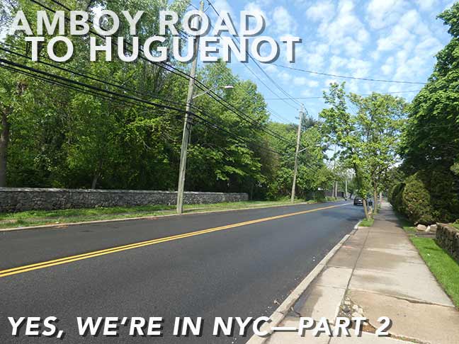

In May 2026, before the humidity set in for good, I took LIRR, subway, boat and Staten Island Railway to Pleasant Plains, a neighborhood in Staten Island I had probably not been in for a decade…during that time there was a pandemic, I had a hernia and back issues (still with the latter) but I’m “playing through the pain” especially mornings, and I’m catching up on areas I haven’t visited in a long while (cf. my Travis visit in August). I walked east on Amboy Road, touching on Pleasant Plains, Prince’s Bay and Huguenot; I had previously traversed Amboy Road west to Huguenot in January 2020, so gradually I’m seeing one of Staten Island’s lengthiest roads, which remains a narrow two-lane for much of its span from New Dorp to Tottenville. Pleasant Plains, which numbers 5000 residences, was given its name by the builders of what is now called the Staten Island Railway in 1860. The area is generally flat, with a couple of hills that will surprise you.
GOOGLE MAP: PLEASANT PLAINS – AMBOY ROAD
In Part One I had gotten as far east as Amboy Road and Bayview Avenue. I realize I’m giving Pleasant Plains, Prince’s Bay and Huguenot short shrift by simply traveling along Amboy Road, and I hope to flesh out Staten Island’s south shore with additional trips including Mount Loretto (where I haven’t been since 2007!). As recounted in Part One, though, Staten Island Railway weekend service will have to improve before I assay any of this.


Citgo service station, NE corner of Amboy Rd. and Scudder Avenue. As the 1940 tax photo attests, there has been a service station of some kind on this corner for a long time. Citgo, which has used a triangle in its logo for a long time as well, is the descendant of Cities Service Gas Development Company formed by Henry Doherty in 1910 in West Virginia. Probably the most famed Citgo sign is a huge one located in Kenmore Square, Boston, visible from Fenway Park.


#5910 Amboy, east of Scudder Avenue and across from the Lemon Creek-Sandy Brook Bluebelt, is so nice, I shot it twice. Though it’s not (yet) recognized by the Landmarks Preservation Commission, since 1982 it is on the National Register of Historic Places. “It is frame house, sheathed with clapboard siding with a three bay central section flanked by two ‘stepped down’ flanking wings.” It was constructed in 1843, for farmer Abraham J. Wood. I was attracted to its trio of attic eyebrow windows.
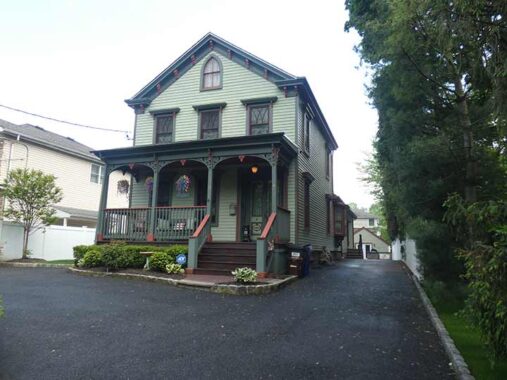
Of similar vintage, though a different architectural category, is the next house east, #5890 Amboy, unrecognized by any official agency. I do take “points off” for its paved over front yard but it’s well-maintained otherwise.


I’m good at recognizing which houses are vintage. Here’s #5859 Amboy Rd. at Parkwood Avenue, whose many-gabled Queene Anne outlines are still noticeable, despite its homogenization. Of interest in the 1940 photo is the sign in front: “H.W. Ekstrand, Builder” and the phone number I can’t make out in its entirety.
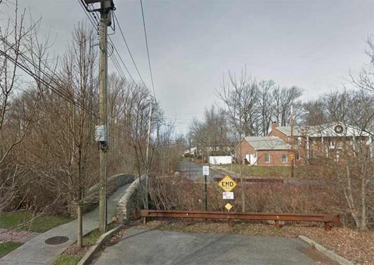
Parkwood Avenue is interrupted by the Sandy Creek Bluebelt, but I noticed on Street View that pedestrians can traverse it via this picturesque stone bridge: the kind of detail that doesn’t turn up on most street maps. In fact this particular Bluebelt area went unshown on most print maps such as Hagstrom, as the area was assumed to be developed in the future. However, it’s one of the many “natural” areas in Staten Island that have been mostly left to nature.


Odell Place, which looks more like a driveway than a mapped street, is a dead end snugly along the Sandy Creek Bluebelt. The most famed Odell I know of is Odell Beckham, who is back with the NY Football Giants in 2026 after several years away. As short as it is, Odell Place has a subname, Laurence Curia Place, a Cantor Fitzgerald employee who perished during the terrorist massacre on September 11, 2001.


Seguine Avenue begins at Amboy Road and plunges south to Raritan Bay, passing by the historic Seguine Mansion. Confusion has existed for decades about the neighborhood’s correct spelling, though most signs have it correctly now, including the “official” sign on Amboy Road and Seguine Avenue shown here. After the Revolutionary War ended, New York City virtually divested itself of royal place names, though Prince Street in Manhattan and Kings Highway in Brooklyn are still there. (I’ve since learned Prince Street ia named for a real neighborhood setttler, not a King’s son.) According to tradition, Prince’s Bay is so-called because before the Revolution, a British prince, the Duke of Nassau, who later became William III (he co-reigned with his wife and first cousin Mary II as William and Mary), once anchored a vessel in the actual bay at the foot of today’s Seguine Avenue. The name of the area is properly spelled with an apostrophe, though variants due to mispronunciation like “Princess Bay” have appeared in print. The French Huguenot Seguine family were early settlers in the area and resided here for a couple of centuries.
“Seguine”‘s pronunciation baffles me, as well, since I look at the word and sound it as “sa-GEENE”, but I am told that area residents pronounce it “sa-GUY-n” with a long “y.” Doesn’t seem natural to me, but I won’t judge.
I’ve shambled around Prince’s Bay a bit more often than Pleasant Plains, and wrote this examination back in 2015 (about time I returned, but I didn’t on this trip).


Sampling of homes, including some Tudors, on Amboy between Foster Road and Vernon Avenue.


East of Vernon Avenue, an undeveloped parcel can be seen along the north side of Amboy Road. Part of it has been developed as the Woodhull Playground as it borders Woodhull Avenue and Drumgoole Road South. This is the site of a “paper road,” the Wolfe’s Pond Park Spur, which would have connected Drumgoole Boulevard (now Korean War Veterans Parkway) with the south shore and another road that was never built, named South Shore Drive or Shore Front Drive depending on what map you consulted, which would have run along Raritan Bay. Both roads existed in the dreams of Robert Moses and city planners, but they were never begun (much like the Willowbrook Parkway extension to Crooke’s Point.)
Wolfe’s Pond is a freshwater pond situated a few yards from the salty Atlantic Ocean. The water remains fresh because silt and sand dam off the salty water from the ocean. The large park surrounding it is named for original landowner Joel Wolfe, who farmed the land here until 1857. It became a public park in 1929, and has remained free of Mosesian dreams.
I scanned a section of a 1969 Hagstrom showing the spur. Notice that even the super-accurate Hagstrom got Prince’s Bay wrong. This was repaired in subsequent editions.
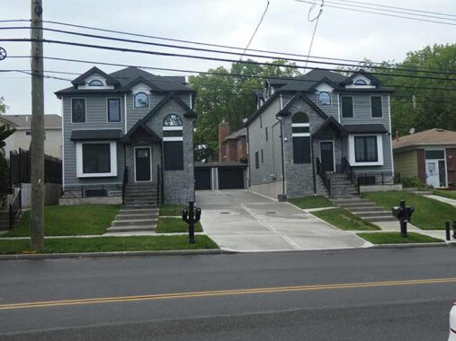
Some critics have said I don’t like any new construction. False: I don’t like ugly new construction. I like these two homes, on Amboy Road just west of dead-end Addison Avenue. They’re not boring, and have dormers and gables, differently shaped windows, and were completed in 2025. I like the square first-floor windows. Were the window placements supposed to suggest a face? Perhaps.
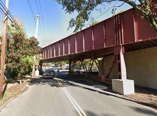
The Staten Island Railway is bridged over Amboy Road twice — here in Huguenot Park and a few miles east, in Bay Terrace.
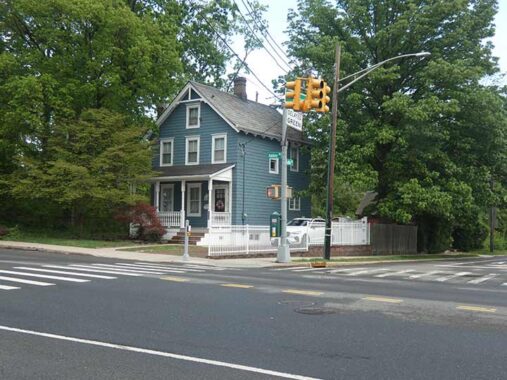
One of many perfect cottages along this stretch, at Amboy Road and Luten Avenue. It once had a close copy alongside it years ago, but Luten Avenue’s construction claimed it. Luten Avenue runs along the east side of Tottenville High School, so named even though it’s a few miles east of Tottenville. The school was founded in 1898 and moved to the current location in 1972.


East of Luten Avenue, Amboy Road encountered two roads named for prominent South Shore families. Peter Androvette was became president of the Kreischer brick works and later resided in the now-demolished Edward Kreischer mansion, seen on this FNY tour in 2017. Before the brickworks arrived, modern Charleston was called Androvetteville after the landowning family. Androvette sounds like a French name and the family were likely Huguenots (Calvinist Protestants; see below).


The Prall family were Dutch and arrrived in New York in the early 18th Century. Descendants owned property well into the 20th century, and this road was named for the family. Prall’s Island, an uninhabited island used as a bird sanctuary, is located in the Kill Van Kull west of South Avenue and the large Amazon and Ikea logistics centers.
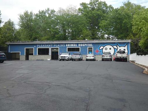
Pleasant Plains Animal Hospital actually has two locations: one in Huguenot Park, and another on Forest Avenue in Port Richmond…neither one actually in Pleasant Plains! Both have similar construction, blue walls with white type.
Huguenot (Park)
A Swiss political leader, the burgomaster, or mayor, of Geneva, Bezanson Hugues (1491–1532) ultimately gave his name to this neighborhood on Staten Island’s southeast shore between Arden Heights and Charleston. After Martin Luther founded Protestantism in Germany with his 95 Theses in 1517, the movement spread throughout Europe and ultimately worldwide, France was no exception though French royalty fought fiercely against it, instigating the French Wars of religion in the late 1500s and continued severe repression of members of the French Reformed Church, or the Huguenots, as they came to be called after Hugues provided some key leadership, led some to immigrate to the new world including sStaten Island. French Protestants would not gain equal rights as citizens until 1789.
While “Huguenot” is pronounced somewhat phonetically as HUGH-ga-not in Staten Island, in the original French it’s more like “ee-ga-noh,” with the ee more on a nasal “oo” close to the “ee” sound.


Famed architect Ernest Flagg is well-represented ll over NYC, from the Singer Tower, demolished in 1968, to Flagg Court in Bay Ridge (where I once aspired to move but couldn’t afford) to his mansion in Todt Hill that became a Catholic retreat house.
He’s also represented here at #5475 Amboy Road at Huguenot Avenue as he designed the Huguenot Reformed Church, which also been known as the Memorial Church of the Huguenots. The chucrh in Staten Island was founded in 1849, while the present building’s cornerstone was laid in 1924, as the National Monument of the Huguenot-Walloon-New Netherlands 300th Anniversary of Religious Freedom. Flagg’s design is said ton be reminiscent of meieval Norman architecture from northwest France. This church replaced an earlier building built in the 1850s that burned down, it is said, from a cinder thrown up by a passing steam locomotive on the SIRT.
Huguenot Avenue has been a main north-south route for decades and is the westernmost surface road that directly connects Arthurkill Road and Hylan Boulevard. Long noted for the beauty of its woodlands, Huguenot began to be transformed soon after the Verrazzano-Narrows Bridge opened in 1964, leading to a large number of Brooklyn residents relocating to Staten Island.


This locksmith, on the church grounds, could qualify as one of Staten Island’s smallest freestanding buildings. “Holden’s Staten Island” also mentions the smallest branch of the NY Public Library here…could this be the same building? The present Huguenot Park Library is located at #1231 Woodrow Road.


In this “downtown” area of Huguenot Park, many of the buildings are old indeed, but have been heavily surfaced so only the outlines remain to tattle on their ages.


Wrapping up at the Huguenot SIR station. The train was running every 45 minutes. The brick station house from the 1930s remains from a grde crossing elimination project, but the station itself was renovated in the 1980s (which eliminated the wood plank platform). The original very steep steps to the platform from the Thirties remains.
Check out the ForgottenBook (HarperCollins, 2006), as well as Forgotten Queens (Arcadia, 2013). I also have a chapter in the anthology “New York Calling: From Blackout to Bloomberg” (Reaktion, 2007). As always, “comment…as you see fit.” I earn a small payment when you click on any ad on the site.
9/20/26
2 comments
Are Dead End signs becoming extinct?
This old North Shore boy becomes more appreciative of Staten Island’s South Shore as he gets older. Nice, quiet and clean, which is what I seek in a neighborhood. Yes, the old locksmith building was indeed a VERY small NY Public Library branch until a larger branch opened up at Huguenot Ave and Drumgoole Road in the early 1980s. That branch just relocated to a newer, larger location on Woodrow Road, and the 1980s library is now an Islamic Center. Staten Island’s demographics, like her sister boroughs, are always changing. And while the SIR weekend headways during this round of construction were a bit long, it looks like Huguenot Station is getting an accessibility ramp, which is always a good thing.