
If you recall from last week, I started off at the Avenue U station in Gravesend and made my way northwest, up through Bath Beach, and left off at the Veterans Memorial Hospital on Poly Place, a longtime Brooklyn landmark I know too little about. My walk wasn’t done — i continued on up 7th and 6th Avenues, both routes I’ve neglected in recent Bay Ridge wanderings, and finished things off at the 59th Street BMT R/N station on 4th Avenue.
I grew up in Bay Ridge and resided there for 35 years, but today there’s little of “my” Bay Ridge remaining, as family has died or moved away. The area has a rich history, though, as NYC’s only active military fort, Fort Hamilton, is here; this was one of the landing points for the British when their attack force invaded the NYC area in 1776; a couple of Brooklyn’s older residences are here; and the neighborhood has a surfeit of short streets and dead-end alleys, unlike the rest of Brooklyn. Pretty much the last of my old Bay Ridge redoubts is my dentist, since I’ve been going to the same office and its two successive dentists since 1964.

Fort Hamilton is the crown jewel of Bay Ridge, an active fort on the southwest tip of Long Island since it was completed in 1831. It is situated on the Narrows, a strait separating Long Island and Staten Island, and a strategic point for any enemy vessels that would attempt to enter Upper New York Bay and then the island of Manhattan from the south. In the Revolutionary War, British troops invaded Long Island in August 1776 by landing on property near the future fort owned by a Denyse Denyse. Patriots fired on the British warship Asia during the invasion, but it was of little hindrance.
It might be odd to hear that Robert E. Lee, the great general of the Confederacy, was once a major figure in Brooklyn. While still a captain in the US Army in 1839, Lee was given the task of improving armament at Fort Hamilton as well as other forts in the region, and served here until 1846. A major east-west street inside the military reservation is named for him, and he was a vestryman at St. John’s Episcopal (Anglican) Church at Fort Hamilton Parkway and 99th Street. The church is still there, now on its second structure.
Fort Hamilton defended the United States during the Civil War, a conflict that Lee’s conscience led to join the other side. During the war, great advances in military technology were made, a frequent consequence of war. A series of short streets north of the fort in Bay Ridge were named for a trio of military engineers who vastly improved US armament: Richard Jordan Gatling, Admiral John Dahlgren, and Robert Parker Parrott. Their stories are on this FNY page.
Today, no civilians can enter Fort Hamilton (with the exception of the fort’s Harbor Defense Museum) without having prearranged their visit. That wasn’t the case, though, in the 1980s, when I pedaled through the fort with regularity; the USA wasn’t engaged in what seems like endless wars then. The policy changed at the onset of the First Gulf War in 1991. There were also buses routed through the fort that had to have their routes revised. Buses still go through Fort Wadsworth in Staten Island, which became a federally-administered park part of the Gateway National Recreation Area.
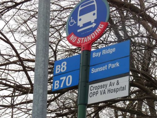
The B8 is the bus route that formerly traversed Fort Hamilton, but it’s been rerouted to 92nd Street. The route is a lengthy one, running from 4th Avenue in Bay Ridge to Rockaway Avenue in Brownsville. I used to take the B70 quite often when I lived in Bay Ridge; its route is little changed since then, running from Veterans Hospital to the waterfront at 39th Street and 1st Avenue, where, a few decades ago, it connected to a ferry. It runs along 8th Avenue, the spine of one of NYC’c Chinatowns.
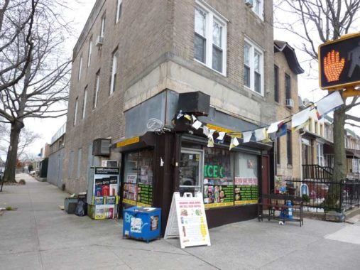
Note that the sign lists the street as “Cropsey Avenue.” The Department of Transportation prefers to call the two-lane street running along the south edge of Dyker Beach Golf Course as an eastern extension of Poly Place; the Veterans Hospital’s address is 800 Poly Place. The MTA, though, sticks with “Cropsey Avenue.”


Though there’s a Parrott Place and a Poly Place in Bay Ridge, neither have anything to do with the colorful birds with the big claws and beaks — Poly Place is named for Poly Prep. The wedding cake-white, 4-sided clock tower of what used to be called the Polytechnic Institute but is now Poly Prep Country Day School on 7th Avenue between 92nd Street and Poly Place can be seen from far and wide in Bay Ridge and Dyker Heights. Poly Prep, a private school for students from kindergarten through high school, was instituted on downtown Livingston Street in 1854 and was offered the present plot by Dyker Meadow Golf Club. In 1916, the school became the Poly Prep Country Day School, and the familiar clock tower, visible from all over southern Bay Ridge, was completed in 1917. Poly became fully co-ed in 1979. Alumni include pro basketball’s Joachim Noah, TV’s Calvert De Forest (Larry “Bud” Melman), and turn of the 20th Century mayor Seth Low.
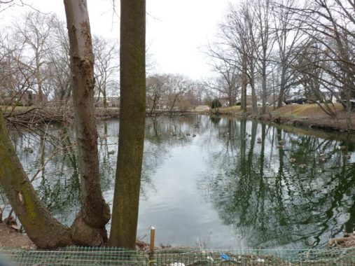
I’m not sure if Poly Prep’s duck pond, near the 92nd Street side, is a natural glacial kettle pond or not (there are a couple of more in Dyker Beach Golf Course), but natural or not, it brings a “country day” to Bay Ridge residents. On warmer days, the resident ducks and geese swarm the fence, asking for handouts, but a sign warns passersby to not fed the waterfowl.

The former Victory Memorial Hospital, 7th Avenue and 92nd Street. The hospital was founded in 1913 as an offshoot of the former Bay Ridge Hospital with a grant of $10,000, which is $250,000 in today’s money. Land formerly home to barns and greenhouses was acquired, and after a medical dispensary was located at the site for a few years, after several delays in construction, the new hospital, dubbed Victory Memorial for the USA’s recent participation in World War I, opened in the early 1920s. The original building can still be seen above as the brick building toward the middle of the picture.
Victory Memorial closed in 2007 and today the buildings are home to an urgent care center managed by SUNY Downstate. My mother perished at Victory Memorial in 1974, under treatment for breast cancer.
The Fights For Bay Ridge’s First Hospitals [Hey Ridge]
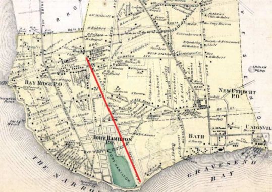
A look at the map of Bay Ridge in 1873, when it was part of the Town of New Utrecht. The street grid was still in the planning stages then, but Ovington, 3rd and 4th Avenues were already in use, while 7th Avenue (which I marked in red) and 86th Street were just lines on maps. A zoomable version can be found at the NYPL website.
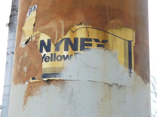
I last passed this highway sign stanchion at 86th Street and Dahlgren Place in 2006 — and this scrap of an ad for NYNEX has hung in there for a good 13 years. NYNEX was a previous moniker for the local telephone provider, Verizon at present; former names have been New York Telephone and Bell Atlantic. In 1988, NYNEX ran a series of TV ads for the Yellow Pages that were hilarious; here’s one.


I’ve shown 8302 6th Avenue on Forgotten NY before — I spent my childhood, teenage and some young adult years here, and moved back into the building from 1991-1993. In fact, I’m old enough to have spent parts of five decades living in this building — 25 years. Perhaps I’ll match that number in Little Neck, but I’ll need money to do that.
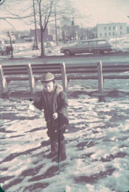


There is a small triangle across from the building, formed by 83rd Street, Fort Hamilton Parkway and 6th Avenue. I’m shown here around 1962 or so, when all the buildings across the street had been seized and then torn down, as traffic czar Robert Moses was running the Gowanus Expressway, the approach to the Verrazzano Bridge, directly through Bay Ridge. My father shot some photos of the expressway construction; I have included them on my Verrazzano Bridge page.
The triangle was named in 1994 for Tom McDonald, “longtime Bay Ridge community volunteer, activist and member of Community Board Ten.” For awhile, I had thought it was named for longtime WNYW-TV (Channel 5) sports guy Tom McDonald, but it’s not.
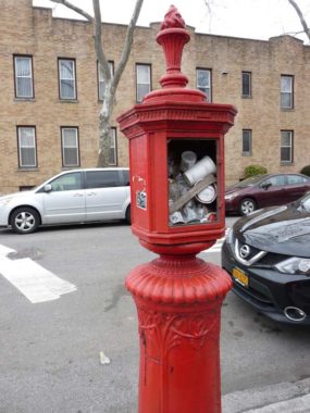
A decommissioned fire alarm at 6th Avenue and 82nd Street. New Yorkers, a resourceful bunch, invariably use these as garbage cans.
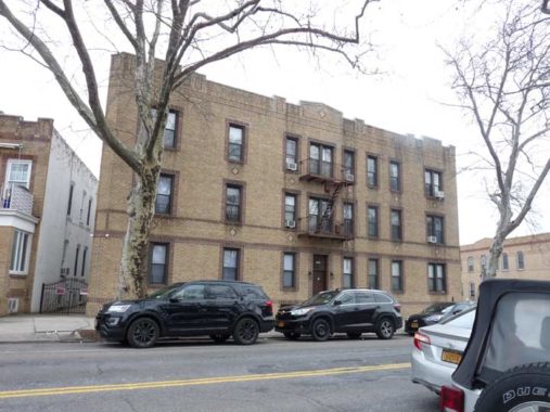
I have many odd, disconnected memories from my very early days in Bay Ridge. My grandmother and I would occasionally take walks up 6th Avenue before I was old enough to go to school; I later resumed these walks as a teenager and young adult with my grandmother after her daughter, my mother, had died and she was occasionally downhearted. Even in those early days, I took note of this apartment building at 6th Avenue and 81st Street because there were several cracked windows on the ground floor. (Over 50 years later, they’ve been replaced.)

In 1962 6th Avenue got a set of brand shiny new Donald Deskey lampposts sporting GE 400 lamp fixtures, replacing 6th Avenues’s older, long-armed Corvingtons. 57 years later, only a few remain, including this one at 81st Street. I credit this turn of events planting the seeds in my head about the transience of NYC infrastructure.
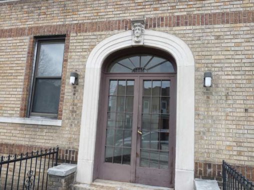
After 35 years in Bay Ridge and God knows how many times walking this stretch of 6th Avenue, I never noticed the goddess head over the entrance at 8005 6th Avenue before.
There’s been a convenience store at 6th Avenue and 79th Street since Time Immemorial. However, when I lived around here, I’d barely patronize it. Instead, I’d head over to 86th Street or a block north to 5th Avenue. The brain locks into certain habits and holds onto them like a bulldog.
At this corner, traffic is one way both west and east to 6th Avenue. Were it not for carefully positioned DO NOT ENTER signs, there’d be a lot of head-on collisions. Traffic on 79th between 6th and 7th Avenues was one-wayed west when the 79th Street overpass was opened over the Gowanus Expressway in 1964.
The architects of these homes along 6th Avenue in the 70s streets did a clever thing. The houses were built at an angle to the avenue. That way, both morning and evening sun is admitted. Had they been constructed parallel to the street, sun would be less plentiful.

76th Street is among my favorite side streets in the neighborhood because of its rows of attached brick buildings. Each has bays in the front which, again, allow sun from multiple angles. These row houses can also be found on Bay Ridge Parkway (called 75th Street by Ridgeites) and 74th Street.


Before there was ever a street grid in Bay Ridge, one of the main north-south routes was Stewart Avenue, seen here north from 74th Street just east of 6th Avenue. I told its story in 2008 on this FNY page.
I lived at 73rd Street and 7th Avenue in a railroad flat between 1982 and 1990. This corner market at 74th and 6th Avenue was my go-to deli. Note the attached homes adjacent to it, with sun-friendly angles.
The building has a matching bookend at 73rd Street and 6th Avenue. For many years, a caterer operated on the ground floor. However, when I first moved to the area in 1982, this was an old fashioned soda parlor, with a marble countertop and the works. I didn’t carry a camera then, so this was a great lost Forgotten NY opportunity.


A sampler of the diverse architecture along the stretch of 6th Avenue between Ovington and Bay Ridge Avenues. Older neighborhoods have a richer selection.
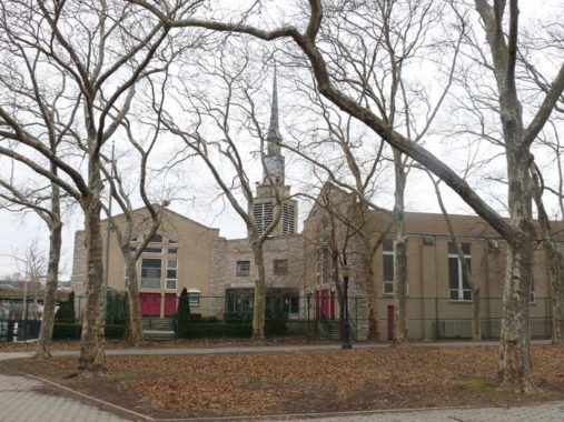
The First Evangelical Free Church, 6th Avenue and 66th Street, built in 1962, has services in languages for everyone –there are signs in English, Norwegian, Arabic and Chinese. It’s good to be as helpful as possible when your church is at a corner that reads 6-6-6. Across the street was a key location for me in my youth — Karl Droge Ice Cream.

Leif Ericson (c.960-c.1020) was probably the first European to set foot on the American continent, nearly 500 years before Christopher Columbus’s voyages.
Ericson was born in Iceland around 960, the son of Eric the Red, an Icelandic king who discovered and colonized Greenland. The Icelandic Sagas offer two explanations of Ericson’s famous voyage. One suggests that Ericson, en route to Greenland, was blown off course and arrived on the northeastern coast of America. In the other, he organized an expedition to confirm a previous report of hilly, heavily forested land west of Greenland.
The Sagas record that Ericson – afterwards known as “Leif the Lucky” – made three significant land discoveries in the year 1000. He named the first Helluland (Flat-Stone Land), now thought to be Labrador. He called the second Markland (Wood Land), possibly Newfoundland. The site of the third landfall, named Vinland (Vine Land) for the wild grapes found there, may have been as far north as Newfoundland or as far south as Cape Cod. The crew wintered in Vinland and returned to Greenland in 1001, drawing “behind them a boat filled with grapes.” NYC Parks
Lief Ericson, or Leiv Eiriksson, Square runs between 66th and 67th Streets as a corridor park between 4th Avenue and Fort Hamilton Parkway; its length was interrupted by the Gowanus Expressway beginning in 1959. It is named for what is thought to be the first European to sight the North American mainland, more than a millennium ago.

The Antenna King, Henry Langan, ruled the rooftops of Brooklyn from founding the store in 1967 at 6th Avenue and 65th Street on through the rooftop satellite dish era in the 1970s and 1980s. It’s little remembered now, but for decades, cable TV was unavailable anywhere but Manhattan and to get special programming like sports, bars and restaurants relied on satellite dishes.
That’s not to say, though, that I couldn’t get music videos without MTV. A short-lived music channel, U68, was available on Channel 68 on the UHF band in the mid-1980s. The picture was spotty coming in on my rabbit ears and only slightly more viewable via a rooftop antenna, and none of the megastars that had deals with MTV appeared on it, but it was better than nothing.
Cable TV finally came to Bay Ridge in 1987 and I was among the first subscribers. Pay TV was weird at first though.
Though the Langans still install rooftop antennas, their business is primarily exporting wireless cable antennas to the Middle East and Africa. Steven talked about his father’s non-antenna-related talents. “He’s the Antenna King, but he’s really an artist and kind of an inventor,” he said. Last month, a neighbor walked into the store, paged through one of the Antenna King’s sketchbooks, which was lying on a desk (the result of art classes he took at the Brooklyn Museum in the late nineteen-sixties), flipped past a detailed hand-drawn antenna ad captioned “$39.99 installed,” and pointed to a reclining nude. “That could be my wife!” he said. [The New Yorker]


Though the Gowanus Expressway overpass {I-278] looks as if it has been here forever, it’s about 55 years old, having been built from 1963-1964, running along 65th Street between 3rd and 7th Avenues.
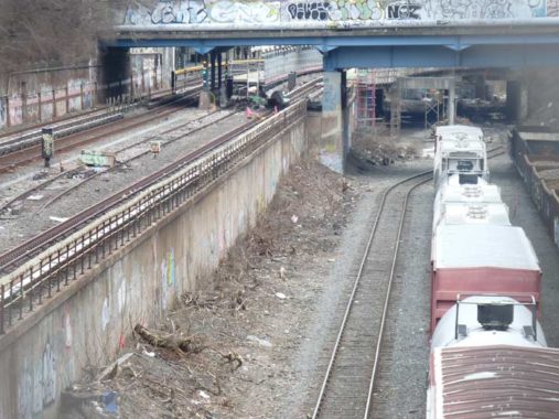
Though the fencing on the 6th Avenue overpass over the Sea Beach subway/Bay Ridge LIRR branch has very small openings, I was able to telephoto my way to a decent photo. From left to right: the two tracks of the BMT Sea Beach (N train); a BMT layup track; and two tracks carrying Bay Ridge Branch freight. Many decades ago, the LIRR also ran passenger service on this line.
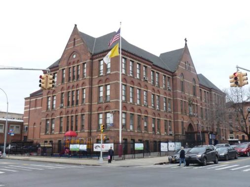
Though many Catholic parishes no longer operate associated parochial schools, the Basilica of Our Lady of Perpetual Help’s school, constructed in 1903 and predating the basilica itself, is still going strong in a should-be-landmarked building at 6th Avenue and 60th Street. The sixes are wild again!
The yellow and white flag is that of the Vatican, located in Rome Italy — the worlds’s smallest independent country and one of two such located within Italy, the other being San Marino.

The OLPH basilica itself, one of the largest churches of any denomination in Brooklyn, was dedicated on Easter Sunday 1909. The parish itself dates to 1892, established by the Redemptorists. The basilica is positioned on a hill and is easily recognizable from a ferryboat in Upper New York Bay.


A sampler of some of the attached houses seen along 59th and 60th Streets in the southern reaches of Sunset Park.
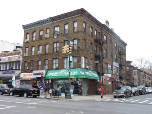
Kelly’s Drug Store (Pharmacy), 5825 5th Avenue corner of 59th Street, has held down the corner for quite awhile. How long?
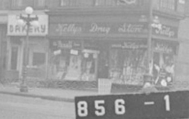
Here’s a photo from the NYC Municipal Archives, taken at Kelly’s in 1940. Unfortunately, it’s hard to say how long it has been there, since the internet is silent on its progeny.
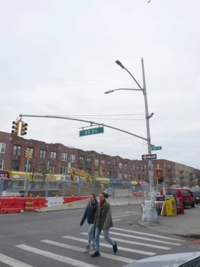
4th Avenue in the upper 50s has a run of “8th Avenue Special” poles with regular masts attached. Any lamppost buffs know why they were installed along his stretch?
Time to vamoose for home. The green globes mean, of course, this entrance works 24/7.
Check out the ForgottenBook, take a look at the gift shop, and as always, “comment…as you see fit.”
3/16/19
18 comments
How small is Vatican City? It covers fewer acres than a flower auction house in the Netherlands.
Excellent article, Kevin. You can find out what predated Kelly’s by digging through old Brooklyn phone/business directories at archive.org. I’ve done that numerous times to research people and businesses.
As a 70 year old born-&-bred Brookynite, I loved this post. I grew up in Marine Park and Midwood and barely knew western Brooklyn until adulthood. I was briefly a substitute teacher at s Bay Ridge public school in the early 70s (71st Street & Ovington?), but really got to know the area when my husband and I bought a house on 59th Street between 4 & 5th avenues (1981-1991) . Thanks for this great tour!
What year were the legs of Poly Place and Battery Ave that separated Ft Hamilton and Poly Prep closed to thru traffic? When I was younger I was able to explore the Ft Hamilton army base (Dad was a member of the NY National Guard, so I had a military dependent ID card) and checked out the area a few times.
I’d have to say the early 1980s
This article brought back memories. We used to walk from 75 St. and 6 Ave. to ice skate at the pond in the Dyker Heights Golf Course in the 50’s.
A god Irish lad like yourself should know better that to call the Redemptorists a ‘sect’.
Those NYNEX Yellow Pages commercials were priceless…I remember the ones for “Furniture Strippers” and “Vanity Cases”…
I remember they also had ads on bus shelters where you’d spot some wacky photo and then a week or two later they’re replace it with what it was supposed to be added in. One I guessed was a magnet holding up a sheep, which turned out to be ‘steelwool’
There was a fish store that sold terrific fish and chips, 3rd or 4th Ave, 75th Street or so…
That was Thompson’s fish market, Third Avenue between 72nd St. & 73rd St. I went to school with Peter Thompson (PS 102) on Ridge Blvd. & 72nd St.) in the 1940s. Got many a good fried fish dinner there.
One of the things we have in common is our feelings for Bay Ridge. Your choice of photos is excellent, but the one with special meaning for me is the convenience store at 6th Ave. and 79th. I lived in the apartment house across the street, and I was pleasantly surprised when you included it. Thanks also for commenting in the change in the one way direction of 79th in 1964. I remember how the Gowanus Pkwy construction affected the block.
On 4th avenue & 59 St. once stood a beautiful school, PS 118. I vaguely remember 3rd. avenue before they tore down the buildings for the roadway expansion.
Wonderful article. I grew up in Bay Ridge in the 1950’s, living at 3rd Avenue and 72nd Street, across the street from the Loew’s Bay Ridge theater, which was in part founded by a distant relative, who owned the 7up bottling plant on 64th Street and 6th. Attended PS 102, moved out to Long Island (sans my collection of bubble gum cards) in the last week of 6th grade. Many of the landmarks I remember appear to be gone or changed now, including Victory Memorial Hospital (where I was born, a remodeled library at 73rd and Narrows Ave., and the green-hued Methodist Church on the corner of 4th Avenue and 70th St (Ovington Ave). But I’ve changed too in 60 years, so it’s only fair Bay Ridge changes as well. Fond memories remain.
Your history and pictures of bay ridge Brooklyn was great, the only thing missing was our great Brooklyn Dodger team. Many of those players lived in Bay Ridge among them were Duke Snider, Pee Wee Reese and many others.
Look at the 5th photo down above…I just noticed today (3-27-21) that Poly Prep has seemingly exterminated all the ducks and geese at their pond on 92nd st….
The entire pond is eerily DEAD (not even a pigeon)….
For decades I have seen parents and grandparents bringing small children to look at and feed the ducks and geese (and other birds including roosters) through that 92nd st fence….
Does anyone know what happened?
Notice in the picture of you in 1962, you can see in the background an old traffic light with only a red and green light, I remember those from my youth.
Love your posts and i just reread this one. I was from Dyker heights techincally, but we always said ‘Bay Ridge. Glad to see the link to the bridge construction. My father was on the staff at Victory Memorial and so was his best friend Santo Coppola. “Dr. Santo” was on call at the hospital when an injured bridge worker had to come in and get stitched up..He also has a mention in the book “the Bridge” by Gay Talese! He and my dad went on a tour of the unfinished bridge one time (I got a nice “American Bridge” hard hat as a gift, but I’m not suree whatever happened to it. Dad took some pictures)My godfather lived in a beautiful old house on 7th Avenue .which was demolished for the highway. So,,, want some more ties to the area? I went to Poly Prep and worked a summer job at the Victory after my Freshman
year college.I (remember when 92nd street was widened around the time of the highway construction. That pond on the Poly campus was originally somewhat bigger, and there were some nice bushes running right up to the sidewalk on 92nd Street. You often find vagrants sleeping in the bushes. Now there’s a fence to keep out the riff-naff.