
It was a pretty dull day, lead-pipe overcast, but it was a weekend, and I prefer not to travel much for Forgotten New York outings during the week because of the steep Long Island Rail Road fares, which during rush hours are as much as $10.50 between Manhattan and Little Neck. I ride when necessary, but generally use an off-peak 10-trip ticket which is cheaper than the individual fare. The MTA does not offer discounted 10-trip tickets for peak fares. There are also cheaper “City Ticket” fares which for me come to $8.50 for a round trip, but only on Saturday and Sunday, which is when I walk the most. When working during the week and I know I’ll be working all month and beyond, I use a monthly pass, which is a significant discount.
It was so dull this day as a matter of fact that I found no images suitable for the title card except the one I used, of my lunch at L&B Spumoni Gardens on 86th Street between West 10th and 11th Streets. Lately I have been in the mood to revisit regions I haven’t invaded with the FNY camera for awhile, like today in Gravesend and Bath Beach, to see if anything fresh can be found. I hope I found a few things today you haven’t seen, while recapitulating things you haven’t seen for awhile. FNY has now been around nearly 20 years and I’ve been in some places more than others (for awhile there, I was in Astoria twice a week and sometimes more often than that). I extended my walk into Bay Ridge, but I’ll post those images another time soon.
I walked 6 miles on this particular trip. I have watched friends take similar walks in New York City managing 25 to 30 miles on a single walk. That would be tough for me to match. I walk slowly to begin with (myth has it that all New Yorkers race-walk, but they have to do it to get to work-related places on time). I also stop to examine things and take multiple shots. It might take me 12 hours to do 25 miles because I would need to pace myself as well as stop for lunch and rest along the way. Still, I’m thinking that I would like to try it. In recent years, my best is 15 miles in one day, down the entire length of Metropolitan Avenue from Williamsburg to Jamaica. I got several posts out of it. Well, we’ll see what happens. I need warm conditions, but not too hot.


I took the N train, known to oldtime Brooklynites as the Sea Beach (when built as a steam RR in the 1800s, it went to the Sea Beach Hotel in Coney Island). I usually take the D, F or Q to Coney Island and avoid the N because it’s the most boring of all the Coney routes, as it runs in an open cut between New Utrecht Avenue and 86th Street and when you look out the window, all you see are walls, or maybe laundry flapping in the breeze because hundreds of back yards face the open cut, protected of course by high concrete walls. The walls bear years-old graffiti and “street art.”
Today, I did want to ride the “Sea Beach” because since 2016, the Metropolitan Transit Authority has been rehabbing all the stations, giving them paint jobs, all-important wifi, new lighting and new artwork. It’s been a slow go and necessitated station closures, first on the Manhattan-bound, then the Coney-bound. The MTA should be wrapping up the work and reopening the last rehabbed stations by mid-2019. As currently configured, the Sea Beach stations between 8th Avenue and 86th Street opened on August 23rd, 1915.
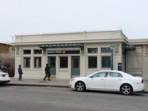
The MTA seems to have built new walls in front of the old ones. The Avenue U station, where I exited the train, has two bridges crossing the tracks at Avenues T and U, and the station sections over the tracks have gotten new windows allowing you to look up or down the tracks depending on what exit you use.


Sally Gil created the artwork for the Avenue U station on the Sea Beach, depicting historic scenes in New Utrecht and Gravesend, including a typical BMT Sea Beach station. Historian Joseph Ditta explains in the Gravesend Gazette.


Though there’s been a lot of coverage of Heins & LaFarge’s subway station design in the heart of the Beaux Art era in the subways’ Original 28 stations in 1904, and the ones built up to 1908 when they bowed out, Heins & LaFarge’s protege and successor Squire Vickers is less well-known; he designed IRT, BMT and IND stations up to 1940, and came up with the original Machine Age IND streamlined designs.
He also designed the station houses for open cut and grade BMT stations on the Brighton (B,Q) West End (D) and Sea Beach (N) lines, as well, and now that they’re being rehabilitated I’ve come to respect and appreciate their designs with beige tiles and green/gold geometric shapes. To me these stations, most of which are on the Sea Beach, are worthy of NYC Landmarks status.


While the Bari pork store or salumeria at Avenue U and West 7th Street has shuttered, its Bensonhurst counterpart on 18th Ave. is still thriving. Both have painted “King of the Sausage” animal cannibal signs. Both Bensonhurst and Gravesend have been heavily Italian-American in the past, but recent immigration from northern Europe and the far East have added to area flavor in recent years.

Walkup apartments with storefronts and stoops, like this pair between West 8th and 9th, are uncommon on Avenue U, which is a mostly commercial route.
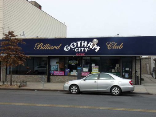
While billiard parlors in other parts of NYC have not been doing well the last few decades, Gotham City, named for the fictional town Batman patrols in the comics, hangs in.
A hand-carved, Italian table with webbed pockets signals to the uninitiated they have entered a players’ pool hall. The owners re-felt the sixteen tables twice a year in a vibrant blue. Shooters can keep score the old-fashioned way, with custom-made scoring beads that hang in front of movie art from The Hustler and The Color of Money. Gotham City exudes an element of class. And this being Bensonhurst, it’s the only place where you can get an espresso while you’re playing. [Brokelyn]


Heading south toward my lunch destination I couldn’t help but notice Lake Place, which is an original Gravesend route dating from before the prevailing street grid was constructed. West of the Sea Beach cut, it’s a public street open to all; east of it, over the past 20 years it has been privatized as a driveway by local property owners. Here is its full story in FNY.


L&B Spumoni Gardens has been a Gravesend mainstay since the 1930s when its founder, Italian immigrant Ludovico Barbati, purchased the space on 86th Street between West 10th and 11th Street. The restaurant as currently configured was constructed in the 1950s. At first, the Gardens sold just desserts and ice cream, but later became famed for its Sicilian-style thick crust pizza in which the cheese goes on top of the crust and the tomato sauce on top of the cheese. The Barbati family continues to operate the venue. Like Many Italian restaurants, there’s a sit-down dining room and a pizzeria on the side serving slices or in the Garden’s case, squares.
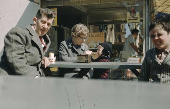
When I was quite little my parents and I took a ride to southern Brooklyn where we sat outside and had ice cream, despite the brisk weather as I remember it. Of course my two-year-old mind did not register if this was Spumoni Gardens, but the setting seems right. I think I have another photo someplace that shows more of the patio. This photo is from about 1959 or 1960. Note the old man’s brown transistor radio.
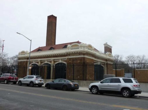
Beaux-Arts pumping station, 86th Street and Avenue V. Southern Brooklyn and especially Gravesend is quite marshy and was shot through by streams before and after the colonial era. As it became more built up, much of the water needed to be removed; this pumping station appears to have been constructed in the very early 1900s. A few years ago, it was given a thorough rehab and is probably the handsomest sewage-associated building in the borough.
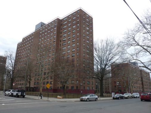
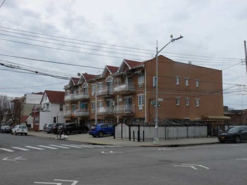
The wedge of Gravesend below the “V” formed by Bay Parkway and 65th Street was once called Marlboro in an era when there were still major racetracks in the region. The development was founded by the Brooklyn Development Company in the early years of the 20th Century and followed the Brooklyn convention of “sophisticated” British-sounding names to impart gravitas. The name “Marlboro” survives in Marlboro Playground at West 11th Street and Avenue W, and the Marlboro Houses, shown here, between 86th Street and Avenue X and East 8th and 11th Streets.
More lost neighborhoods of Brooklyn and Queens
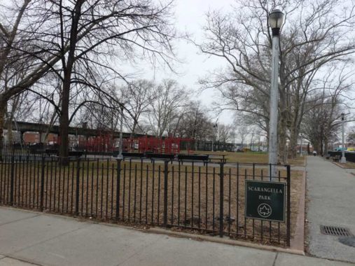
Scarangella Park, the largest park in the immediate area, between Stillwell Avenue, West 13th Street and Avenues U and V, was built in 1930 and was formerly known as Lafayette High School Park until the 1980s, when it was named for Police Officer John Gerard Scarangella (1940-1981) who grew up in Gravesend and was murdered while on duty in 1981. The park’s NYC Parks profile gives a capsule history of Gravesend.
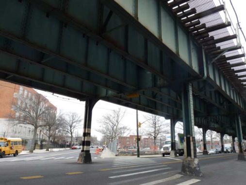
The elevated train tracks over Stillwell Avenue conduct the MTA’s D train, known in the old days as the West End Line, south to Coney Island. The West End began as a steam railroad in the 1800s and was electrified and placed on an elevated line in 1916. In 1972 this stretch of Stillwell Avenue, as well as parts of 86th Street and New Utrecht Avenue, was the site of one of the greatest car chase scenes in movie history as Gene Hackman’s Popeye Doyle chases a subway train that has been hijacked by a French drug dealer in The French Connection.
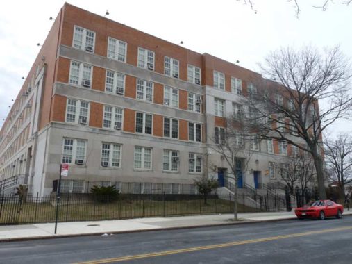
Lafayette High School, Benson and Stillwell Avenues, was named for the Marquis de Lafayette, the French nobleman who provided key military assistance in the Revolutionary War. The school was built in 1939; notable alumni are singer Vic Damone, actors Rhea Perlman and Steve Schirripa, talk show host Larry King, and a number of major league baseball players including Sandy Koufax and John Franco, and New York Mets owner Fred Wilpon.
This cluster of attached homes was built on Bath Avenue and Beach 43rd Street about 2000. Why am I showing them here? They replaced an earlier group of homes built by Moses and Jerome Horowitz, who later attained fame as the Three Stooges. One of the Stooges’ homes, the white peaked-roof building at left, survives today.
Bath Beach was so-called for the British spa town and originally settled in the late 1800s by Brooklyn’s nabobs and elite as a suburban playground, with villas, yacht clubs and mansions. Most of the mansions have disappeared and the few Victorian-era homes have been stripped of most of their appointments.

The Ulmer Park branch of the Brooklyn Public Library is named for an amusement park and beer garden opened in 1893 at the Bath Beach waterfront along Gravesend Bay by German immigrant beer baron William Ulmer as competition for Coney Island, but the venture never took off and it was closed by 1899. “Ulmer Park,” though, has inordinately survived as a place name, giving its name to a bus depot a few blocks away at Bath and 25th Avenues and this library.
The Ulmer Park branch of the Brooklyn Public Library is named for an amusement park and beer garden opened in 1893 at the Bath Beach waterfront along Gravesend Bay by German immigrant beer baron William Ulmer as competition for Coney Island, but the venture never took off and it was closed by 1899. “Ulmer Park,” though, has inordinately survived as a place name, giving its name to a bus depot a few blocks away at Bath and 25th Avenues and this library.
Born in Wurttemberg in 1833, William Ulmer immigrated to New York in the 1850s to work with his two uncles, Henry Clausen Sr. and John F. Betz, in the brewing industry, eventually becoming the brewmaster for Clausen’s very successful New York firm. In 1871, Ulmer partnered with Anton Vigelius to form the Vigelius & Ulmer Continental Lagerbier Brewery on Belvidere and Beaver Streets in Bushwick, Brooklyn. Born in Bavaria, Anton Vigelius immigrated to Brooklyn in 1840 at the age of 18 and was involved in the produce business prior to opening the brewery. He purchased land at the corner of Beaver and Belvidere Streets from Abraham and Anna Debevoise in 1869. In 1877 Vigelius sold his share of the brewery to Ulmer. The building ceased to be used as a brewery at the dawn of Prohibition in 1920. Though compromised by time, its arched windows and details such as tie-rod caps stand the test of time. Currently awaiting true renovation, it’s home to offices and light manufacturing. Local “street artists” continue to tag its bottom floors.
Both the Ulmer brewery and offices still stand in the Bushwick Avenue area!


Here’s the bus depot which has a leftover ancient sign: “Caution! turning machinery,” referring to the mechanical processes of turning and lathing.


Bensonhurst’s Salvatore Guaragna became one of the great songwriters of the early 20th Century under his adopted name, Harry Warren (1893-1981). Much of the music in the Broadway smash “42nd Street” is his, as well as songs like “We’re in the Money,” “I Only Have Eyes for You,” “Lullaby of Broadway,” “Jeepers Creepers,” “You Must Have Been a Beautiful Baby” and many others with Al Dubin, Johnny Mercer and others.
A community theater, home to the Ryan Reportory Company, is named for him at Bath Avenue and Bay 38th Street.
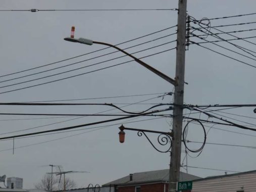
Bath Beach formerly had a number of old-style scrolled fire alarm lamp brackets. These seem to appear in clusters around town; I’d estimate there are between 50 and 100 remaining in three boroughs (I’ve spotted none in Manhattan or Staten Island).


In Brooklyn can be found many of the great languages devised by Man. On this stretch of Bath Avenue alone you find Arabic (in Roman lettering), Mandarin Chinese, Greek, and Russian.
And now for a bit of mystery that I need solving. What we’re looking at is The westbound Exit 5 of Shore Parkway at Bay Parkway. The road is one-way westbound, and connects Shore Parkway and Bay Parkway directly — this isn’t the Shore Parkway service road at all.
So what are those six attached homes doing there? what are they doing on what is essentially the Belt Parkway? They can only be approached, in a vehicle, from the westbound Belt Parkway.
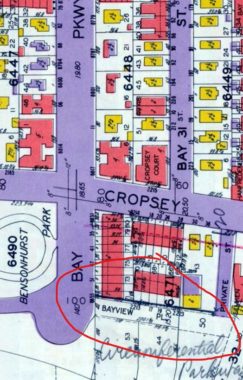
The answer is that they were originally on a short street called Bayview Place. The attached houses were part of a real-estate complex that faced Bayview Place, Bay Parkway, and Cropsey Avenue; the ones on Bayview Place survive, while Bay Parkway’s were razed decades ago. There are still a couple of them on Cropsey. [Map, Belcher-Hyde, 1929]
In 1938 the Circumferential Parkway was built through the area, since renamed the simpler Shore Parkway or Belt Parkway. Bayview Place was incorporated into the westbound Shore Parkway service road, and in later years it was separated from the rest of the service road, which dead-ends west of 24th Avenue.
So how do residents of these homes approach it in their vehicles? They’d need to get on the Belt Parkway at Bay 50th Street and drive about a mile west to here. Obviously that’s not the solution. There may be a driveway from Cropsey Avenue, but I don’t see it on Street View. Local residents, fill me in on this perplexing situation.
I seem to recall reading somewhere (it’s not in Robert Caro’s The Power Broker) that traffic czar Robert Moses tried to get the owners of these homes to sell to make way for the Belt Parkway in the 1930s, but they refused — so Moses built the Belt Parkway right in front of them, out of spite. Again, I can’t confirm this.


Bensonhurst Park is the largest park in either Bath Beach or Bensonhurst (much of Dyker Beach Park is taken up by the golf course), running between 21st Avenue and Bay Parkway and from Cropsey Avenue past the Belt Parkway to the bike path at the water’s edge. (The Belt parkway bike path ends here, forcing bikes onto the streets through Coney Island and Sheepshead Bay before resuming at Knapp Street. Past that point, it was an overgrown, broken-glass-strewn travesty, until 1993, when I moved to Queens. Then it was rebuilt!)
The city of Brooklyn purchased approximately 16 acres of land from the Benson and Lynch families in 1895 for Bensonhurst Park. There are still some older wood and concrete benches here and there.
In the Swingin’ Sixties my parents and I would pass the park on our periodic visits to E. J. Korvettes Department Store, which was at the end of Bay Parkway. After Korvettes went bankrupt and closed in 1980 the store became part of the Caesar’s Bay mall. Bensonhurst Park was also the southern end of my bike trips along Gravesend Bay and the Narrows. The northern end of the bike path is at the old 69th Street ferry pier. Eventually the city intends to connect the bike paths all over Brooklyn’s waterfronts, but how this will be engineered is anyone’s guess.
We would take the B64 bus from 86th Street to Bay Parkway and Bath Avenue and walk to the end of the parkway. In 2010 the B64’s route was dramatically changed and it now runs from Shore Road and 71st Street to the Ulmer Park bus garage on 25th and Cropsey (see below); it no longer runs to Coney Island, as it did for countless years. There is no longer a direct bus route from the 86th Street shopping district in Bay Ridge to Coney Island; your best bet is now the B1 down 86th Street and transfer to the B82 at Bay Parkway.
Bensonhurst Park is considerably less dull in spring and summer. Remember, this was the dead of February. Before the Belt Parkway was built, the park had a clear view of Gravesend Bay.

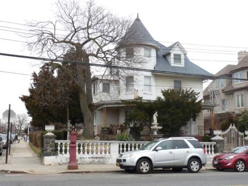
How to ruin a perfectly good Victorian. This is 2111 Crospey Avenue, whose owners recently gave it the Treatment: a bland beige stone exterior and a paved lawn. Things used to be considerably livelier at this place…
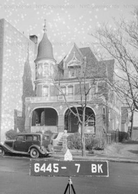
…since in 1940, it was still in full Victorian splendor. Successive owners have chipped away at this grandeur.
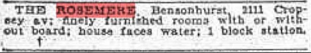
An old Brooklyn Eagle listing has it as the Rosemere, operated as a boarding house or hotel.


In this Gallery, I’ll just show you a sampler of buildings along the north side of Cropsey Avenue between about 18th and 21st Avenues. Bensonhurst isn’t known for architectural splendor, but these buildings have plenty to recommend them at least the exteriors. There are some fascinating detailings!


A pair of remnants from the days when the Department of Transportation marked honorary street names with blue signs; beginning in the 1990s, regular green was used. 16th and 18th Avenues are named for a pair of Italian personages; Christopher Columbus, of course, sailed under the Spanish flag in 1492, seeking a shortcut to India, but wound up in the Caribbean instead, touching off centuries of western conquest.
Native Neapolitan Vincenzo Scognamiglio immigrated with his parents to Brooklyn at a young age. He got the acting bug and changed his name to the easily pronounceable Vincent Gardenia (1920-1992). He was a familiar staple on TV and in movie theaters in the 1970s and 1980s. His most remembered roles were the New York Mammoths manager in Bang the Drum Slowly, Detective Frank Ochoa in Death Wish, Mr. Castorini (Cher’s character’s father) in Moonstruck, and blustering but friendly Archie Bunker neighbor Frank Lorenzo. He was a longtime Bath Beach resident.
Here’s another (formerly) grand building on Bay 10th and Cropsey. Different people have different tastes, but IMO the view of the house has been ruined by that oppressive columned fence surrounding the property. These cheaply-made fences are going up all over town as homeowners apparently believe they add a touch of class (undoubtedly believing whatever the sales rep at Home Depot tells them). The fence is labeled “Villa Regina.”
Large homes and plots are now unusual in Bath Beach and so this brick house at 15th Avenue and Cropsey stands out. There are certain clues you can look for in New York City if you’re wondering how old a neighborhood is, or how old a house might be, and one of them is the presence of bluestone sidewalks. This handsomest variety of NYC walkway has not commonly been installed since the 1910s.
A dental practice occupies some of the building, and the late Dr. Michael Brienza is honored with a street sign. It’s a new sign and reflects the current trend away from Highway Gothic and toward Clearview on street and highway signs. Lowercase letters, rarely seen previously on NYC signs, also make an appearance.
Cropsey Avenue itself was named for German immigrant Casper Crepser, who arrived in New Utrecht in the 1700s. His descendants changed their name to Cropsey; they include Hudson River School painter Jasper Cropsey (whose painting “Looking Oceanward from Todt Hill” has its point of view recreated in the Cropsey Overlook in Todt Hill, Staten Island) and murderer Andrew Bergen Cropsey, who killed his wife in 1908 in Bath Beach.
Cropsey Avenue begins at 14th Avenue and Poly Place across from Dyker Beach Golf Course and runs generally southeast. The Department of Transportation has finally decided on Poly Place as the name of the road that runs along the southern border of Dyker Beach Park between 7th and 14th Avenues. For decades, the road was unnamed, leading some to call it Poly Place and others, Cropsey Avenue Extension. {info via Leonard Benardo and Jennifer Weiss’ Brooklyn By Name]
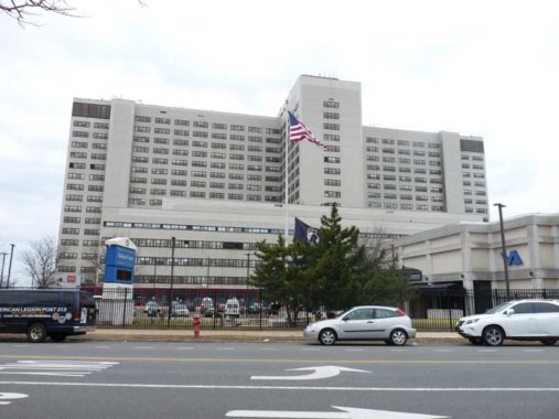
The Brooklyn Veterans Affairs Healthcare System hospital, 800 Poly Place near Fort Hamilton, has been a Bay Ridge staple for a long time, but I know little of its history, even when it was built. When I was a kid, we would bundle up used magazines and bring them down there so the soldiers in treatment would have something to read while hospitalized. Years later, when I worked nights, I would come home in the early morning, crossing the Gowanus Expressway on 72nd Street or 7th Avenue. I would look south to see the big red tree in Christmas lights on the hospital in season.
I’ll leave it here and cover the conclusion of my trip into Bay Ridge next time.
Check out the ForgottenBook, take a look at the gift shop, and as always, “comment…as you see fit.”
3/10/19
9 comments
“These cheaply-made fences are going up all over town as homeowners apparently believe they add a touch of class (undoubtedly believing whatever the sales rep at Home Depot tells them).”
The sales rep doesn’t say anything, I can speak from authority on that. In fact we generally hate dealing with fencing, as more often than not it’s necessary to remove multiple panels off each stack (a physically demanding task) before the customer sees one that’s _maybe_ good enough for him. Bah!
On a wholly different note, while L&B sounds fine I’d be intrigued by the Lights of Baku next door. Their menu shows such curiosities as quails in dried fruit sauce, sturgeon shish kebab and eels baked in red wine sauce.
The Sea Beach mosaics are by Sally Gil. There are tablets on columns of each platform identifying them.
http://gravesendgazette.com/2018/11/19/sally-gils-gravesend/
Thank you. I love this. I just heard of Bath Beach and it fascinates me.
The B64 returned to Coney Island in January 2013, it currently runs from the Xavarian School at Shore Rd and 71st St to Stillwell Terminal
The Sea Beach station murals at Avenue U are by artist Sally Gil: https://gravesendgazette.com/2018/11/19/sally-gils-gravesend/?fbclid=IwAR1XFBWmhbcZgrfUtjCun_tKbBF8bnTQQtnWRBeoZIxcQwtuIimdO1_An_g
Should note that according to the link shown (www.nycsubway.org), the West End Line was electrified in 1893 using overhead trolley wire. The electric trains operated along New Utrecht Avenue’s surface, until the elevated structure was built, as noted, in 1916. The elevated was part of the vast Dual Contracts subway expansion built between 1913 and 1931. The Dual Contracts work included the West End Elevated, Fourth Avenue subway, Manhattan Bridge trackage, and the Broadway subway in Manhattan. Combined, these routes gave the West End and its sister routes to and from Coney Island direct subway service to and from Midtown Manhattan, replacing the older elevated routes that crossed the Brooklyn Bridge and had a single Manhattan station at Park Row.
The West End line is so named because it originally terminated at the “west end” of Coney Island, where today’s Stillwell Avenue terminal is located. The other Coney Island railroads originally terminated closer to today’s West 8th Street Station. Since 1919, all four have terminated at the current Stillwell Avenue complex.
Interesting that your row houses are on Bay View Place in the tax file photos, but are on Shore Parkway in the DOB files (Brooklyn block=6471, Ex. 1623 Bay View Place = 1623 Shore Parkway today).
Interesting that your row houses are on Bay View Place (Brooklyn block=6471) in the tax files but are on Shore Parkway in the DOB files (ex: 1623 Shore Parkway).
In the late 50’s I attended a summer day camp at Lafayette HS. Many of the activities were held on the fenced in roof. Later in the early 60’s, I went to New Utrecht HS, which was considered inferior to Lafayette academically, and more violent. Jump ahead 50 years and Lafayette is essentially closed due to low academic results and high violence, while New Utrecht is still going strong and rated in the top 20% of NYS high schools! Kevin, let’s have a shout out for New Utrecht. We may not have as many famous alumni, but we’re survivors!
Vincent Gardenia also played the father in the movie Moonstruck.