
What to do when two streets in the same borough have the exact same name? Nothing much, but it’s a rarity in New York City. This is deliberate. The opposite used to be the case. Before four New York State counties were combined to form Greater New York City in 1898 (the fifth county, the Bronx, was separated from New York County in 1914) the counties were made up of individual towns: in Kings, there was the city of Brooklyn, Bushwick, Flatbush, New Utrecht etc.; by 1895, they had been absorbed into the then-City of Brooklyn. In Queens, there was Newtown, Flushing, Jamaica et al. Probably the least known of these towns were in Staten Island, which featured the towns of Southfield, Northfield, Castleton etc.
After Greater New York was formed, the towns were dissolved as the counties became boroughs. However, street names could be duplicated in more than one of these towns. Every town could have a Washington Street, a Spruce Street, etc. Post offices were confused. It was then that city management decided to rename the streets so that these duplications could be eradicated. The form of these changes differed by borough. Between 1912 and 1930, Staten Island renamed most of its streets, and duplications were avoided for the most part. While some main roads were unchanged, Richmond Turnpike (established by Vice President Daniel Tompkins in the early 1800s) became Victory Boulevard while Fresh Kills Road became Arthur Kill Road.
Queens was a different story. That borough’s Topographical Bureau numbered all the streets — and created even more problems in neighborhoods like Maspeth where it seems every street is numbered 59 or 60.
In Brooklyn, most of these duplications were caught and changed. However, there’s still a decent amount of street name duplications — I’ll discuss them here.
Manhattan Avenue, Williamsburg-Greenpoint and Manhattan Avenue, Sea Gate

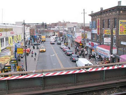
Manhattan Avenue runs in a general north-south direction from Brooklyn’s Broadway north to Newtown Creek; it forms the heart of Greenpoint and is the main north-south shopping street. It’s been called Manhattan avenue for only 120 years or so; before that, parts of it were called Ewen Street and Union Avenue. It seems the height of deference for a Brooklyn route to be named for its rival across the East River. Can you imagine a main drag in Manhattan named for Brooklyn? I don’t think so.
While Manhattan itself has a Manhattan Avenue, its two Manhattan Streets have all but vanished. Manhattan Street was renamed 125th Street, and a shorter Manhattan Street ran along the west edge of PS 188 north of East Houston Street. Letters on the building identify it.
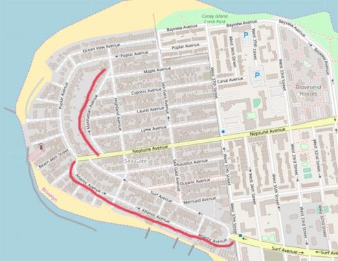
In Sea Gate, the private community west of West 37th Street in Coney Island, things are so secretive that even the Google Street View truck is not allowed in. The walled-off enclave has its own Manhattan Avenue which curves from Neptune Avenue to Highland Avenue.
Atlantic Avenue, Brooklyn Heights-Woodhaven and Atlantic Avenue, Sea Gate
Similarly, one of Brooklyn and Queens’ longest avenues has a “twin” in Sea Gate. Atlantic Avenue when first laid out in Brooklyn Heights was called District Street, then Atlantic Street, but as it was extended east along the LIRR surface tracks, it became an Avenue. Atlantic and Pacific Street weren’t named for the oceans: Atlantic, for the Atlantic Dock Company and Pacific, for the Pacific Stores, which housed imported goods at the 19th Century waterfront.
West Street, Greenpoint and West Street, Gravesend

West Street’s name in Greenpoint is pretty easy to explain: it’s the westernmost north-south street in the neighborhood, and the street closest to the East River. But what about…

…West Street in Gravesend, which runs from Avenue T south to the Belt Parkway between East 1st and West 1st Streets? Well, it is west of something, in a matter of speaking.
Gravesend uses the street numbering system that was designed for Flatbush, with north-south oriented streets running east and west of Gravesend Avenue, renamed McDonald Avenue in 1930. Actually McDonald Avenue stands in for East 1st Street north of Kings Highway, while Dahill Road is the longitudinal “0 Street.” However, McDonald Avenue zigs to the southwest south of Kings Highway and so, an East 1st Street was laid out to take its place, and west of that, Dahill Road was replaced by West Street — which sits to the west of the East numbered streets.
Confused enough? South of the Belt Parkway, an east-west road called West Avenue runs past Lincoln High School.
West 9th Street, Red Hook and West 9th Street, Gravesend

West 9th Street is on the outskirts of Red Hook at the south end of Carroll Gardens and is a literal western extension of 9th Street, running from Smith Street west to Columbia Street. Maps made before about 1900 show it as Church Street.
The first 9th Street bridge crossing the Gowanus Canal was completed in 1905; in 1999, the bridge reopened after a complete renovation. In the 1930s, a massive railroad trestle carrying the IND subway was built over it. My educated guess why Church Street became West 9th is that the city wished to continue 9th Street further west after the bridge opened in 1905, but didn’t want to renumber all the houses on the street all the way to Prospect Park, which they’d have to do. So, West 9th Street it was.

West 9th Street, meanwhile, parallels its brothers West 8th and 10th Streets, running from Bay Parkway south to 86th Street. Like the West streets, the West 9ths are so far apart that no one except people new to Brooklyn gets confused about them.
Stewart Avenue, Bay Ridge and Stewart Avenue, East Williamsburg

How the mighty have fallen! Stewart Avenue, now reduced to a few interrupted unpaved blocks between Ovington Avenue and 74th Street, was in the 19th Century a main north-south drag in Yellow Hook, part of the town of New Utrecht. When Yellow Hook became Bay Ridge and street grid was imposed on it, Stewart Avenue lessened in importance and gradually faded.
I have the full Stewart Avenue story on this FNY page.

Stewart Avenue was laid out in the 19th Century as a continuous north-south avenue running between Flushing and Meeker Avenues in East Williamsburg, a couple of miles at least. However, the entire road was never built as laid out; the English Kills interrupts it, as well as the vast East Williamsburg Industrial Park.
As with other Brooklyn Duplicates, the two Stewart Avenues are miles and miles apart and no one mistakes one for the other, except for a few Uber drivers who are new in town.
Ford Street, Sheepshead Bay and Ford Street, Crown Heights

With a pleasant, almost sleepy collection of postwar freestanding and attached dwellings, Ford Street looks pretty much the same as it did in the 1930s and 1940s, when the homes were built. It runs between Gerritsen and Emmons Avenues, interrupted by the Nostrand and Sheepshead Park Houses, and the Frank Macchaiarola School and Athletic Field, between Avenues V and Y.
Meanwhile, there’s a short two-block street also called Ford Street running from East New York Avenue north to Carroll Street just west of Rochester Avenue at the east end of Crown Heights, near Lincoln Terrace Park. It’s a remnant of a small village called Pigtown: the Essential Montrose Morris has the scoop in Brownstoner.
Ford Street likely survived because it runs along the back end of some massive apartment complexes, and the developers found it convenient to keep some rear entrances.
Cedar Street, Bushwick and Cedar Street, Midwood
Both Cedar Streets run for one or two blocks. In Bushwick Cedar Street runs between Bushwick and Central Avenues, crossing under the el at Myrtle Avenue.

Meanwhile, in Midwood, another Cedar Street runs between East 16th and 17th Streets south of Avenue M. This Cedar Street was part of a much older Kings County small town called South Greenfield, which has left its traces in against-the-grid streets like Chestnut, Locust, and Bay Avenues.
I have South Greenfield’s story on this FNY page.
The two Sheepshead Bay Roads

In Sheepshead Bay, there are two separate Sheepshead Bay Roads, separated by about one mile. One branches off from Neptune Avenue at West 8th, coming to an end at the Culver El at West 6th (where there’s an interesting McDonalds that still employs Ronald McDonald’s predecessor, Speedy).
The other Sheepshead Bay Road runs generally northwest from Emmons Avenue, petering out at Gravesend Neck Road at West 12th Streets.
While they’re separated now, these two Sheepshead Bay Roads were once joined, with the missing section running along the now-vanished Brighton Beach Racetrack. The sections were separated as early as the 1880s, with 130 years’ worth of changes along the interim territory since. Emmons Avenue assumes some of the path of the connecting section.
I’ve probably forgotten a few! Fill me in in Comments.
Check out the ForgottenBook, take a look at the gift shop, and as always, “comment…as you see fit.”
10/31/19
18 comments
As you may know, you and I have a common interest in street names. I’m grateful to you for doing the research to enable me to learn about things that otherwise would be unknown to me.
There is a Lee Avenue in Williamsburg and a Lee Avenue in Fort Hamilton.
Not counting forts and cemeteries
Staten Island has two Hanover Avenues, one in 10304 and one in 10309.
Ford Street was a street in a long gone planned community called Oakland in the mid 19th century Pigtown was further west by several blocks…
There is Stewart Street off Bushwick Avenue hard by the cemetery by the entrance to the Jackie Robinson,as well as a Stuart Street that runs from Nostrand Avenue to the Gerritsen Beach. Lived on the later, occasionally got perplexed calls from delivery guys who made the mistake of going to the former.
I mean multiple Stewart Avenues, not all streets named Stewart.
Ford Street in Crown Heights was named for Laura A. Ford, through whose land the street was laid out. Ford Street in Sheepshead Bay was named for one A. L. Ford, a member of the engineering staff for the Kings County Town Survey Commission, which between 1869 and 1875 laid out the street grids in the Towns of Flatbush, Flatlands, Gravesend, New Lots and New Utrecht.
And a couple more: Cypress Avenue, Bushwick and Cypress Avenue Sea Gate. Oceanview Avenue, Brighton Beach and Oceanview Avenue Sea Gate.
While not precisely on point, the way the City of Brooklyn dealt with redundant Henry Streets merits a brief comment.
When Bushwick was annexed into Brooklyn in 1855, there was a Henry St. in the Greenpoint section of this town. This, of course, duplicated the Henry St. situated in Brooklyn Heights. The City Fathers got around this by renaming the Greenpoint St. North Henry Street. As there is no corresponding South Henry St. anywhere in Brooklyn, this was the only reason for this action. I happened to live on this street for about 15 years.
Major North South Avenues like Bedford, Washington intersect with similar named streets:
Lincoln Road and Lincoln Place
Sterling Street and Sterling Place
Park Ave and Park Place
Lefferts Ave and Lefferts Pl
Franklin Ave intersects with Greene Ave
Franklin Street intersects with Green Street
There’s also
No I mean streets with EXACTLY the same name, including Street, Avenue, Place etc
Let’s not forget that unit almost 1900 Brooklyn was only part of Kings County just like how NYC used to just be part of NY County until the late 1800’s, which might explain why some streets are duplicated., though I would assume that the original city of Brooklyn was most likely Downtown, Brooklyn Heights, and Fulton Ferry with some possible ones bordering them.
And the east whatever number streets in Manhattan & brooklyn
Sheepshead Bay Road peters out at Gravesend Neck Road & EAST 12th Street.
Dahill Road runs in a few separate sections, including one at 47th street and 19th Avenue that is so short that it only has 2 houses on it!
True, but I mean completely different streets with the same name. Plenty of streets are interrupted in spots.
Bunch of broadways, on in queens, one in Brooklyn, one in Manhattan(5 if you found North West East and South Broadway)
Ocean ave “north” and then the little extra part that picks up again when you cross the bridge at E. 16th? And then ocean ave starts again down towards kingsborough CC.