It’s amazing, to me at least, how Queens subway stations preserve street names and family names that, in some cases, go all the way back to the colonial era. Names that have not been used for nearly 100 years can be found on the IRT Flushing Line and the BMT Liberty Avenue El, as well as the IND Far Rockaway Line. Until recently, stations along the BMT Astoria elevated also had traditional names but they were removed as part of an ongoing renovation program that began in 2017.

One station along the IND Crosstown Line (G) which runs mainly in Brooklyn also sports a name harking back to the earliest days of settlement in western Long Island in what ultimately became Long Island City before Queens County joined NYC in 1898. It’s the Van Alst-21st Street station, the penultimate station on the line before its end (since 2010) at Court Square. (Tracks that are unused for revenue service do connect it with the Queens Boulevard line.)
The Van Alst-21st Street station was built (opened in the 1930s) in somewhat marshy territory cleaved by underground streams, and water is constantly dripping into it, compromising the station tilework and rendering it one of the ugliest, least-maintained stations in the system. Just think, though — this would have been the station closest to the Olympics complex NYC was planning that would have been built for the 2012 Games (that were awarded to London) and one of the stations closet to the vast Amazon offices complex that the retailer was planning to build in the area before local politics led them to nix the plan.
The name Van Alst does indeed go back to Queens’ earliest days. Joris Stevenson Van Alst was a Dutchman living in Alast, Belgium, in Flanders, before coming to the New World in the 1650s. The family was illustrious as the centuries rolled on. Bergoon Van Alst drove away Loyalists during the Revolutionary War, while John L. Van Alst became a Long Island City schools commissioner in the 19th Century. In 1874 Peter G. Van Alst was a surveyor who graded Jackson Avenue, the western end of Northern Boulevard/Route 25A.
The Van Alst family cemetery was located at Jackson Avenue and Orchard Street. When the area was built up in the 1920s, remains were removed and reinterred in Cypress Hills Cemetery. When the area was being redeveloped in the 2010s, Tishman Speyer enlisted the aid of the New York Times, which found Van Alsts in Boston and North Carolina.
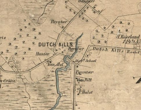
Here’s an excerpt from a Dripps map of Queens in 1852. We can see the Van Alst property in the present-day Queens Plaza, which at the time was near the headwaters of a creek called Dutch Kills. The surrounding neighborhood was named for the Newtown Creek inlet, which was hammered into a canal in the early 20th Century.
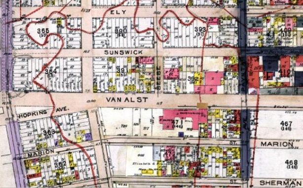
This 1915 map shows Van Alst Avenue in LIC. Beginning in 1915, most of Queens’ streets gained numbers, and by the mid-1920s, Van Alst Avenue had become 21st Street. When the IND Subway arrived in the 1930s, the Van Alst name was appended to the station for the benefit of area oldtimers who still went by the old name.
Here’s some Van Alst Avenue highlights from south to north. 21st Street is one of the lengthiest continuous numbered streets in Queens (along an undivided stretch) along with 108th in Corona and 164th in Flushing.
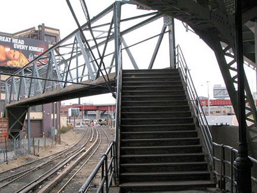
In 1998, I rode one of the final local LIRR trains along the old Montauk Branch connecting Jamaica and Long Island City, when I got off I headed for the subway, buit not before doing a bit of urban exploring. I was fascinated to find this footbridge connecting two ends of 21st Street along at-grade LIRR tracks that connect the LIC station with the main line in Sunnyside Yards.

For the better part of two decades, this classic chrome diner building has been abandoned and collecting dust at the corner of 49th Avenue and 21st, across from the Paragon Building. For a brief period, though, it was the hottest restaurant in western Queens as steakhouse M. Wells occupied the building from 2011-2012; it has since relocated to Crescent Street about a mile away.

PS 1, a Romanesque Revival former public school at 22-25 Jackson Avenue at 21st Street, was built in the 1890s when Long Island City was indeed a real city. In the 1970s it was revived as a contemporary art museum and then began an association with the Metropolitan Museum of Art, housing exhibits that may have been thought too risky or outré for the more stolid MoMA. The museum has cleverly incorporated the old school’s interiors as art spaces, down to the bathrooms and boiler rooms. Older photos show that it once had a corner clock tower.
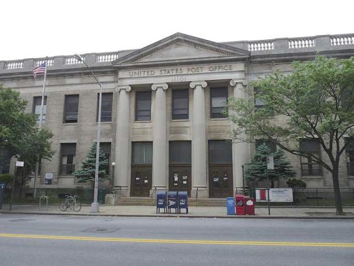
The Long Island City Post Office is a historic post office building located at Long Island City in Queens County, New York, United States. It was built in 1928, and is one of a number of post offices in New York designed by the Office of the Supervising Architect under director James A. Wetmore. The building is a two story, symmetrically massed brick building with limestone trim in the Colonial Revival style. It was listed on the National Register of Historic Places in 1989. wikipedia
The LICPO is somewhat similar in design to the Flushing Post Office, which has a number of interesting murals.

Constructed in 1900 as Grace Methodist Episcopal Church, the Iglesia ni Cristo (INC) or Church of Christ, 21st Street and 45th Road, is the only Christian religion to have started in a so-called third world country (the Philippines) and successfully expanded in the west. The INC has more than 3,500 congregations worldwide in nearly 100 countries and territories. There are more than 38 congregations in the Northeast Seaboard alone.
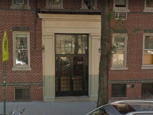
Often apartment buildings in Queens give clues to the former names of the streets they’re on. Van Alst Court, just north of 45th Avenue and its landmarked district was named Van Alst Court when it was built.
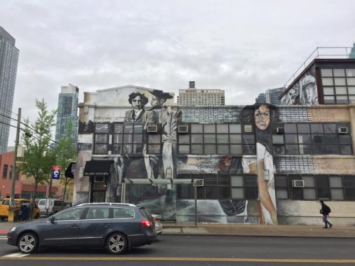
A warehouse at 21st Street and 43rd Avenue since 2018 has been the canvas of a huge mural by graffiti artist Cern. The art wraps around onto 43rd Avenue. I don’t recognize any of the faces, so help me out in Comments.
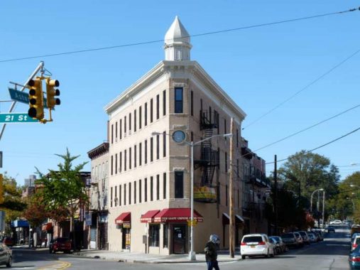
Most of 21st Street runs past auto repair joints and the Ravenwood Houses, so I’m skipping all the way north to Astoria Square, where 21st Street, Astoria Boulevard and Newtown Avenue all come together.
In 1889 L. Gally established a furniture store and built this handsome four-story brick building in the western “V” formed by 27th Avenue and Astoria Boulevard. The furniture store lasted just a few decades, but this distinctive building with its cupola, now overshadowed by a high rise on the opposite side of Astoria Boulevard, has “nonetheless persisted.” It has been nicely restored within the past decade. It’s called Astoria’s Flatiron Building, but the actual Flatiron Building should be called Manhattan’s L. Gally Building — it preceded it by 12 years.
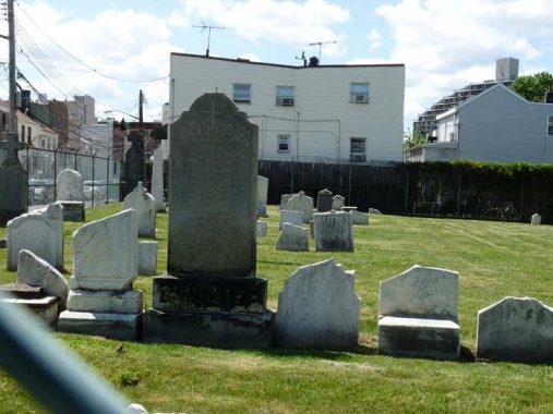
Here’s a friendly neighborhood cemetery at 21st Street (Van Alst Avenue and earlier, Emerald Street) and 26th Avenue, known by locals as the Irish Famine Cemetery, though its grounds are well protected, by a chain-link fence that passing photographers have to shoot through, and well-cared for, by Our Lady of Mount Carmel Church. This is the church’s proprietary cemetery and the church itself formerly stood next to the churchyard, though decades ago it moved to its present location at Newtown Avenue and Crescent Street. It is the final resting place of about 100 early Irish immigrants to Astoria, many arriving after the Irish potato famine of 1847.
Before ending at 20th Avenue, 21st Street passes under approach ramps of both the Triboro and Hell Gate Bridges.
Check out the ForgottenBook, take a look at the gift shop, and as always, “comment…as you see fit.”
3/19/20


8 comments
Never noticed that there aren’t numbered streets in
Queens with much distance associated with them.
21st Street does seem to be the longest. I would have thought 108th Street from East Elmhurst to Forest
Hills would be longer but definitely not. 149th Street
from Whitestone to Flushing looks slightly longer
than 108th and 164th but not longer than 21st.
As a kid when I lived first near 21St and then on it I heard the name Van Alst and wondered what that was all about. Then one day I saw Van Dam st and after that the Van Idersteen company on Review ave. it was then I realized the Dutch influence in the area. But funny, off the top of my head can’t think of any other original street names in LIC-Astoria-Sunnyside with Dutch type names. Does anyone else?
There’s a Van Loon and Van Horn towards Woodside/Maspeth.
On the 1908 Belcher Hyde Map, there is a Van Alst St. shown between Grand St. (now Grand Ave) and Thomson Ave. (now Queens Blvd.). Today that road is
known as Van Loon St. On the same map, there is an Adams St. which is known today as Van Horn St. Adams St. looks like it ended at about Weimar St (today 54th Ave), and at some time was extended to intersect Grand Ave. My Grandmother lived at 85-30 Grand Ave from the late 1950’s to the late 1970’s or so. Her
building was knocked down some years ago, but the house next door is still there, but hard to see as it is tucked back from the sidewalk now. On the same map, there is no Simonson St or Codwise Place and Kneeland Ave was called Calamus Road. My uncle lived with either his parents or grandparents on Kneeland Place somewhere between the 1930’s and 1940’s.
Correction on my post. Should read “On the same map there is no Simonson St or Van Kleek St…). On the 1908 map, there is a Dewey St, which today is
Codwise Place.
The history of the Van Alst family is very interesting, I’m a descendant, a lot of my family lived close to Montgomery in Orange County, my Grandfather moved to Ohio after WW1 remaind in Indiana where most of my family is today.
My Grand father came from thir my son lives thir now I go thir quiet often as well
My birth name was Mary Ellen Van Alst in March 1959. I was placed in Angel Guardian Orphanage in Queens NY. Would love to know more on my history