

As most Forgotten New York readers know, I enjoy maps, especially historic ones that show what the streets of NYC looked like in previous decades. Today, I’ll review an outline map of Queens I saw posted on Facebook by Todd Berkun. This outline map is actually part of a larger Hagstrom map that shows Brooklyn, Nassau and Suffolk counties, and appeared in maps and atlases of Nassau and Suffolk, way into the 1980s and perhaps even up to when Hagstrom digitized their maps, giving them a more boring design, in my opinion, in the late 1990s. I like the Trade Gothic and Century typography. If you’re curious about what Queens map was in 1922, I have an online version here.
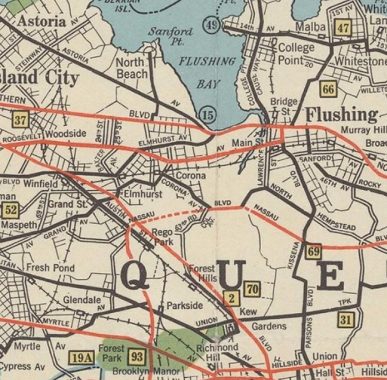
The landscape in Queens was quite a bit different back in the 1920s and into the 30s. No expressways existed, and even parkways were just beginning to get started. Autos had to depend on local streets to get around. At this time, Queens’ borough-wide street and house numbering system was still being changed over, and in spots, some older names and numbers were still there.
On the north shore, before LaGuardia Airport opened in the late 1930s, the area was an amusement area and resort called North Beach. What I didn’t know was that it was called Sanford Point. Two of the main north-south streets are marked 24th and 25th Streets; today they are 81st and 82nd.
There were more railroad stations, and even some branches have closed. The LIRR Montauk branch still ran a few trains to Long Island City up to March 1998. The Glendale, Fresh Pond and Haberman (out of the picture on the left) stations closed. The Rockaway branch from Rego Park closed in 1962, along with its Parkside and Brooklyn Manor stations. In Flushing and Whitestone, the Whitestone Branch shut down in 1932, taking its Flushing-Bridge Street, College Point, Malba and Whitestone Landing stations with it. On the main line, the Winfield and Grand Street stations disappeared long ago.
In Flushing, much of College Point Boulevard was called Lawrence Street, for the prominent local family, until 1969.
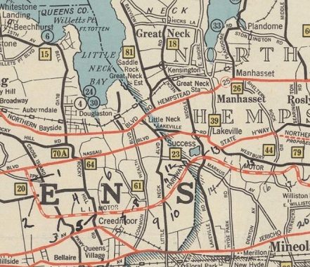
It’s in eastern Queens that many of the street names have changed. Nassau Boulevard was constructed as a direct route from Queens Boulevard into Nassau County; it was renamed Horace Harding Boulevard for a commissioner crony of Robert Moses’ in the 1930s, and when the Long Island Expressway was built in the 1950s, its service roads took over the Horace Harding name. It isn’t called the Long Island expressway proper until the road enters Nassau County; a small bit of Nassau Boulevard still breaks off, crossing Little Neck Parkway into Nassau.
When the Cross Island Parkway was built in 1940, rather than avoid confusion with Cross Island Boulevard, that road was renamed Francis Lewis Boulevard for a local Declaration of Independence signer; its northern end became Clintonville Street, as early NYS governor, senator and NYC mayor DeWit Clinton “summered” in northern Queens.
Rocky Hill Road, which only runs for a couple of blocks in modern-day Fresh Meadows, used to be a lot longer, encompassing parts of 46th Avenue, Bell Boulevard and Braddock Avenue.
The Long Island Motor Parkway, an early auto through route, was built from the Nassau Line to Ronkonkoma in 1908 and extended west into Queens in 1926, closing in 1938 after competition from the new Grand Central Parkway. It can still be seen here on this 1930 map.
In 1930, Northern Boulevard stopped at the Nassau line, and what became Route 25A was called North Hempstead Turnpike, as it ran through that Nassau County town. By 2020, most of it up to the Suffolk County border is called Northern Boulevard, though you still see some NHT signs as you get near Suffolk along 25A.
Ah but there was another North Hempstead Turnpike, renamed Booth Memorial Avenue (for the founder of the Salvation Army William Booth; the hospital is now part of the New York Hospital system) in the 1960s.
Little Neck Parkway underwent some permutations, from Old House Landing Road to Little Neck Road to Little Neck Boulevard to Little Neck Parkway. Since there were two Lakeville Roads, the one running east to west was changed to Bates Road. Markus Avenue lost a K and obtained a C. Commonwealth Boulevard is still there, but a lengthy part of it became Marathon Parkway.
Check out the ForgottenBook, take a look at the gift shop, and as always, “comment…as you see fit.”
12/2/20
12 comments
As you note, the LIRR Grand STREET station is shown, but it’s located at Grand AVENUE. That got me looking at current maps and I see that Grand Ave does in fact change to Grand Street at the borough border of Newtowne Creek. Anyway I’m sure there is at least a semi-interesting tale here, and maybe someone reading this knows what it is.
College Point Boulevard was created from three separate but connecting roadways – College Point Causeway (north of Northern Boulevard), Lawrence Street, and a piece of Rodman Street near today’s Long Island Expressway. If I remember correctly, the current name was introduced in 1964 for the World’s Fair, when the Flushing Meadow Park areas just west of Collage Point Boulevard were re-purposed as parking for the Fair.
College Point Boulevard north of Northern Blvd. was originally College Point Causeway. Made sense to join the two streets into one. I believe that a short stretch of Rodman Street near Booth Memorial Ave. became part of CP Blvd. as well.
The neighborhood I grew up in, Kew Gardens Hills, is not even on the map yet. There were some homes there in the 1930’s, but the neighborhood really didn’t start to get going until the IND Queens Blvd line was extended to Union Turnpike in 1936 and then after the war.
First, the roadway on the map that should be “Cross Island Boulevard” is actually labeled as “Cross Island Parkway”!
Second, after the Salvation Army was no longer associated with the hospital they requested that the City remove Booth’s name and return the roadway to its original
name, but the City refused to do so.
One of my favorite Queens street names is “Winchester Boulevard”, named apparently in honor of a hunting club that occupied land near Creedmoor. San Jose, CA also has a “Winchester Boulevard”, it runs next to the Winchester Mystery House, kind of spooky like Creedmoor! I have driven on both!
Springfield Boulevard is similarly named because of the rifle of the same name.
I am not sure. I think Springfield Road is an older name as it passed through the old village of Springfield.
Not sure of the Springfield claim, but other streets named Range, Musket & Sabre in the area are named for the former rifle club
The Creedmoor Hospital site indeed was a rifle range established in the 1870s by the National Rifle Association (NRA). Springfield and Winchester were both big rifle manufacturers. With regard to Springfield Road, you’re right that old Springfield Village in south Queens gave its name to the Boulevard. It’s possible that the current Springfield Boulevard was cobbled together from a number of older streets in the early 20th century to form one continuous north-south route in Eastern Queens. Anyway, here’s the link to Wikipedia article about the old rifle range. It’s a bit Ironic that today’s NRA has turned into such a political lightning rod today, while its old range is the site of a psychiatric hospital.
Forgot the link: https://en.wikipedia.org/wiki/Creedmoor_Rifle_Range Senior Moment!
In this map, Flushing Meadow is a blank space and Flushing Creek and its branches are unlabeled, barely visible lines. Things would be different 10 years hence!