

I’ve decided to take this Sunday “off,” so FNY’s Sergey Kadinsky is filling in with an item about a part of Queens west of Astoria Village where I’m rarely found, home of Astoria Village founder Stephen Ailing Halsey.
By SERGEY KADINSKY
Forgotten NY correspondent
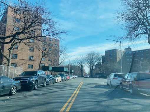
The street grid of Queens has its last number at 271st Street on the border with Nassau County. The start of this street grid is in Astoria, on a knob of land where the neighborhood’s founder, Stephen A. Halsey had his mansion. Seven decades after the Astoria Houses erased traces of Halsey’s waterfront village, these low-income projects are getting new neighbors in the form of high-rise towers served by a ferry to Manhattan.
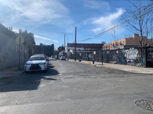
Besides the 29-acre superblock covered by Astoria Houses, the Hallets Point peninsula also has four blocks that escaped the urban renewal bulldozers, consisting of light industry and residences. There’s also a baseball field here named after Whitey Ford.
OPEN STREET MAP: HALLETT’S COVE
As this century progresses, the entire eastern shore of the East River, from Brooklyn Bridge to Triboro Bridge is being transformed by high-rises that are matching the Manhattan skyline on the opposite shore.
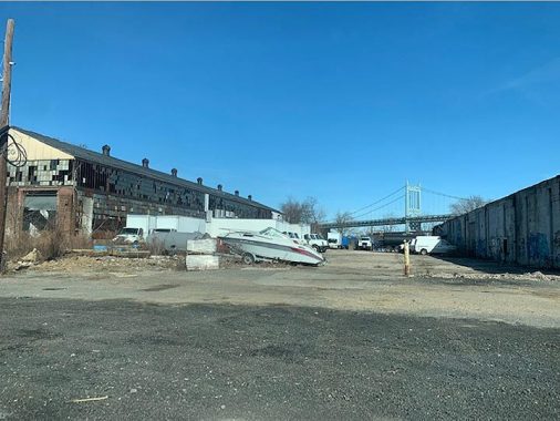
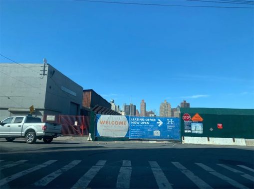
The bridge renamed in 2008 for the brother of President John. F. Kennedy is still called Triboro by most New Yorkers. At a dead-end on 26th Avenue, one can see this bridge on a lot awaiting redevelopment. The site faces Pot Cove, the smaller of the two coves framing Hallets Point. In 2014 this former manufacturing site was rezoned for high-rise residences, including provisions for a new public school, affordable units, and access to the water’s edge. Pot Cove is not a very marketable name so it appears on real estate documents as Astoria Cove, after the rapidly gentrifying neighborhood in this corner of Queens. The first shovels have yet to hit the ground here, but it’s only a matter of time.
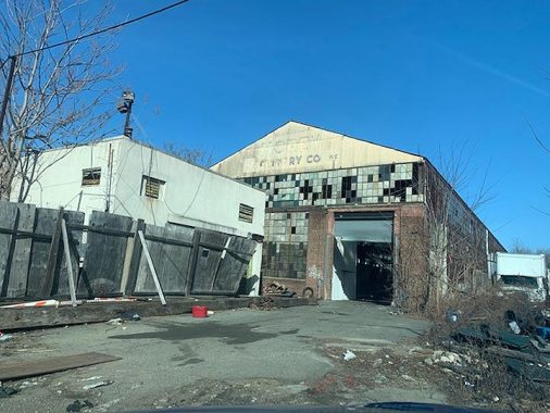
One of the industries that used to provide jobs at Pot Cove was Morey Machinery, which relocated to Florida. Its neighbors here included a lumber and coal yard, and stone works. The pre-industrial history of Pot Cove is discussed in detail in the archeological report commissioned by the city in 2013. Old maps of this site can be found in this report authored by Prof. Celia Bergoffen.
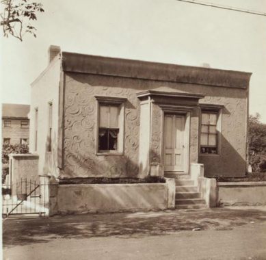
On the set of old streets at Hallets Point, Third Street has an old house that caught the attention of city photographer Percy Loomis Sperr in 1935. At the time, the cement exterior of this little dwelling had whimsical swirls on it.
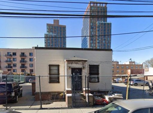
These days, the artistic patterns on 2618 Third Street are covered up by white vinyl and the entire property is paved in concrete, used for parking vehicles. The newcomer to the neighborhood rises in the background and certainly this old house will also be replaced by more towers.
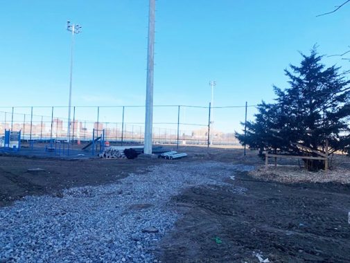
To the west of the Astoria Cove site is Whitey Ford Field, a 3.6-acre park located on the tip of Hallets Point. Having documented other spits of land across the city, I recognize that this one also has a military past that protected the city from a British invasion that never happened. In 1814, Gov. DeWitt Clinton laid the cornerstone of Fort Stevens at this site. Its namesake is Major General Ebenezer Stevens of the State Militia, who lived nearby. Ironically, Astoria, Oregon on this country’s west coast also has a Fort Stevens, named after a later general unrelated to Ebenezer Stevens. Both Astorias are named for John Jacob Astor.
As it faced dozens of rocks and reefs on the most dangerous stretch of the East River, this point had a series of lighthouses to warn ships of the navigational hazards. In 1885, this point was used as a staging area for explosives that blew up the reefs of Hell Gate.
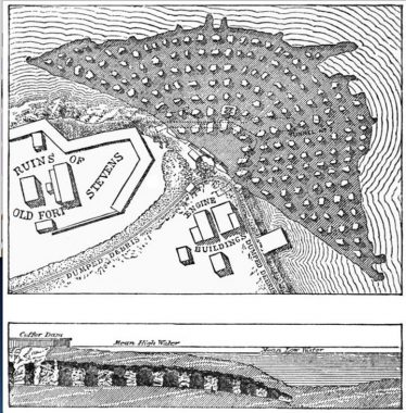
At Hallets Point, dozens of tunnels were dug under Hell Gate, then filled with 300,000 pounds of explosives. The massive explosion was felt for many miles. It produced a geyser that sent water 250 feet into the air. Some of the rubble from Flood Rock was used to connect Little Mill Rock to Great Mill Rock, producing a single island. I do not know how many of the estimated 200,000 spectators along the shores were blown back by this blast. The last light tower here was removed in 1982. The city acquired this land in 1906 for sports purposes. It was renamed for the Yankee Hall of Famer in 2000.
At the time of my visit, the field was under reconstruction, like much of the neighborhood. From the tip of Hallets Point in this park, one can see Gracie Mansion, Mill Rock Island, Wards Island, and Hell Gate with its two bridges.
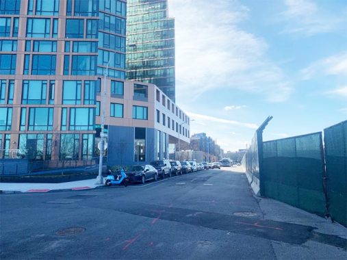
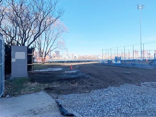
Looking south from Whitey Ford Field to First Street where the numbering grid begins, the first of the Hallets Point high-rises dwarfs the public houses behind it. For now it stands alone but will soon be joined by more towers overlooking the East River. When the street grid was designed in the 1910s, future land reclamation was factored into the plan.
At Hallets Point, the water is deep and the channel is narrow, making it unlikely that its avenues would be extended west of First Street. What numbers would be assigned to addresses on such a theoretical extension? That determination would be made by the topographical bureau at Borough Hall. Prior to the rezoning, some of the avenues protruded west of this street, dead-ended at the water, but they never had addresses on them. A couple of miles to the south, the route of First Street appears in Hunters Point, where it carries the name Center Boulevard.
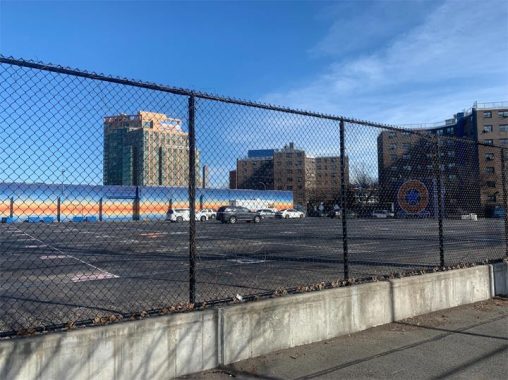
The western tip of this peninsula has Hallets Point Playground, which is mostly a paved sports field; and a private lot named Radial Park. This future development site became useful during the social distancing pandemic as an outdoor movie theater with the Manhattan skyline as the backdrop.
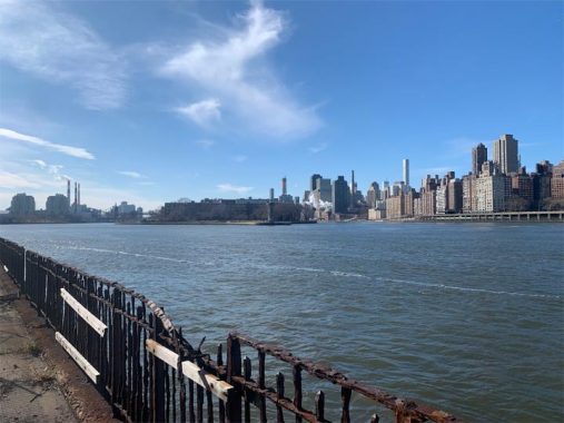
Looking south from Radial Park is Lighthouse Point on Roosevelt Island, a thin tip of land that Kevin visited in 2015. The railing on the seawall here is in need of replacement.
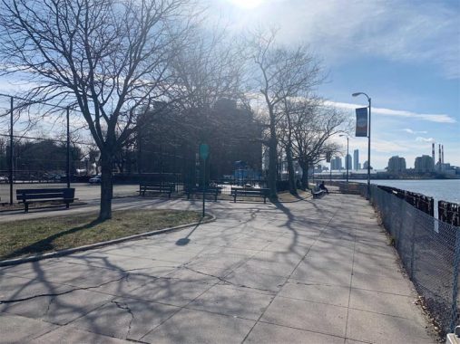
The esplanade on the seawall here is ideal for a stroll, if one doesn’t mind the strong wind that blows on any tip of land sticking into the water. Prior to the Triboro Bridge, this location had a ferry dock that took commuters across the river to 92nd Street on the Upper East Side. The last boat departed from Astoria on July 31, 1936, following a power struggle between master planner Robert Moses and Mayor Fiorello LaGuardia.
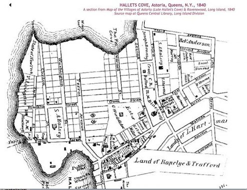
My photo essays often feature historical maps to tell the story. On this 1840 map, we see the ferry landing. At the time, Astoria Boulevard was called Fulton Street. Seems like a theme because the Fulton streets of Manhattan and Brooklyn also connected to ferry docks. Likely they all shared the same namesake, steamboat inventor Robert Fulton. At the tip of Hallets Point, Fort Stevens was gone but the land still belonged to the state. The largest landowner here was Stephen A. Halsey, who gave Astoria its name in 1839, after his friend John Jacob Astor, who owned land across the river. But Astor never set foot in his eponymous village.
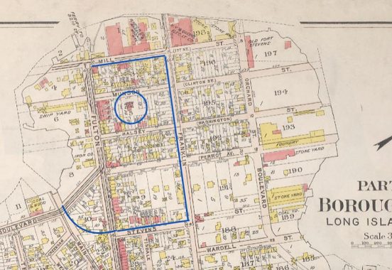
On the 1909 Bromley map of Astoria, I circled Halsey’s mansion and the borders of the NYCHA Housing project that later devoured it. At the time, the former residence was used for Long Island City High School. Stoneworks, shipyards, foundries, and other industries lined the water’s edge on this map.
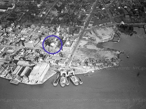
In this 1940 aerial survey from the Municipal Archives, the ferry dock is used for storage of boats and the Halsey Mansion is circled. Three years later, Mayor LaGuardia announced plans for a public housing complex at Hallets Point. At this point, the old mansion was used as the P.S. 9 elementary school.
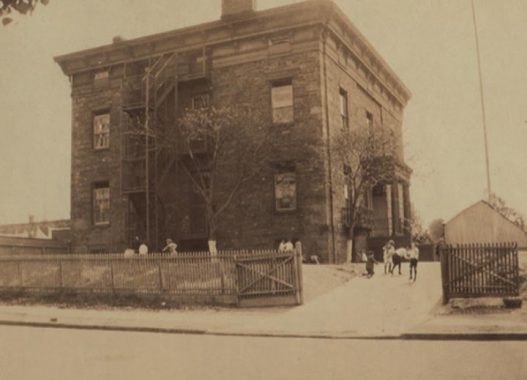
Astoria still has a few mansions from the 19th century that Kevin documented on his visits to the neighborhood, but the Halsey Mansion can be described as their parent, the trendsetter that encouraged wealthy Manhattanites to cross the river and build here. His goal of attracting investment from its namesake financier however did not succeed. In this 1923 photo from the NYPL collection, we see the students playing in the mansion’s yard.
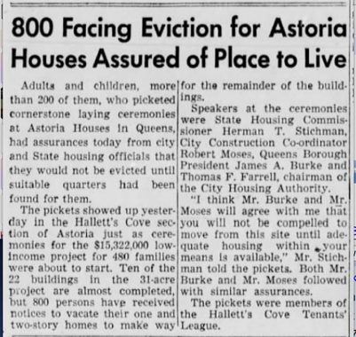
The city acquired title to 134 properties on 29 acres on Hallets Points in 1946 and the groundbreaking took place two years later. As with many Robert Moses projects, there was public opposition from residents who protested the “slum clearance” in a neighborhood of old mansions. Among them, Halsey’s former home was vacated by the school in 1950 and unceremoniously demolished. Don’t think that he’s forgotten. In Rego Park, Junior High School 157 is co-named for Halsey. What’s the connection? 102nd Street was called Astoria Road before the grid assigned it a number.
The construction of Astoria Houses resulted in the breaking up of Astoria Boulevard, with cul-de-sacs on each side of the housing campus. With the construction of new residential towers on the water’s edge, Astoria Boulevard will be reopened through this superblock. In a time when streets are being demapped, and space for cars is being reduced, this is a rare example of a historical road returning to the map, allowing travelers to travel from one end of Astoria Boulevard at Hallets Point, to its eastern tip on the edge of Flushing Meadows.

With a growing population and considerable distance from the Astoria subway line, the city reintroduced ferry service to the neighborhood in 2017, with a new dock at Hallets Cove Playground on Vernon Boulevard. The passenger boats connect to stops downstream at Roosevelt Island, Long Island City, 34th Street, Williamsburg, and Wall Street. In 2020, direct service between Astoria and 90th Street on the Upper East Side was introduced. For the first time in 84 years, one could take a ferry between these two points.
Sergey Kadinsky is the author of Hidden Waters of New York City: A History and Guide to 101 Forgotten Lakes, Ponds, Creeks, and Streams in the Five Boroughs (2016, Countryman Press) and the webmaster of Hidden Waters Blog.
Check out the ForgottenBook, take a look at the gift shop, and as always, “comment…as you see fit.”
1/31/21
7 comments
In the 70s, my friends and I got on the roof of that warehouse somehow. It’s a miracle we didn’t fall through. I recall it wasn’t terribly sturdy and it’s quite a drop to the ground.
That was when we weren’t climbing up the Hellgate Bridge. Back then the entance on Shore Blvd hadn’t been sealed up yet. Pity we didn’t have websites back then. We didn’t know we were “urban explorers” instead of just miscievous, little boys.
Came across an additional photo of the Halsey mansion in use as a school in the Municipal Archives. You’ll note some architectural details that did not survive to the 1923 photo. Perhaps the mansion had recently switched from use as the local high school to an elementary school as it is shown as “L.I.C. High School No. 9”? Halsey mansion circa 1908 in use as public school
Incredible article full of documentation and new information. What about the site of the Volunteer Coast Guard station which was near Morey Machine at the foot of the street? Do you have any information about that structure? Thank you.
So grest of a story very interesting and both sad at the same time
“What numbers would be assigned to addresses on such a theoretical extension?” Well, there’s always 1/2 Street. As there’s already A Street (Elmont), and Avenue A, they could do A Road, etc. Or use the Greek letters Alpha, Beta, and so on.
I’m in my early 80’s and I am trying to locate the site of what I think was called Queens Park, where barnstorming baseball teams played regularly. I was less than 10 years old, so the memory has had 70 years to germinate. For some unknown reason, I believe the park was somewhere between the Boulevard Gardens apartment complex and St. Michael’s Park and the Bulova factory. I
remember meeting Dan Bankhead (played for the Brooklyn Dodgers) at one of the games. He was only about 6-1 but to me he looked like a giant. After the game he gave me a scuffed up
baseball.
[…] a fast-moving current that terrified ships for the past 400 years. The removal of dozens of rocks near Hallets Point made navigating easier at Hell Gate, but still not smooth. Perhaps that’s why as other parks […]