

After finishing my walk on State Street, I continued into Brooklyn Bridge Park to take a look, but that’s perhaps a page for another day. To get there, I went north on Columbia Place, a one-block street connecting State and Joralemon just east of the Brooklyn-Queens Expressway, built here from 1945-1952.
There are no less than three streets named Columbia in western Brooklyn near the East River. There’s Columbia Street, which begins at Atlantic Avenue and runs southwest to Erie Basin in Red Hook; Columbia Place; and Columbia Heights, which is atop a cliff overlooking the East River. Originally there was a steep hill down to the next street west, Furman, but the BQE and the Promenade have been superimposed on the cliff. (This makes any rehab or repair job on the BQE very difficult, but that’s something traffic engineers will need to grapple with.)
Were the three Columbias ever connected? Not on maps going back to the 1850s. An 1858 map calls Columbia Heights “Street.” However, another section of that map does not connect them. It could be that all three were parts of Columbia Street, but it was never continuous (which happens often in other cities such as Philadelphia).
See Comments for a definitive answer.
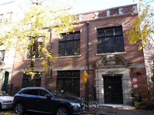
#27 Columbia Place, on the east side of the street, was built in a subdued Beaux Arts style in 1905 as the Willow Place Chapel House, a local community center; the chapel itself, now a playhouse, is behind the building on Willow Place. During the flu pandemic of 1918, it served as a call center for medical assistance in an era when many homes still didn’t have telephones; doctors and nurses were stationed here. The building has also been home to a number of music schools, a furniture maker, and a machine shop.

I’m a big fan of the Alfred Tredway White buildings in Brooklyn. White was a developer, but also a philanthropist: from 1876 to 1879 he constructed what were then affordable homes for working men and their families in what by today’s standards are magnificent brick buildings along Warren and Hicks and in the private way, Warren Place, between Warren and Baltic Streets. While the Place originally housed the lower to middle classes, the small attached houses there now routinely sell for more than $1M, even in the housing downturn that started in 2008 and was still in effect in 2011.
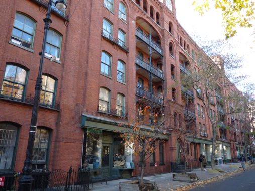
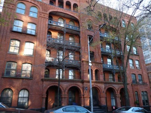
Another White complex, called Riverside, was built between Columbia Place and Furman Street south of Joralemon in 1890 and its mission was the same as at the Tower and Warren Place complexes south of here. It was originally 9 buildings and featured cross ventilation and bathrooms with running water, which were innovations for tenements at that time. Reformer Jacob Riis was a big fan. In 1890, apartments rented for $8-11.00 per month, which would be about $300 today. In the 1940s, Robert Moses tore down four buildings in the complex to bruit through the BQE.
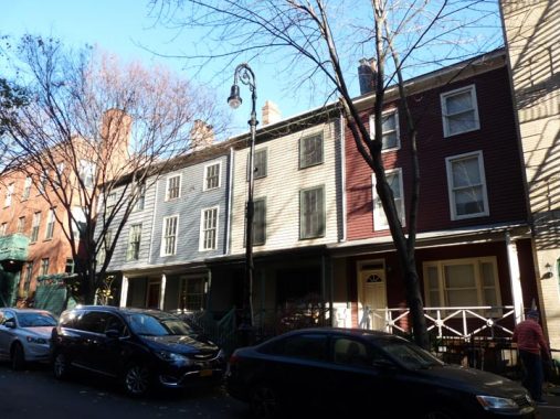
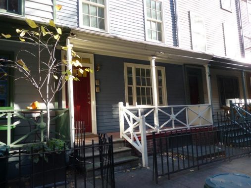
Houses with porches are a rarity in Brooklyn Heights, whose narrow plots are filled with woodframe and brownstone buildings, but in the late 1840s, nine small woodframe cottages with narrow porches were built on the east side of Columbia Place. Four such remain today, at #7, 9, 11 and 13.
Joralemon Street runs from Fulton and Adams Streets west to Furman, slightly athwart the street grid, as shown on this 1827 map, indicating it likely predated the other streets. It was named for Teunis Joralemon (1760-1840) a prominent landowner and jurist who descended from a 17th Century Dutch family. He purchased property from Philip Livingston, a signer of the Declaration of Independence. Out of towners are perplexed by the pronunciation, Jor-OLL-amun (when I was a kid and I saw it on maps I thought it was JOR-a-lemon, like the fruit).
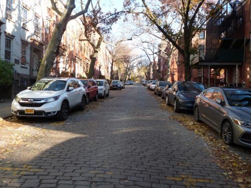
This stretch of Belgian blocks running from Hicks Street to Columbia Place is one of the handful remaining in Brooklyn. In the 1910s the IRT subway was tunneled under the street — one of three east-west Brooklyn Heights streets to carry a subway. When I was riding the buses as a kid with my parents, the B63 from Brooklyn turned right at Hicks, left on Joralemon, and left on Furman to its terminal on Atlantic.
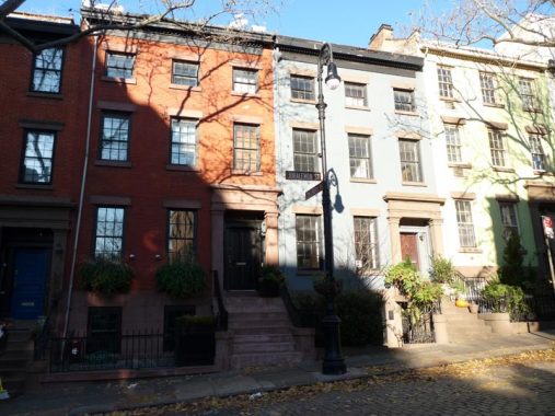
The cluster of houses at Joralemon and Columbia Place are brick row houses built around 1845.
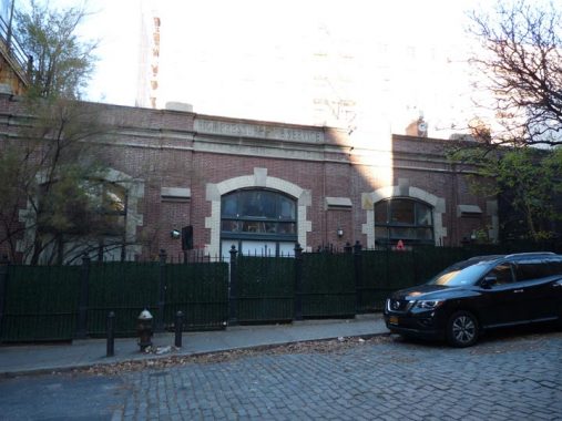

This is a former high pressure pumping station built for the FDNY in 1908. Though about a quarter of it was lost to BQE construction in the 1940s and 50s, it was in service until 1954. It’s now a coop called Heights Mews.
Between Atlantic Avenue and Old Fulton Street, Joralemon is the only major street that gets past the BQE to end at Furman. However this 1929 map shows that most of its partner streets in Brooklyn Heights went down the steep hill to the waterfront.

Two of the BQE’s triple decks are shown here. At Remsen Street, two blocks north, a third deck supporting the Promenade is added. Engineers are debating how to fix the BQE; one solution calls for running a temporary expressway atop the Promenade. Needless to say, that idea is strongly opposed by Brooklyn Heightsers.

Here’s a vintage finned “Whitestone” lamp mast; they were first used on the Whitestone Bridge in the 1930s. Very few of these remain whether they are attached to poles or affixed to walls.
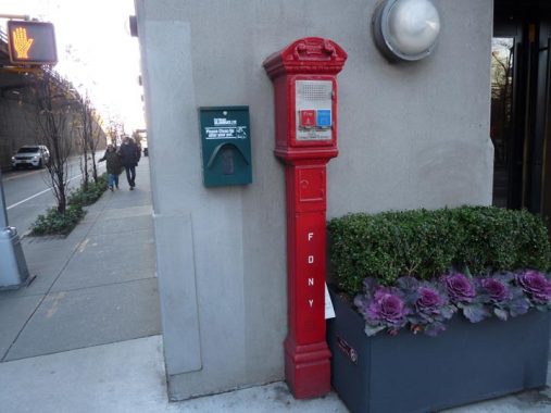
Some more relics for you. This fire alarm at Joralemon and Furman may be the only working model of its type left. Here it’s attached to a wall but in general hey were usually found clinging to cast iron lampposts.

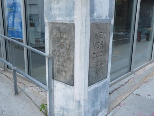
When Brooklyn Bridge Park was developed beginning in 2012, most of the old docks administration buildings and remaining warehouses along Fulton Street were razed, with the exception of this New York Dock Company administration building, first erected in 1917. Two very large NYDC warehouses can still be found on Imlay Street in Red Hook.
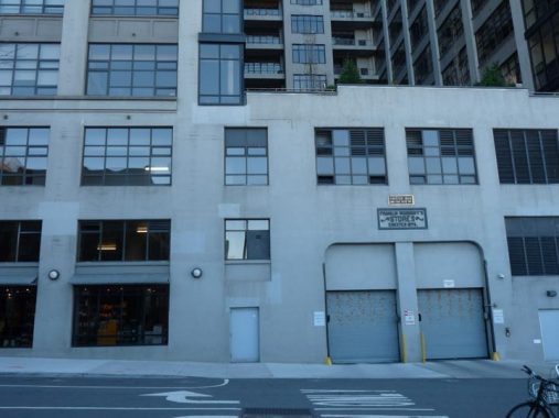
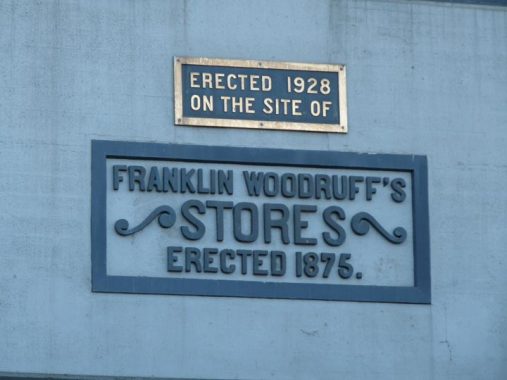
One Brooklyn Bridge Park, a luxury building bordering the park, doesn’t look like much on its Joralemon Street side, but if you’re in the right locations, it has tremendous views of the harbor and Manhattan. Built as a warehouse in 1928, it was converted to luxury residential in 2008. I had never noticed these historic signs on Joralemon Street.
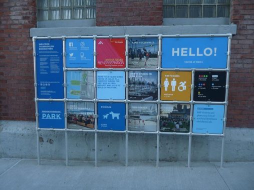
Brooklyn Bridge Park has its own peculiar signage and lighting, which I’ll get into someday, but these signs resemble gates that have had signage added to them.
Info from Willowtown Walking Tour and Brownstoner.
Check out the ForgottenBook, take a look at the gift shop, and as always, “comment…as you see fit.”
3/9/21
4 comments
In the 1960s it was a tradition to trick or treat at the Towers on Halloween because it was so spooky.A puerto rican man would
always dress up as a monster and chase the kids around the place.All in good fun.Today he would have faced a lawsuit for
inflicting trauma on them..
All three were originally Columbia Street, but as near as I’ve been able to find, were never connected. Areas like the Heights, Downtown, DUMBO and Vinegar Hill predate the first citywide grid plan (1830s), and were more haphazard in development. The two “disjointed” sections of Columbia Street, to the north of Atlantic Avenue, were renamed as Columbia Place and Columbia Heights by the Brooklyn City Common Council on November 29, 1869, effective December 13, 1869.
Great bits of history and things of interest…. I wish a sentence had been introduced about “Adam Yauch Park.” Of more minor importance is the fact that the NY Dock Co. building has been “repurposed” as the administrative center governing Brooklyn Bridge Park. There’s also another building a bit north on Furman. Maybe, the next installment will reveal whether that’s subway-related … or what.
See my State Street post for that.