

Rose Street isn’t much of a street and most New Yorkers don’t know it exists. Currently, it serves as a connector between Gold and Frankfort Streets and Pearl and Madison; the latter than travels up the Lower East Side to Corlears Hook.
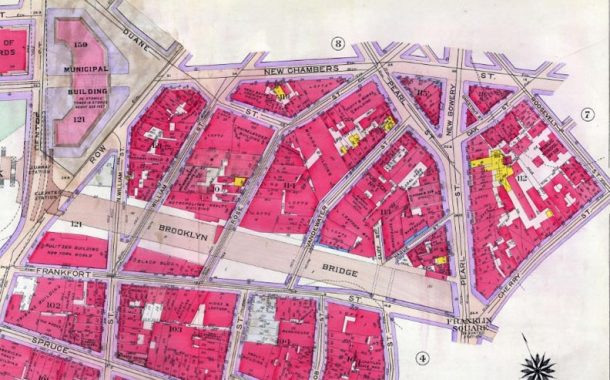
On this 1915 map you can see that Rose was one of a number of short streets under the Brooklyn Bridge that also included streets such as the north end of William, Vandewater, Cliff, Hague, New Chambers, Chestnut, Batavia and Roosevelt.
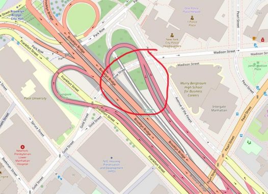
in the mid-20th Century most of these streets were eliminated and replaced by ramps connecting the Brooklyn Bridge to the FDR Drive, as well as Murray Bergtraum High School, Southbridge Towers and the new NYPD headquarters, which arrived in 1972. Rose Street, which once ran from Frankfort to Pearl, was cut down to just a short section that allows traffic under the Brooklyn Bridge. Without it, traffic would have to use Pearl. There are no addresses on Rose, and only one street sign, last I looked.
What did Rose Street look like? The Municipal Archives has the answer. You can also look for the other short streets mentioned here.
As always, “comment…as you see fit.” I earn a small payment when you click on any ad on the site.
6/10/21
3 comments
Is there really a Peeral Street or did you just happen to misspell Pearl at the top of the page?
You got me.
You should do a story on what lies beyond the fences on both sides of Rose Street. It is called the Brooklyn Banks and it is a historic skateboarding spot that has become a abandoned and decrepit. It’s a forgotten piece of downtown Manhattan.