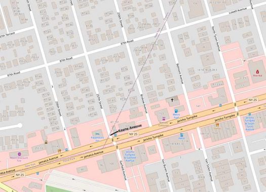
I have found what is, without a doubt, the shortest street in the NYC metropolitan area and possibly, the shortest in the United States. It’s found at the undefended border of Queens and Nassau Counties, where the territories on both sides of this danger-fraught line are called Floral Park. It’s a street that shouldn’t happen, under modern methods of boundary line engineering.
Let’s move further west for the moment, at another undefended (but it really should be) border, between Kings and Queens counties. At the eastern end of the town of Bushwick the line between Kings and Queens was rendered as a straight line in the late 1600s. But as the centuries rolled on and towns, streets and houses appeared, the line crossing through homes proved awkward for tax collectors and post offices, and the line was changed in 1925, zigzagging up and down streets, presumably in the center median.

However, at the Queens-Nassau line, no such niceties were followed when eastern Queens divorced itself from western Queens over inclusion in Greater New York and courthouse placement, and here the line is still perfectly straight. Note where the line reaches Jericho Turnpike at 257th Street. It doesn’t quite make it to Jericho Turnpike, leaving a tiny piece of 257th Street completely in Nassau! Depending on where you draw the line, it possibly leaves a tiny triangle shaped plot in Nassau County. What do the signmakers do?

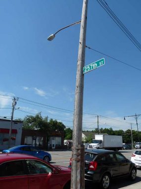
On the Queens side of the street, you have a finned lamp mast used exclusively in New York City, but a Nassau County-style 257th Street sign…

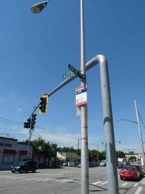
…and on the Nassau County side, a Nassau-style davit stoplight and a … Keene avenue sign! That’s right, the tiny piece of 257th Street contained within Nassau County has its own name.
It’s not that Nassau disdains Queens numbered streets completely. There are streets with Queens numbering in such far flung locales as Great Neck and Elmont. But not here, not in Floral Park, and city fathers have given a triangle a street name rather than let a Queens numbered street besmirch the town.
That’s what I call shade! Which there wasn’t much of the day I shot this in the July 2020 dead dog heat.
As always, “comment…as you see fit.” I earn a small payment when you click on any ad on the site.
3/5/22


6 comments
If you scroll north from Jericho using Google Street View the address box in the upper left corner of the screen shows it as 257th starting right at the intersection. The Keene Avenue name never makes an appearance in that box, although the name appears on the road right in the middle of the intersection. Confusing? Definitely.
Of course this is an interesting area in another respect, being close to the remnants of the LIRR Creedmoor Branch. Just a few steps away from Keene/257th on the south side of Jericho is that long narrow municipal parking lot that follows the old right of way. I explored it on foot a few months ago and to my surprise actually found a few very short rail segments. They’re next to a concrete structure that Iwas a coal silo long ago.
The LIRR’s Creedmoor Branch r.o.w. is a small part of a much longer 19th century railroad that operated between Long Island City and Babylon, and was profiled in FNY in August 2020. The old railroad is the Central RR of Long Island, founded by department store magnate Alexander T. Stewart as a competitor to the LIRR, and a means to provide transportation to a new planned community that became the Village of Garden City. While the Central RR of LI is out of business for nearly 150 years, the LIRR took over significant parts of it. One became today’s LIRR Hempstead Branch between Floral Park and Hempstead; the other is today’s Central Branch which connects Bethpage and Babylon without any stops in between. Alexander T. Stewart, is also remembered because Garden City memorializes him with one of its principal thoroughfares, Stewart Avenue.
As of the November 2021 Google Street View, Keene Avenue is now Keene Street unless the sign making authority made a mistake when installing a replacement.
The most populous county in Arizona is Maricopa; the last town in SE Maricopa county is Queen Creek. The next county is Pinal. In the early twenty-first century, developers began construction of residential communities in Pinal Co. It happened so quickly that for lack of any other name it was called Queen Creek. Eventually, as the population grew rapidly this unincorporated community on the Pinal Co. side held a referendum & this area chose San Tan Valley & gained its exclusive zip code. This was a more sensible solution than Floral Park with its two area codes, etc. which must create difficulties for 911 dispatchers. The Floral Park situation is sort of like East Berlin/West Berlin without Stasi & a wall.
They recently put up a new street sign there but mistakenly it says Keene Street.
I found a map of this area from 1914 that shows Keene Ave. as a few blocks on what is now 257th Ave. Current Google street view shows the street sign as Keene St. An error at the sign shop no doubt. There is also one property listed for Keene Ave. The current street map shows Keene Ave as a shaded path along the parking lot with an arrow pointing left to it, just north of the corner another shaded path to the right through an empty lot. Truly a mystery spot at the Queens /Nassau border.