

In no other Manhattan neighborhood has the street map changed more greatly over the decades than the Lower East Side, more specifically the easternmost section known as Corlears Hook, where both the island’s coastline and the East River make a sharp turn to the north. In recent years, NYC Parks has closed its major oasis of green, East River Park, killing it so they can save it, so to speak, as a new storm surge barrier is built to hedge against flooding caused by global warming (it’s 90 degrees as I type this on May 21st; incidental, I know).
I digress. Corlears Hook formerly had a very tight grid of streets jammed with overcrowded tenements and industrial works on its eastern end. As this article in The Lower East Side History Project explains, in addition to being crowded it was also dangerous as street gangs divided it into territories …
Continuing down the renamed Jackson Street, you spot one of the numerous, decrepit, docks lining the foggy East River. Chatter and wicked laughter can be heard throughout the thick sea air, as you peek under Pier 57. Encamped around a small fire divvying up loot is the murderous Short Tails Gang.
Headquartered on the corner of Rivington Street and Goerck Street (today’s Baruch Playground), the Short Tails terrorized the Corlears Hook docks by robbing, beating or murdering incoming boats and sailors. Not wanting to get involved with such a brutal crew, you walk along Cherry Street only to encounter the Daybreak Boys, the greatest of the East River pirate gangs. Known for sabotaging boats in early morning hours, they are rumored to be responsible for up to 40 murders in a two year period. Further down the waterfront, Patsy Conroy has recruited some of the most infamous thieves to inherit the mantle as the most dangerous gang in Corlears hook. Luckily, the failed Mattan Robbery would be the undoing of this gang.
In the name of “slum clearance” hundreds of the tenements and industrial works were removed and the familiar “towers in a park” concept was hatched, with the largest such in the area being the Seward Park Houses and Baruch Houses. A number of streets were wiped off the map. Recently, I took a walk around the area and surprisingly a number of these streets have had small pieces preserved or have left their mark in other ways; but that’s another page, another day.
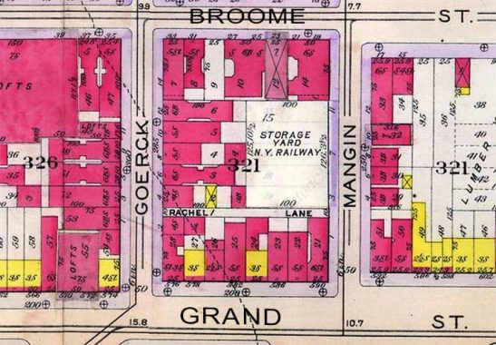
Today, I want to hone in on a tiny alley that has vanished, named Rachel Lane (the street name sounds like it would belong to a woman who writes children’s books). It can be seen on this map produced in 1909; today, this entire acreage is covered by the Corlears Hook Houses and only Grand Street is still in existence.

As this excerpt from the City Record in November 1903 (is it still published?) demonstrates, Rachel Lane was laid out in the spot shown on the 1909 map that year, and built shortly thereafter. It survived until the Houses went up in the 1950s. The question is, why was such a short street commissioned, and who was the Rachel it was named for? Unanswerable questions, at this remove.
(Note: Commenters have found references to Rachel’s Lane as early as 1853! See below)
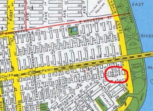
This 1949 Hagstrom map shows Rachel Lane (circled) but does not name it; space limitations sometimes prohibited the mapmaker from showing everything. You can see the original street layout is under transition as already the Vladeck Houses have taken out some streets south of Grand.
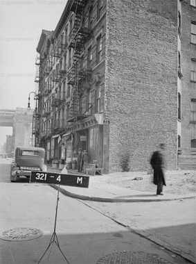
I’ve never found a photo of Rachel Lane but this 1940 view of #8 Goerck (later renamed Baruch Place; a short piece remains) comes tantalizingly close, as you can see its curb cut and a very short piece of it. In the background you can see the Williamsburg Bridge approach over Delancey Street.
As always, “comment…as you see fit.” I earn a small payment when you click on any ad on the site.
5/21/22
11 comments
The very final scene of the classic film noir The Naked City, shot on location in 1947 and released the following year, has the NYPD closing in on a killer as he attempts to escape by climbing the Williamsburg Bridge’s Manhattan tower. During the scene, the cameras pans the Manhattan shoreline and shows people playing tennis, on the courts directly below the bridge and the BMT tracks. The Hagstrom Map clearly shows the tennis courts. This film has the best NYC background scenes I’ve ever seen.
I thought Rachel Lane was a song that didn’t make it onto Abbey Road; the original tapes forgotten about till they were discovered in a biscuit tin in George Martin’s attic 40 years later.
I wonder what the railroad storage yard was.
New York Railways operated the vast majority of Manhattan’s streetcar (trolley) routes at the time this map was printed. So that location was a storage yard for streetcars – the equivalent to a bus garage or depot today. The location was not a storage facility for subway or elevated train cars.
This sparked my curiosity so I commenced to searching – no clue as to who was Rachel. It shows on Rumsey’s 1852 map unnamed.
It was named Rachel’s Lane much earlier than 1903. 1875 City Record shows a paving request for Rachel’s Lane at Goerck. 1886 (June 9) Board of Alderman records show a resolution to install gas lamps at either end. The 1903 city record opening, then Feb 9 1907 a legal notice in the NY Times announced its opening again.
The New York Tribune says it was called Pig Alley; that a pig farmer lived there and that the city tried to remove him and his pigs multiple times until he died triumphant. In 1916 in spite of all the openings people were still calling it Pig Alley.
The city finally put up signs indicating it as Rachel’s Lane to much derision from the locals. Kids in the neighborhood threw rocks at the signs. The Summary in 1916 published a short piece where the pharmacy owner on the corner of Rachel’s Lane had no idea where Rachel’s Lane was. The NY Tribune ran a short article in 1916 with the lede “White and Blue sign Gives New Name to Impassable Street.” The Sun that year disapproved of the name change stating “History is written in names, and those who edit .. are vandals.”
10 feet from property to line to property line one of the city’s narrowest it apparently was not paved or cleaned. In a 1922 letter to the editor of the Daily News George I Corker of 4 Goerck complained that the debris is over a foot high and when he complained to the street cleaner the cleaner told him to go to hell.
The New York City Department of Citywide Administrative Services still publishes the Daily Record, and it’s available online. https://www1.nyc.gov/site/dcas/about/city-record.page
Interestingly, the March 13, 1902 edition of the City Record discusses a resolution by Adlerman Devlin to have “the pavement of the carriageway of the thoroughfare known as Rachel’s Lane, between Goerck and Mangin Streets…to be repaired.” The same edition has another resolution by Devlin to put up a street lamp at each end of Rachel’s Lane. An 1852 map available online appears to clearly show Rachel’s Lane, unmarked: https://digitalcollections.nypl.org/items/510d47e0-c7d6-a3d9-e040-e00a18064a99 , which tells me the lane is of at least antebellum vintage. The 1884 minutes of the Board of Estimate are available online, and discuss the street-cleaning schedule for “Rachel’s Lane,” which at a superficial bit of research is the oldest reference I can find to that name [Rachel’s] being used.
You can also just see the east end of Rachel Lane here: https://1940s.nyc/map/photo/nynyma_rec0040_1_00321_0021#17.84/40.714064/-73.977237 Block 321, lot 21 is the lot at the corner of Mangin and Grand. I cross-checked the 1939 telephone directory, and the East River Drive Auto Repair Shop depicted in the shot is indeed at 590 Grand, the corner of Mangin and Grand (GRamercy 5-8618). Which to my mind confirms that you can see the outlet of Rachel Lane at its back, where the third car from the left is parked.
” Encamped around a small fire divvying up loot is the murderous Short Tails Gang.”
I could be wrong But according to Luc Sante and others, the correct name was/is the Shirt Tails.
I take it that this street is either renamed or demapped if I was to look at a map of the area today.
…today, this entire acreage is covered by the Corlears Hook Houses and only Grand Street is still in existence. (From the article)