

So this week I celebrate my 65th birthday, while having no intention to retire unless my current employer or other potential employers decide they don’t want me working anymore. I have a white beard; it was all brown when I began Forgotten NY. This website is approximately 23 and a half years old, so we’re well on the way to a quarter century of Forgotten NY, which I began just past 40 years old. Imagine had I begun photography for the site in the 1970s how great it’d be now. Had anyone asked me in 1998 whether Forgotten NY would still be a thing after 23 years, I would’ve said,
Hell yeah, why not?
I have lived in NYC for all of those 65 years, though I have moved ever closer to the undefended border of Queens and Nassau County, in my current space for over 15 years. Moving is such a pain in the neck, I hate having to do so: thus, I purchased a co-op which is about 60% paid for, so I wouldn’t have to move unless I wanted to sell. Despite being a lifelong resident, I do not take advantage of the innumerable culinary goods available in such an immigrant city; I like what I like, pretty much, and stay with what I like. Since I have always disliked show music, I have never witnessed a Broadway musical in person, despite the hundreds available in the Times Square area to see. There’s a lot of jumping around, singing, dancing and smiling, none of which I do very much; I recognize the talent involved but have no desire to see it, the same as rodeo, motocross racing and soccer, none of which I have ever seen in person either. So what do I do? Why am I here?
On my infrequent vacations, I do what I do when I’m not on vacation: stalk the streets with a camera, seeking out nonstandard infrastructure or other bits of business that don’t make the NYC guidebooks. If Forgotten NY has a legacy, I hope I have enabled people who both live here and who are visiting, to see New York in a different way. Which brings me to…
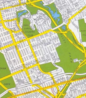
…Cloverdale Boulevard, which runs from 46th Avenue and 223rd Street in Bayside south to Union Turnpike at the Grand Central Parkway…or at least that’s what this 1949 Hagstrom would have you believe. Hagstrom, and other mapmakers, have always preferred to not represent absolute reality on maps, but what city planners and real estate developers have in mind. Thus, Cloverdale Boulevard hasn’t evolved exactly as those long-ago draftsmen anticipated that it would.
In the early 1920s, in addition to assigning the majority of streets numbers and creating a unique hyphenated house numbering method, the Queens Topographical Bureau also designated several major routes as “Boulevards.” Thus Vernon Avenue became Vernon Boulevard, Farmers Avenue became Farmers Boulevard, and so on. Jackson Avenue and Broadway were combined to create Northern Boulevard, which as also taken over Route 25A, North Hempstead Turnpike, in Nassau County (despite it running through the entire Town of North Hempstead).
Cloverdale Boulevard is one of the least important of Queens’ boulevards, though it has its traffic-busy moments. There are only a few Queens boulevards that are shorter or less important, such as Little Neck Boulevard (not to be confused with Little Neck Parkway) which is actually a pair of unconnected dead ends on 28th Avenue and 28th Road near Fort Totten, and Amstel Boulevard, which runs for a few blocks in Arverne on the Rockaway Peninsula.
Why “Cloverdale”? I can’t say exactly but I can guess. The boulevard runs south of the western edge of a large grassy area (before it was built up) in Nassau County called the Hempstead Plains. What do you find in grassy areas? Clover.
Because I never had, I walked part of Cloverdale Boulevard’s length recently and found some…stuff. I Street Viewed the rest, but hope to hike the remainder sometime soon.


Probably the most interesting thing to see on Cloverdale Boulevard is at the very beginning just south of 46th Avenue, where Oakland Lake comes into view. The lake is the largest of a number of small “kettle ponds” left over from the passage of a glacier that stopped its southern progress in the middle of Long Island 15,000 years ago. According to the NYC Parks Department, it was once thought to be 600 feet deep, but the lake bottom was found to be just 20 feet in 1969. Similar to what was done with Kissena Lake, Oakland Lake was surrounded with a concrete lining and “citified” in the 1930s. After lean years in which the lake’s condition deteriorated, a revitalization effort was spearheaded by local resident Gertrude Waldeyer, whose Oakland Lake and Ravine Conservation Committee raised $1 million to restore the lake to its natural state. It’s now home to catfish, sunfish and carp. Oakland Lake has taken its place, along with other Alley Pond lakes such as Turtle Pond, Potamogeton Pond, Lily Pad Pond and Muskrat Pond as small glimpses of real wetland in the city. A mansion built by a member of the prominent Lawrence family (whose private cemetery can still be found at 42nd Ave. and 216th St.) in the 1840s was called “The Oaks.” Signboards posted on Cloverdale Boulevard tell the lake’s story. Unfortunately it seems algae-ridden in mid-2022.
The neighborhood south of the pond, from 46th to 73rd Aves. and from 210th to 233rd Streets, Oakland Gardens, was named for the lake, or perhaps The Oaks. What is today Queensboro Community College and the neighboring Benjamin Cardozo High School are built atop what used to be the Oakland Country Club. See an aerial view here.
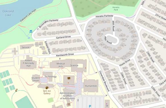
If you look at a modern map, a small suburban neighborhood has been carved out of the former Oakland Country Club. Unusually for Queens, we have a circular area similar to “Knots Landing” houses, though not a cul de sac per se. The area’s original British sounding names have been kept: Birmington (not Birmingham); Garland, Enfield; Kenilworth. The 1949 map above shows Chatsworth Place, absorbed by QCC.


The semicircle is defined by Horatio Parkway and Hoxie Drive, which don’t sound especially British to me, except that Hoxie is true-blue British and the family has a coat of arms. The name is a respelling or contraction of the more British-sounding name Hawkshaw.
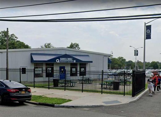
Queensboro Community, as seen from Cloverdale Boulevard, isn’t especially interesting to look at (unlike, say, the Queens College campus further west) but there is the world’s smallest Barnes & Noble. The branch has closed many of its supermarket-type bookstores but this one likely specializes in college textbooks (as did the original flagship on 5th and 18th near Madison Square).
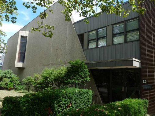
This building at #50-35 Cloverdale opposite the campus is the former Jewish Center of Oak Hills. I can’t account for that unyielding concrete wall facing the boulevard with a single bay window, but it might have had a religious reason. Enlighten me — Comments are open.
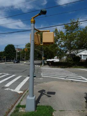
The local birds have made a nesting area out of this little doodad mounted atop a pedestrian signal at Cloverdale and 56th Avenue. These items used to be ubiquitous all over town and from what I hear, they were some kind of traffic volume counter. They would be mounted on these Type S-1A poles, and sometimes even on thick-bodied M-2A traffic light poles.


Another fascinating piece of infrastructure (fascinating to me that is) is this Deskey lamppost at Cloverdale and 57th Road. As versatile as the Deskeys were, the Department of Transportation never got a handle on how to place fire alarm lamps on them. An incandescent bulb would be mounted at the top of the shaft, and a regulation, cylindrical reflector cover as well. These were notoriously hard to keep from falling off and often the city would tape them in place. The Deskeys also had their own proprietary squarish reflector cover. Ideally the fire alarm lamps would be mounted mid-shaft, but the J-shaped pipes used to carry them couldn’t be mounted on the Deskeys’ grooved shafts.
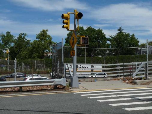
I mentioned that Cloverdale Boulevard was mapped as a continuous road in 1949. Today it exists in four separate pieces; here, it’s divided by the Long Island Expressway or as it’s known in Queens, the Horace Harding Expressway, named for a Robert Moses associate. (I would always get him mixed up with other Double H guys, like Herbert Hoover or Hubert Humphrey.) Since there’s already a “don’t walk” signal and a stoplight for autos, I don’t know what is controlled by that single light. Help me out–Comments are open.
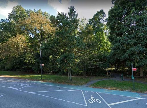
Cloverdale Boulevard continues south to 73rd Avenue (which many years ago was called Blackstump Road) but is stopped cold by a finger of Alley Pond Park that protrudes west from the main park area as far west as Springfield Boulevard.
The site is named for The Alley, an 18th-century commercial and manufacturing center formerly located here. The origin of that center’s name is the subject of some debate. One theory is that “alley” refers to the shape of the glacier-made valley. Another holds that colonial travelers, who passed through the valley to Brooklyn, en route to the Manhattan ferries, named it “the alley.” The well-traveled passage is believed to have been the route George Washington (1732-1799) took while touring Long Island in 1790. [NYC Parks]
If you look closely you see a marked trail just above the bicycle stencil. This meanders through this finger of Alley Pond Park and connects with…
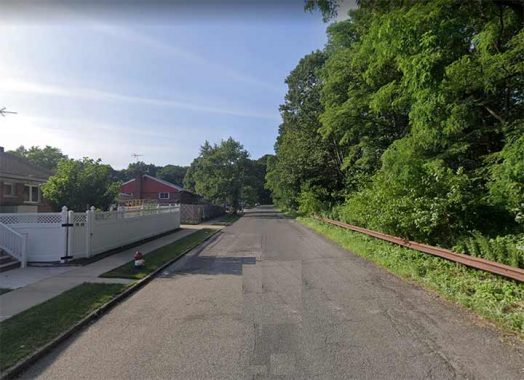
…the third section of Cloverdale Boulevard and by far the thinnest, seen here near 77th Avenue. Once entering Alley Pond Park again at 77th, you can access the Long Island Motor Parkway, constructed as an auto route by William Kissam Vanderbilt in 1908 and converted to pedestrian-bike traffic thirty years later: but the Queens section of the road opened in the mid-1920s. It once carried auto traffic as far east as Lake Ronkonkoma. A lengthy stretch of varying widths between Dix Hills and Ronkonkoma, known variously as Vanderbilt Parkway, Vanderbilt Motor Parkway and just plain Motor Parkway, still carries motorized traffic.
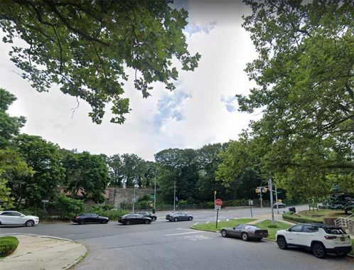
Finally, a short, one-block section of Cloverdale Boulevard runs from Kingsbury Avenue (south of the Motor Parkway) as far as a Grand Central Parkway service road, just short of Union Turnpike.
As always, “comment…as you see fit.” I earn a small payment when you click on any ad on the site.
8/21/22
20 comments
Just a guess that the red lights at Cloverdale and Horace Harding are to warn drivers that the road ends.
Even if a Broadway show doesn’t appeal to you, the interiors of some of the theaters are quite amazing and historic. I once had a chance to visit the old Belasco apartments which was like stepping back in time and a haunted house. You might be missing a lot.
Have a wonderful 65th Birthday and I hope to be reading Forgotten NY for another 23 years!
Thank you for that last photo. From 1991-2000 I lived on that very corner in the second-story apartment; the address is 226-73 Union Turnpike & it’s part of the Alley Pond Co-op (we were owners/shareholders). That last stretch of Cloverdale Blvd created confusion when reporting traffic accidents; the westbound exit ramp from the Grand Central Parkway (which the sign informs you is Union Turnpike) feeds into Cloverdale Blvd. I thought that it would be easier to report the location as Grand Central Parkway & Union Turnpike but the 911 operator rudely insisted there was no such intersection. My calculation was that this little-known final stretch of Cloverdale Blvd would get that response. It was a case of the road to hell being paved with my good intentions. Except for that one instance, it was a pleasure living there.
I’m going to make an educated guess that the Venn Diagram overlap between people interested in Broadway musicals, rodeo, motocross racing and soccer is very, very small.
It was Jewish Center of Bayside Oaks for most of its life before it merged with Bayside Hills… which was on 48th to become Oak Hills. There was a gas explosion there in the 70s. As for the window…the sanctuary is up there…it was for light as the only other windows for the sanctuary were in the left side wall. The other side of the second floor were classrooms for the Hebrew School.
Single light at Horace Harding is a flashing red or flashing yellow till you push the crosswalk button then it turns red to allow crossing.
https://www.nytimes.com/1956/04/08/archives/jewish-center-slated-ground-to-be-broken-today-in-bayside-oaks.html
Being half Jewish I can half guess that post WW2 Jews wanted nothing to do with the past and embraced modern with both arms. Even as a kid I felt 70s and on modern be especially hostile to its occupants.
Concentric roadmapping identical to National Drive just north of Kings Plaza, in Brooklyn!
Horace Harding Expressway. It wasn’t until the Internet was created that I learned who HH was. Not that I didn’t try earlier. Long ago in 1974, a friend from Ohio moved to Queens and we explored the neighborhood. We came across a branch of the Queensborough Public Library on the HHE and went in. He asked if they had a copy of his favorite childhood book FREDDIE THE PIG. I asked the librarian if she could tell me who HH was, after all, it was the name of the street the building was on and I felt she of all people would know. Both my friend and I were told no.
Since you brought up the Barnes & Noble on the QCC campus and near Madison Square, I now recall I visited the Madison Square location looking for a textbook that I could not find in the City College of New York (CCNY) book store. I do not recall if I was successful. I attended CCNY class of ’73.
That building on Cloverdale always stood out
Some more about Horace Harding and his namesake road, from the Wikipedia article available here: https://en.wikipedia.org/wiki/J._Horace_Harding
James Horace Harding (July 13, 1863 – January 4, 1929) was a banker, financier and art collector. He was a proponent of Robert Moses’ parkway plans, and personally commissioned engineering studies to promote the construction of a highway from Queens Boulevard to Nassau County, in order to provide better access to Oakland Country Club, where he was a member and avid golfer. The road was built during Mayor Jimmy Walker’s administration and was opened in 1928 as Nassau Boulevard. In May 1929, four months after Harding’s death, the road was named Horace Harding Boulevard in his honor. Originally it was a very wide (Queens Boulevard style) surface arterial road; in the late 1950s its right of way was rebuilt to accommodate the Long Island Expressway below grade (Route 495), and the name Horace Harding was assigned to the service roads that flank the expressway in Queens.
Happy birthday, Kevin. Best wishes for good health and peace. Forgotten Fan since 1999.
Well,you like letter design,dont you?You know the different styles of letters like
the electric “Z” in the Zenith TV set logo?Or how about that cool “M” in the Miller
High Life label?The old Dannon Yogurt typography?The New Yorker magazine has their
own private brand which you see copied all over the place.Theres even one named
for Charles Manson.
Happy birthday!
Hope your birthday was wonderful, Kevin! As for the name “Cloverdale”, that was also a telephone extension in the Midwood section of Brooklyn before telephone numbers became all numerals. I doubt that there is any relation between the Brooklyn Cloverdale and the Queens Cloverdale…
Happy Birthday Kevin!
Wish you good health and happiness always; and as one who was lucky enough to find you at the beginning of this journey, I sincerely thank you!
That device mounted on the S1A pole was part of the Dept. of Traffic’s ultrasonic detection system. Starting in the early 1960’s, the City began installing traffic actuated signals at certain intersections. Originally the detectors used were a type of radar sensor. The problem with using radar sensors was that it was a Federal requirement that anyone installing or servicing the equipment hold an FCC license. The City began using the ultrasonic detectors in 1965. The detectors emitted a very high pitched chirping that bounced back to the detector when a vehicle entered the sensing area. These systems were used at stand alone intersections. These intersections were set up so that unless a vehicle was detected, or a pedestrian push button was pressed, the light did not turn green for the smaller street.
Starting in the early 1970’s plans were carried out to link major streets to a main computer . Streets like 21st Street in Astoria and Long Island City received ultrasonic detectors on every side street. New York Telephone Company installed cables linking all of the control boxes at each intersection. I recall it was quite a while ‘till all the intersections were equipped. I don’t remember exactly when the system was activated, but I do remember that annoying chirping from the unit right across the street from my window.
The system must have been a complete bust. The sensors were shut off after only a few months, and a few years later Welsbach came and removed most of the S1A poles and sensors. Boxes flush with the sidewalk were installed which were used many years later with the buried induction loop traffic sensors.
There is a reason birds are nesting in this sensor ,and in most of the other sensors that are still around. People found out that the ultrasonic sensors were actually very high end tweeters. They were mostly all stolen and door was left open.