
I have always been fascinated with the High Line (or High Line Park), the linear park opened in stages beginning in 2009 on what was built in 1934 as the West Side Freight Railway. High Line Park has expanded from Gansevoort Street in the Meatpacking north to West 34th Street between 11th and 12th Avenue, just shy of the Javits Center. A few years ago, it also expanded onto a spur running to the Morgan Postal Facility on West 30th Street and 10th Avenue. And, early in 2023, yet another expansion was opened called the Moynihan Connector, which originates in a large development associated with Hudson Yards called Manhattan West, running along Dyer Avenue and then West 30th Street, connecting with the Morgan spur. I thought I would take theForgotten NY camera over there in early October 2023 to check it out. Though sunshine was promised, it has been hard to come by this month and clouds dominated, making the photos a bit darker than I’d’ve wished.
To begin, I have a “bone to pick” with the name Manhattan Connector applied to the new extension. This implies that the extended walkway is directly accessible from the Moynihan Train Hall, the Penn Station extension in the former James Farley post office building that opened on January 1, 2021. This is not the case. Instead, you exit the “Moyn” as I call it, from its rear exit on 9th Avenue, then wait for a midblock stoplight to enter the courtyard between #1 and 2 Manhattan West.
I find Manhattan West as generic as its name; it’s two tall glass-clad towers that look like the other ones in Hudson Yards. A couple of years ago in 2021 I found a lemon-themed exhibit called Citrovia. The courtyard has familiar storefronts including Starbucks.
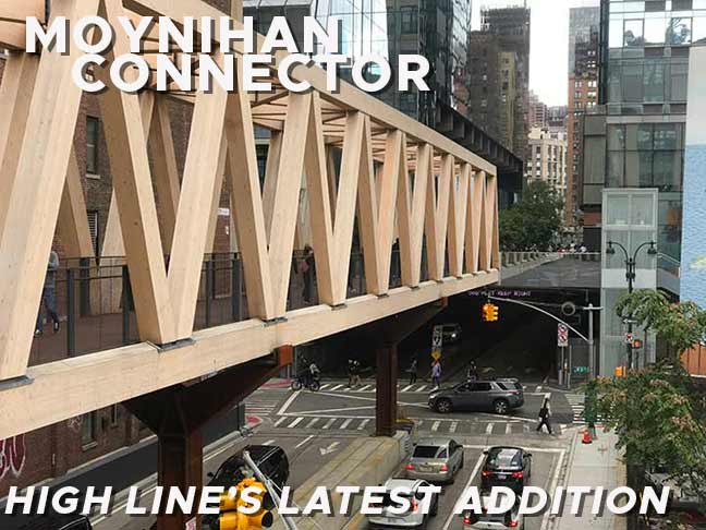
The northern end of the Moynihan Connector consists of a truss bridge elevated over Dyer Avenue topped off by a walkway with timbered bridge created with unfinished wood. It’s hard for me to fathom how all this unfinished wood will stand up to the harsh elements, rain, wind, etc. I was unable to get high enough to get a photo of the entire “Timber Bridge” but you get the idea from this Empire State Development image.
Dyer Avenue runs from West 30th north to West 42nd Street and has always been intertwined with the Lincoln Tunnel. In recent decades, portions of it have become an expressway built to facilitate moving traffic to and from the tunnel. The road was likely named for Major General George Rathbone Dyer, the chairman of the board of the Port Authority of New York and New Jersey, who approved the creation of the Holland and Lincoln Tunnels and passed away while the latter was under construction. The Timber Bridge runs atop the block between West 30th and 31st Streets.

Looking south on Dyer Avenue. You can see the Timber Bridge at right, which connects to the “Woodlands Bridge” on West 30th Street (see below). At left is a brick walkup “holdout” building that will likely be demolished. No doubt a developer has eyes on the parcel containing the walkup and the billboard. The Morgan Postal Facility can be seen at the rear.


Another legacy building, this time on the north side of the bridge on West 31st Street between Dyer and 10th Avenue. The bridge gave me an opportunity to get more “up close and personal” with the brilliant terra cotta work. Previously, I hadn’t seen the painted sign for M & G Metal Craft Manufacturing. According to the Indispensable Walter Grutchfield, the company was here for only one year: 1944. But its sign has lived on for 79 years and counting.

Though the Moynihan Connector opened in June 2023 plenty of people are still curious about it and there were healthy crowds on the first weekend in October.
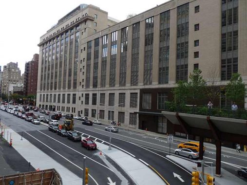
Here we see the giant Morgan Postal Facility on West 30th and the east end of the Woodlands Bridge on West 30th Street.
The Morgan, constructed in 1933, is now Manhattan’s main post office after the closure of the James Farley Building, at 8th Avenue between 31st and 33rd Street (its 8th avenue retail windows remain open) and dominates the SW corner of West 30th and 9th Avenue.
Looked at in any number of ways, the Morgan plant — named for Edward M. Morgan, the postmaster of New York from 1907 to 1917 — is a staggering example of federal logistics and enough to make one finally let go of one’s conception of the Postal Service as a third-tier operation mainly concerned with the avoidance of barking dogs. The plant itself is preposterously large: At 2.2 million square feet, it takes up an entire city block. It handles up to 12 million pieces of New York City’s mail every day. [NYTimes]
Long before the Morgan Processing and Distribution Center was built, this was the site of a depot for the Hudson River Railroad, a precursor of our Metro-North. President-Elect Abraham Lincoln arrived in NYC for a visit in the runup to the inaguration on March 4th, 1861, traveling from Springfield, IL by train beginning February 11th with stops in Indianapolis, Cincinnati, Columbus, Pittsburgh, Buffalo, Rochester, Syracuse, Albany, Poughkeepsie, Peekskill and then New York on February 19th.
Tragically, Lincoln’s next visit came after his assassination as his funeral train also left for Springfield from the depot.A plaque commemorates his funeral train stop on the 9th Avenue end.

The caption reads “Noah’s Ark at the Coachella Valley”. This is an art installation sponsored by the High Line.

The new Woodlands Bridge, which does without the wood trusses in favor of “custom-shaped precast concrete panels that can hold up to five feet of soil and be home to flowers, plants, and even large-scale trees. The bridge’s walkway is suspended over the planter soil, with perforations for rainwater, allowing for natural irrigation” according to Secret NYC. It crosses 10th Avenue, allowing views of a new playground at West 30th as well as the avenue’s Hudson Yards “wall of glass.”
We are on High Line original 1934 construction now, evident by the riveted metalwork on the fences. The West 30th Street spur over 10th Avenue has featured a number of successive art installations, with 2023-2024’s being “Old Tree” by Swiss sculptor Pamela Rosenkranz. The red hue is supposed to be evocative of human blood and tissue.
I should mention here that I have some issues with how the walkway on the High Line was constructed. The walkway features “grooves” that you can turn an ankle on if you’re not careful, and in particular the 30th Street spur has a couple of hidden steps; I was aiming my camera, completely unaware of them, when I saved myself from what could have been a severe fall. Just something to be aware of.
Besides the 30th Street spur, the High Line features numerous landings where seating and other public works have been installed. These could have originally contained layup tracks for freights (no passenger service ever ran on the tracks).
Here, the High Line begins its run south to the Meatpacking District and on weekends it is busy indeed with foot traffic, except in the coldest or rainiest weather. I’d say about 75% of it consists of out of towners. Sometimes, New Yorkers complain about tourists, but I have lived in NY my whole life, over 60 years, and I am a tourist in my own city. My 150+ live tours, and many online tours, owe their existence to tourism.
The High Line formerly featured sumptuous views of downtown Manhattan and Jersey City across the Hudson, but much of this has been eliminated in recent years by construction of high-rise apartment buildings on either side of the line, many in fanciful designs.
Another interesting exhibit can be found in this 4-sided exhibit on the High Line between 10th and 11th Avenues. Every newspaper shown here by artist Faheem Majeed was/is Black owned and operated.
For the High Line, Majeed presents Freedom’s Stand, an homage to the role of Black newspapers in the US. The work draws inspiration from a range of influential, community-driven work, including Chicago’s Wall of Respect and the Community Mural Movement, and emphasizes the importance of community-generated news and self-representation. Freedom’s Stand is named after Freedom’s Journal, the first Black-owned-and-operated newspaper in New York City, founded in 1827, which offered a counter-narrative to newspapers that attacked African Americans and encouraged slavery. The sculpture is modeled on the Dogon granaries of West Mali. The walls of the sculpture showcase headlines, articles, photographs, and advertisements from historical and contemporary Black newspapers, such as the ongoing South Shore Current in Chicago; these selections rotate monthly. [High Line]
At The Shed, the High Line abuts a walkway through Hudson Yards that goes to the (relatively) new #7 station at West 34th Street. To me, The Shed is the most interesting structure in the Yards. In fact, it is the city’s largest structure on rails. The Shed has a retractable shell that turns its performance space into a an outdoor venue, “The McCourt,”weather permitting. Unlike the glass boxes around it, here’s a truly sculptural building that is movable. It is creative in its appearance and purpose, designed by Diller Scofidio + Renfro and the Rockwell Group, the firms that worked on the High Line. In the fall of 2022, I had hoped to attend “Straight Line Crazy,” about the life and work of Robert Moses with Ray Fiennes as the traffic czar, but The Shed was sold out for it.
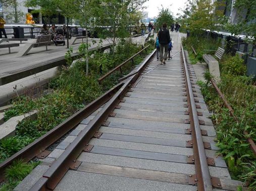
The High Line designers left some stretches of rails and ties in at certain spots along the route as a reminder of what was formerly here. The West Side Freight Railroad operated between 1934 and 1980 and its original south end was what was known as St. John’s Terminal near the Holland Tunnel bellmouth. The trestle was cut back to Gansevoort Street in the 1980s, but a short stretch inside the Westbeth Building at Bethune and Washington Streets is still intact.
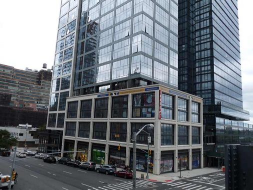
Even in new construction, I don’t mind square windows. Here’s the lower floors of the new luxury high rise 3ELEVEN, cleverly named as its main address is #311 11th Avenue. The new Hudson Yards and its satellite developments are far away from midtown, shopping and entertainment, but people who live here take black cars everywhere.
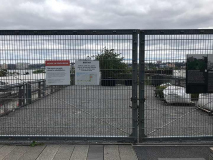
I didn’t expect the north end of the High Line between 11th and 12th Avenues to be fenced off (albeit with interesting historic signs) but the walkway that had been here, and opened in 2014, was considered temporary and a permanent one is being installed. It is supposed to reopen in early 2024. Fortunately I have already walked this stretch when it first opened.
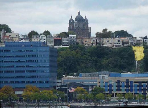
I used my zoom lens to focus toward the Monastery of St. Michael the Archangel in Union City NJ, seen from the High Line. (When I worked on West 29th for a few years from 1988-1991 I’d see this far -off apparition and wonder what it was.)
The Monastery and Church of Saint Michael the Archangel is a state and national historic place in Union City, New Jersey. Formally opened in 1869 and completed in 1875, the grounds of the complex are bounded West Street and Summit Avenue between 18th and 21st Streets. The small street leading to its front entrance from the east is called Monastery Place. At one time the largest Roman Catholic church in Hudson County, it has since became home to a Presbyterian congregation while part of the grounds are used for housing and education. wikipedia
The church was designed by renowned ecclesiastical architect Patrick Keely. It is now on “Ten Most Endangered Historic Places in New Jersey” list.
The “Yards” in Hudson Yards refers to the vast Penn Station railyards west of 11th Avenue. The Western Yard section of the Hudson Yards megacomplex will eventually be built here, on a deck that will cover three quarters of the railyards, which are expected to remain fully functional while the deck and high rise buildings supported by caissons drilled deep into bedrock, rise above them. By the mid to late 2020s, the view from here is guaranteed to be drastically different.
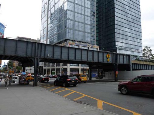
The High Line, built 1932-1934, crosses 11th Avenue and is by far the oldest structure in the photo. I have additional photos from this trip, but I’ll parcel them out in dribs and drabs later.
As always, “comment…as you see fit.” I earn a small payment when you click on any ad on the site. Take a look at the new JOBS link in the red toolbar at the top of the page on the desktop version, as I also get a small payment when you view a job via that link.
10/22/23

9 comments
The “holdout building about to be demolished” reminds me of when they used to
paint big white X s in every window of a building “about to be demolished”
A spaniard visiting NY for the first time once asked me: “Why? Why they do this?
But I could only shake my head and walk away.
I could be wrong, but I think the “Xs” were (and still are?) used to communicate to firefighters responding to incidents that the building is not occupied.
I lead tours on the Highline and just wanted to say how much I appreciate your articles. Striking as it is from the HL, I’ve looked out at St. Michael’s in NJ for awhile now (and even once tried to find it on the map) and it was great to know what it is and a little bit about it. Gonna head out there soon. Great article. Really appreciate your insight and all the details you tie in. Outstanding. Thanks!
There’s a lot of interesting graffiti along the way. There’s a grinning feline, on the HL, which also surfaces in in Porto, Lisbon. I wonder if it’s a copycat….!
Hi Kevin,
I’m a devoted fan!
Long before The Highline was a trendy spot to stroll, back in the early 1980’s, I played softball in Chelsea Park located on Tenth Avenue between 27th and 28th Streets.
It was a hell hole in those days; hookers galore, crack heads abounded and addicts shooting up and nodding on the cement stands, sometimes with needles still in their arms. The stands were located on the southeast corner of 28th and Tenth and the hookers used to use appliance cardboard boxes as their “Parkside Apartments”.
The ball fields were blacktop and a couple of times we had to dodge bullets fired from atop the Elliot Houses that ricocheted off the ground. Luckily no players ever got hit.
There was a sleazy bar located on the northwest corner of 28th and Tenth we used to retreat to after games and a deli was on the southwest corner. The deli used to deliver cold six-packs of Bud so we could quench our thirst after between double-header games.
We were a pretty good team and sometimes would attract fans. In the early 2000’s, when the area was assuming its current upscale re-emergence, ex-senator Bob Kerrey, who was president of The New School at the time, used to stop by and watch. A couple of times we talked him into coming into our dugout and have a brew. We’d tease him about being a pinch runner for us knowing that he couldn’t due to his loss of the lower part of a leg.
And The Highline at the time was nothing more than an old remnant of the industrial days of Westside of Manhattan.
This segment of FNY brought back fond memories.
Yes, the High Line. Mayor Dinkins actually wanted it demolished, as chunks of cement were falling down from its trestles at the time of his administration. CSX Transportation (the railroad),its owner would not allow this, as they owned the trestles, tracks, and rights of way. The preservationists then got involved, and turned it into a park now owned by the City of New York. To me, this is a complete waste. Even before all the high-rise development around it, the views from it were horrific – I used to try to walk it when it was not a park. You have much better views just walking along nearby Hudson River Park. What should have been done was to reuse it as a an actual mass transit spur from Bank Street to Penn Station, with a light trolley running on the rails of the trestles. People could commute above the hustle and bustle of Manhattan from the West Village to Penn Station and visa versa. Its current use is a complete waste of something that could have been a useful transit amenity for the city. Instead, you have tourists bumping and tripping over one another, so they can tell their friends back home that “they walked the High Line”. Glenn in Brooklyn, NY.
CSX would not allow transit on the structure as part of the sale. Would have made an excellent extension of the #7 Flushing LIne south to 14th Street.
Somewhere in the fuzzy back of my memory, I recall something in federal law that requires the ability to return the structure back to active rail use, if ever needed. This does not apply just to The High Line, but to many other abandoned rail lines that were turned into trails or parks. While this is highly unlikely, it had to be considered as part of the design.