I have long had a fascination with the land borders of New York City. I have traveled much of the “undefended” Queens-Nassau border, and did a multipart series in 2011. On that link you’ll find a synopsis of the complicated circumstances that led to the creation of Nassau County from eastern Queens in 1899.
To get a bit more precise, I also have a greater fascination for borders that are mid-block, when you walk or drive between counties between streets. This situation occurs (for one street) on the Marble Hill-Riverdale border as well as Riverdale-Yonkers, and Wakefield-Mount Vernon. It also happens in southeast Queens, in Rosedale-Valley Stream and Far Rockaway-Inwood. Otherwise, NYC’s borders are in water, or down the middle of streets like Eldert Lane or Cypress Avenue.
There’s also Little Neck-University Gardens, Nassau, which I’ll deal with today.

Why is the border midblock in many cases? Because when these long-ago borders were drawn there were no streets, just barns, cows and fields. Much of Queens ande Nassau were farmland until the dawn of the modern age (I make that when electric power was widespread but others will use different benchmarks. Above is an excerpt from an 1891 map. In 1891, everything shown here was in Queens. However, the border that exists today was there, between the Towns of Flushing and North Hempstead. Whan Nassau became a county in 1899, this became the dividing line of Queens and Nassau.
Few roads were in existence. I have marked the routes of Northern Boulevard and Little Neck Parkway, which parallels the border but managed to always remain in the town of Flushing. In the early 20th Century, the farms were sold off to development companies, who built new streets and homes. In some cases, farms became country clubs, which in turn became public parks and high school and college campuses.

Here’s an Open Street Map from 2024. I like Google Maps, but they are weak on showing political boundaries, like between counties. As you can see, the Queens-Nassau line cleaves Pembroke Avenue, West End Drive, Walden Avenue, Iowa Road, Concord Street, Bates Road and Oakley Place (though Nassau seems to claim it in its entirety; see below). Glenwood Street spends its entire length in Queens… except for four houses north of Northern Boulevard, which are in Nassau.
One block of Pembroke Avenue is in Queens, between Little Neck Parkway and Glenwood street a block south of Northern Boulevard. The remainder runs for several blocks in University Gardens.

Interestingly if we look at a Nassau County map University Gardens once had streets numbered Queens-style from 256th through 262nd Street that Pembroke Avenue ran through. At some time in the past these streets were given plant names such as Buttonwood, Iris and Aster. However, houses are still numbered as if the numbered streets were never renamed, with hyphenated Queens-style addresses. Other “incursions” of numbered Queens streets into Nassau County can be found in New Hyde Park and Elmont.
University Gardens itself is oddly named. It’s an upscale part of town with well-kept homes on tree-lined streets. It’s not named for a specific university, but from the University Golf Club that occupied the subdivision before it was residentially developed in the 1920s.

The twin-peaked William Van Nostrand House at Pembroke Avenue and 254th Street was built in the mid-1800s; before it was in the Van Nostrand family it had been owned by Capt. Valentine Peters, who ran a general store from part of the property. When Peters owned it the house was called “Old Oaks” as it was surrounded by large oak trees. Until 1929 the house stood on Northern Boulevard where the Little Neck Theater is today, and was moved here to accommodate the new building. The theater remained open until the 1980s, when its air conditioning system failed. Today the old theater building is home to a Greek restaurant and other businesses. A private housing development called Van Nostrand Court faces the old house.

“Old Oaks” in 1940.
Unfortunately, a little bird told me that the owner of another Northern Boulevard restaurant, Il Bacco, has purchased the property and desires to build a parking lot on the site. Since both Pembroke and 254th are narrow streets, the lot would most likely be accessible from the boulevard.
The Van Nostrand name will live on in the area. The rear of several houses face Pembroke Avenue, part of a private development called Van Nostrand Court with entrances on Glenwood street and West End Drive. I would be shooed out if I entered to take photographs. It was developed on the former William Van Nostrand estate.
A pair of homes on Glenwood between Pembroke and West End Drive. I am happy at Westmoreland Gardens, but I have always been fascinated with cottages. Though Little Neck has no Landmarks protection, it features tree-lined streets with eclectic designs.
In the northern end, east of Little Neck Parkway and north of Northern Boulevard, the Westmoreland Association building covenants have strict rules regarding what can be built. For example, each home must have no sidewalk fencing and needs to be above a specific size.

Pembroke Avenue looking east from Glenwood Street. Some of the older North Hempstead signs appear to be hand lettered. Contrast to NYC speed limit signs, which are gold colored and employ Highway Gothic lettering.
I conducted this walk on two pleasant evenings in late June, the last two before NYC was plunged into an extended period of heat and humidity (I got out anyway). I wandered “in and out” of New York City to notice and interesting infrastructural differences.
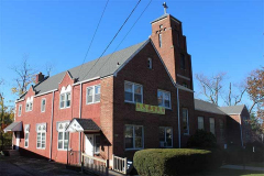
Christ Evangelical Lutheran Church was originally built at Glenwood Street and West End Drive in 1928. When the building was expanded in 1954, it incorporated the older building, but changed the facade. The building now co-hosts a Korean congregation, New York Beloved Church.
West End Drive sits mainly in Nassau, with a dead-end section east of Concord Avenue. Though some names in the area perplex me, West End Drive was likely named for its position at the west end of Nassau County. However, its section between Little Neck Parkway and Glenwood Street is actually in the east end of Queens.

A handsome Tudor cottage on Concord Avenue. When it enters Queens, Concord becomes a Street.
I have been in Nassau County regularly since 1992 and this has been the lighting standard on the side streets since then at least, a simple metal shaft with a post top light. In most cases the yellow sodium lamp is still there.
Once Walden Avenue crosses Concord Avenue, it becomes a Place. Here is exhibited two eras of Nassau County street signage, and a 1980s NYC green and white when it briefly enters New York City.
Walden Avenue may take its name from Walden Pond near Concord, MA, where author Henry David Thoreau (1817–1862) lived and wrote in minimalist natural surroundings. It’s possible the name was meant to conjure images of peace and tranquility to a better-read population in the early 20th Century. Unusually, his name was pronounced THO-ro.

A corner housed at Glenwood Street and Iowa Road is surrounded by poplar bushes. “Iowa Road” is a puzzling name to me, as in NYC most roads named for states have other roads named for states in the vicinity; Iowa stands alone. (Another instance is in Glendale, where you will find the dead end Indiana Avenue.)
Iowa Road matches its brother streets in a Pleasantville vibe. Midblock you will find a vintage Curb Your Dog sign from the 1960s. It may have been installed on its telephone pole by the owner of the home it faces.

Iowa Road comes in two pieces. The western piece is entirely in Little Neck and connects Little Neck Parkway and Browvale Lane.

Glenwood Street ends at the city line where Concord Avenue becomes Concord Street at Oakley Place and is maked by a very small British-style roundabout ungoverned by a stoplight due to light local traffic. There are a number of these scattered around the neighborhood.

If you look at the map above, the western end of Oakley Place is physically in Little Neck and should have Queens NYC street signage.

And, the Queen Anne on the corner should have Queens-style house numbering; however, it’s #3. Indeed all houses on Oakley Place boast Nassau County house numbering, unlike the other Queens-Nassau hybrid roads shown above, which have hyphenated house numbering no matter what county they’re in.
Oakley Place still boasts a 1970s-style Westinghouse OV-16 Silverliner and General Electric lamp fixtures, one apiece. I will have to stop by at night to determine if they are sodium or mercury.
Nassau County is not as manic about changing out lamps for modern LEDs. Borth Northern Blvd. and Jericho Turnpike employed a wide variety of classic sodiums and mercurys until 2021 or so. They got the job done. A couple of incandescent Gumballs are still on Northern, though I’m not sure they work.
Oakley Place ends at Westminster Road; both are lined with Tudors. Westminster Road is two-way on occasion and is the sole connector, other than busy Lakeville Road, between University Gardens and Lake Success, which is much more suburban in aspect, with wider lawns and no sidewalks.
Speaking of sidewalks, Bates Road doesn’t have much in the way of them either, as the road is a direct connector with the Long Island Expressway from its west end at Little Neck Parkway. Nevertheless, it’s lined with private homes.
Walking west on Bates Road, it’s easy to spot that undefended border with Queens. The road gets rutted, the center stripe disappears, there’s a house numbered #1, a Donald Deskey lamppost and a Welcome to Great Neck sign in a variety of signs. Plus, a sidewalk appears, like magic.
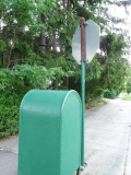
Going deep into infrastructural weeds, here’s an unusual stop sign and relay mailbox at Concord Street and Bates Road. Most relay boxes are painted olive or khaki, but this one is bright green. The stop sign looks brand new, but I’ve never seen a pole this old and rusted with a knob at the apex. At one time, maybe all stop sign poles looks liek this.

Perhaps the second handsomest building in Little Neck, next to PS 94 at 42nd Avenue and Little Neck Parkway, is the Church of Jesus Christ of Latter-Day Saints, 254-10 Bates Road between Little Neck Parkway and Concord Street. Though the Mormon Church seems to be associated with the public imagination as centered in the western states, the faith was founded by Joseph Smith in western New York State. The faith breaks from other sects of Christianity in many ways, most importantly, it holds that God the Father and the Son are separate persons; for this reason, the Mormon Church is called non-Trinitarian.
The facility stands on the former site of the Little Neck School (1865-1914) which was supplanted by PS 94 (see above) on Little Neck Parkway and 42nd Avenue in 1914. The old school was home to the Powers Chemical Co. for several decades until the temple was constructed.

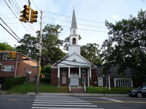
The nondenominational Community Church of Little Neck, Little Neck Parkway and West End Drive, was organized in 1925. They initially met in “The chapel”, an 1866 church built by the Little Neck Union Chapel Society.
As always, “comment…as you see fit.” I earn a small payment when you click on any ad on the site. Take a look at the new JOBS link in the red toolbar at the top of the page on the desktop version, as I also get a small payment when you view a job via that link.
7/14/24


12 comments
Personal lots are split too. Owners pay proportional taxes to both NYC and Nassau.
How ironic: My daughter belonged to a Christian Endeavors group that met at the Community Church. Community Church of Little Neck is located near an LDS church. In 2005, a year into my retirement, we relocated to AZ. In Little Neck an LDS church seemed remote & exotic. However, as soon as we settled into our new home in San Tan Valley we were virtually surrounded by LDS churches. We learned that LDS would build one church for a certain amount of people in the “ward” as they call it. We live down the street from one & within one mile from another which is located near the Johnson Ranch HOA office. Plus, not far from there is another LDS structure which is larger & more ornate; it serves some type of administrative purpose. I realize now that the LDS church in Little Neck was a harbinger of things to come in our lives even though we haven’t become Mormon adherents..
We have some of these crazy boundaries in NJ too, small residential lots cut in two by diagnonal own lines. The rule seems to be to pay property tax by the street address’s town. Using a street as the boundary seems simpler, but I know a street near me that has multiple potholes on on one side only, since only one town cared to patch them!
Crazy boundaries include sections that were for whatever reason, not claimed by the “rightful” town, such as High Bar Harbor as part of the Long Beach Township which should really be Barnegat Light (don’t get me started on Long Beach Township on LBI being in multiple sections), and two streets that belong to Toms River instead of Lavallette!
I am quite familiar with the Great Neck-Little Neck area, as I spent most of my childhood years on the Nassau side of the border. Once in Nassau, the motorist or cyclist or pedestrian is hit with a variety of streetlamps and street signs, because of the plethora of government entities responsible for street maintenance and lighting. Starting at the top, Northern Boulevard and other similar arterials, such as Jericho Turnpike are NY State roads. Others such as Lakeville Road and Middle Neck Road, are Nassau County roads. Finally the lowest levels are the Town of North Hempstead unincorporated areas, and the various small villages, which are particularly numerous in the Great Neck area. For example, the photo that says Welcome to Great Neck is actually in a unincorporated part of Town of North Hempstead, while nearby Lake Success, covered in 2020 on FNY, is an incorporated small village.
The three unifying factors in the Great Neck area are the school district, which goes from Kings Point all the way south to Hillside Avenue, the US Post Office, and the LIRR station, which serves the entire area,
By contrast, when crossing into Queens the traveler is met with a uniform set of street lamps and street signs. Years ago, the dark brown Covingtons immediately told me, “you’re in Queens.”
Two questions: I wonder if the street type changes because there already exists a street name in that town? That is, Walden Avenue becomes Walden Place because there already is a Walden Avenue somewhere in North Hempstead?
And, are there any houses cleaved by the border?
I think thats the neighborhood of Patricia’s Pub on Northernmost Blvd.Down the street was
Rosie O’Grady’s Good Time Emporium.
In southeastern Queens the line of demarcation changed considerably.
When New York City was expanded to five boroughs in 1898 a large portion of the Town of Hempstead was included. This would entail the city line extending from Jericho Turnpike in Floral Park south to the Atlantic Ocean. More of Floral Park would be in Queens, as well as Elmont, much of Valley Stream, Inwood, Cedarhurst, Lawrence and Lawrence Beach. (As well as, obviously, the Rockaway Peninsula.)
Apparently, enough residents opposed this that they were able to do what so far Staten Island has not, and that is secede from the City of New York. In 1899 legislation introduced by Assemblyman G. Wilbur Doughty (R-Inwood) and signed by Gov. Theodore Roosevelt removed a 15-square mile strip from the city, with a population of about 2,000, and placed it into the new Nassau County. (The Rockaways were to remain in NYC.)
So for about a year, the City line was about a mile to a mile and a half east of where it is today.
So could that explain the streets numbered 256 to 262? That they were originally in Queens?
They were in Queens, but left it in 1899, long before the streets were built.
The neighborhood you wrote about, basically east of Glenwood Street and off of Pembroke Avenue, was developed by Frank Droesch in 1927, and was named Little Neck Park. I remember as a child in the 1960s, the north/south streets were still numbered and not yet named. I don’t blame them at all wanting to drop the impersonal numbers for more descriptive names. It is funny how in the neighboring Douglaston Hill (Historic District) and Douglas Manor (Historic District) neighborhoods they did a similar thing, except here they just went back to their original names before the Queens Topographical Bureau had taken them away.
I lived on Walden Place from1965 to 1972. This area, including Pembroke Ave. is not really in University Gardens, which is a beautiful enclave unto itself. I was a member of the Community Church of Little Neck. The original chapel was to the extreme right of the building, later the parish hall. I understand the church itself has recently undergone a reorganization. Several houses on the Walden Ave. are in Nassau. They fell into the Great Neck School district. As a result, children on the east end of the street went to Great Neck Schools and on the west end to NYC schools.