

BY SERGEY KADINSKY AND KEVIN WALSH
FROM late 2024-early 2025, I decided to walk Manhattan’s lettered avenues from A to D (Brooklyn has the full panoply, with a few exceptions, from A to Z, while Staten Island has an unexplainable and incongruous Avenue B in Port Richmond (see it on this FNY page). While today’s Manhattan’s Avenue B runs only from East Houston north to East 14th, it did continue northward at one time — way up north, at the east edge of Yorkville, where Manhattan Island widens just enough to allow two north-south avenues east of 1st Avenue. One, York Avenue, used to be Avenue A, and an Avenue B was built between East 79th and 90th Streets. In 1890, a year that saw a lot of street naming changes in Manhattan (West End, Columbus, Amsterdam Avenues were all created) Avenue B became East End Avenue. Avenues C and D, though, have always been confined to the East Village.
This page is different from its three predecessors in that I did not make a recent pilgrimage to Avenue D; but Sergey has, and I am relying on his notes and photos, as well as some pertinent Google Street View images.
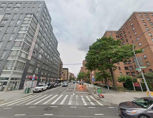
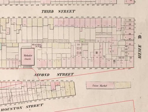
Avenue D begins at the intersection of Houston Street, Columbia Street and East 2nd Street. Back in 1835, the city organized a set of public markets for vendors, with Essex Market as the most enduring example. At this corner was the Union Market, which shared its building with a police precinct.

The market suffered a fire in 1836 in which cartoonist Henry Robinson accused the firemen of standing by idly. The officers hated having their dorms above a live poultry market and in 1921, they relocated to another building. I could not find any photos of the Union Market, so above is a map from 1853 showing its location. I added lines showing the widening of Houston Street in the 1930s, which resulted in the demolition of this old market.
The Lillian Wald Houses , between East Houston, East 6th, Avenue D and the Franklin D. Roosevelt Drive, are one of many high rise, lookalike housing projects built at the east end of the East Village in the mid-20th Century to replace the tenements that formerly stood on the east-west numbered streets, which held thousands of living spaces, but many without heat or hot water. Wald Houses comprises 16 identical towers designed by architects Frederick Lee Ackerman and Lafayette Anthony Goldstone. The latter is better known for his uptown apartments. The first apartments of Wald Houses opened to tenants in 1949.
In 1893 Lillian Wald (1867-1940) started the Visiting Nurse Service with philanthropist Jacob Schiff, an institution that is still going strong today. Wald also started the Henry Street Settlement, an organization bringing a wide range of arts and social services to its community. The Settlement has grown in its over-100 year history to encompass 18 buildings — and it continues to expand. Oddly, both Lillian Wald and Jacob Schiff had NYC thoroughfares named for them, but both have fallen into disuse: Lillian Wald Drive had been East Houston Street between Avenue D and the FDR Drive, while the middle lane of Delancey Street between Bowery and The Williamsburg Bridge had been known as Schiff Parkway.
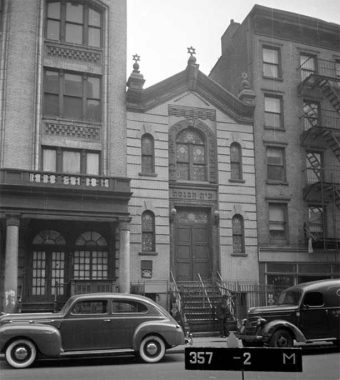
When NYCHA built the Lillian Wald houses, a sizable chunk of the neighborhood was razed, wiping away history in favor of uninspiring brick towers in a park. Among the condemned buildings was Chevra Achim Bnei Isaac, a Hungarian synagogue that was typical of the Jewish Lower East Side, where immigrants from the same places banded together to form synagogues and benevolent associations. Next to this synagogue was Lafayette Casino, which wasn’t a gambling den but a catering hall for weddings and other public gatherings.
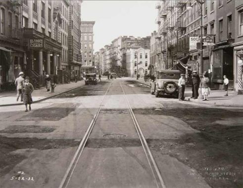
Looking south on this block in a 1932 photo from the Manhattan Borough President’s collection, Lafayette Casino is on the left next to a cigar shop. Across the street is a striped barber shop pole. Houston Street has not yet been widened and had a synagogue of its own on the corner, representing landsmen from Sighet, Romania. The streetcar track here was later replaced by the southbound M14D bus which runs from Chelsea to the Lower East Side.
Note the script Fletcher’s Castoria ad and Type F lamppost.
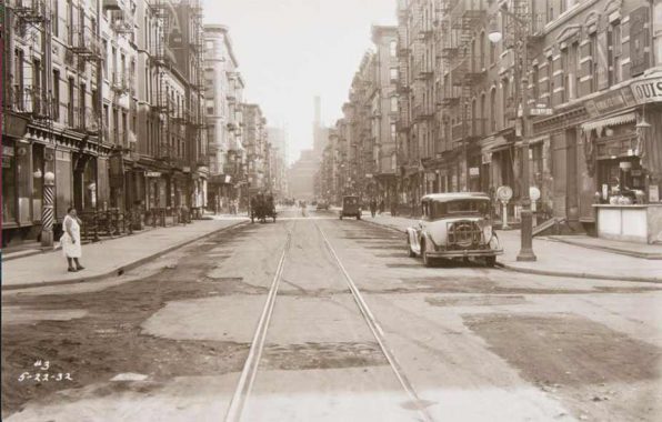
Looking north on Avenue D in 1932, the Con Ed power plant on 14th Street frames the view. A handful of cars were parked by the curb but overnight street parking would not go into effect until 1954. A lone horse pushing a carriage serves as a transportation relic destined to disappear.

The barbershop on the left is now a bodega and the entire right side of Avenue D was demolished for the public housing projects.
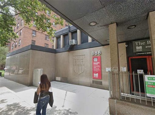
Only East 6th and East 10th Streets proceed east from Avenue D to the FDR Drive. At #888 East 6th you will find Boys and Girls Republic, formerly Boys Brotherhood Republic, an organization sponsored by the Henry Street Settlement providing youth (ages 6-19) with after-school homework help, tutoring, computer classes, recreational activities, evening sports and recreation program for youth (ages 12-19), and summer day camps.
East 6th Street is the undefended border between the Lillian Wald Houses on the south and Jacob Riis Houses to the north.
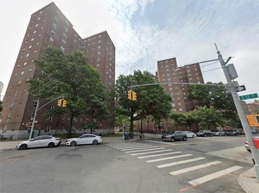
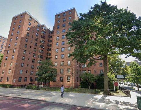
The Jacob Riis Houses, mostly indistinguishable from the Wald Houses, are named for the Danish-born crusading journalist and photographer Jacob Riis (1849-1914) made his home in Richmond Hill, Queens, beginning in 1886. In 1887, Riis photographed the squalid, inhumane conditions prevalent in New York City’s tenements, and his 1890 book “How The Other Half Lives” has become an influential text to the present day. His cause was taken up by Police Commissioner Theodore Roosevelt, who encouraged legislation that would help ease the burden of NYC’s poorest. Additionally, as one of the most famous proponents of the newly practicable casual photography, he is considered one of the fathers of photography due to his very early adoption of flash in photography.
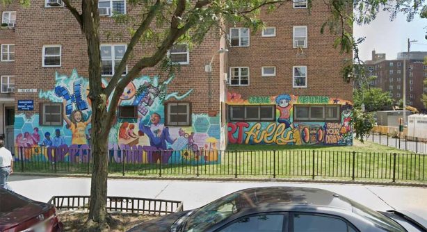
North of 6th Street, the city built 19 towers of the Riis Houses. Seeking to soften the architectural monotony of these towers, the nonprofit Thrive Collective and young residents painted a mural on the corner of 11th Street and Avenue D in 2024.
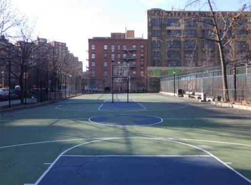
Near the north end of Avenue D, Dry Dock Playground was developed by the city as an urban renewal project. A year earlier, the Department of Housing Preservation & Development (HPD) took a photo of this block. Robert Moses saw this as another blighted block deserving of demolition, but the photo shows a row of small businesses here. By this point, the once-Jewish neighborhood became largely Puerto Rican.


Szold Place is a curious two-block road between East 10th and 12th Streets east of Avenue C. Until 1951, when it was surrounded by factories, mills and iron works, Szold Place was known as Dry Dock Street, after a nearby dry dock at the East River. These days, Szold Place is fairly drab, lined by nondescript high rise apartments and PS 34. The old name, however, lives on at Dry Dock Playground, on Szold Place north of East 11th. There was also Dollar Dry Dock Savings Bank, established in 1848 and liquidated in 1995 after absorption by Emigrant.
The name commemorates Henrietta Szold, the founder of the Jewish Zionist women’s organization Hadassah in 1912.
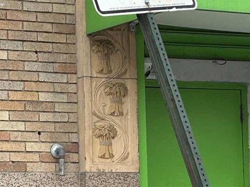


Keepers Storage, #444 East 10th, is housed in an Art Deco-era building festooned with interesting terra cotta panels. It was built in 1928 as the Wheatsworth Bakery and is a landmarked structure.
From its Landmarks Preservation Commission report:
The Wheatsworth Bakery Building was constructed in 1927-28 to the designs of J. Edwin Hopkins, a specialist in the design of industrial bakeries. This Art Deco/Viennese Secessionist style factory building features a granite base, light-colored iron-spot brick, large multi-pane pivot steel windows and polychrome terra-cotta friezes with green circles at the base and the parapet. The linear ornamentation of the terra cotta friezes with their restrained, geometric designs is characteristic of this style of architecture…
|
The building was built by Wheatsworth, Inc., the manufacturer of whole wheat biscuits and flour and inventor of the Milk-Bone dog biscuit. The company was formed under the name F.H. Bennett Biscuit Company in 1907 by Thomas L. and Frederick H. Bennett to market whole wheat products. Wheatsworth was a successful food manufacturer with plants in Manhattan and Hamburg, New Jersey. According to the New York Times, the new factory, which was built adjacent to their existing Manhattan plant, would triple the capacity of the company’s baking activities. National Biscuit Company acquired Wheatsworth in 1931. The company, now known as Nabisco, sold the rights to the Milk-Bone dog biscuit in 2006 but continues to make Wheatsworth Crackers.
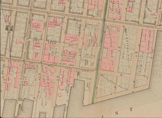
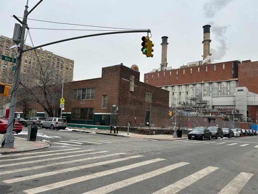
The history of gas production in this section of Avenue D extends far back into the past, as seen on this map from 1879. A map from 1853 shows this district dominated by iron works and the dry docks that inspired the street’s name. At the time, Avenue D ran north to 16th Street. As the power plant expanded and with security considerations in mind, the street now terminates at 13th Street. The streetcar tracks on 10th Street connected to the Greenpoint ferry. Today, the M8 bus route is this trolley’s successor.
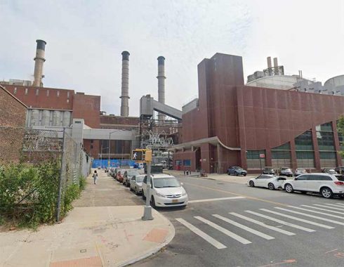
I don’t know much about the Con Edison power plant at the east end of East 14th, east of Avenue C; Con Ed guards their facilities like Fort Knox (rightly enough) and East 14th has been closed east of Avenue C for several years.
The East River Generating Station is a 43,000-square-foot, 660-megawatt oil and natural gas-fired power plant located along the East River at 14th Street in Lower Manhattan.
|
East River Station was built as a coal facility in 1926 by the New York Edison Company. The plant’s original six-story boilers were so large that one of them accommodated a 100-person luncheon held in honor of the plant’s opening in 1926. Queen Marie of Romania dedicated the plant by flipping the switch that started the 100,000-horsepower turbine generator, prompting a ConEd official to note that the queen had, “released the energies of one machine that could supply more than three times the electricity at present used by all of Romania.” [Belluck Law]
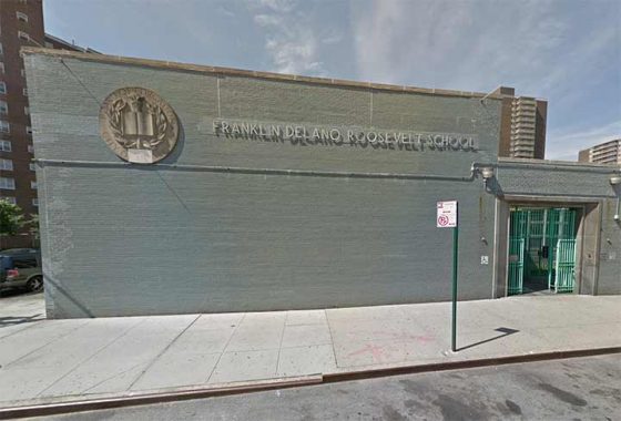
PS/MS 34, the Franklin D. Roosevelt School, serves children from the Far East Village including the Riis and Wald Houses. It’s not to be confused with Franklin D. Roosevelt High School on 20th Avenue in Mapleton, attended by various cousins.
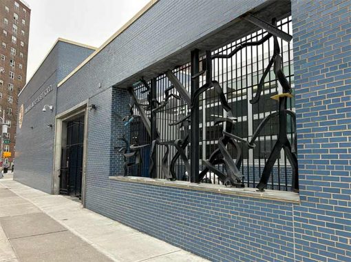
FDR was built in 1953 during the modernist period of school design, led by superintendent Michael Radoslovich. He brought in the renowned firm Harrison & Abramovitz whose local works include the UN headquarters, Hall of Science, and Lincoln Center. At its entrance, sculptor Mary Callery created Fables of La Fontaine, a composition of metal beams, washers and nuts evoking three children’s fables, The Fox and the Crow, Frog and the Bull, and Three Thieves and the Donkey.
Recent artistic additions at this school are the murals I am Loisaida on its exterior wall in 2016, Aim High in 2021 on the schoolyard pavement, and Make Your Mark in 2022 on a large canvas.
On the opposite side of E. 12th Street at Avenue D, the shuttered Saint Emeric School stands for now, but it was sold by the Roman Catholic Church to a residential developer in 2012. It feels like matching bookends as Avenue D began with a Hungarian synagogue and ended with a church/school named for the son of Hungary’s first Christian king. This school was a product of its time, with its student body living in the NYCHA projects and nearby Stuyvesant Town.
Its Hungarian name was given to express solidarity with Cardinal Joszef Mindszenty who was imprisoned by communist authorities in 1949. Architecturally, it is a nondescript structure contrasting with the Gothic Revival of older Catholic parishes. Among the alumni of this school is Robert Mulero, who documents every species and genus of lamppost across the city.
In recent years, Catholicism across the city has been declining in membership, with many schools and churches closing their doors. In 2013, St. Emeric was merged with the parish of St. Brigid, which also included the former parish of Most Holy Redeemer, and the former Parish of the Nativity, a consolidation of its East Village faithful.
The Saint Emeric property sold for $35 million in 2024 to an affordable housing developer. With its long industrial history predating the church, the soil will be tested and cleaned before construction begins.
As always, “comment…as you see fit.” I earn a small payment when you click on any ad on the site.
2/9/25
5 comments
The photos taken in 1932 which have a track in the middle of the street raise an interesting question: Did a streetcar line ever run here? I see no overhead wire and there obviously is no slot in the middle for the third rail, which was the common way streetcars were powered in Manhattan in that era. It may have been a horsecar track that had never been pulled up or covered.
In the photo of Avenue D in 1932 looking North, the horse is pulling, not pushing the cart (horses do not push carts). Also, the lack of wires or a conduit to power the streetcars is interesting. Either the streetcars had already been replaced, or they were battery powered, as a few short lines were (the batteries were charged at the end of each run).
Cool beans! Have you ever covered Attorney Street?
https://forgotten-ny.com/2018/07/streets-lower-east-side-part-3/
I wonder if this Lafayette Goldstone was related to a Tobias Goldstone, also an architect, who designed at least 2 synagogues in Brooklyn (maybe 3, 4).