

I have been thinking about the Interborough Express, a proposed mass transit line connecting Bay Ridge and Jackson Heights running mainly along the rights of way of the NY & Atlantic RR (which operates on the Long Island RR Bay Ridge Branch) and the NY Connecting Railroad in Queens. As circumstances would have it, I have actually ridden the Bay Ridge Branch from Fresh Pond Yards to Bay Ridge in 2009. The trip was possible via the efforts of Joel Torres, Chief Transportation & Commercial Officer of the New York and Atlantic Railway, a longtime ForgottenFan who offered to pilot an engine down the now-little used road all the way from Fresh Pond to Bay Bay Ridge. Additionally, I have walked the New York Connecting RR on a day when freight service was absent with the New York Connecting Railroad Society in 2004.
Though I have been on the trackage proposed for the new line, which would be light rail (see the Hudson-Bergen Light Rail and Newark Light Rail, the closest examples to NYC, to see what such service would resemble). NYC has not had light rail transit since the 1950s, when the last streetcar lines were eliminated, and the IBX would not have any street-running trackage. a short stretch had been planned along Metropolitan Avenue and 69th Street in Middle Village, but objections from area residents prompted the MTA to change plans and build a short tunnel beneath All Faiths Cemetery.
Is there a clamor for a mass transit line between Bay Ridge and Jackson Heights that would bypass Manhattan? I have my doubts, but the MTA says the line would provide transfers to 17 subway lines and several bus lines. However, the true driver of the project which nudged it toward the front burner is the addition of thousands of new housing units in the line’s vicinity. By its latest estimation the MTA expects the line to be completed in the mid-2030s. I am presently 68 and estimate my chances of actually riding it as 60/40 at best.
No properties have to be demolished for the line, but the MTA needs to negotiate with the NY & Atlantic and NY Connecting Railroad for track space. Both remain active freight lines and by law, freight and light rail must operate on separate tracks. No doubt the existing right of way will need to be widened to accommodate new trackage.
Title image: Juniper Park Civic

Since I have already ridden or walked the IBX length, I decided today to show existing conditions at each of the 19 proposed stops of the line. In the 2030s, these locations may be considerably busier, with stations and added housing units.
Brooklyn Army Terminal


The west end of the IBX would be at the Brooklyn Army Terminal, a location where Elvis Presley boarded a ship that took him to Germany for his compulsory Army service. Once a huge part of Brooklyn’s maritime manufacturing scene, it was completed by famed architect Cass Gilbert in 1918 and is situated between 2nd Avenue, the waterfront, 58th Street and Shore Parkway. The waterfront is less active now, but BAT is still a bustling, imposing complex occupied now by private businesses and manufacturers.
The station location is where the roadbed of 65th Street would be. The closest bus route is the B-11, which terminates at a ferry at 1st Avenue and 58th Street. The ferry slip can move here, if the Army Terminal owners permit it, or the bus can be routed through the complex here. Either way would require some negotiations.
4th Avenue
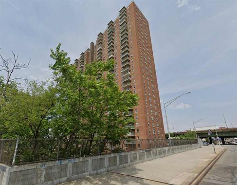
The Shore Towers complex, Bay Ridge’s tallest buildings when completed in the early 1970s, dominate the view of where the IBX 4th Avenue station would be. A connection to the B9 bus could be easily made here, but not so simply a connection to the R train at Bay Ridge Avenue R train station four blocks away.
8th Avenue
My home station at times from 1982-1988, the N train station at 8th Avenue and 62nd street offers easy transfers to the subway and the B-70 bus. The IBX would parallel the N (Sea Beach) subway between 4th Avenue and the next stop after this at New Utrecht Avenue.
New Utrecht Avenue
There’s a multi-block gap between 8th Avenue and the next proposed stop at New Utrecht Avenue, which offers connections to both the N and D (West End) subways. the nearest bus is the B9, two blocks away on 60th Street. There are no Street View photos of the stationhouse, but the depicted scene is nearby.
From here, the IBX abandons the Sea Beach open cut and uses the NY & Atlantic open cut going east.
McDonald Avenue
Another el, this one for the Culver line F train, is encountered at McDonald Avenue. The B-11 bus, running along Avenue I, is nearby.
The old Prospect Park and Coney Island line, constructed as a surface railway beginning in 1875 by Andrew Culver. It was purchased by the Long Island Rail Road in 1892; Brooklyn Rapid Transit, the precursor to the BMT, acquired the route in 1899 and it was elevated from the old Fifth Avenue El to Coney Island in 1919-1920, with surface tracks being used by trolleys until 1956 and then by the old South Brooklyn Railway freight line until 1978.
East 16th Street

The IBX meets the Brighton Line, serving B (express) and Q (local) trains, just south of the Avenue H station, which is served by an ancient building that was once the T.B. Ackerson real estate office. The B68, B9 and B6 buses are nearby, but a few blocks away.
The Brooklyn, Flatbush and Coney Island Railway (the Brighton Line) began service in 1878, originally running from the Prospect Park entrance at Flatbush and Ocean Avenues south to the Brighton Beach Hotel, built near the water’s edge. By 1897 it was connected with the Fulton Street El; the connection survives today as the Franklin Shuttle).
Here the LIRR Manhattan Beach Branch turned south from the proposed IBX route, parallelling the BF & CI south into Coney Island.
Flatbush-Nostrand
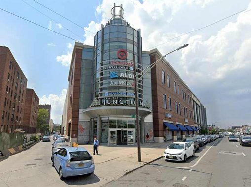
The Flatbush-Nostrand IBX station is in a propitious location as it would be at a southern Brooklyn shopping and transit nexus known to locals unofficially as the Junction. The IRT #2 and 5 trains terminate here and multiple express and local bus lines pass by including the B44, B6 and Brooklyn’s lengthiest, B103, which connects downtown with Canarsie.
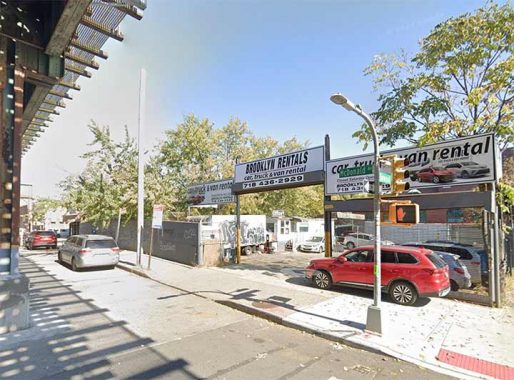
Utica Avenue
The IBX would be elevated for a few stops in East Flatbush and East New York. Here things get a little tricky as far as transit goes, since a couple of stops are in a subway desert and a no-man’s land of auto repair shops, manufacturing and warehousing. This is likely where the proposed housing would be built, but to me it seems like an inhospitable region. There have been proposals for a Utica Avenue subway that have never borne fruit. Instead the road hosts and express bus line, the B46.
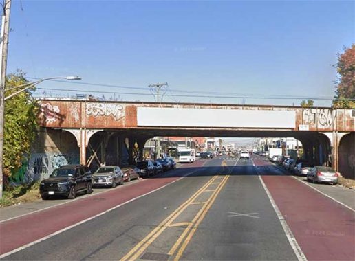
Remsen Avenue
The NY & Atlantic and proposed IBX is bridged over Remsen Avenue in northern Canarsie in slightly better location than the Utica Avenue station. It passes the Brooklyn Terminal Market, which now does a brisk wholesale and retail business. The B17 bus plies the avenue.
Dedicated by the late Mayor Fiorello LaGuardia, the market opened for business in 1942. Located on Foster Avenue between East 83 and East 87 streets, the market has earned a fabulous reputation for offering excellent quality at great prices. In fact, after 66 years of both retail and wholesale business, the Brooklyn Terminal Mark had virtually become a Canarsie Landmark. Brooklyn Terminal Market Online
Linden Boulevard
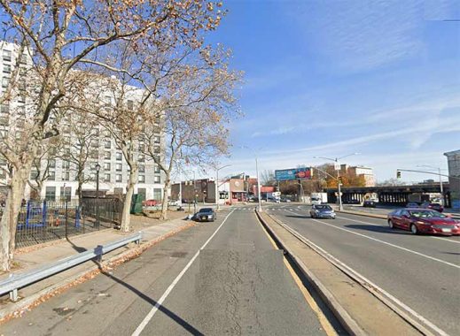
Here the IBX would turn north and use an elevated trestle that descends into an open cut in East New York. It parallels the BMT Canarsie L train and a transfer station would presumably be built here at the Linden Boulevard station. The nearest bus is the B15 on New Lots Avenue.
In the colonial era, New Lots was settled several years after Flatbush was by Dutch immigrants. After all fields in Flatbush were claimed, several families moved east into untilled land, calling the new fields “New Lots,” in contrast to the old lots in Flatbush. The town of New Lots broke away from Flatbush and had town status all its own until absorbed by the City of Brooklyn and later, Greater New York.
Livonia Avenue
Though the elevated #3 train, on Livonia Avenue, and the BMT L train, running north-south in an open cut, cross here, the MTA never built a transfer between the two, honoring an out of station transfer in the early 2020s during the pandemic. Presumably the IBX would freely transfer between both. There are no obvious bus transfers except to the B14 a couple of blocks away.
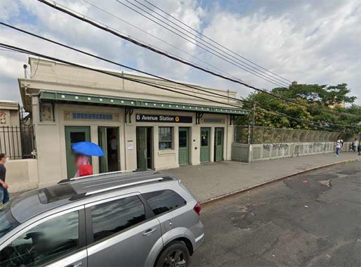
Sutter Avenue
The proposed Sutter Avenue station is just 3 blocks to the north, but will presumably transfer to the Sutter Avenue L train station shown here. Once again, the B14 bus also runs here.
Atlantic Avenue


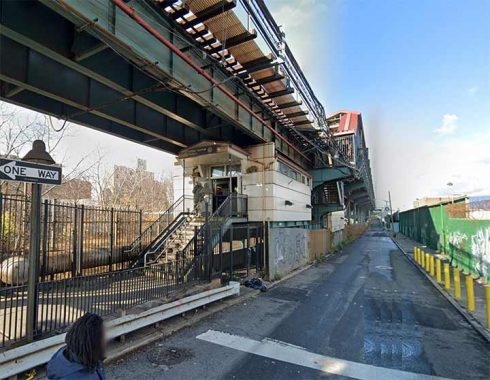
The only remaining platform from the old New York and Manhattan Beach, East New York was in passenger operation from 1877-1924, with this concrete center platform in use beginning in 1915. It was in use for between just 8 and 9 years before service was eliminated! The East New York platform, while not in use for over 85 years, is occasionally fitted to double as a railroad/subway platform for TV shows such as “Law & Order” and “Succession.”
The NY & Atlantic here enters a lengthy, spooky tunnel paralelling the cemetery belt.
This would be a junction for A, C, J, L and Z trains as well as the Long Island Rail Road Brooklyn branch and the B20, B25 and B83 buses.
Wilson Avenue
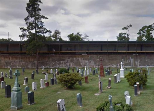
The double decker BMT L train Wilson Avenue station is seen here from Most Holy Trinity Cemetery. the southbound is in the open air, while the Manhattan-bound is in a subway in a feat of BMT ingenuity in 1928. The new IBX station would presumably be above ground. A transfer would be available to the B60 Wilson Avenue bus.
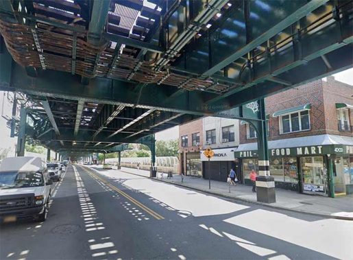
Myrtle Avenue
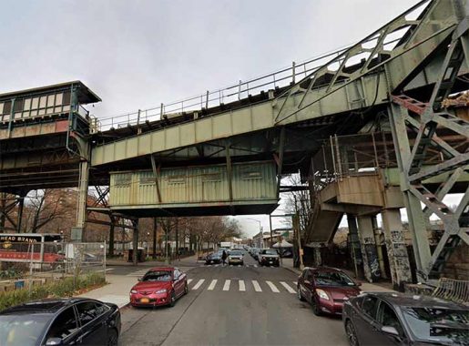
Myrtle Avenue at 61st Street is in a bustling area where Ridgewood meets Middle Village and would also be a natural location for a transit station. The line is elevated here. Numerous bus lines, including the Q55, connect Ridgewood with points in all directions. Myrtle Avenue was constructed as a plank road from the downtown Brooklyn area out to Jamaica in the 1850s. If you look at a map, it cuts across the NE-SW oriented Ridgewood street grid, which was built after the road was extended through.
Metropolitan Avenue
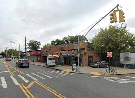
The IBX would transfer to the east end of the M train at All Faiths Cemetery and the Rentar Plaza shopping area at Metropolitan Avenue, as well as the Q54 and Q67 buses. This is the location where a short tunnel under the cemetery would be built to connect the light rail to NY Connecting Railroad trackage.
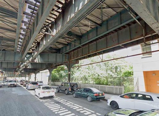
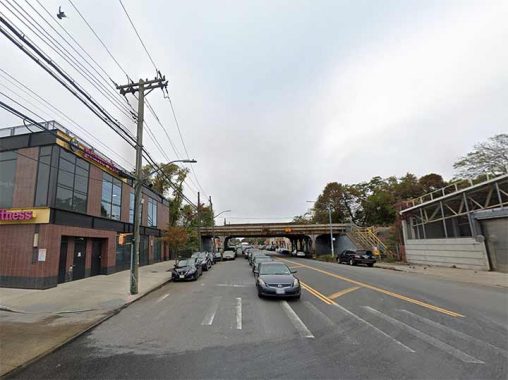
Eliot Avenue
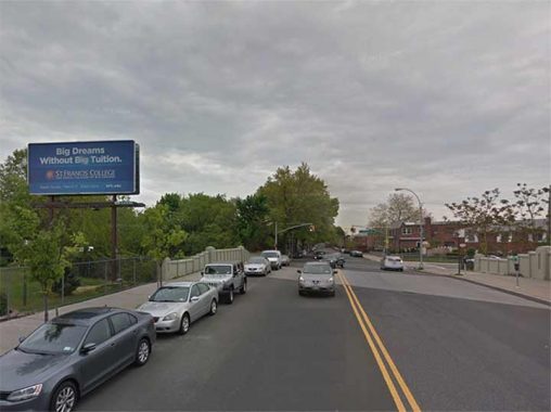
Eliot Avenue, seen here at the bridge over the NY Connecting RR Lutheran Avenue and 75th Street, roars through Middle Village as one of the few continuous auto northeast routes through the neighborhood. It connects Metropolitan Avenue and 60th Street with Woodhaven Boulevard and 86th Street at the LIRR main line overpass. A short one-way section connects the other side of Woodhaven Boulevard with Queens Boulevard at the Long Island Expressway.
The road was built piecemeal between about 1915 and 1938; at its completion, it was nicknamed “World’s Fair Boulevard” as prior to the construction of the Queens Midtown Expressway it funneled Brooklyn motorists on Metropolitan Avenue toward Nassau Boulevard (which would become the LIE) which took you directly to the fairgrounds in 1939-1940.
Eliot Avenue is named for Walter G. Eliot, an engineer in the Queens Topographical Bureau who named the streets in the area before the decision was made to number Queens streets in place of the old names. For a few years, Eliot Avenue was 61st Avenue, until it was changed back to Eliot. Today, there is no 61st Avenue in Queens west of Douglaston Parkway in Glen Oaks.
The road was built at the line separating Mount Olivet from Lutheran (All Faiths) Cemetery, and narrows to a single lane of traffic each direction through the cemeteries.
We’re in another “subway desert” but Eliot Avenue is served by the Q38 and the Q67 on 69th Street.
Grand Avenue
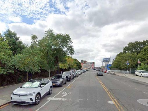
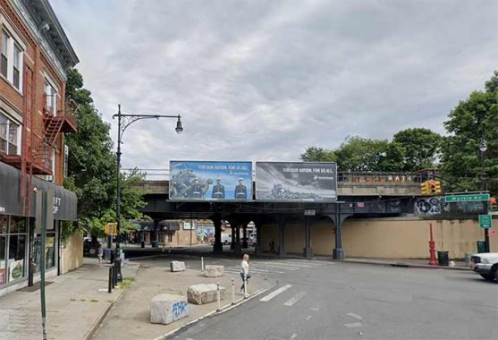
The proposed Grand Avenue IBX station is at Elmhurst Park, formerly the location of the Elmhurst Gas Tanks, on Grand Avenue, a connector between Williamsburg, Brooklyn and the heart of Elmhurst, serving the Q58 bus to Flushing.
Roosevelt Avenue
The IBX northern end is at the #7 train on Roosevelt Avenue. It’s supposed to connect to the transit center on 74th Street serving the Queens Boulevard subway and several bus routes, but that is 5 blocks east of here. A spur would have to be built, or people would need to take the 7 train east for those few blocks.
Currently, I rate the IBX’s chances of opening in ten years as 60/40. I can only wonder if I’ll be able to see it if it takes longer than that.
Check out the ForgottenBook, take a look at the gift shop. As always, “comment…as you see fit.” I earn a small payment when you click on any ad on the site.
7/5/25
24 comments
“the MTA expects the line to be completed in the mid 2030s”
Mid 2090s. Fixed it for you.
Knowing the nature of the MTA, I’ll be surprised if any of us will live long enough to see it completed assuming it gets started in the first place.
Another colossal waste of money by the MTA.
Regarding the Utica Avenue station, it’s not inhospitable. It is literally 1 block east of a pretty densely populated residential area. It is right across the street from a heavy concentration of commercial properties, but they’re far outnumbered by homes full of people who have no commuting options other than driving and the B46. It’s underserved by transit to the point where you only really go there by car. It is very much in one of the transit deserts that the people behind congestion pricing deny exist in the city. A rail stop there, and possibly a long needed bus line on Foster Avenue or Farragut Rd could transform the area.
When you look at the maps, the rail lines are actually what cause Foster to be bifurcated when they reach Kings Highway.
Following the line east you have good options for stops at Ralph, Remsen, and Rockaway Avenues – areas only accessible by car or bus right now.
Linden looks like an obvious spot, but a better location would actually be New Lots Avenue to meet the L, then at Livonia to meet the 3.
Something about that futuristic illustration at the head bothers me. If you’re going up the stairs in a hurry to catch a train, you can’t go directly onto the platform, you have to run 60 feet or so to the left and back again? WTF? If I missed a train for that, I would be plenty angry and upset.
It probably will be built that way, by the sadistic “engineers” who routinely ignore desire lines while planning paved walks across parks, campuses, etc.
Excellent shot of the St. Francis College sign.
And I quote: “…the college started the expansion of its facilities with the construction
of the Science and Technology building in 1968…”
Excellent posting and photos. I agree that there’s minimal clamor for a mass transit line between Bay Ridge and Jackson Heights that would bypass Manhattan. However, the potential usefulness of the IBX proposal is that it provides superior local feeder and connecting transit to the various subway and LIRR routes it will intersect. A typical passenger will not likely travel end to end but will instead ride for a few stations either side of the subway connections. At the northern end, its usefulness will be enhanced if the design engineers figure out how to bring the IBX right to the 74th St-Jackson Heights subway complex, a major transfer hub. Some brief street running on reserved lanes might be the best solution. Another option should be extending the line to LaGuardia Airport, to replace the thankfully derailed (pun intended) Andrew Cuomo proposal for a backtracking shuttle between the Airport and the LIRR/ #7 line at Citi Field. Regardless, I hope that this line becomes reality in my lifetime, as I am a senior citizen.
The existing New York Connecting Railroad right-of-way is considerably below the grade of the surrounding community. That allowed many street bridges to be constructed over the railroad cut. However, that significant grade difference, and the many bridges, makes it impossible for an IBX train to ascend from the cut to street level. A tunnel is a possibility, running under 73rd Street from the railroad cut to the intersection of Roosevelt Avenue and Broadway, but you have to remember that it would likely have to end where it would encounter the subway tunnel under Broadway.
Would these transfers points be free or do you have to pay again?
I would assume free
Fewer people will use the proposed route than use the G crosstown….. There’s very little reason for anyone to travel such a route, and many of those areas are car-centric, and having a rail line will not be convenient due to the fact that it “goes nowhere” AND because service will not be very frequent (Due to not going anywhere, and the fact that these areas are not as densely populated due to an abundance of single and two-family houses)….I predict that this will be a huge boondoggle- but thankfully, our [theoretical] grand children will be long dead before such a project is ever completed, or the city will collapse a la Detroit long before a raiul is ever installed. And I’m an optimist!
Nunzio: The urban exodus/collapse began long ago. If Detroit, once the most properous American city, can collapse before the end of the 20th century,, it’s reasonable to assume that history will repeat itself.
I grew up on 51st Street, about a block from where the LIRR Bay Ridge Branch crosses between 18th and 19th Avenues. We used to hang out in the open cut, smoking, looking at girlie books, and throwing rocks at the infrequent freight trains. Occasionally, a train would leave the cut at Parkville Junction and head down McDonald Ave on the trolley tracks to make deliveries to some of the factories. It was interesting to watch!
That was 60 years ago. I have no idea of the practicality of the IBX. The F train was always good enough for me.
One thing this absolutely would do is provide very convenient service to Brooklyn College from the entire southern half of Brooklyn. It’s when you get north of Fresh Pond that the project is afflicted with magical thinking. They seem to assume that CSX will just be happy to hand over half of their right of way.
I’m surprised that this light rail would continue further north to LGA. Our world-class city still doesn’t have a direct train to the plane.
Like many of the proposed rail connections to LGA, an IBX link would require the condemnation of private property and would encounter a number of technical problems along the route. There were no really good options for an LGA rail link. The line to connect with the #7 and the LIRR Port Washington Branch was the best of the poor options. It did not require the taking or private property, which would eliminate cost and delay. The route did not interfere with aviation issues, which plagued any approach from the west. The physical layout of the terminals creates a natural lead towards the east, and the intended station interchange. Lastly, when the recent LaGuardia upgrade was completed, the in-ground infrastructure within the airport property was constructed to accommodate the anticipate rail link. Therefore, much of the difficult, and disruptive, construction for the link is already in place, and paid for. Like parts of the 2nd Avenue Subway, it sits there, just waiting for common sense to finish the job.
I like the idea of the IBX but it runs thru some Sandy flood areas and is above ground and subject to bad weather, snow and flooding. Where will the
substations be? Where will the yard be? Will there be dangerous grade level crossings? Will it pay pay for itself or have to be massively bailed out? And will it be a double fare from the IBX to the MTA?
A lot of questions, but no answers………
Pay for itself? Are you kidding? No modern mass transit can pay for itself- not even the lousy buses.
It would make sense if they made IBX go to LaGuardia airport
Looks like a waste of money to me as well as giveasway for luxury developers. Most of the housing built along the IBX route will be luxury with the “affordable” units tied up in the crooked lottery system. The MTA should look back at the 1920s/30s IRT and second system proposals for viable alternatives.
Then add a tunnel from the Brooklyn Army Terminal to St. George, Staten Island and BOOM, New York City finally has a five-borough rail system.
Unfortunately, building a bridge or tunnel across the Narrows isn’t exactly cheap, which is why it’s unlikely happen.
Imagine what could have been if they had connected the 4th Avenue subway with the SIRT by including subway tracks on the gangplank! Alas, Moses wanted nothing to do with mass transit.
I will never be built.