

It has been awhile since I covered or even mentioned the lost Long Island Rail Road Evergreen Branch in Bushwick; not since 2000, a good 26 years now, in fact. That’s because since then most traces of it have been totally expunged.
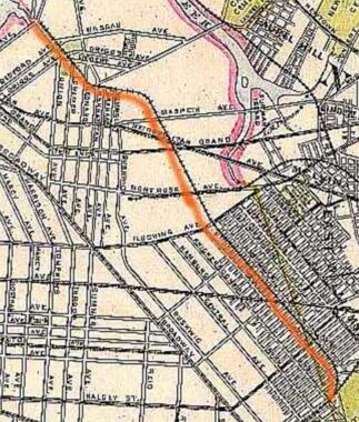
The 1873 Beers Atlas map at left shows the Evergreen in its heyday. In this era it actually served as a passenger line for several years and at its greatest extent, it ran from the waterfront in Greenpoint and extended through Bushwick and Ridgewood, skirting Evergreens Cemetery, until it connected with what is now the Bay Ridge Branch. In its salad days, the line saw steam locomotives.
Sometime in the early years of the 20th century, the old line was cut back to a junction with the still fairly busy Bushwick Branch near Flushing Avenue. From there, the Evergreen ran in a cut between Wyckoff and Irving Avenues to its eventaul merge with the Bay Ridge Branch at Cooper Avenue. For most of its life the line was used for localized freight deliveries to the various businesses that dotted its route. Gradually, those businesses disappeared, and the need for the railroad branch died too.
By the time I arrived at the site in the late 1990s and early 2000s, tracks could still be seen cutting across several side streets and I even found a crossbuck railroad stop sign on Hancock Street, cautioning drivers about trains that had stopped running for at least a couple of decades.
Seen above is the only visible remnant at a lot on Varick and Flushing Avenues. The Evergreen had a small trainyard there and several tracks served for train lauyps.
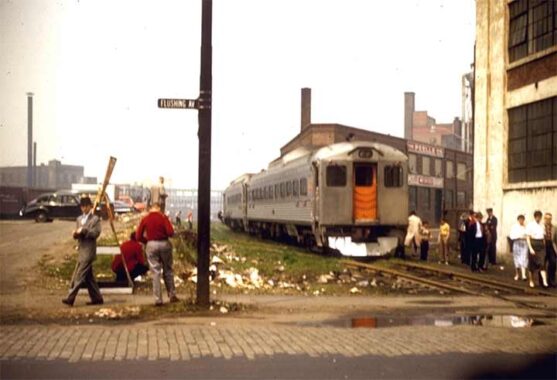
Art Huneke, who is now in his 90s, has a page dedicated in his indispensable LIRR site to the Evergreen Branch here. This photo of a passenger fantrip on the branch at Flushing and Varick Avenues was taken in 1957. Remnants of this track can still be seen.
Check out the ForgottenBook, take a look at the gift shop. As always, “comment…as you see fit.” I earn a small payment when you click on any ad on the site.
3/23/26
5 comments
looks like Pop’s Fixit Shop
If you go to the area around Varick and Johnson Ave. on Google Maps, then back out a bit, you can see a diagonally situated backlot that runs northwest to southeast for a few blocks, crossing Flushing Ave. and eventually terminating at Jefferson Street. A little squinting and some imagination could transform this backlot into the Evergreen Branch right-of-way…
Johnny,
Taking your advice, I bopped around on Street View, and just “up the road” at the intersection of Varick & Randolph, a Sept. 2024 shot still clearly shows track remnants embedded in the pavement. Bravo.
My exposure to this piece of track was the section from the Myrtle Avenue El station towards Cooper Avenue. In the early 60s, I recall seeing (from the El station) freight cars unloading at the (I think it was) lumber company that is now Food Bazaar. Memorable was the part that went across Weirfield Street – where the Weirfield Coal Company ( https://maps.app.goo.gl/ZpmW4U89ss46PZma6 ) still is. The street view has a “see more dates” option which you can go back in time to see older versions of their sign. They had coal silos, smaller and fewer than what the P.Dietz Coal Comoany had.
Btw, when you look at that Google map, and zoom in and follow it from the Weirfield Coal Company to Cooper Avenue, you will some more of those oddly shaped lots and “streets” / driveways/