

In May 2026, before the humidity set in for good, I took LIRR, subway, boat and Staten Island Railway to Pleasant Plains, a neighborhood in Staten Island I had probably not been in for a decade…during that time there was a pandemic, I had a hernia and back issues (still with the latter) but I’m “playing through the pain” especially mornings, and I’m catching up on areas I haven’t visited in a long while (cf. my Travis visit in August). I walked east on Amboy Road, touching on Pleasant Plains, Prince’s Bay and Huguenot; I had previously traversed Amboy Road west to Huguenot in January 2020, so gradually I’m seeing one of Staten Island’s lengthiest roads, which remains a narrow two-lane for much of its span from New Dorp to Tottenville. Pleasant Plains, which numbers 5000 residences, was given its name by the builders of what is now called the Staten Island Railway in 1860. The area is generally flat, with a couple of hills that will surprise you. This area is poorly documented, so it’ll be a photo-heavy essay, splitting into two parts with about 140 photos.
GOOGLE MAP: PLEASANT PLAINS – AMBOY ROAD
Before beginning, I should say something about what should be a very good boat to rail connection, but isn’t. In 2026 the Staten Island Railway is undergoing repairs, fitting for a 130+-year-old line. But they have not coordinated with the ferry. On weekends, SIR runs every 40-45 minutes on weekends, with trains leaving St. George just before the ferry arrives. That means I had about a 45 minute wait to get the train to Pleasant Plains. This scheduling isn’t a fluke either, as it was also in force on another Staten Island visit later in the year. Despite my hopes for increased Staten Island coverage, it has curtailed my Staten Island visits this summer on weekends.


Kicking things off with a look at the Pleasant Plains platform, which looks much the same as it did after a 1980s renovation. Something that’s really a “hallmark” of SIR stations, and before that Staten Island Rapid Transit… are really steep concrete steps. If you’re not careful, you’ll stumble and skin your knee through your pants or worse; fortunately I avoided that fate. Note the spanking new R-211 “subway” car; these have begin to populate the line, taking over from 1970s-era R44 cars. Had I ridden the line before the R-44s, I would have taken BMT Standard-esque* cars going back to 1925! After they were retired and before many of the R-44s arrived in 1973, the then-SIRT deployed some cars from the Long Island Rail Road! In 1964, this station looked rural indeed.
*See Comment by RR historian Andy Sparberg below
The “countdown clock” attests that if you just missed the train, you have a 41-minute wait. Grab a bench and bring some reading material. The L-shaped platform lamps are found on the SIR and nowhere else in NYC transit.
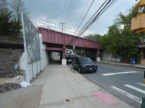
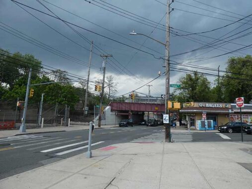
The Pleasant Plains station is bridged over Amboy Road; it likely ran at grade at one time, but I failed to notice or see the date of construction stamped in the concrete beneath the overpass, which was traditional in the early 20th Century and can be seen on many SIR and LIRR stations.


The small building with the slanted edge on the NE corner of Amboy Road and Penton Street is now a bagel shop. It served as Pleasant Plains’ post office in 1940 and underwent a period of abandonment in the 1980s. The closest brick and mortar post office is currently on 3031 Veterans Rd West, a couple of miles away, near the Bricktown Mall.


A couple from the west side of Amboy Road south of the RR overpass. (The east side is dominated by Amboy Plaza, a vast shopping mall.) the dwelling looks much the same as it did in its 1940 tax photo. Meanwhile, the Scarpaci Funeral Home arrived in Pleasant Plains in 2008, but it’s a branch of the much older Brooklyn location founded in 1910 in Bensonhurst.


Pleasant Plains is a small, Staten Island South Shore town, with the necessities (pizza place, barber shop, hardware) scattered along Amboy Road south of Pleasant Plains Avenue. There is the traditional dance academy (dancing schools are often found along railroad stations in Queens and Staten Island). The nearby Bricktown Mall hasn’t forced them into extinction as homeowners can walk to them instead of using gasoline.
Pleasant Plains Avenue
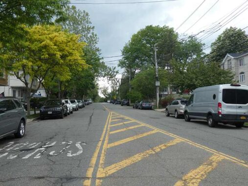


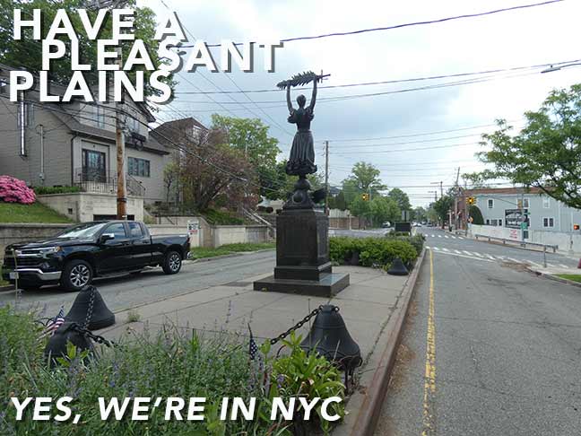
North of the tracks, Amboy Road reaches a major intersection. It turns east, with Bloomingdale Road going north and Pleasant Plains Avenue heading west. As we’ll see, a large monument is found here and the avenue is quite wide compared to other roads in the area. The reason for that is that it used to be the way to get to Perth Amboy, NJ and the mainland USA via the Outerbridge Crossing, constructed in 1928. However, since Drumgoole Boulevard was expanded into parkway status as Korean War Veterans Parkway, and the West Shore Parkway was built, both in the 1970s, Pleasant Plains Avenue goes only as far as a service road. Compare the Hagstrom 1949 and Open Street Map 2026 for the difference.
The Lady of Pleasant Plains
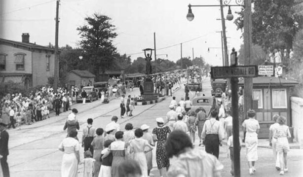
It’s Memorial Day sometime in the late 1930s and crowds are clustering the junction of Amboy and Bloomingdale Roads for a ceremony at the Pleasant Plains World War I monument, dedicated in 1923 and sculpted by Tottenville resident George Thomas Brewster. As we’ll see, however, the statue that stands at the junction today is an exact replica and not the one you see in the picture.
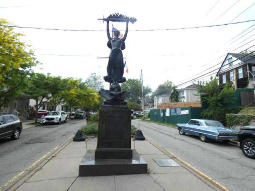
As impressive as it is, this monument has perpetually stymied whatever camera I have been using. The best time to approach it is in the morning, while the sun is striking it, and living in Queens, I can never get there that early. Otherwise, it’s mostly in shadow. A better photo can be seen at SILive. “Lady Victory wears a breastplate fastened above her flowing skirt. Standing on a pedestal along with a spread-winged eagle, she thrusts a sword wrapped in a palm leaf above her head.” Yes, that is a vintage 1960s Chevy on the right.


Additional views. An interesting touch is the depiction of of a WWI soldier’s helmet on the back of the eagle.


All 493 combatants from Staten Island’s former 5th Ward (Pleasant Plains, Prince’s Bay, Richmond Valley, Rossville and Tottenville) names are inscribed on three tablets at the statue’s base. The 4th lists the 13 who lost their lives.
This memorial is actually a replica of the original, since after 1970, after one car crash too many, she was removed to storage and was hidden too well, since no one knows what happened to it. Working from photographs, sculptor Glenn Hines, working with the fabricated by Modern Art Foundry of Queens), recreated it in 1996 and it was dedicated the following year, this time in a more substantial raised traffic island. So far, so good. Jamaica’s Queens Civil War Soldiers and Sailors Monument was also situated dead central in the middle of the busy Hillside Avenue and Merrick Boulevard intersection until it was moved to nearby Major Mark Park, where it stands mostly, er, forgotten.
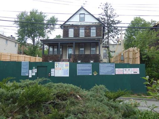
The Green Fence of Doom has appeared around this Pleasant Plains Avenue dwelling, and you know what that means. It appears in its 1940 tax photo in a nearly identical appearance. Sick transit, Gloria!
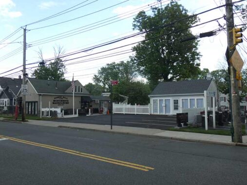
Joseph Hall Monuments has been in business since 1948 and is currently on the corner of Amboy Rd. and Sharrott Avenue (the latter named for a prominent South Shore family; there’s also a Sharrott Road). It’s an odd location for a monument dealer, as the closest active major cemetery is a couple miles west on Amboy Rd. in Tottenville, Bethel Cemetery.
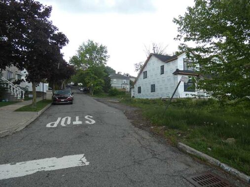
Idaho Avenue issues north from Amboy Rd. and then bends west to meet Bloomingdale Road. If you check the 1949 Hagstrom, Idaho Avenue was originally a dead end on Bloomingdale; this section was added later, but it still presents a small-town rural appearance with no sidewalk and an unbuilt-on lot at Amboy. Why is there an Idaho Avenue in Staten Island?
A quick heavy shower arrived which had me under a tree for ten minutes, but the sun came out strongly after that.


A sampler of the well-kept houses and lawns of Amboy Road at Idaho and Goff Avenues.


In what’s something of a theme for this page there is very little online documentation for St. Mark’s United Methodist Church, #6144 Amboy Rd. opposite Peterson’s Lane. I am aware it was built around 1875 and looks much the same as it did in its 1940 tax photo.
Petersons Lane


When I first encountered Petersons Lane, opposite the church, in 1998, it presented a double whammy: a rural, country lane atmosphere, and the preservation of an ancient 1963-vintage yellow street sign.
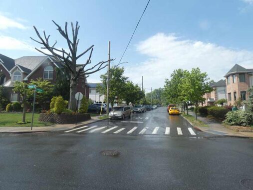
Today, Petersons Lane is fully built out with new housing and sidewalks (except for a short section at its northern end on Vogel Place).
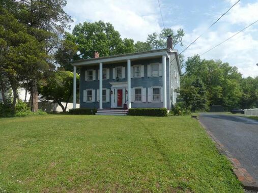
#6138 Amboy, with a very large front yard, sits opposite Peterson’s Lane. It is a “4-bedroom, 2-bathroom detached single-family home … listed with a pending status at an asking price of $999,000.”May as well make it a million…
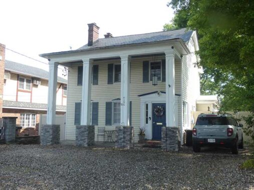
Next door we find #6136 Amboy. Its spring eave and massive 4 columns remind me of a pair of historic homes further north in Stapleton at #364 and #390 Van Duzer Street, both built in the 1830s. Could this house be similar in age?


The combined parishes of St. Thomas the Apostle and St. John Neumann worship in this relatively new church at #6097 Amboy Road. the original church as a bit further east at Amboy Rd. and Woodvale Avenue and was destroyed by a fire in the 1980s. Yet, looking at the tax photo, the original church had a stone exterior, so that must have been some fire.
The expression “doubting Thomas” comes from St. Thomas the Apostle, who doubted Jesus’s resurrection (in the Gospel of John) until he saw and touched His physical wounds. According to tradition he expanded Church teachings to India, where he was martyred. Bishop Neumann (1811-1860) founded the first Catholic diocesan school system in the USA and the first and only, so far, American male citizen to be canonized as a saint; presumably, the current Pope Leo will make it two, though we hope he has a lengthy papacy.
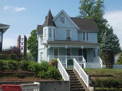
The parish center is next door, with its prominent peaked turret. Parish priests get good cardio ascending the steps, as church and rectory are built on a hill.


East of busy Maguire Avenue, Amboy Road is bridged over Lemon Creek, a trickle of a waterway that empties into Raritan Bay fter originating in Rossville. Staten Island’s south shore, except for centers such as Pleasant Plains and Tottenville, although rapidly developing right now, were mostly woods and creeks until the late 1970s. FNY took a look at Lemon Creek way back in 1999.


Another sampler of fine homes along Amboy Road, this time between the Lemon Creek Bluebelt and Bayview Avenue. Recognized neither by the Landmarks Preservation Commission nor Historic Districts Council, none have really been chronicled. But some nearby homes have.


Namely, the John H. and Elizabeth J. Elsworth House at #90 Bayview Avenue. Though it doesn’t show up on the map I created showing my route (linked at the top of the page) I detoured south on Bayview Avenue as it has a reputation for fine houses, and this house, designated by the Landmarks Preservation Commission, doesn’t disappoint.
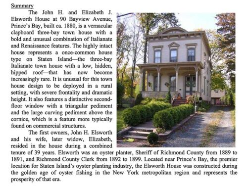
I’ll show its LPC summary here. Read the entire link, which gives a comprehensive history of Prince’s Bay, which I crossed into.


Meanwhile, here’s a selection of other worthy dwellings on Bayview Avenue that remain undocumented, at least in readily available sources.
Coming soon: back on Amboy Road into Huguenot
Check out the ForgottenBook (HarperCollins, 2006), as well as Forgotten Queens (Arcadia, 2013). I also have a chapter in the anthology “New York Calling: From Blackout to Bloomberg” (Reaktion, 2007). As always, “comment…as you see fit.” I earn a small payment when you click on any ad on the site.
9/12/26
5 comments
Great posting, as usual. Just two minor corrections are in order. I have taken the liberty of including more relevant information.
1. The Staten Island Rapid Transit cars used prior to 1973’s R44 cars were not BMT Standards. They were unique to the SIRT, which until 1971 was a subsidiary of the Baltimore and Ohio (B&O) Railroad. They were ME-1 cars, and the fleet consisted of 90 motor cars numbered 300-389 built in 1925; and 10 trailer cars numbered 500-509 built in 1926. They were the same exterior dimensions as BMT Standard cars, 67 feet long. That decision was deliberate, in order to use a never-built connection between the SIRT and BMT through a tunnel under the Narrows, that was started and abandoned in the 1920s. As envisioned, trains would operate between Staten Island and Manhattan using the BMT 4th Avenue Subway tunnel.
Source: https://nycsubway.org/wiki/SIRT_Staten_Island_Rapid_Transit
2. The Outerbridge Crossing was opened in 1928, not 1948. It and the companion Goethals Bridge to the north were opened on the same day in 1928 and were the first interstate vehicular crossings constructed by the then-fledgling Port of New York Authority, now known as the Port Authority of New York and New Jersey. The Goethals Bridge original span was replaced with a new one about ten years ago.
The PANYNJ is a multi-modal transportation agency, whose domain includes the PATH rail system, two bus terminals, the three major airports, and four additional vehicular crossings – the Bayonne and George Washington Bridges, plus the Holland and Lincoln Tunnels. Finally, it also owns the World Trade Center, subject of much news this week.
I meant to type 1928.
ok thank you – I’ve had my share of typos as well!
In re: “Green fence of doom/ You know what that means”: Actually I don’t know what it means. Please explain it.
Means it’s going bye bye