
Every couple of weeks I grab the camera and walk for a few miles; I wish it was more than that, but I’d have to be underemployed again. In late May, I decided to go from Maspeth to Woodhaven, which is a distance between 7 and 8 miles. Maspeth by now is well-trodden territory for me but the added twist was that I had never walked through Forest Park, the divider between northwest and southwest Queens, between Glendale and Woodhaven (I have biked Forest Park plenty of times). The two areas have seemingly little to do with each other, divided by the huge park, but as you know I’m all about bringing people together (oof) and besides, with a temp desk job in Hoboken during the week that has me sitting much of the time, I needed to move a bit.
GOOGLE MAP: MASPETH TO WOODHAVEN
Maspeth, in a western corner of Queens east of Greenpoint and Williamsburg, Brooklyn and west of Middle Village, seems stuck between the grit of Brooklyn and the airy, almost suburban atmosphere enveloping its eastern and southern neighbors, Middle Village and Glendale. Maspeth was first settled by Native Americans centuries before Dutch and English colonists arrived in the mid-1600s. It was absorbed by a newer settlement to the east (named, appropriately, Newtown–the present-day Elmhurst), became a part of the borough of Queens, and then became a part of New York City in 1898.
“Maspeth” is derived from Delaware Indian terms that have, by different accounts, meant “great brook” or “bad water place”; the latter seems rather appropriate, since Newtown Creek, noxious and noisome through most of its latter-day history, is nearby.
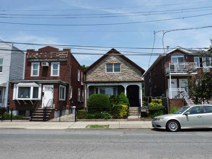
Jay Avenue houses. Not being a driver I’m forced into mass transit everywhere and because of a parade (more on that later) the Q18 bus was ending its route at Jay Avenue and 69th Street — so I headed down Jay, one of a number of Maspeth streets that were never assigned numbers during the 1920s when most other Queens streets were. In Maspeth it’s joined by Clinton, Hull, and Perry Avenues, Hamilton and Remsen Places and of course, Grand Avenue, an eastern continuation of Williamsburg’s Grand Street.
I was happy to see this oddly angled house at Jay Avenue and 66th Street still standing. When I last saw it, it had a “for sale” sign on it and I thought it was a goner. Whoever bought it kept it, but put in an addition with a slanted mansard roof, which you can see on the right.
Why was I happy to see the house? Way back in the late 1980s or perhaps the early 1990s I was living in Bay Ridge and, while I was content, was perhaps looking for a change of scenery. I thought of Maspeth, which demographically resembled the Bay Ridge of the 1980s, and saw a listing for an apartment which turned out to be in this building. The apartment was too small for my needs and I remained in Bay Ridge till March 1993 when I moved to Flushing; I had been working in Port Washington since July 1992 and the three-train commute was killing me. (In Maspeth the commute would still have killed me in the 1980s because it was still a two-fare zone.)
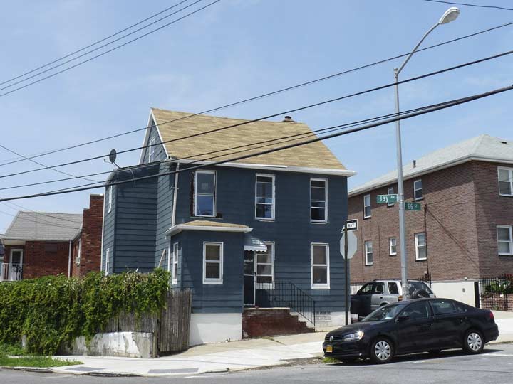
This blue-shingled charmer stands across the street on 66th Street.
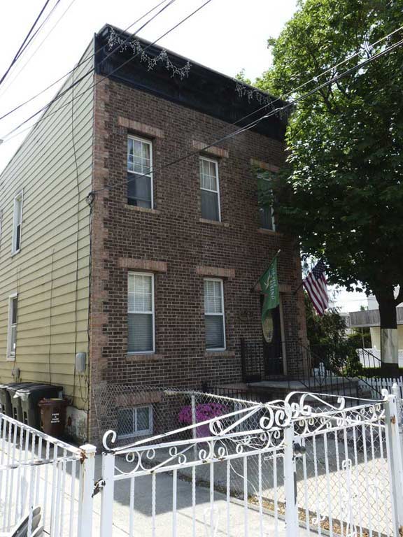
Brick buildings without a coating of siding in Maspeth are relatively rare; they are actually more plentiful in Ridgewood and Glendale. This one on Jay Avenue between 65th Place and 66th is an exception to the rule.
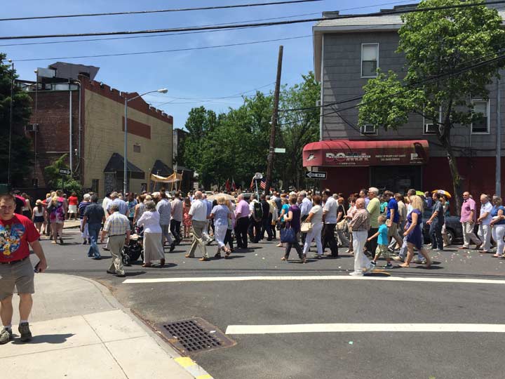
Crossing the Queens Midtown Expressway at Hamilton Place, I found the religious parade that had detoured the bus. Noticing a lot of Polish being spoken, I assumed the parade must have something to do with nearby St. Stanislaus Church (see below). St. Stan’s is one of two Catholic churches in close proximity in Maspeth; the other is behind me as I shot the photo, the Church of the Transfiguration, one of the truly beautiful buildings in Queens; FNY correspondent Christina Wilkinson was married in the church. I discussed the church building on this Brownstoner Queens page and led a Newtown Historical Society tour past it in 2011. Those links discuss some Maspeth highlights I won’t be able to get to on this page. [If you can identify the feast, which took place in late May, email kevinjudewalsh@gmail.com]
Note the plain building on the left with the buff and brick exterior, the Polish-American National Hall, formerly the Polish National Home.
As early as 1890, Polish immigrants chose Maspeth in which to settle. In 1921, the Polish National Home (or in Polish, “Polski Dom Narodowy”) was founded in order to teach younger generations about their Polish heritage. This building was erected in 1934. Members of this organization opened the 1939 World’s Fair, dedicated Maurice Park and participated in the opening of the Kosciuszko Bridge the same year. Maspeth has welcomed a new wave of Polish immigrants over the last couple of decades.


A look west on 56th Avenue between 61st and 64th Street (Queens street numbering skips numbers now and then but overloads with the same number in some spots, such as a nearby area where every street is numbered 60). Note the simple two story porched house. If you look carefully you can see the towers of the New Kosciuszko Bridge going up. It will be a twin span cable-stayed bridge and is expected to open between 2018 and 2020. In winter the view will be very good from here.


Here’s a pair of dueling Polish delis on 61st Street and 56th Road and 56th Drive, respectively. Syrena is named for the “mermaid of Warsaw,” who has appeared on the Polish city’s coat of arms since the 1390s in altered forms over the centuries.
There are various legends about the Warsaw mermaid. The main one used in the City’s literature and by tour guides says that the mermaid was swimming in the river when she stopped on a riverbank near the Old Town to rest. Liking it, she decided to stay. Local fishermen noticed that something was creating waves, tangling nets, and releasing their fish. They planned to trap the offender, but fell in love with her upon hearing her singing. Later, a rich merchant trapped the mermaid and imprisoned her. Hearing her cries, the fishermen rescued her, and ever since, the mermaid, armed with a sword and a shield, has been ready to help protect the city and its residents. wikipedia
Krakus, meanwhile, is a Latinified form of the other great Polish city, Kraków.
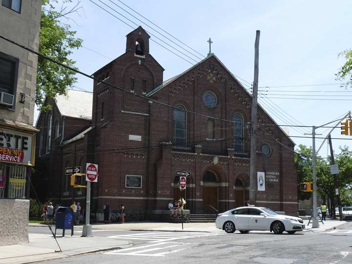
St. Stanislaus Kostka Church, 61st Street and Maspeth Avenue. The parish was established in 1872: at that time the nearest Catholic church was St. Mary’s in Woodside (actually a smaller subneighborhood called Winfield). The present brickfaced church was built in 1923. There is also a St. Stan’s in Greenpoint on Driggs Avenue & Humboldt Street; former Polish president Lech Walesa and the late Pope John Paul II have each visited that church.
Stanislaus Kostka (1550-1568) was a Polish Jesuit novice who walked from Vienna to Rome, likely contracting malaria on the journey, from which he died at age 17. He was canonized in 1726.


The brick rectory, or priests’ residence, on 61st Street, is as spectacular as the church (I have a fondness for brickface architecture). Then there’s the name chiseled in concrete in serifed lettering — especially the “LA” near-ligature.


PJ’s Newsstand, with a painted ad dating back a few decades, used to be on the corner of 57th Drive and 61st Street; however, traffic has been redirected onto Grand Avenue and a pedestrian plaza and a flowerbed now occupy the corner.
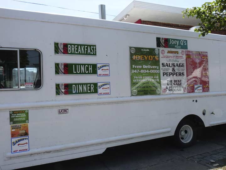
Why did I notice this food truck parked on 57th Drive? Because it has expert renditions of New York City street signs affixed on it, some using Highway Gothic, some using Clearview. I couldn’t have copied the signs better myself using Photoshop!
The Italians of Maspeth assert themselves on 61st Street, as I passed Three Brothers Pizzeria and the Russo and the Osteria Italiana bakeries between Grand and Flushing Avenues.


The corner of Flushing Avenue and 61st Street has not been paved in recent years, which has allowed some of the roadway’s old trolley tracks to reappear. These tracks were used by the #58 trolley between Ridgewood Terminal and Flushing and ended service July 17, 1949. The Q58 bus, a ponderous route which seemingly hits every red light in Queens when I use it (consequently I have caught up on sleep while aboard) nearly duplicates the old trolley route today.
Old maps indicate that the stretch of 61st Street between Flushing Avenue and 59th Road is actually the former northern end of Fresh Pond Road, and that Cypress Hills Street, seen later on in this series, is actually the original southern end.


Forgive me for a frequent indulgence but I can’t help but mention that 61st Street has a few light posts that still have General Electric sodium vapor fixtures from the 1970s or 1980s. In NYC the vast majority of these were replaced with new “sodes” in 2009. I’m afraid these two haven’t got much life left, as the light emitting diode revolution is coming to NYC and they’ll soon be replaced.
The shiny cylindrical lamppost is nonstandard itself. These are manufactured by a firm called Flagpoles (which I can’t find on the internet or don’t have the time). They’re mainly used on expressways or parkways but now and then, one makes its way to a local route.

As you are driving on 61st Street south of Flushing Avenue 61st Street makes a curve to the left and a caution Cyclops blinking light has been installed on one of the Donald Deskey lampposts first installed with frequency on NYC streets in 1962-1963.
I now embarked on a walk of about one mile south on Fresh Pond Road, a commercial spine bridging Maspeth and Ridgewood. Before the neighborhoods were built up in the mid to late 1800s, there were indeed a number of fresh (as opposed to brackish or saltwater) ponds scattered about in the area. Along with names like Juniper Valley Road and Dry Harbor Roads in Glendale, I’m glad the old name for the route has been retained.
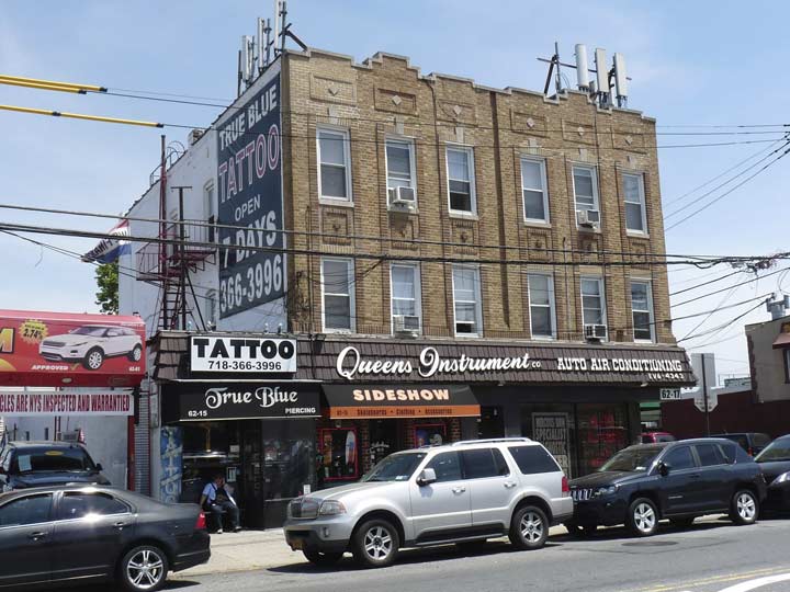
What I call the Queens Instrument Building stands just north of the intersection of Fresh Pond Road and Metropolitan Avenue. I will begin some disputes with this, but I consider the intersection the dividing line between Maspeth (north of Met Ave.) Ridgewood (south of Met Ave.) and Middle Village (east of Fresh Pond Road). Some say, though, that Middle Village begins east of the cemeteries on 69th Street.
Until I revamp my WordPress template and regain a Comments section, fire away at kevinjudewalsh@gmail.com.


I’ll put two of my favorite eateries in the general area together here. There are actually two Rosa’s Pizzerias in these parts, one (actually Rosa not Rosa’s) on 69th Street and Clinton in Maspeth and this one, on Fresh Pond Road south of Metropolitan, technically in Ridgewood. This Rosa’s is my personal favorite, but there are dozens of pizzerias to choose from here. (Coming in a close second is Joey’s at 69th and Grand, featuring sesame seed crusts.) Zum Stammtisch, Myrtle west of Cooper, is one of the last of the old line German restaurants in Glendale; in recent years it opened a branded pork store next door. I always get the chicken schnitzel.


Walking south on Fresh Pond Road, a Polish atmosphere remains palpable.
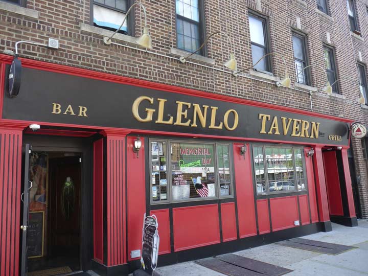
Neither should an Irish influence in Ridgewood be ignored. This tavern is named for a centuries-old abbey in County Galway that has found new business as a hotel.
Desiring a unique identity for their area in the late 1800s, residents adopted the name of the Ridgewood Reservoir, constructed in 1856 on the Kings-Queens County border, for their town. When map printers applied the name ‘Ridgewood’ to an area larger than that of the town limits, the tight-knit community changed its name to ‘Evergreen,’ after the large nearby Cemetery of the Evergreens. In 1910, the name Ridgewood was officially bestowed upon the entire area nestled between Glendale and Bushwick. However, traces of the old Evergreen name still exist today.
The Evergreen Branch of the LIRR once passed through the area, and remains of it can still be found in Ridgewood if you look carefully; traces get harder to find by the year, however.
–from FNY’s Ridgewood neighborhood page


One of the beasts at the Animal Clinic of Queens, Fresh Pond near Gates, reminds me of Nipper, the RCA Victor terrier who listens for his master’s voice on the grammophone. (Look it up, millennials.) In fact it reminded me of Albany, New York because a giant version of him has sat on a warehouse on Broadway in that city since the late 1950s and our family would see him when we drove past the building during upstate visits. The building is being condo-ized but It’s said that Nipper will remain.


Brick front buildings rule in Ridgewood. Many were constructed in yellow or buff bricks by Gustave X. Mathews in the early 20th Century in vast swathes of the neighborhood.
From the FNY Ridgewood page: Mathews mass-produced these multi-unit houses for about $8,000 and sold them for $11,000. They did not have central heating or hot water systems. The only heat came from coal in the stove and a kerosene heater in the living room. Despite this, the U.S. Government gave special recognition to Matthews’ concept in 1915 when an exhibit was opened at the Panama-Pacific Exposition in San Francisco. It showed the world how efficiently these type of apartments met housing needs for a surging population.


Other groupings of attached brick buildings, like these on Palmetto Street, were constructed by builders Paul Stier, Henry Mayer and Walter F. Ring.
Impressionable tyke I was, when I was poring over NYC maps as a kid when the other kids were out playing stickball, “Palmetto Street” reminded me of “Walnettos,” the chewy candy made (in)famous on the Laugh-In TV show.
ForgottenFan George Miller: In 1850-51 Watson Bowron had surveys and a subdivision map prepared for property including several new roadways in the territory of the Town of Bushwick adjacent to the old Brooklyn city line. This subdivision was known as Bowronville. All of these roadways running somewhat in a southwest to northeast line beginning at Division Ave. (now Broadway) and running to current Evergreen Ave. (part of the old Bushwick Lane) were named by him for trees and vines. The roadways were Linden St., Magnolia St. (now Gates Ave.), Palmetto St., Woodbine St., and Ivy St. (now Madison St.). These names did not duplicate the official names of any existing streets in Bushwick, Williamsburg or mid-19th century Brooklyn. When these roadways were eventually extended to and beyond the Queens County line, the Town of Newtown in Queens adopted the Brooklyn names for the continuation of these roadways in the Queens territory.


Is there anything more American than grocery stores brimming with fresh produce, with goods shortages a problem for much of the world? I don’t say “God Bless America” at sports venues. I say it at supermarkets.


The Polish influence remains strong on the south end of Fresh Pond Road. The Kefirek Deli at Putnam Avenue has a representation of the white eagle of Poland’s coat of arms:
According to legend, the White Eagle emblem originated when Poland’s legendary founder Lech saw a white eagle’s nest. When he looked at the bird, a ray of sunshine from the red setting sun fell on its wings, so they appeared tipped with gold, the rest of the eagle was pure white. He was delighted and decided to settle there and placed the eagle on his emblem. He also named the place Gniezdno (currently Gniezno) from the Polish word gniazdo (“nest”). wikipedia
Walking south of the elevated M train Fresh Pond Road station, here’s a former Child’s restaurant at 67th Avenue, marked by a heavy use of terra cotta ornamentation. This one doesn’t have the usual Child’s fish or seafood theme, but other remaining ones around town still do.


A different variety of brick mixed-use building from the buff Mathews buildings shows up on Fresh Pond Road south of the el.
I’m ready to head into Glendale but I need to stop for a drink first where Fresh Pond Road meets Cypress Hills Street.
8/7/16