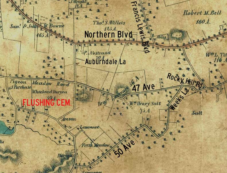
One again, it’s time to go back…way back..back into time with my western Queens map published in 1852. This is the earliest map of the area in my possession. It’s a shame that no photos seem to exist of this distant era, when today’s cosmopolitan borough was still mostly farms, meadows and plains, dotted with small towns like Flushing and Jamaica connected by wagon trails and farm to market roads.
Yet the basics of the present street layout were in place, a half century before the prevailing street grid was built. Some of these trails have evolved into major vehicular roads because they remained convenient. They skirted bodies of water and got around high hills, which made driving animals or powering nonmotorized vehicles easier.
Let’s take a look at 1852 and see how much remains today.
At the top of the map is the still unnamed Northern Boulevard, a route that has been in existence as a Native American trail and then a colonial highway. Soon it would be called Broadway (giving its name to a Long Island RR station at 162nd Street) but by 1920, it was called Northern Boulevard.
This map predates Flushing Cemetery by one year, as the burial ground was founded in 1853. Yet, the ring of roads that surrounds it was already in place. Pigeon Meadows Road, the only street name on this section still used today, is now 46th Avenue but its name was re-applied to the road on the south side of the cemetery.
That same 46th Avenue was once part of a very old road that came to be called Rocky Hill Road; it traversed glacial hills in its southern sections. That lengthy road still exists today and comprised parts of 46th, 47th and 48th Avenues, Bell Boulevard, Springfield Boulevard and Braddock Avenue. However, only a short section in between 47th Avenue and 48th Avenue at the Clearview Expressway bears its name today.
Fresh Meadow Lane, in the colonial era, was a meandering north-south road that was the precursor of the straighter Utopia Parkway, though a substantial two-mile section has been allowed to remain. Its northern leg, between the cemetery and the LIRR, is now called Auburndale Lane.
50th Avenue is unnamed on the 1852 map, but it was later named for the prominent Lawrence family, which still is remembered by a cemetery on 42nd Avenue and 216th Street in Bayside. If you look at the top of the map you will see property in the hands of the Willets and Bell families, for which various Queens locations are still named today.
Weeks Lane is just a trickle on the map. It was once a lane leading to the Weeks farm. I go into detail about this surviving lane on this FNY page.
Francis Lewis Boulevard, once known as Cross Island Parkway until it was named for a signer of the Declaration of Independence from Flushing, only made it as far south as Northern Boulevard in 1852. By the 1930s, through a series of extensions, it would run all the way to the Queens-Nassau line in Rosedale!
Check out the ForgottenBook, take a look at the gift shop, and as always, “comment…as you see fit.”
11/2/17

