
Back in March 2000 I set out with a band of urban explorers that walked the old LIRR Rockaway Branch from Rego Park to Woodhaven. The group included the late photographer and urban chronicler Bernard Ente and the MTA’s Mark Wolodarsky. I recently rescanned the pictures I took that day, and will insert them in appropriate spots in this post.
GOOGLE MAP: ROCKAWAY LIRR BRANCH
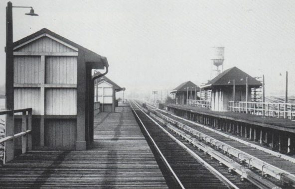

There were two station stops along the Rockaway Branch between the main line and Woodhaven. The first of these was Parkside, which was located between Alderton and Selfridge Streets north of Metropolitan Avenue. We’re still about a mile north of Forest Park, so the station was unusually named. Note the wood-planked station walkway and four sheds, two enclosed, two open. Station illumination consisted of simple incandescent bulbs. Parkside opened in 1927 and was in service until Rockaway Branch service ceased in 1962.
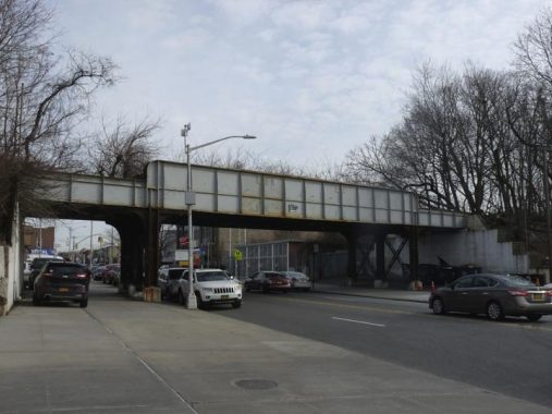
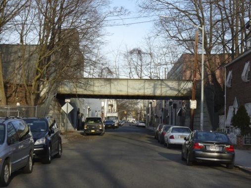
Looking east along Metropolitan Avenue at the Rockaway Branch overpass. The Parkside station was past the left side of the picture. Metropolitan Avenue was built as a toll road, the Williamsburg and Jamaica Turnpike, in the 1810s connecting the Kings County waterfront with the town of Jamaica, and after the toll was removed after the Civil War the road was renamed Metropolitan Avenue.
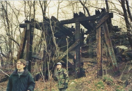
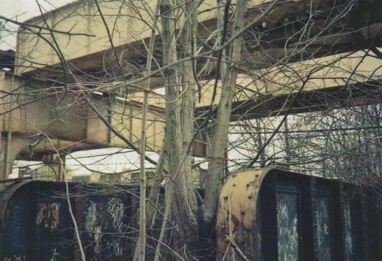
In 2000 our group had to carefully negotiate the Rockaway Branch’s crossing of another LIRR line, the Montauk tracks, which connect the LIC terminal at Hunters point with the Jamaica station along the main line. I’ve referred to the Monauk a great deal — it carried passenger traffic until the 2000s, and had several active stations until March 1998, by which time the stations were just clearings along the unelectrified tracks.
The Rockaway appeared to cross the Montauk on a wood trestle. I’m not sure if there was ever an active connection between the two lines. The Montauk is still used for freight and to move passenger cars, but there’s no passenger service these days, as all service from LIC is now routed through the Hunters Point Avenue station and the Sunnyside Yards.


I used Woodhaven Boulevard to cross the Montauk tracks, since I hadn’t in a while, and now I know why: with its endless laborious walkway ramps, it’s a pain in the neck (though the ramps are still largely lit by yellow sodium lamps which are quickly disappearing elsewhere). What I could have done was cross Woodhaven at Metropolitan, walked Met Ave. to 88th Street, turned left and crossed the tracks using 88th Street’s simple grade crossing, which is on this FNY page along with views of the Montauk tracks. Next time…


The Rockaway Branch is also trestled over Union Turnpike, which runs from Myrtle Avenue in Glendale east to New Hyde Park. Unlike Metropolitan Avenue the road was largely built in the early 20th Century and, despite its name, it was never a toll road. I don’t have any photos of our group crossing it in March 2000 — however, once we did get across, we were met with a surprise.


Pedestrians can use the Union Turnpike walkway to get across the Rockaway tracks. Looking south from the walkway, you see not the tracks, but a parking lot! When the massive Forest View Crescent condo complex was built as a regular apartment building in the late 1960s, the Rockaway Line, which went out of business in 1962, was paved over and the parking lot built in its place. Therefore, any plans to rebuild passenger train service or build a High Line-style park here would have to purchase the land from the condo board. I doubt anything like that will happen.
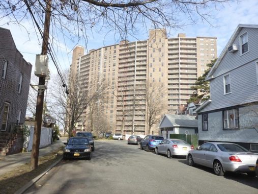


Forest View Crescent is a very large building and easily dominates views from the surrounding neighborhood. The building is seen from a small piece of Trotting Course Lane below Union Turnpike. The lane is a laftover piece of Woodhaven Boulevard from before the 1920s when the road was straightened and widened. The lane leads straight into Forest Park.
Forest Park is up there among NYC’s biggest parks, with over 500 acres stretching between the cemetery belt, Kew Gardens, Union Turnpike and Glendale and Park Lane South in Woodhaven and Richmond Hill. It forms a natural boundary between communities in northern Queens (Glendale and Forest Hills) and their southern cousins in Woodhaven and Richmond Hill.
Forest Park was actually created by the city of Brooklyn in 1895, with the city’s Parks Department buying up acres of forested, pretty much unused property, hence the name. It’s among the more ‘natural’ of our big parks, with about 165 acres left as woodland, interspersed with marked trails.
The park was surveyed by Frederick Law Olmsted, the co-developer of Central and Prospect Parks and much like the parks and natural reserves of Staten Island, Forest Park contains several nature trails ‘blazed’ or marked for the ease of hikers, and also boasts a bridle path.
The park was surveyed by Frederick Law Olmsted, the co-developer of Central and Prospect Parks and much like the parks and natural reserves of Staten Island, Forest Park contains several nature trails ‘blazed’ or marked for the ease of hikers, and also boasts a bridle path.
Rockaway Tracks
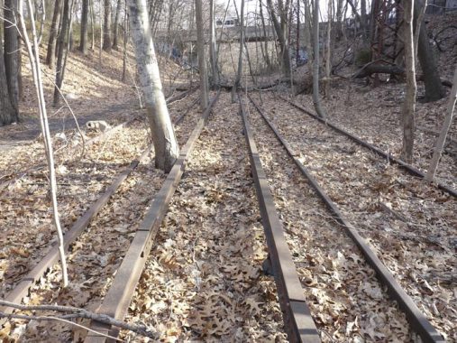


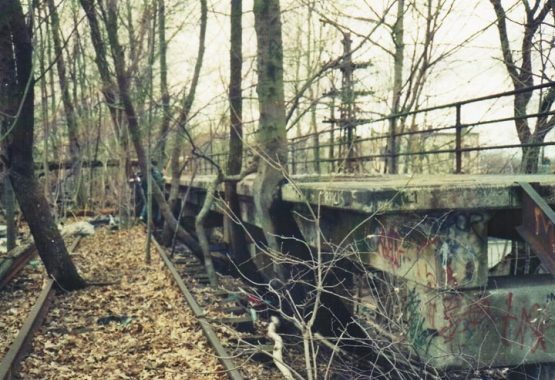
In an occurrence that still surprises me somewhat the old tracks of the Rockaway Branch are available for all to explore in an open section of Forest Park entered at Trotting Course Lane north of Margaret Place. The tracks are not part of the park trail system and anyone exploring them does so at their own risk. There hasn’t been active rail service since 1962 and the rails are not electrified, but the footing is not good and it would be an easy thing to trip and fall or twist an ankle on the uneven footing. Walk the tracks here with caution.


I made my way along the park paths to Forest Park Drive, which is also bridged over the tracks. The drive runs the width of the park, but is only open to auto traffic west of Woodhaven Boulevard. I went past Victory Field, named shortly after WWI to mark the Allied victory over Germany; Staten Island’s Victory Boulevard is named similarly.


Attaining Woodhaven Boulevard again, I quickly turned left on 98th Street, which curves south along the Rockaway Line right of way, entering Woodhaven. On old maps this section of 98th Street between Woodhaven Boulevard and Park Lane South is called Diamond Street.


Here, Park Lane South, which skirts the southern end of Forest Park, is crossed by the Rockaway Branch as it enters Woodhaven.
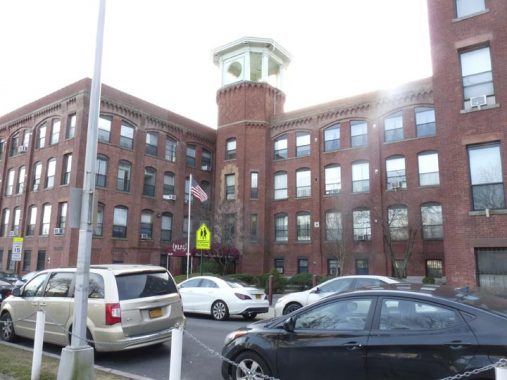


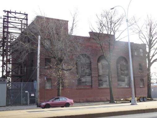
The former red brick tobacco pipe factory on Park Lane South and 101st Street, along the Rockaway Branch right of way, has intrigued me for the 26 years (as of 2019) I have lived in Queens and I always entertained moving in, but it’s a long way from the LIRR Port Washington Branch, which your auto-free webmaster has always used as a lifeline. So, about once or twice a year, I bike or walk by and look at it the way a cat looks through the glass at the fishmonger’s. How can I resist a complex that comes complete with a watchtower.
Here briar was turned and polished to manufacture Frank Medico smoking pipes. Built at a time when every man could afford a pipe and conversations centered on which shape burned coolest to the taste. The old factory was converted to condos in the 1990s. The adjacent Rockaway LIRR may have had a siding where goods could be loaded right from the factory.
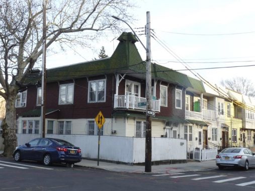
Woodhaven has some intriguing architecture, like this residence at the corner of 85th Road and 101st Street across from the DeMuth factory.


The venerable Romanesque PS 66, 85th Road and 102nd Street, is one of Queens’ most beautiful school buildings. It is one of three public schools built in the early 20th Century in a real estate development called Brooklyn Manor. Its bell tower called children to school when much of the surrounding neighborhood was made up of farmland. The school honors Jacqueline Kennedy Onassis, the widow of John F. Kennedy whose advocacy helped save Grand Central Terminal from the wreckers’ ball.


Woodhaven will surprise you with a lot of housing stock in close to its original condition. 101st Street runs on the east side of the Rockaway Line’s right of way, and many of its older houses will have ancient roofline and above window detailing.
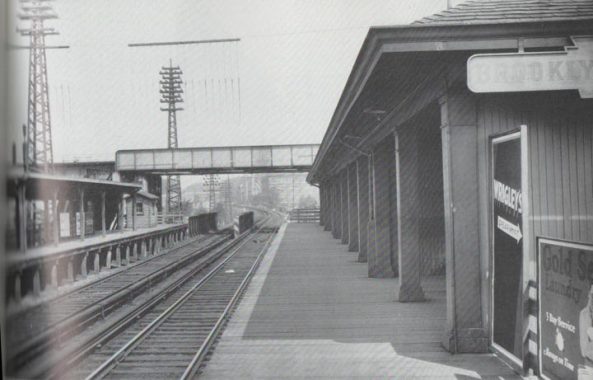

A second local station along the Rockaway Branch was at Brooklyn Manor, just north of Jamaica Avenue (you can see the elevated trestle just ahead). Pictured in 1931, the station opened in 1910 and closed when the line did, in 1962. Note the Wrigley’s Spearmint Gum ad on the right, as well as the keystone-style station sign. The Pennsylvania Railroad owned the LIRR from 1900 to about 1960 and keystone imagery played a role on elevated trestles, signs and even plates on the noses of locomotives.
I wish I had gotten more of a panoramic shot of the Rockaway Line passing under Jamaica Avenue. We did not find any traces of the Brooklyn Manor station, but that wasn’t true of the next station south, as you will see.

Hook & Ladder 143/Engine 294, Jamaica Avenue and 101st Street. Architectural information is usually sketchy regarding firehouses, but this one appears to be early 20th Century. Interesting paneling in the arches above the second floor windows.


Here the Jamaica Avenue el carrying the J train (and the Z during rush hour) crosses over the Rockaway Line. It’s not the only abandoned passenger LIRR line the el passes over—it also bridges the Montauk Branch at Lefferts Boulevard, a mile or so to the east.
Jamaica Avenue itself is an ancient road, evolving as the Jamaica Plank Road in the early 1800s, beginning at the confluence of Broadway, Fulton Street and Pennsylvania Avenue. It extended east into Suffolk County as Jericho Turnpike and today, as Route 25, extends to the east end of Long Island. The name “Jamaica” has nothing to do with the Caribbean but was originally a name the Lenape Indian tribe, original Queens inhabitants, gave themselves (Jameco). The two names evolved the same name and pronunciation separately.
Seen from 98th Street, the Rockaway Branch passes over 91st Avenue.
Woodhaven Station
In 2000 our group found the platforms of the Woodhaven station on the Rockaway line relatively intact. This station was the relative new kid on the block, having been built in 1942 just after the Brooklyn branch of the LIRR had been placed in a tunnel under Atlantic Avenue. The underground Woodhaven Junction station closed in 1976, 14 years after the above-ground Rockaway Line closed.

If you look closely you can see the trademark diamond pattern the LIRR used on its concrete station platforms. The Woodhaven station is a time capsule from 1962, the last year LIRR trains stopped here. Original station lighting mastarms are still in place…
…while one of the lamps has its original reflector dish.

This staircase, now blocked up on street level, led to an entrance/exit on Atlantic Avenue.


Woodhaven Station remains in place in 2019, unchanged in most aspects from when we encountered it in 2000.
The now-abandoned LIRR substation is present on the south side of Atlantic Avenue west of the elevated line.
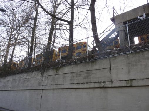
As we noted in 2000 a portion of the Rockaway Line has become school bus parking. The ramp is on the west side of the tracks; this is a view from 100th Street on the east side.

Here the Rockaway Branch is bridged across 97th Avenue.


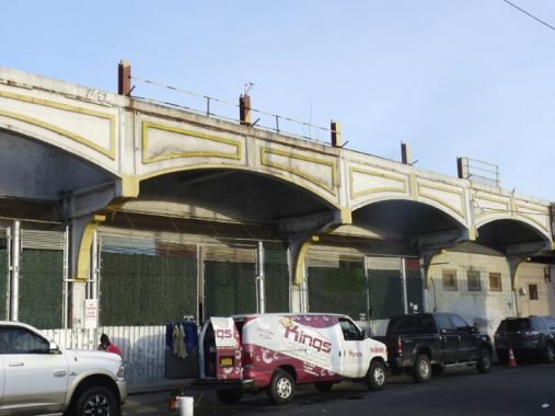
At 101st Avenue (the main commercial strip of Ozone Park) one of the remaining Rockaway Line signal towers can be seen; we are getting closer to the junction with the Liberty Avenue elevated, south of which the right-of-way is active again with A train service, which has used it since 1956.


These are the remains of the old Ozone Park LIRR station just south of 101st Avenue at 100th Street. This was once a very important transfer point on the LIRR. The present remains of the old Ozone Park station date to 1930, when the elevated concrete station replaced the grade-level tracks. Service ceased on this line on June 8, 1962.
Herbert George, whose book Change At Ozone Park describes the various LIRR lines that extended to the Rockaway Peninsula, describes the Ozone Park station:
Ozone Park station was set up to enable passengers from Pennsylvania Station and Flatbush Avenue to reach the Rockaway Park area or Far Rockaway section simply by changing trains (“Change At Ozone Park!”) At certain times, the trains would stack end-to-end, and passengers would transfer back and forth on the platform. Of course, operation in the reverse direction also occurred. Due to street restrictions below, which limited the right-of-way width above, platforms were on the outside of the four track right-of-way, making an across-the-platform exchange impossible. To accommodate this, the platforms were made exceptionally long, so that non-rush hour length MU trains could stack end-to-end and allow passengers to transfer. A set of crossovers from the outside tracks to the inner tracks were at the east end of the station, to permit trains stopping at Ozone Park to run express after the station stop, or to perform the reverse move.
Sources: Herbert George, Change At Ozone Park, © 1993 RAE Publishing


At Liberty Avenue, the A train elevated rises high over the LIRR Rockaway Branch. Here, A trains proceed east to Lefferts Boulevard or turn south along the Rockaway ROW, cross Jamaica Bay, and serve the communities of Broad Channel and Far Rockaway. A shuttle S train can be boarded at Broad Channel that proceeds to Rockaway Park. When service over Jamaica Bay is suspended, A train service sometimes runs east-west on the peninsula, connecting Rockaway Park and Far Rockaway.
Liberty Avenue is rumored to take its name that when first built, it was never tolled, hence was always “free” of charge. The avenue runs from Brownsville in Brooklyn east to St. Albans in Queens.
The elevated train here is actually the east end of the old Brooklyn Fulton Street El. It was cut back in the most part in the 1940s, with the IND Fulton Street subway connected to the el trackage at the east end in the 1950s. West of the 80th Street station, the el was torn down along Fulton Street and Pitkin Avenue by the mid-1940s.
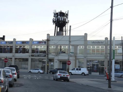
The Martian tripod stands ready to lay waste to Ozone Park! What’s that you say? It’s only a cell phone tower. It stands in front of a building decorated with the double-snaked staff of Asclepius and the phrase “Nemo Medicanical Science.” Nemo was an early 20th Century corset factory; these days the building is mixed-use.

The ubiquitous Injury Lawyers are ready to take acer of things if I wind up with a problem on the way home from the A train Rockaway Boulevard station, which proceeded without mishap.
Check out the ForgottenBook, take a look at the gift shop, and as always, “comment…as you see fit.”
6/2/19
21 comments
Notwithstanding Forest View Crescent condo complexe’s use of the right-of-way for parking, it is still a federally designated railroad and it is unlawful to build anything on it. That is why they have permission to park cars there but didn’t construct any buildings. I doubt if they even own it. They may have merely usurped the space or perhaps that have a lease from the city. Either way, restoration of rail use preempts their parking.
There is no longer any RR right-of-way. Also, as per the QueensWay page: “Portions of the this property are leased for various community uses including sections of the parking lot of the Forest View Crescent Apartment Complex, the Ridgewood-Glendale Little League fields, and the Forest Hill Youth Athletic Association fields.”
Leased is exactly right as the LIRR still owns the right of way whether it’s visible or not.
If service was ever restored leases would cease and that parking lot would be no more.
QueensWay is just that, a page with hopes. Like it or not the former route is still railroad property.
Hi, Kevin. Great article on material that I am familiar with. The ‘http://maps.nyc.gov/doitt/nycitymap’ 1951 aerial map clearly shows two spurs connecting the Rockaway and Montauk lines. The two abandoned Rockaway line trestles that still cross Union Turnpike at different angles are a clear remnant. The spurs were likely not used for revenue trains. Ask Arrt of Arrt’s Archives to be sure.
Forest View Crescent, to the best of my knowledge, isn’t a condominium. In the ’70’s I knew a couple; the husband was veteran & they were just starting their adult lives. Because of his veteran status he was eligible for Forest View which he described to me as sort of a Mitchell_Lama type deal. Although the views were spectacular, the building themselves were like high rise cell blocks. The marriage eventually broke up as did mine (the husband sadly said to me : “..there’s something wrong with these Fresh Meadows girls”. (his ex & mine were childhood friends from 185th St & 73rd Avenue). Eventually I lost contact with the whole bunch & I moved on with my life, which became considerably better, especially in retirement in AZ
Forest View Crescent is a cooperative complex as of the late 90s. It used to be a Mitchell-Lama project.
It is a shame that there are no plans to rehabilitate the former Rockaway Branch Stations. A number of them seems to have survived pretty well through the years. It could be set up as walking and cycling paths to get to Forest Park.
Cycling paths would still require chopping trees, cleanup, repair, demolition, electric work, and concrete. Might as well rebuild it for trains. Would definitely help more people, that’s for sure.
The station location isn’t visible from the tracks due to the demolition, but on ground level it is: https://upload.wikimedia.org/wikipedia/commons/5/5d/RBB_under_Jamaica_BMT_jeh.JPG
Confirmation of exact location courtesy of none other than Engine 294/Ladder 143, which is seen here: https://www.arrts-arrchives.com/LIBrklnMnrJamAvCs.jpg
And as far as the fire station goes, it was opened in 1915 when Engine 294 was organized as per http://www.nyfd.com which has the listing of every company in the FDNY from creation until 2008. The above photo is from that exact year, just a couple of months after the two fire companies were organized.
Kevin, you would have walked Cooper Ave, cutting off from Metropolitan before St. Johns Cemetery. I remember that grade crossing well, as my grandmother lived close by. I even remember the little house for the gateman, though I never saw him as we always visited on weekends. In fact, never saw any activity at all, again, it was alwas on weekends.
The two small photos labeled as “Woodhaven Station” are actually where Jamaica Avenue intersects the old LIRR Rockaway Line at the old Brooklyn Manor station site. This location is about a half mile east of the current Woodhaven Boulevard Station on the Jamaica Avenue El (J train). The original plan for the NYCTA Rockaway Line in the early 1950s was to use the old LIRR r.o.w. all the way to Rego Park, and then along the LIRR Main Line (where there were two additional tracks west of Rego Park) to about Woodside. Then the subway route would run under 34th Avenue and cross into Manhattan in a new East River tunnel to E. 76th Street and connect with the Second Avenue Subway. This was in addition to the existing route that connected with the Fulton Street El at Liberty Avenue.
Had this plan become reality, there would have been a transfer station between the J train at 102nd St. and the Rockaway Line at the location in the photo.
The bigger photo, where the old LIRR r.o.w. crosses Atlantic Avenue, is indeed where the LIRR Woodhaven station was located and is still evident.
I noticed that the larger photo had no elevated line above the the old LIRR r.ow., but it had a street median.
The two smaller photos have an elevated line above the old LIRR r.ow., but there is no street median.
So, it had to be different LIRR trestles in the photos.
Google street view confirms Andy’s assertions.
I’m quite sure I labeled Woodhaven Station correctly: the pictures show the platforms above Atlantic Avenue.
He’s talking about the photos that are labeled “Woodhaven Station remains in place in 2019, unchanged in most aspects from when we encountered it in 2000.” They are under the photo with the black Jaguar showing the outside of Woodhaven Station. The photo with the Jaguar is Woodhaven, but the two below that are actually the Jamaica El passing over the Rockaway Line. If you look closely at the photo labeled P1400369 Engine 294 is visible in the background.
You had a station site shown in the two pictures…that’s Brooklyn Manor Station not Woodhaven! The station was on the side with the FDNY memorial mural.
Yes, you are correct – the large photo shows the old Woodhaven Station straddling Atlantic Ave. I was referring to the two small photos below it, which are clearly the BMT Jamaica El crossing over the old LIRR r.o.w. at the Brooklyn Manor station site.
Am I the only one who finds it strange that there was a stop on the LIRR in Queens named Brooklyn Manor? I wonder why that stop had such a name and what its origins was for that. Then again there are neighborhoods in Brooklyn named Manhattan Beach and Manhattan Terrace for some reason as well.
From Wikipedia: “The station name referred to the nearby Brooklyn Manor section of Woodhaven, originally a 603-lot development bounded by Woodhaven Boulevard to the west, 96th/98th Streets to the east, Forest Park to the north, and Jamaica Avenue to the south.” No doubt most of the original home buyers in Brooklyn Manor came from Brooklyn itself, just a short distance to the west.
The NYC area has many similar place names that don’t accurately refer to the actual borough location. My favorites are Manhattan College (in The Bronx but originally in Upper Manhattan at 131st St. and Broadway), and Manhattan Transfer, a long-closed Pennsylvania RR station located in Harrison, New Jersey, just east of Newark. It was where PRR trains bound for Penn Station New York dropped their steam engines and used electric locomotives for the journey under the Hudson River. The Hudson & Manhattan Tube trains (today’s PATH) also stopped at Manhattan Transfer to give PRR passengers a second option traveling to and from Manhattan, hence the name.
Yesterday (June 8) marked the 57th anniversary of the last LIRR train to operate on the Ozone Park route from Penn Station. On that day (a Friday) in 1962, the last such train left Penn Station 5:30 PM for Ozone Park. Every since the r,o,w, as described so well in these two postings has been sitting unused. The City of New York has owned the right-of-way since 1952 when it was purchased from the LIRR for subway use. The LIRR was privately owned then (part of the Pennsylvania RR) – there was no MTA then overseeing both the LIRR and NYC Transit Authority (which itself did not come into existence until 1953).
I grew up on 98th st. 3 houses south of Park Lane South (1943-1953). The LIRR Rockaway line was my backyard. Few passenger trains ran by then. Almost all freight. Walked past the Frank Medico pipe factory every morning on my way to PS66. Workers there used to hand us pipe stems out the windows on our way to school. At that time there was also a large Endo Chemical building next To Frank Medico. What became of that?
Also at that time 98th st ended at Park Lane South. North of that was a NYC reservoir which was drained in the 1950s. 98th st was then extended to Woodhaven Blvd and apartments built where the reservoir had been
The Brooklyn Manor station was located on the south side of Jamaica Ave. The b/w photo is looking north with the tracks curving to the left.
Is it legal to go explore this old line? Would someone get in trouble for hiking the 3.5 miles that make up the line