
by SERGEY KADINSKY
Forgotten NY correspondent
Kevin Walsh has been to the Bronx neighborhood of Bedford Park in 2008, but his observations were limited to the sidewalk. With historical maps and aerial surveys as our guide, one parcel on Jerome Avenue stands out. Block 3321, Lot 25, or 3030 Jerome Avenue.
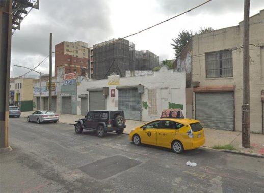
From the sidewalk viewpoint it appears as a nondescript garage-turned-church in a row of other automotive businesses and storefront churches in the shadow of the elevated Woodlawn Line. But look up at its neighbor’s wall. It does not line up perpendicular to the sidewalk. Its skew to the grid suggests a property line that predates urbanization.

From an aerial survey we see the garage curving across a block of otherwise rectilinear properties in a neighborhood that generally conforms to the street grid. Could it be covering a decommissioned road or railroad?

The 1921 G. W. Bromley atlas plate for Bedford Park shows the area as lightly developed with wooden single-family homes and a couple apartment buildings on Villa Avenue. The curved property has not yet been developed. Notice how it nearly touches the elevated Jerome Avenue Line, but they’re not related to each other.

An atlas page from 1893 depicting a couple of blocks to the east reveals the answer. Between 1866 and 1894 the site of Jerome Park Reservoir was a thoroughbred racecourse. A spur of the New York Central Railroad branched off the Harlem Line near the Botanical Garden, running for a mile to the racecourse’s dedicated station. The arrangement resembles the Meadowlands and Belmont Park spurs that are in use only during sporting events. Notice how Mosholu Parkway was mapped as a parkway but not yet laid out. For now, Schuil Brook is seen flowing on the future roadway. Grand Concourse has not been laid out yet, with Anthony Avenue as its precursor in this neighborhood. With the closing of the racetrack the line was abandoned and unfortunately no photos exist of it in operation except…

With the transformation of the former racecourse into a reservoir, earth had to be carved out on this hilltop, transforming it into a massive crater. Railroad cars were used to take the earth out of the site, as seen in this 1901 photo from Scientific American Magazine. According to the author, trains departed from Jerome Park, likely using this old right-of-way, and then merging with the Harlem Line with some of dirt dumped in Bronx Park. The wagons then branched off on a temporary track on Pelham Parkway running to the wetlands along Westchester Creek, where the soil and rocks were used for land reclamation.

A visit to the garage inspired me to walk on and on the same block is an Art Deco IND substation serving a non-revenue spur of the Concourse Line that takes trains to the Concourse Yard. Gary Fonville documented all the active and former IND substations back in 2012. Built during the Great Depression, IND stations were minimal in design with endless bathroom tiles on their station walls. But the substations are works of art worthy of landmarking.

The substation makes for an ideal visual end to East 204th Street, the northernmost road to have an underpass beneath Grand Concourse. Because this street is only a third of a mile in length, it has the least traffic among the nearly dozen underpasses of the Concourse.
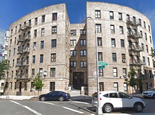
The Bronx is full of curved apartment buildings, especially in hilly neighborhoods where streets must follow topographic contours. 181 St. George’s Crescent is nearly a quarter of a circle, perhaps the most rounded low-rise building in the Bronx. The roundest one of all are the nearby Tracy Towers which are the tallest buildings in this borough. I’m not sure why this crescent is named after England’s patron saint. Perhaps it relates to a church, or the favorite saint of a landowner or developer.

Plenty of ink has been spilled about the Art Deco grandeur of apartment buildings on Grand Concourse, but not as much about neighboring streets and avenues which have their own examples to share. At 185 St. George’s Crescent, the main entrance appears as an oversized futuristic kiosk.
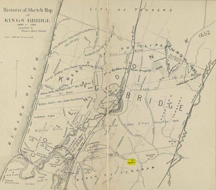
Another fascinating aspect of this crescent is its revolutionary past, as seen on the 1887 map by Thomas Henry Edsall. Among the forts set up by the patriots to stop Gen. William Howe’s redcoats, Negro Fort is the one with the least documentation. British attempts to woo enslaved Africans to the loyalist cause in exchange for freedom are well-known but there were also many blacks who fought for the revolution in exchange for personal freedom. Was this fort manned by black rebels or black loyalists?
The few sources available seem to hint at both sides, depending on who controlled the fort. But it was written that they originated in Virginia, where Lord Dunmore issued a proclamation to slaves offering them freedom in exchange for loyalty. Most did not survive the war, and after it ended they fled to Nova Scotia, and then to Sierra Leone. No trace of Negro Fort remains.
More from Sergey Kadinsky
Gunhill Road, Williamsbridge
Melrose Commons
The Montauk Cutoff
Sergey Kadinsky is the author of Hidden Waters of New York City: A History and Guide to 101 Forgotten Lakes, Ponds, Creeks, and Streams in the Five Boroughs (2016, Countryman Press) and the webmaster of Hidden Waters Blog.
Check out the ForgottenBook, take a look at the gift shop, and as always, “comment…as you see fit.”
12/9/19
10 comments
This is fascinating. Great find Kev !
The History Channel covers the topic of an escaped slave who escaped to Nova Scotia & found wealth in “The Curse Of Oak Island”:
https://www.reddit.com/r/OakIsland/comments/7u11b2/samuel_ball_found_the_treasure_proof/
A bunch of photos of the construction of the Jerome Park Reservoir is available in the NY Historical Society site. A key map inset showing the link from the Jerome Park RR and the construction RR that went through Bronx Park. The Jerome Park Construction RR was extended back across Webster and across the NY Central and across Bronx Park to Allerton Ave where it went South on what became Bronx Park East and then turned East to become the Great Swamp RR to van Nest and then to Hunts Point.
Fascinating as always!
At Bedford Park Boulevard, the #4 Jerome Ave. elevated line jogs a big west of Jerome Avenue, because the Avenue itself follows a sharp, crescent-shaped right of way for about three blocks. For that reason, the #4 line station is about 100 feet west of Jerome Avenue, and the station house is atypical of IRT and BMT dual contracts routes in The Bronx, Brooklyn, and Queens. It rests on a slab closer to street level, instead of being suspended from the underside of the elevated structure.
Elevated lines following a private r.o.w. adjacent to their namesake streets are very common in Chicago, but rare in New York. The only other examples that come to mind are Seneca Avenue, Forest Avenue, and Fresh Pond Road on the M line in Queens.
If you look at the rear of the property on Moshulu between Bainbridge and Hull you can see the continued routing…there’s a property that’s abnormally slim on the next block that further continues the visual signs…
Many years ago, and old-timer that lived on Decatur Ave mentioned this his house was built on an old railroad right of way. It was a small house nestled between two apartment buildings. I had no idea what he was talking about. A few years later, I rented garage space in a private house on the corner of Bainbridge Ave and E Mosholu Parkway North. After a while I noticed that the apartment building that adjoined the corner house came to an odd point. It was not rectangular. I never knew why. Years passed and then one day I saw an old map in the Westchester County courthouse which showed the rail link to Jerome Park. I was fascinated and then, since we were now in the age of the internet, I did some research and learned how the rail spur curved out past the 52nd Precinct, across Webster Ave and then across Decatur Ave, Hull Ave, Perry Ave, exited at Bainbridge, by that odd shaped apartment building and right next to my old garage. (Just north of Sam’s Carpets on Webster Ave, there is a gas station, now, but if you look there are series of very narrow houses that conform to the looping turn of the rail spur as it crossed each of those streets). The spur crossed what’s now Mosholu Parkway (although there is no trace of it’s crossing) and then proceeded behind the buildings on the South side, parallel to 204th St. coming out just south of 204th St and the Grand Concourse, looping around to the semi circular garages in the aerial view as it approached Jerome Ave. Talk about history being hidden in plain sight!
Since were’ on this subject Kevin, see if there are still remnants of the LIRR or their predecesors siding to the Con Ed property in Flushing. It cut off just past the Flushing creek and went to the plant, probably for coal deliveries. When It cut off the main trackage, it ran between houses with one house set back for the tracks to run in front of it
As I read my own comment I left out the word “former” in relation to the Con Ed property. It’s where the combo shopping plaza/apartment building is now. The street is 40th Road.
The story is not comprehensive and you haven’t answered your question. Try circling the area in question on the map. Also the atlas of 1893 does not show how the curve and the racetrack are related. Please address.