
By SERGEY KADINSKY
Forgotten NY correspondent
When two railroad lines nearly touch each other, it made sense at the turn of the 20th century to build a connecting spur between Sunnyside Yard/Main Line and the Lower Montauk Branch of the Long Island Railroad. Only a third of a mile in length, it enabled freight trains to run between the massive railyard and the Montauk Line and its yards. It also provided access to the Degnon Terminal freight tracks that fanned out on the streets of Blissville. The spur also enabled empty passenger trains to switch between the Main and Lower Montauk lines.

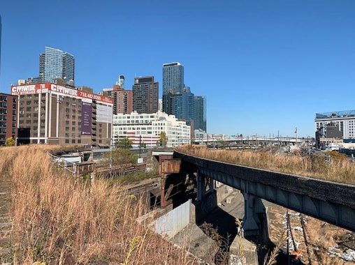
As seen in 1908, the area was filled with train tracks serving the docks, factories, and warehouses of Long Island City. The road running diagonally on this street grid is Jackson Avenue, the westernmost segment of New York State Route 25A, which ends its 73-mile run near the North Fork of Long Island. But in its last three decades of operation, freight usage greatly declined and passenger trains no longer needed it for turning around. The MTA sought to divest itself of the costly tracks and nature slowly reclaimed the Montauk Cutoff.

Although the last train rain on these tracks in 2015, one signal on the route remains lit for the ghost trains whooshing through the wild grass. As abandoned lines are concerned, this one has no fences or security, making it easily accessible for urban explorers. Nathan Kensinger was here, so was the LTV Squad and Untapped Cities. The history site Trains are Fun has a detailed profile on this spur, so I’ll let them tell the story. The Montauk Cutoff offers the appearance of the High Line before it was transformed into an overcrowded selfie hangout.
In the summer of 2017, the track connection was forever severed between the Montauk Cutoff and Sunnyside Yard with the yard’s upgrade to accommodate the East Side Access project’s mid-day storage yard. The flyover tracks atop Sunnyside Yard no longer make their landing to merge with the tracks below. Their tips have been demolished and at some point the entire flyover trestle may either be removed or transformed into a green walkway.

From this trestle one can see the residential towers rising on the site of 5 Pointz, the former Neptune Meter factory that hosted New York’s largest display of outdoor graffiti from 2002 through 2013. But then property owner Jerry Walkoff realized that there’s more money to be made in upscale high-rise residences. Two towers rise on this site, at 41 and 48 floors, containing 1,115 units, with interior murals to honor the history of this property. The 7 subway line rises from its tunnel on a parallel flyover track that takes it to Queensboro Plaza and beyond. In the heyday of 5 Pointz, straphangers could observe the graffiti murals from the windows of the passing subway train.

To the south of Sunnyside Yard, one can compare the glassy skyline of post-millennial LIC to Dubai and Shanghai. The only transit investments made to accommodate the new residents are bike lanes and the NYC Ferry stop at Hunters Point South Park. There has been talk of building a new Long Island Railroad station in Sunnyside Yard that would provide a one-seat ride to points east, but these things take decades and billions of dollars to complete. It would be nice to have Amtrak stop here too, but that requires too many government agencies having to cooperate with each other.

Shade here is provided by the Midtown Tunnel approach of the Long Island Expressway, which rises above Blissville to cross Dutch Kills. The metalwork and industrial neighborhood below give this viaduct a resemblance to Pulaski Skyway in Newark.

The concept of a missed transit opportunity brings to mind the 1992 study that sought to use the Montauk Cutoff as part of either a new subway line or train line that arrived in Queens via the 63rd Street Tunnel, and then turned south at Sunnyside Yards, where it would have a station at Thomson Avenue. It would then use the Montauk Cutoff to access the Lower Montauk Branch. Former Councilwoman Elizabeth Crowley of Middle Village still seeks to revive the Lower Montauk for passenger service, but without the tunnel connection to Manhattan. Her proposed line would end in Long Island City.

The more popular plan for the Montauk Cutoff replicates the High Line by encasing the tracks in an elevated walkway that would highlight renewable energy and nature along the way. To date, only the abandoned Degnon Terminal spur has been given up by LIRR for green space, the Smiling Hogshead Ranch, a community garden at Pearson Street and Davis Court. As we’ve seen with the proposal to transform the abandoned LIRR Rockaway Beach Branch into the Queensway park, this is not Manhattan and park plans here take much longer to become reality, if at all.
Kevin Walsh documented the Degnon spur in 2002, nearly a decade before the gardeners arrived. The deactivated track was still visible, but hasn’t had trains on it since 1985. His report on the tracks included mention of the other nearby spur that took freight cars to the water’s edge on the East River. That spur ran along 48th Avenue for three blocks. Following the abandonment of the spur in the early 1990s, the trench was filled and developed as Hunters Point Community Park.

The tracks end a few feet west of Jackson Avenue. Perhaps in the distant future this dead-end and the park above it could be used as the right-of-way for another train tunnel to Manhattan. For now, this track is part of the Arch Street Yard.

If the environmental advocacy group Riverkeeper has its way, the entire Montauk Cutoff and the Dutch Kills waterway would become publicly accessible as a parkland loop. As part of its Newtown Creek Vision Plan, the area would receive a massive cleanup and transformation beyond recognition. How realistic is this vision? One can see precedent in Concrete Plant Park on the Bronx River of a shoreline transformed. There’s still plenty of industry on the tidal section of the Bronx River, but now with pocket parks filling in the voids.
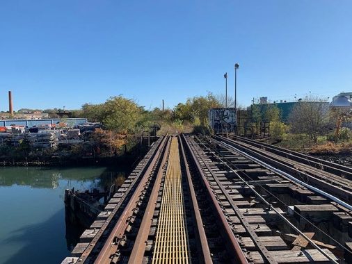
The Montauk Cutoff crosses Dutch Kills atop the M Cabin Bridge, a lift bridge that has not been raised in decades. There are huge gaps here between the rail ties and the water below is nearly as inhospitable as Gowanus Canal.

The swing drawbridge of the Lower Montauk Line is in active use, but I can’t say when it was last swung for a passing vessel. The next bridge upstream on Dutch Kills is the historic Borden Avenue swing bridge, one of only two of its kind in the city. Going east, you can explore Blissville, stay at the City View Inn, walk across the new Kosciuszko Bridge, hike the hilltops of Calvary Cemetery, see the tiny public park inside it, and take a long walk from there to Woodside.
Sergey Kadinsky is the author of Hidden Waters of New York City: A History and Guide to 101 Forgotten Lakes, Ponds, Creeks, and Streams in the Five Boroughs (2016, Countryman Press) and the webmaster of Hidden Waters Blog.
Check out the ForgottenBook, take a look at the gift shop, and as always, “comment…as you see fit.”
11/10/19
11 comments
Part of the 48th Avenue spur still exists. It runs under Vernon Avenue and stops in a trench on the west side. Street level LIRR property continues about half way to 5th Street where the park begins. Google maps shows the whole area as a park
I think you mean Jackson Avenue instead of Vernon Avenue.
Under Vernon Blvd the trench has been filled in. There was a gas main strapped to the west side of the bridge prior to the work and now that is direct buried.
And I have a question: I always saw these small flat cars on that Montauk cut off that never seemed to move. What were they for?
Hey Tom, those little blue cars are called bogies. They were the LIRR’s failed attempt at transporting trailers over railroads in the 1980s. Bogies were also needed because most infrastructure in NYC was built way before tall intermodal rail cars existed, meaning that transporting freight would be difficult because of low ceilings. Bogies accomplished this by having trailers sort of sunk inside them. If this experiment would have succeeded, it would have massively reduced the amount of trucks on New York and New Jersey Highways. The project was scrapped and so were the bogies (literally) because they were prone to derailment and other issues.
Matt, thank you very much for the feedback. Another mystery solved
Thank you very much. Another mystery solved
What would be the point of having a “High Line” type of walkway at this location? Who would use it, other than a bunch of railfans who want to see trains and tracks from a higher perspective? There is nothing to see there.
Exactly. People are so obsessed with this craze of parks out of abandoned infrastructure they don’t think twice about how it will actually impact people and if it would be used. The entire spur literally leads to nowhere, and a better way to spend money would be on some sort of shuttle or 4 car line like the G using the old Montauk rails.
Whatever it turns into, I will miss it dearly. I walk it usually once per season, though it’s most wonderful when snow is on the ground. It’s such a peaceable and other worldly island in this crowded city of ours. Can spend hours out along the bridge or at the northern end, watching the 7 rumble by. I’ll enjoy it while I can and then welcome any progress when it comes, as it’s far too selfish for folks like me to keep it for ourselves. After that I’ll cross it and then just move onto the other haunts which fallen through the cracks of progress.
Would this former route be part of the East Side Access when it gets built or is that going a different route?
Nowhere near