
I traveled to Sunset Park on a humid, overcast afternoon in September to take a look at some railroad tracks. A few days earlier, I had been horrified to see that several stretches of disused street railroad tracks had been pulled out and paved over in DUMBO (I will post pictures from that effort sometime soon) and, after reading a local newspaper report that the city was planning to do the same in Sunset Park I decided to head over and see what I could see of them before the city takes any action. Sunset Park is, of course, no stranger to Forgotten New York annals and I have composed several pages on the neighborhood adjoining Bay Ridge, where I spent my first 35 years; I rode the B37 and B63 buses regularly through the area.
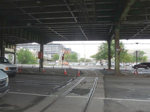


Many Sunset Parkers and Costco patrons are unaware that there are active railroad tracks crossing 3rd Avenue at 38th Street, a freight railroad known as the South Brooklyn Railway that connects the waterfront with D train tracks. Today, freight is carried to the Coney Island Yards via these little-used tracks.
It wasn’t all that long ago that the sight of a freight train rumbling down much-traveled Brooklyn thoroughfares wasn’t that unusual a sight. The South Brooklyn Railway (SBK) is the NYC Transit Authority’s (now MTA’s) very own freight line; it runs from the TA’s freight yard at 39th Street and 2nd Avenue west and south to the Coney Island Yards.
The line ran along 2nd Avenue, then shared tracks with the IND/BMT subways in an open cut/tunnel from 4th Avenue to the 9th Ave yards. It then ran at grade under the Culver Line all the way south to the Coney Island Yards, with the SBK running on McDonald Avenue from Cortelyou Road south to beyond Avenue X.
The bread and butter of the SBK in its heyday was the delivery of boxcars from all over North America to businesses that were situated close to the tracks along the Culver right of way. The freight would be floated on barges from New Jersey and then transferred onto cars at the 2nd Ave. yard where SBK locos would pull them to their destinations. The SBK arose from one of the many different passenger and freight railroads that ran in Brooklyn before subway service arrived in the early 20th Century, the Prospect Park and Coney Island Railroad, which for much of its route ran along Gravesend (now McDonald) Avenue. For part of its route the SBK used trolley tracks on McDonald Avenue, making it the only line associated with the TA that used both subway and trolley tracks.
The SBK connection to the Culver was severed in 1978, and tracks on McDonald Avenue were pulled out during the 1980s. Today, the SBK tracks connect with the West End line tracks via a switch between 4th and 5th Avenues.
If they could talk, the SBK tracks would have a lot of stories to tell. According to NYC transit historian/hockey maven Stan Fischler in the classic Uptown, Downtown…
— It was once attempted to haul a dead whale along the SBK to the Coney Island Yards, where it would be trucked to the Coney Island Aquarium. The whale had been killed and embalmed in the North Atlantic and shipped to the SBK yard. The whale was strapped onto a flatcar and a loco began to haul it along the SBK. The whale got as far as the tunnel south of 4th Avenue, but wouldn’t fit in the tunnel.
— The SBK also hauled a downed Army plane that crashed in Pennsylvania to the Coney Yards and then the pieces were trucked over to Floyd Bennett Field on Flatbush Avenue for an inquiry.
— The SBK did a lot of business with the many Brooklyn breweries that flourished pre-Prohibition. It also did a good business hauling wine grapes for Brooklynites who flouted the law during Prohibition.
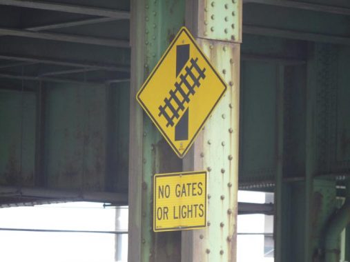
Though this is a grade crossing it is not guarded by gates and lights due to infrequency. Presumably, flag(wo)men stop traffic when a freight is proceeding through.
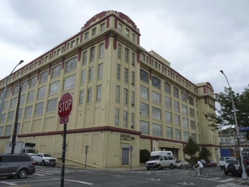
This impressive-looking building at 3902 3rd Avenue once boasted a pyramidical cornice. It’s also the first house on 3rd Avenue whose house number matches up with the street; north of here, on 3rd, 4th and 5th Avenues, buildings are numbered from #1 to about #1000 (#888 on the shorter 5th Avenue).
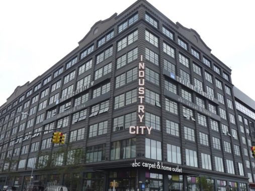
Several monolithic buildings were designed by architect William Higginson in the first 3 decades of the 20th Century for industrialist Irving T. Bush, between 29th and 39th Streets and 2nd and 3rd Avenues. There are 15 lofts in total, each 6 to 8 stories in height, fully 200 acres of land given to vast warehouses and manufacturing lofts. Bush Terminal had a waterfront railroad and 18 deep water piers.
Today Bush Terminal is becoming a beehive of activity in the telecommunications field, as many of its buildings have been converted by Industry City Associates into broadband services providers, paving the way for digital broadcasts over the internet and high-speed internet. A bid for further Industry City development was opposed by area politicians, leading to its cancellation (similar to opposition to the Hunters Point Amazon facility).
The above building, 3906 2nd Avenue, serves as training facilities and offices for the Brooklyn Nets NBA basketball club (sponsored by the Hospital for Special Surgery), with an ABC Carpet store on the ground floor.


Though most of the tracks found on 1st and 2nd Avenues and side streets in Sunset Park belonged to freight railroads (see above and below) there were indeed trolley tracks in Sunset Park, and this pavement exposes some here on 2nd Avenue between 39th and 40th streets. Several trolley lines converged at the waterfront, running along 39th Street, as there was a ferry line connecting to Manhattan throughout much of the 20th Century at the street’s foot at Gowanus Bay. Today the B70 bus dutifully runs to 1st Avenue, serving a ferry out of business for decades.
Today a NYC Ferry route does serve Sunset Park but the landing is at the Brooklyn Army Terminal at 58th Street.
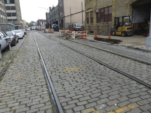
On 41st Street between 1st and 2nd Avenues is an insane combination of Belgian block pavement and RR freight tracks. These tracks are no longer active but once belonged to the New York Cross Harbor Railroad.
In 1999, I snapped a picture seen on this FNY page of BEDT (Brooklyn Eastern District Terminal) #16, the last steam engine in regular service in New York City, waiting in the Bush Terminal Cross Harbor RR yards on 1st Avenue. #16 had worked Brooklyn waterfront freight service until 1963 (by contrast, the last LIRR steamer was retired to museum pasture in 1955). Subsequently, the steam engine was taken by flatbed car to the Long Island railroad Museum in Riverhead.
The New York Cross Harbor Railroad, which still plies 1st Avenue from a 50th Street carfloat pier along 1st Avenue to the Brooklyn Army Terminal, provides New York with a rail freight link to the rest of the North American rail system using a small fleet of carfloats. This cross-harbor route eliminates the need to run over 280 extra miles up the Hudson River and then over down the Hudson line. The NYCH primarily serves Long Island via interchange with the New York and Atlantic Railroad at Fresh Pond Yards and southern New England via NYA and CSX/CP, via the New York Connecting Railroad running through Glendale and Jackson Heights, Queens.
The NYCH has two locations: Greenville, NJ where interchange with CSX and NS takes place and Bush Terminal, Brooklyn where interchange with NYA and the South Brooklyn Railway (SBK) takes place. A statue of terminal founder Irving Bush can be found at the yards’ administration building. The NYCH is the result of a consolidation of two Brooklyn waterfront railways. The New York Dock Railway and the Brooklyn Eastern District Terminal (BEDT) merged in 1983 to create the NYCH.
This railroad’s business is primarily moving and interchanging freight cars from New Jersey via carfloats. Although there were once dozens of carfloat bridges along the Brooklyn coast, today only one remains in service, just west of 50th Street and 1st Avenue. Once tugged over, cars are interchange with either the New York City Transit Authority via the South Brooklyn Railway or the Long Island Railroad freight division (now the New York and Atlantic RR).
The NYCH also moves a good percentage of the nation’s cocoa by floating it from the Brooklyn shipping ports to the mainland. The Cross Harbor also delivers carfloats to various docks around the Brooklyn port area.
In times past, the New York Dock Railway interchanged freight with the New Haven which were responsible for the former electrification of the Bay Ridge freight line. Interestingly, two carfloat bridges/gantries of the LIRR in Long Island City have been restored an turned into a recreation area called Gantry Plaza State Park.
Sources: Daniel Boyar; Uptown, Downtown by Stan Fischler


This pair of crosshatched crossing signs appear at 41st and 42nd Streets on either side of 1st Avenue, warning about freight trains that periodically run on 1st Avenue toward waterfront locations.


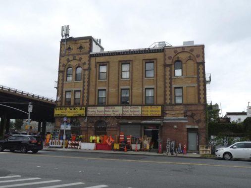
This hulking tower scowls over 1st Avenue and 42nd Street…is it an abandoned church, gutted by fire? The ruined home of an 1890s railroad baron perhaps? The Xanadu of a New York City Citizen Kane maybe?
No, it’s merely the old National Metal Meter Company Building, according to the AIA Guide, on the outskirts of Bush Terminal. It has been renovated in recent years, but its formerly imposing tower’s apex has been removed.
(The AIA Guide to New York City misidentifies it as National Metal)


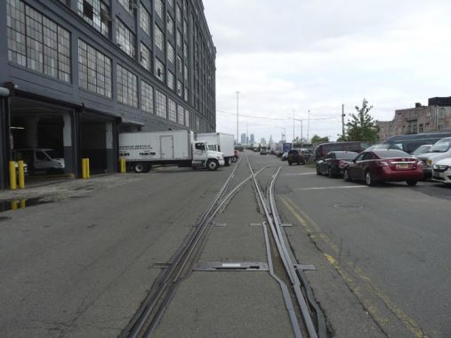
The active tracks enter a railyard off 1st Avenue between 43rd and 51st Streets (south of there, they run on 1st Avenue). Some disused cars are laid up. The logo on the tanker car, North Dakota Mill, refers to the US’s largest grain refinery located in Grand Forks, ND, in business since 1922.
I have always been impressed with this immense manufacturing loft building at 4312 2nd Avenue. The sign over the side entrance reads “Commodore Mfg. Corp. Criterion Bell & Specialty.” Real estate site The Real Deal reports that Commodore formerly stored Christmas decorations in the building, but in more recent years the NYPD has leased 174,000 square feet in the building and uses it to store seized property used for evidence in court cases.
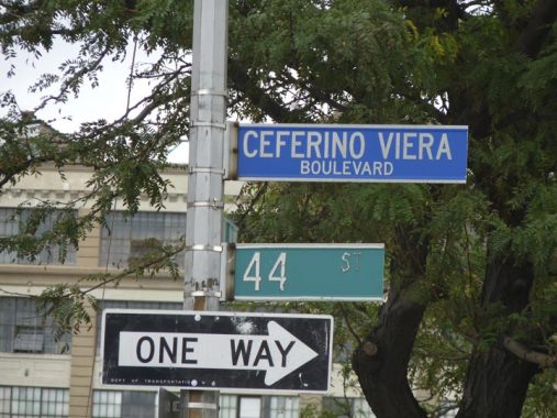
44th Street between 2nd and 3rd Avenues is subnamed for Ceferino Viera (1922-1991) a WWII and Korean War veteran who worked as a cab driver and tried to rid Sunset Park of the drug scourge. He was run over by a van driven by a drug dealer in 1991.
The Department of Transportation formerly used blue for honorific signs; they changed to green (with blue reserved for police officers and red for firefighters) in recent years.


I walked down 44th and then 43rd Streets, mainly because I had never or rarely done so. On 44th between 2nd and 3rd are a pair of stolid brick manufacturing buildings, both with indicators of former uses, textile manufacturing (Tie King) and Webster Paper Box Corp.
I think two ties have seen me through the last 30 years…
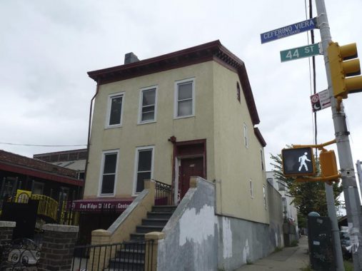
Today 314 44th Street is at the SE corner of 3rd Avenue and 44th Street. However, when it was photographed in 1940 there were buildings on each side of it. The reason for this is that 3rd Avenue was widened when the Gowanus Expressway, the southern end of the BQE, was constructed and several hundred houses on the cross streets east of 3rd Avenue were demolished.
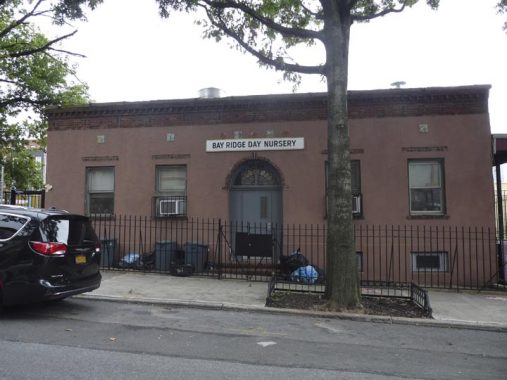


The one story building next to it, the Bay Ridge Day Nursery (so called even though this is in Sunset Park) has apparently always been used as a school, or perhaps a place where children are cared for, judging by the small ceramic squares near the roofline attest: Bo Peep, searching for sheep; the milkmaid who gets propositioned; Jack and Jill ascending their hill; and King Cole and his fiddlers. A cornerstone on the building reads “1935.”


I moved over to 43rd Street at 4th Avenue since there are a number of architectural sights to be seen there. The first is the incredibly tall, 200-foot high campanile of St. Michael’s Church, a parish founded in 1870; the current church, designed by Raymond Almirall, was dedicated in 1905. That year, it was the tallest building in Brooklyn and was later succeeded by the Williamsburg Bank tower now called One Hanson in 1928 (which itself has been succeeded a couple of times since).
Though the adjacent St. Michael’s parish school was closed in 2005, the building still hosts PS 522. The chiseled in identifier still appears on the facade, along with an incredible “AE” ligature. The combo “ae” doesn’t appear much in English, mostly in Latin loanwords, but it’s survived over the centuries in the given names Michael and Raphael, both Archangels in the Christian canon. Rarer still is the printed ligature for capital AE; you see it often in the lowercase combo. I’ve only ever seen it in print for the Latin name AEgyptus.


Sunset Park’s architectural riches are also manifested across 4th Avenue from the 68th Precinct and St. Michael’s Church at 4201, where stands the former Sunset Park Court House or Magistrates’ Court, a relatively recent addition from 1931 (Mortimer D. Metcalfe, arch.). It was one of four ‘regional’ courthouses that handled local cases before courts were centralized on Brooklyn’s Legal Row on Cadman Plaza West in 1962. Defendants processed in the 68th Precinct across the street were arraigned here. Grand Ionic-columned entrances appear on both the 42nd and 43rd Street sides.
After the court moved out in 1962 the building was used for decades as offices by Community Board 7 and later as a police training venue. After several years of disrepair, it was renovated in 1996. Montrose Morris has more in Brownstoner. In 2020, it was the temporary Sunset Park Brooklyn Public Library branch.
Neither of these buildings is landmarked: but the old 68th Precinct, on the west side of 4th Avenue at 43rd Street, is: yet, it is seemingly forever encased in protective scaffolding, since the building is literally falling apart. I have photos of this building on this FNY page.
Though other parts of Sunset Park have been award Landmark status by the Landmarks Preservartion Commission, I’m surprised 43rd Street between 4th and 5th Avenues hasn’t because its near pristine attached rowhouses are nearly perfectly preserved by their various owners.
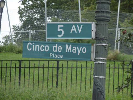
5th Avenue on the west side of Sunset Park has been subnamed Cinco de Mayo (5th of May) Place between 41st and 44th Streets. Contrary to what some believe the 5th of May does not mark Mexican independence; instead it celebrates General Ignazio Zaragoza’s victory over the French at the Battle of Puebla, May 5, 1862. Mexico declared independence from Spain September 16, 1810. France invaded Mexico in 1861 (Mexico had defaulted on massive debts to France and other European countries) and ruled it from 1864-1867.
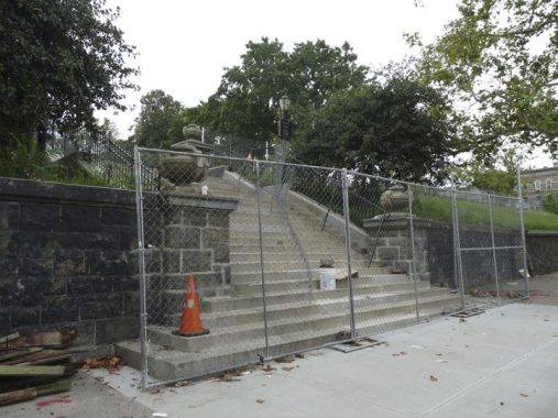
Entering Sunset Park was rather problematic in mid-2020 as both the 43rd and 44th Street entrances at 5th Avenue were blocked (harking back to the high-crime 1970s and 1980s, when the entrances were also closed). Only the 41st Street entrance at 5th Avenue is accessible.
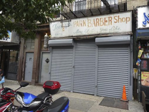
Tony Garofalo owned Tony’s Barber Shop on 5th Avenue south of 44th Street from 1964 until his death in 2020. That may be the original painted sign. According to Garofalo in 2015, the shop had been there for a century. Some interior photos can be found at Messy Nessy Chic.


Walking up 44th Street on the south side of the park — a block I had never walked on before — I was absolutely fascinated by this pair of apartment buildings at #568 and #570, with their incredible wrought iron entrance canopies, inlaid with green terra cotta. According to the LPC report,
[These] Renaissance Revival flats building[s were] designed as a pair with 570 44th Street by Eisenla
and Carlson for Louis Stechen in 1913.
However I was also surprised to learn from the Report that these buildings became Finnish co-ops in 1922, joining other such co-ops in this corner of Sunset Park.
The blocks between 40th and 44th Streets were home to a substantial Finnish population. Finland is in Scandinavia (with Norway, Sweden and Denmark), but its language is from a different root and is unlike Danish, Swedish or Norwegian. In Finland, the country is called Suomi; the word doesn’t resemble other Scandinavian country names’ English counterparts such as Sverige, Norge and Danmark.
On 43rd Street between 8th and 9th Avenues, we find the first cooperative apartment in the country, founded by 16 Finnish immigrant families in 1916. The first of these coops was located at #816 and was called Alku, or “beginning.” A gold leaf sign on the doorway identifying it has been lost in recent years, but the second such co-op, Alku Toinen, “Beginning II” is chiseled in and still remains at #826.
Montrose Morris weighs in on the Finnish co-ops in Brownstoner.


I went into Sunset Park for its unparalleled views. While the day was hazy and rather cloudy, Liberty, the Pulaski Skyway, the New Jersey hills and Manhattan could be made out nonetheless.
I discuss Sunset Park as well as the Finnish co-ops in somewhat more depth on this FNY page from 2017.


Elmo Homes, #728 44th Street, may or may not have been part of the Finnish co-ops, but I liked the name.


I wrapped up the walk at the 9th Avenue D train station, one of the BMT’s station houses of which I’m so fond. These BMT headhouses unfortunately were considered afterthoughts by the MTA and its predecessor agencies for much of the latter 20th Century. Recent management, though, appreciates what they have in these buildings, constructed in an Arts and Crafts style mostly in the 1910s. Many have been recently been renewed and renovated; the Sea Beach line station platforms and stationhouses were all redone from 2016-2019.
The artwork is Christopher Russell’s “Bees for Sunset Park.” (We’re close to the undefended border of Borough Park and Sunset Park, which to me runs down 9th Avenue or Fort Hamilton Parkway.)
Russell:
The station is like a kiosk, and it reminded me of beehives — of people coming in and out of it, and doing their jobs. I began to think about the great gates that Gaudí did. He came from a family of ironworkers, and there’s a fantastic dragon gate he did in Barcelona.
Metalwork and gates were definitely an aspect of the Arts and Crafts tradition, and that was very much on my mind. I also thought about Mackintosh and his buildings in Glasgow. NY Times
Check out the ForgottenBook, take a look at the gift shop, and as always, “comment…as you see fit.”
10/4/20
13 comments
Thank you for a very comprehensive report on an area not far from Bay Ridge that I did not visit very frequently.
“It wasn’t all that long ago that the sight of a freight train rumbling down much-traveled Brooklyn thoroughfares wasn’t that unusual a sight.” It was a common sight for me in the 50’s and 60’s to see freight trains rolling down MacDonald Avenue, growing up near the Parkville Yards as I did. You might want to change “fright” to “freight” as in “TA’s fright yard at 39th Street”. Or maybe not with Halloween coming up. Keep up the good work!
Thoroughly enjoyed your posting but I was wondering what happened to The St. Michael’s high school. When I was in grammar school this was the nearest Catholic High School in the area. I was hoping to attend it in the fall of’ 1957 but it closed either in the fall of 1956 or the summer of 1957. Did the elementary school take over the building, or was the high school further down 44th street? I always thought that the building on 4th ave. was the high school.
St Michael’s Diocesan High School was one of the three original Diocesan High Schools in the Brooklyn Diocese. The High School is adjacent to the grammar school, also now closed, and fronts on 4th Avenue. It closed in 1956 and was succeeded by XaverianHS on Shore Rd. Xavarian is not a Diocesan school; both schools were/are staffed by Xaverian brothers. The building was in poor shape in its last years and was quite small; there was a major expansion of the diocesan school system in the early ’60’s, many of those schools are now closed.
Kevin- the large brick building on 1st Ave and 43rd St isn’t the National Metal Company building, it’s the National METER Company building. The AIA Guide, and its previous editions, have all had this typo for decades! I wrote a book about factory buildings throughout Brooklyn and Queens, and couldn’t find any info on the National Metal Company, so I typed the building’s address into GoogleBooks, and got dozens of hits for National Meter. Mystery Solved!
https://noveltytheater.net/buildings/national-meter-company
https://www.google.com/books/edition/Report_of_the_National_Conference_on_Wei/oFwiAQAAIAAJ?hl=en&gbpv=1&dq=national+meter+company+brooklyn+1st+ave&pg=PR12&printsec=frontcover
“What began with one man at the beginning of 1870 has grown over the past century and a half into one of the
largest gas, water and oil meters and power tools manufacturers in the world, with 17 separate divisions located
across the nation. Known as Rockwell Manufacturing Company until the turn of the 21st Century with its
executive offices in Raleigh, this conglomerate was the brainchild of Irish immigrant John C. Kelley. Moving to
America soon after his birth in 1839, Kelley relocated to Cincinnati during his teenage years. By the 1860s,
Kelley had moved to New York in search of employment, and in January 1870, he founded the National Meter
Company, initially manufacturing water meters. Kelley served as the company‟s president and its chief
engineer and salesman, positions that he held until his death in January 1914. After several years of slow
financial growth, by the 1880s, National Meter purchased the inventor Lewis Nash‟s “Crown” meter. This
acquisition allowed the company to rapidly expand their clientele, which included a large portion of the
municipal buildings in Providence. By the middle of the first decade of the 20th Century, National Meter had
produced over 500,000 meters, manufacturing an additional 500,000 products within the next seven years,
employing over 1,000 people at their multiple plants from Boston to Chicago, with company headquarters at 84
Chambers St. After Kelley‟s death, the company continued to prosper until its acquisition by the Rockwell
Manufacturing Company in 1941. Rockwell was formed from a merger of separate meter companies over the
course of several decades. The first such firm was George Westinghouse‟s Pittsburgh Meter Company, formed
in 1886, becoming the Pittsburgh Equitable Meter Company in 1927. 14 years later, this firm relocated to
Brooklyn, merging with National Meter at this plant to become the Rockwell Manufacturing Company, headed
by Willard Rockwell. This facility produced Pittsburgh and Empire water meters, with a machine shop and
foundry on the bottom three floors, and a drafting a photograph darkroom on the top floor. By the 1950s, the
top two floors contained offices. Throughout the second half of the 20th Century, Rockwell expanded his
operations into California, where valves used in the chemical and petroleum industries were produced, to
Tupelo, Mississippi and Columbus, Ohio, both manufacturing sites for power tools and circular saws. By the
1970s however, Rockwell had vacated this site, and it now serves as a hub of small manufacturers, distribution
centers, and designers, from sporting goods and furniture makers, to the warehousing operations for renowned
Brooklyn-based food and spice purveyors Sahadi‟s.”
Wilco, will fix
Also, the massive factory building on 2nd Ave and 43rd St was originally built in 1917, for the American Can Company, which I believe you’ve talked about on your site before.
I took a snapshot of the national meter building sometime in the 1980s.Still got it in an album somewheres
So great! Many familiar sights to this SP resident, and it’s fantastic to learn the stories behind them. One small correction: Finland is Nordic, like the other countries you mentioned, but not actually Scandinavian, as it’s language (and people?) don’t share the same old German-speaking ancestors as the Scandinavian countries.
Not that long ago, there was an attempt to give a rezoning to Industry City, but it wound up being defeating. The claim was that it will bring numerous jobs, but many didn’t think that was really a promise. In al honesty, I feel that most of the new jobs are just already existing jobs that are relocated, which isn’t really giving new jobs to locals. If any jobs were new they would either be a very small number or ones that don’t pay that well hence the big opposition. Meanwhile, others just opposed it in believing that it will lead to gentrification.
Very familiar neighborhood, childhood nostalgia. Thanks for the detailed summary. Sincerely from Texas, Elaine Harmon
Thank you for your work
Fascinating.
By the way, saw the Model Garage place on 39th with the door open holy cow….
I lived in an apartment building on the NE corner of 3rd Ave and 44th st from 1960-66. Your picture of 314 44th was directly across the street. The family that lived there always had a vegetable garden next to the house. I attended St Michaels grade school. I also lived there when the Gowanus highway was built over 3rd Ave.