

While the other kids were out playing stickball, running in the street or causing various ruckuses in the age before Xbox, I was busy in my room doing a singular activity.
Perusing street maps.
I obtained my first full color street map of Brooklyn, a Hagstrom, at a Gertz department store in Jamaica, Queens in September 1968. My parents and I traveled all the way out there to purchase a “wall unit” for my father’s various tape recording equipment and collection of tapes, which had gotten quite voluminous. We must have taken the J train elevated all the way out to Parsons Boulevard (or the stop corresponding to it; that section of the Jamaica El was torn down in 1977-1978, and a new subway to Parsons Boulevard opened in 1989). That day, I remember the old man sending a steak back twice at lunch: he didn’t want any pink in the middle. (Today, gourmets and gourmands alike prefer steaks as rare as possible, but my father was adamant and me, I like just a bit of pink to make the steak chewable.)
Before getting that street map my interest in streets, their names, and street layouts had likely been sparked by the presence of a Geographia “little red book” listing the streets of Brooklyn alphabetically. A wealth of other information was included, such as cross streets and subway and bus lines. A small foldout black and white Brooklyn map was also tucked into the back of the book. Throughout the next two decades I collected as many Geographia and Hagstrom publications I could find in the metropolitan area; sent in corrections to Hagstrom, some of which made it into following editions; and interviewed for jobs at Hagstrom in 1981 and 1992, at their locations on West 33rd Street and on 54th Road in West Maspeth. I have kept 99% of the amassed map collection.
In the 1970s, I think, I embarked on a project that consisted of placing every street in NYC — about 9400 or so — in alphabetical order that would include all the boroughs, including every numbered street from 1st to 271st that would include all the various East, West, Bay, Brighton, Paerdigat, etc. streets in order, too. I printed them out in longhand. And I think I finished it! But somehow it got lost.
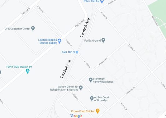
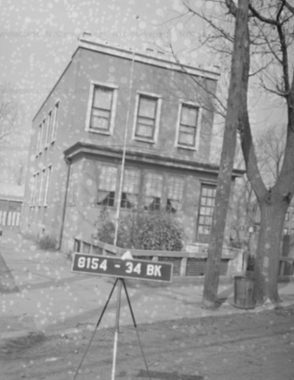
Way out on the Canarsie-Brownsville border, there was a street that intrigued me, running along railroad tracks from Farragut Road to Foster Avenue between East 102 and 105th Streets, that I saw on Geographia but not Hagstrom maps called Turnbull Avenue. It ran past the East 105th Street station, which used to be unique among all subway stations in NYC as it was accompanied by a grade crossing: a gate would come down when a train was approaching, and cars on East 105th had to stop till it went past.
Until 1973 this was the lone grade crossing in the NYC subway system, left over from the days when the Canarsie Line (today’s L train) was a steam railroad. The gates were hand-operated, and while there were a few more houses around, this was never a heavily populated area. You can see photos of its grade-crossing days on FNY’s Irresistible Lure of Canarsie page.
In 1974 I started bicycling obsessively all over southern Brooklyn. I found out much later that I had missed seeing this grade crossing by just one year. Since I was an idiot then, I didn’t carry any money with me and, one day when I got a flat tire, I had to hike all the way from Canarsie back to Bay Ridge, wheeling the bike, in lieu of getting the bicycle fixed. I did ride on the rim for stretches, but that was one heck of a walk on one of the hotter days of the summer.
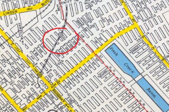
Here is a 2020 excerpt from Google Maps of the Canarsie Line (L train) tracks at their southern end. I have marked where Turnbull Avenue used to run, alongside the tracks. East 105th Street used to run through between Foster Avenue and Farragut Road, but after 1973, dead ends were placed on either side of the tracks. The tracks still run at grade: but the street does not cross over them anymore.
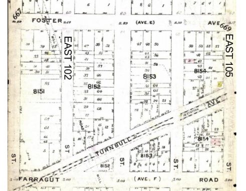
This 1912 map shows Turnbull Avenue running on either side of the railroad tracks. The Canarsie Line once ran only between Atlantic Avenue and a Canarsie terminal at today’s Rockaway Parkway as a surface railroad pulled by steam engines. In 1906 the Canarsie was acquired by Brooklyn Rapid Transit and was extended from the Fulton El in an elevated section south to New Lots Avenue; south of that, it ran “at grade” or on street level, though it ran on electrical power from a third rail. From 1924-1932 it was extended in underground subway sections north and west into Manhattan as part of the reconstituted BMT, or Brooklyn-Manhattan Transit.
Moving forward to 1929, Turnbull Avenue remains mapped alongside the Canarsie tracks. On Belcher Hyde atlases, paved streets were shown in purple — thus, none of these streets were paved though we do see a couple of houses, represented by brick red and yellow boxes, popping up here and there inclusing a couple on Turnbull Avenue.
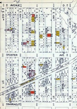
This 1949 Hagstrom shows the East 105th Street station but ignores Turnbull Avenue. Hagstroms were occasionally maddening in that they ignored existing streets, but showed entire neighborhoods of nonexistent ones, relying on official city maps that showed streets that were laid out but not yet constructed.
Note that all the cross streets are shown intact. It’s quite likely that none were built exactly as shown, since only East 105th and East 108th are through streets today (consult the above Google map from 2020).
The 1940 Municipal Archives shows three completed buildings on Turnbull Avenue. These three buildings must have faced the railroad tracks, and whoever lived there must have put up with some kind of racket from passing steam engines, later electrified subway cars.
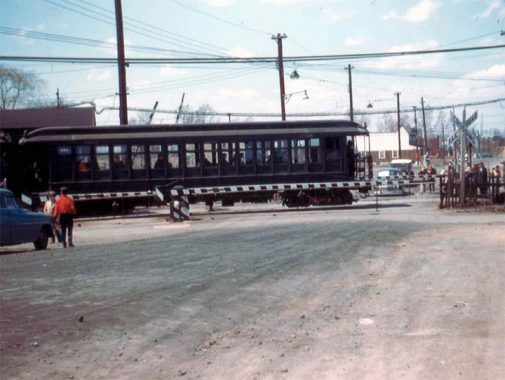
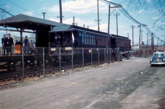
Finally NYC Subway’s Canarsie Line page shows a wealth of images of the East 105th Street station when it was a gate crossing. Here, a 1912 vintage open air gate car on a fan trip crosses East 105th in 1956. The page emphasizes subway car styles for train buffs but also “inadvertently” provides some glimpses of Turnbull Avenue…
In 1956, Turnbull Avenue, still a dirt road, passes alongside the station.
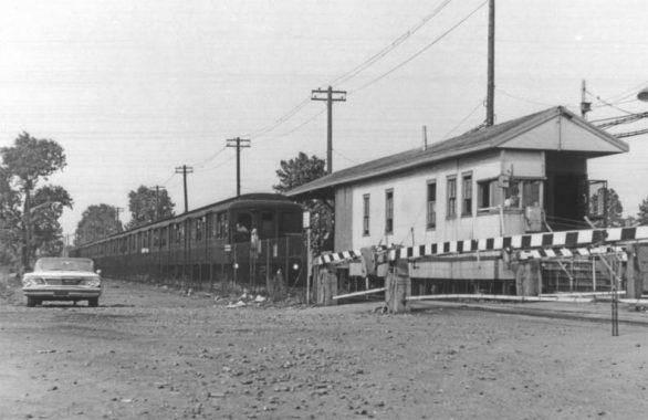
Turnbull Avenue can be seen here in 1966, at left as a dirt road, as was East 105th Street in the foreground.
Why “Turnbull” Avenue? It remains a mystery; I looked on this 1890 Kings County map excerpt for property owners with that name, with no luck. I imagine someone in the area was named Turnbull, or perhaps it was whoever cleared out the space along the tracks for the dirt road. I’m not sure Turnbull Avenue was ever paved, and it must have disappeared after a large station house was constructed at East 105th after the street was interrupted to traffic in 1973.
Today, I don’t know if any Canarsie residents remember a Turnbull Avenue at all.
Check out the ForgottenBook, take a look at the gift shop, and as always, “comment…as you see fit.”
10/2/20
18 comments
I knew where this was before even looking at the photo! I remember it being on NYCTA Subway Maps in 1964, 66, 68 and 69, the last two being studied for 100’s of hours! It was listed as the cross street for the E105 St station. Like you, I too studied maps of NYC growing up. I had gas station maps from all the different brands. Texaco, and later Mobil, Amoco and BP had the most complete street maps, but had no subways. I spent many hours adding the subway lines and stations to many of those maps. Many were the current map at the time. Others were Division maps. Others where just Manhattan El maps or Brooklyn El maps. I didn’t get my 1st Hagstrom map until 1970 or so; it was the highly detailed map of Lower Manhattan which even showed Subway Entrances. When I finally got my Hagstrom NYC Pocket Atlas, I finally got to see where the trains really went, e.g. the BMT just below DeKalb Av.
Thanks for the ride down “Remem-bery” Lane!!
Must be where the Turnbull ACs in “The Warriors” were from. (The skinhead gang with the school bus).
That scene was filmed by Broadway Junction but was supposed to be in the Bronx
My dad and two uncles worked for the railroad and I’ve heard that word before. Wiki says George Trumbull was a Scottish engineer who built India’s first railroad.
Map publishers sometimes introduce “errors” such as non existent streets to establish proof of plagiarism when
the error shows up in another publishers map.
The Canarsie Line station and grade crossing at East 105th Street was the last example of BMT grade level routes that were once common in Brooklyn before World War I. In particular, the four BMT routes that converge on Coney Island (Culver, Brighton, West End, and Sea Beach), collectively known as the BMT Southern Division, were originally all surface level lines, dating to their origins as steam-powered surface lines. After the initial conversion to electric power around 1900, these lines used overhead wires in lieu of third rail, because the grade-level street crossings remained intact. Those lines were rebuilt between 1907 and 1920, either in open cuts or on elevated structures, in order to eliminate the many street crossings and to allow use of newer steel subway cars that required third rail power collection. The Canarsie Line was similarly rebuilt and connected to the newer tunnel west of Broadway Junction.
The Long Island RR, which has many historical connections to the BMT’s predecessors, today still has many grade crossings in third rail territory in Nassau and Suffolk Counties, including six in my immediate neighborhood alone. The Little Neck Station is the only remaining LIRR grade crossing in NYC limits on a major LIRR route. There are also a few LIRR grade crossings just east of the Long Island City station, but that route only sees a few trains a day.
“R. Turnbull” is listed as General Manager in Brooklyn Daily Eagle ads for Vanderveer Crossings, a real estate development circa 1906 – 1907 in northern Canarsie. Prospective buyers were encouraged to take the “L” to East 105th Street Station, so Turnbull Avenue was probably originally intended as a street of some importance in the community.
To get to Gertz on the J train (which may have still been called the 15 train in 1968), you’d get off at the 160th Street stop, taken the easternmost stairs and walked east a block and a half.
This is good info and I just got you book. Amazing. I have a curious oddity that I myself have been researching to no avail. Why is Ralph Avenue in Brooklyn separated so far apart and I’ve seen in maps Rochester Avenue running perpendicular to Ralph past Remsen Avenue. Do you know why by chance???
Rochester Avenue south of ENY Ave was a rutted road in a vanished section called Pigtown. Its dirt roads and shacks were bulldozed decades ago.
Further research: Turnbull Avenue appears to have survived in some form into the 70s or 80s, as it is mentioned in articles in the Canarsie Courier. It would appear that industrial development of the area eliminated the necessity for Turnbull Avenue as well as a number of side streets. A surviving remnant appears to be an access road running behind the FedEx facility and leading from Stanley Avenue at E 108 St to the entrance of the Verizon facility on E 108.
From 1971 to 1973 I had the experience of taking the subway 5 days a week from Rockaway Parkway to 242 Street Van Cortland Park and back. It was LL BMT to A train IND to1 train IRT. Lived in Canarsie, going to school at Manhattan College. Remember well the grade level crossing at 105 Street and when it was eliminated. I used to walk along Turnbull Ave for exercise.
Not such a singular activity, Kevin. I collected Hagstroms too. A boy from NJ, I had to wait till high school days to go to “the city” to see what was really there compared to the map.
Whatever the Wikipedia entry for George Trumbull is isn’t relevant to this article. “T-R-U-M-B-U-L-L” is not the same person as “T-U-R-N-B-U-L-L”.
Turnbul Ave now contains the 3rd track which is use for yard moves. Trains comes
of the yards there to go to Rockaway Parkway.
I remember it from the circa 1960s transit maps as “East 105th Street – Turnbull Avenue. Growing up on East 15th Street in Homecrest, I thought it referred to our alopecia challenged neighbor, Jean Turnbull Londis. She was a loud mouthed, always cursing, balding beer swilling drunk who heralded from Nova Scotia. She always sported a HandiWipe on her head, in an attempt to cover her bald spot as The Phantom of the Opera would cover his face. One summer night while we were sitting in her front gate, she suddenly gave a shriek sending her beer can flying. She stood up on the highest step, pointing at the ground screaming, “LOOK! LOOK! A WORM! A WORM WITH A CONSTRUCTION WORKERS HAT!!!” We of course all went to look at what turnedout to be a worm with a Juicy Fruit inner foil wrapper stuck on its head. It took a while a to calm her down; all it took was another beer.
Bought my first Hagstrom in 67 so I could see what neighborhood the hippies were going to in the Summer of Love(East Village of course)
Always dug the fact that some of the street names that were really small were obviously drawn in by hand.Also got the feeling that I was looking at a map that was really old fashioned in a way.Hagstroms seemed to be from the 1920s not the modern 1960s.
Craziest map I ever saw was one of Midtown from the 1960s with almost every building drawn in 3-D.They must have used an aerial photograph then drawn over it.Fantastic detail!Must have taken a long time to make.American Airlines reproduced it in a travel guide of NY.But it wasnt made by Hagstrom but some other outfit
I remember using the East 105 Street Station to get around New York many times as a teenager living on Wortman Avenue in what was then East New York. (Early 1970s) I am still amazed that to this very day when you exit the L train at East 105 Street the exit signs still direct you to “East 105 Street and Turnbull Avenue,” despite the fact that you will not find a Street sign that says “Turnbull Avenue.”