

BY SERGEY KADINSKY
Forgotten NY correspondent
As a native of Bay Ridge who witnessed his neighborhood sliced by the highway and ramps of the Verrazzano-Narrows Bridge, Kevin Walsh has written extensively on the buildings that were lost and the trench that now separates Bay Ridge from the rest of Brooklyn. Less documented is the destruction on the other side of the bridge, where streets were broken into segments by the toll plaza and Staten Island Expressway. The official change of spelling in the bridge’s name in 2020 is gradually being implemented on highway signage, but there is one place where it will remain in stone, in honor of its namesake.

At the corner of Lily Pond Avenue and Major Avenue is a marble monument honoring explorer Giovanni da Verrazzano and engineer Othmar Ammann. Kevin passed by this sign last year but on my visit, I noted perhaps the oldest stone block on the island. Embedded in this monument are four blocks from the Castello di Verrazzano, located in Greve in Chianti in central Italy. The explorer’s descendants lived in this castle until 1819. Today it is the centerpiece of a scenic winery.
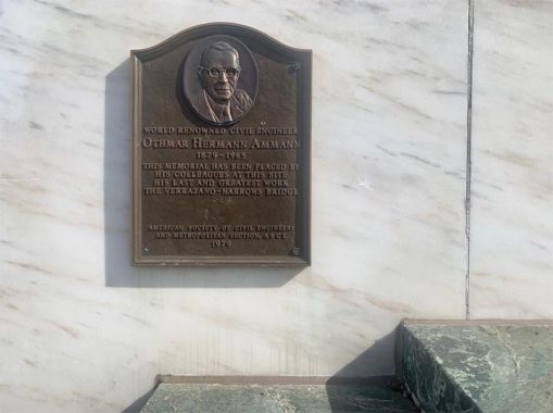
This monument has a plaque honoring engineer Othmar Ammann, who designed the Verrazzano Narrows Bridge but was not mentioned in Robert Moses’ speech when the bridge opened to the public. His works can be seen across the city: Bronx-Whitestone, George Washington and Bayonne Bridges, are among the top examples.

A largest plaque on this monument shows a map of the region between Boston and Philadelphia with the colonial-period roads connecting these old cities. At the time of the American Revolution, couriers had to take ferries across the Hudson and Delaware rivers. The caption notes that this bridge is the “final link in the Metropolitan arterial System affording Through Highway Travel to the South and West.” But I am not sure how many motorists traveling between New England and the South use the Verrazzano Bridge. Seems that most of the traffic passing through NYC takes the highly congested Cross-Bronx Expressway and the George Washington Bridge.

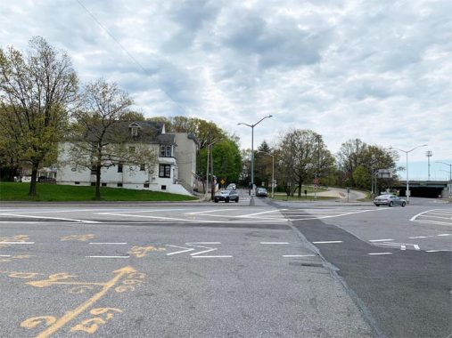
Major Avenue at Lily Pond Avenue is co-named for Officer Thomas Choi, 62, a Staten Island resident who was killed by a speeding driver while removing traffic barrels to reopen the lower level of the Brooklyn-bound side of the bridge in October 2013. He was in a coma for 14 months before dying of his injuries. Choi was the first MTA Bridge and Tunnel Officer to die in the line of duty in the 81-year history of the Triborough Bridge and Tunnel Authority. One block to the west of this monument is a one-block segment of Tompkins Avenue, named after Daniel Tompkins, the fourth governor of this state, sixth Vice President of this nation, and developer of the Tompkinsville neighborhood.
I
I
I
I
I
I
I
On the north side of the bridge approach is another segment of Tompkins Avenue, branching off Lily Pond Avenue. Only four houses have addresses on this dead-end.
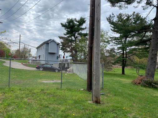
Across Lily Pond Avenue is the longest segment of Tompkins Avenue, rising on a slope next to an empty lot, the house at 872 Tompkins Avenue has an unusual shape on account of the property line here. The empty lot us the right-of-way of the South Beach Branch of the Staten Island Railway, which was abandoned in 1953. Kevin followed the path of this line is 2009, finding orphaned trestles and alleys that run on the route of the tracks.

Bit by bit, the empty lots where the trains ran are filling up with houses and most of the trestles have been removed. Perhaps there’s a remote chance of the North Shore Branch seeing trains again in the future, but with so much development on its route, the South Shore Branch is gone for good. For urban explorers, Tompkins Avenue has a bridge running across the branch, and I had the opportunity to look into it. The northern portal to this underpass was filled in 1997 when houses were built on top of it.

A private street, Bridge Court with its couple dozen homes stand on the route of the train line. Further north, Wilton Court, Cabot Place, Hope Lane, Deal Court, and Vermont Avenue also follow the route of the South Shore Branch. Tompkins Avenue has its start a mile and a half north of here at Staten Island’s Canal Street.

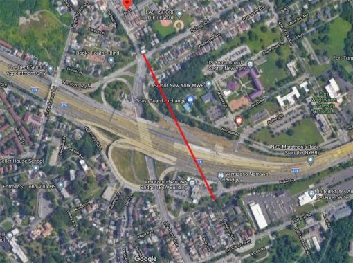
As with many of my photo essays, historical maps and aerials tell the story of a street’s transformation. On this 1951 aerial survey from DoITT, we see Tompkins Avenue running unobstructed through Arrochar and Rosebank. The yellow line approximates the path of the Staten Island Expressway that will slice across these neighborhoods in the early 1960s.
Lily Pond Avenue replaced Tompkins Avenue as the main north-south road in this area. Its name prompted me to search for a namesake waterway, but it is a relatively new road. It does not appear on a 1917 map of the borough. It appears on the 1963 Herrmann Bollman map, in time for the opening of the bridge.
Here on this 2020 aerial view, Tompkins Avenue’s former route is marked in red.

The New York Public Library collection of Staten Island postcards has an undated one indicating Lily Pond in Rosebank, but none of the historical maps have Lily Pond Avenue on it.

The 1906 topographical survey of Staten Island shows numerous kettle ponds near Tompkins Avenue. Perhaps one of them is the namesake of Lily Pond Avenue. This search is reminiscent of one that I conducted for Fresh Pond Avenue in Queens, which was also named for a long-forgotten pond. (Once again, Tompkins Avenue is marked in red.)
Sergey Kadinsky is the author of Hidden Waters of New York City: A History and Guide to 101 Forgotten Lakes, Ponds, Creeks, and Streams in the Five Boroughs (2016, Countryman Press) and the webmaster of Hidden Waters Blog.
As always, “comment…as you see fit.” I earn a small payment when you click on any ad on the site.
6/3/21
6 comments
From the looks of it, Lily Pond Ave was created along the ROW of the old Staten Island Rapid Transit South Beach line, which makes sense since it was abandoned only a few years before bridge construction began.
Wonder what those folks who lived on that rump end of Tompkins Ave near the toll plaza must have thought, seeing their block transform in a decade from a sleepy little road alongside a little-used railway line into a
feeder for the longest suspension bridge in the world. Also, I could never figure out where nearby School Road got its name, as there is no school within shooting distance of the road, which doesn’t even show up on
maps until the early 20th Century.
I think it’s NE of the ROW.
Actually, if you look at aerial views from 1951 and today, the portion of Lily Pond Ave that runs underneath the toll plaza overlays the exact route of the abandoned SIRT. Makes sense since not a lot of grading would be needed as the ROW already existed.
How many of the other Tompkins in NYC are named for this Tompkins?
I lived on Staten Island in the 1950’s and both the SIRT was there and Lily Pond Avenue,
Staten Island was like upstate NY back then, beautiful with lots of things to do and lots of things to see.
I remember going to Cosmos on Hyland Blvd. Santa Claus would arrive by helicopter, which didn’t make any sense to me.
I loved the drive-in, all the movie theaters. Going to South Beach (I used to live there back then). Also, going to see the tulip nursery that was located somewhere on Stateen Island, I don’t know where, because Dad was driving the car.
I loved going to Stapleton. It had so many nice stores back then. I went back there in the 1990’s and was happy to see that the bank is still there, Woolworth’s was still there minus the wooden floors. It was very sad to see that most of the stores were gone, replaced by a mall? It was much nicer the other way. For the parents and the children.
It was a joy to ride the Staten Island Ferry again. To see St. George again was a joy.
The bus route that goes through South Beach had changed a lot. Yet, I did get to see for the last time in my life the rides, I wished my brother had been there, he rode on those rides too.
I lived at 875 Tompkins avenue on the rise between Wadsworth Avenue and Fingerboard Road. Loved it back then. We would walk to the RR overpass near the old coal yard and pick coal that had fallen from the Train chutes onto the tracks. We would bring it home with wagons and/or sleds. We heated the house with coal and there was also a coal stove in the kitchen right up until we moved in 1961.