

AFTER reaching Richmond Avenue by walking Forest Avenue west from Silver Lake Park in November 2021 my day was not yet done. My plan was to then head for Richmond Terrace to catch the S40 bus back to the ferry. The most interesting route to take for this initiative would be to use the main business street in the area which would be Port Richmond Avenue. However, I had done that already and indeed, visit Port Richmond rather frequently as Staten Island neighborhoods go. I have walked Castleton, Port Richmond and Jewett Aenues, and now Forest. But “out there,” since my visits are limited to a handful of times per year, I have yet to cover every square yard and surprises can come up. What did I do? I’ll say later.
By the time I had reached Egbert Square, where Forest Avenue, Port Richmond Avenue and Willowbrook Road come together, it was 3 PM and normally that’s the brightest time of day. Not in November, though, and I knew I would be roaming in the gloaming soon enough. I fortified with a slice at Brothers Pizza (for lunch I limit myself to one slice).
I am a kind of reverse vampire. I am not a sophisticated enough photographer, unlike my pal Mitch Waxman at Newtown Pentacle, to be able to buy cameras suitable for night photography or know what settings to adjust on my modest Panasonic Lumix to shoot in the dark. Thus, I tend to be active during the day, completely diurnally. And to think I worked overnights in a variety of jobs over the years (the latest was a couple of months in 2018 in the same building in which I had an overnight print job from 1982-88!) In youth I did involve myself in some nightlife, too, which has ended and I don’t miss hanging around the West 4th Street station in the Village at 3 AM watching it spin around me, either. The daytime is for me.
Photos in batch: 63
Date of photography: November 20, 2021
Jut south and west of Port Richmond, Graniteville is a Staten Island neighborhood now neatly defined by four routes: Willowbrook (Martin Luther King) Expressway, Forest Avenue, the Staten Island Expressway and South Avenue. The name comes from the many rock quarries in the region in the 1800s: however, granite was never quarried there! The rock acquired at the quarries was sodium feldspar, while granite is actually potassium feldspar. Much of Graniteville is residential or occupied by the large Baron Hirsch Cemetery which is bordered by the smaller Heart of Jesus Cemetery and the cemetery that was one of my destinations on this walk, Lake Cemetery or Lake-Silvie Cemetery (the two are listed both as one and separately).
GOOGLE MAPS: GRANITEVILLE-PORT RICHMOND
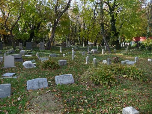
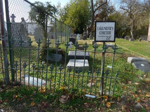
Lake Cemetery, established by Joseph Lake in 1834, and Silvie Cemetery, established about 60 years later, were combined several decades ago with the Lake portion bordering Willowbrook Road and the Silvie section toward the rear, facing Forest Avenue. When I first encountered it in the 1990s, it was overgrown and weedy and indeed used as a dumping ground, but the Friends of Abandoned Cemeteries have done a decent cleaning and maintaining it and erected the distinctive blue and white signs seen elsewhere around the island. Lake Cemetery saw its most recent burial in 2003.

Adjacent to Lake Cemetery at #36 Willowbrook Road is the former Graniteville Methodist Church, now Iglesia Pentacostal Rehoboth. The Municipal Archives has a 1940 photo and you can see how much of the ornamentation as well as the bell tower have been stripped off in recent decades.
Though Lake/Silvie is relatively clean and weed free that’s not to say that there aren’t a lot of toppled headstones, whether from weathering and age or the actions of area miscreants.

Members of the Lake and Silvie families are interred side by side. I.A. Silvie, an undertaker and cabinetmaker, purchased some of the Lake property, which included some of the cemetery, in the 1890s. The Meislohn-Silvie Funeral Home was located in Port Richmond for many years.
According to the NYC Historic Districts Council, Lake/Silvie is the final resting place of hundreds of veterans from the Civil War through World War II. Among these are several African American veterans, including members of the Buffalo Soldiers, who were the first African Americans to enter France during World War I.


A look at Lake-Sylvie. Many of Staten Island’s abandoned or at risk cemeteries are behind locked fences, but for now, it remains open to the public.

Emeline Long-Earl (1835-1926) enlisted as a nurse in the United States Army in 1861 and was the only woman in Staten Island to serve in the Civil War. Her son Henry Bailey Earl was born the same year she joined the Army. She was wounded during the war and recuperated in Kings Point Hospital on Long Island. She later spent the last two decades of her life. at the now abandoned Kings Park Psychiatric Center. When Mrs. Earl was interred in Lake Cemetery she was given full military honors.
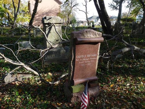
Calvin Van Name (1857-1924) was born in Mariners Harbor, son of oyster “planter” William Henry Van Name. A Van Name Avenue in the neighborhood remembers the family. Van Name, a lawyer by trade, later won a seat in the NYS Assembly from Staten Island, was appointed borough president in 2015 and won election in 2017, serving until 1921.
The name “Decker” is ever present in Staten Island cemeteries. The name does not sound Dutch but the first Decker in Staten Island was Johannes de Decker who arrived in 1655. The Decker family was indeed fruitful and multiplied and there are still numerous Deckers on the island. Marjorie Decker Johnson was one of Staten Island’s noted historians.
One of the Decker farms in what is now Heartland Village, at 435 Richmond Hill Road, is one of New York City’s two farm museums (the other being the Queens Farm Museum in Glen Oaks). On Decker’s 20 acres, immigrant farmers are trained to grow native crops in NYC’s northern climate as part of the New Farmer Development Program.
The Decker Farm is open to the public: visitors can learn about farm life with hands-on activities such as rug beating, hay raking and apple and pumpkin picking in the fall. For hours, call Historic Richmondtown at 718- 351-1611, ext. 280.
The acreage has been used as a farm since 1809. The farmhouse, owned and operated by the Staten Island Preservation Society, was built by Japhet and Sarah Alston that year; the property was sold to Lorenzo Decker in 1841, and the Decker family farmed and lived here until 1955, when Alberta Decker donated the property to the Staten Island Historical Society.
Both the Long-Earl and Van Name headstones are new, replacing the originals that had fallen into illegibility or disrepair.


A second look at Lake-Silvie Cemetery.


The aforementioned Egbert Square is named for a local WWI casualty, Arthur S. Egbert, who was aboard the troop transport vessel USS Abraham Lincoln when it was sunk by a German U-boat after its escort of destroyers had left. Earlier, the Navy had seized what was originally a German vessel named the President Lincoln of the Hamburg-American shipping line, constructed in Belfast in 1907.


Having decided to evade Port Richmond Avenue on this trip I used Decker Avenue one block to the east. Given all the Deckers who have been and still are on staten Island I was surprised that this is the only street with the name. It was a pleasant walk with just-past peak fall colors which now occur on Staten Island in late November and pleasant housing stock.

The combined congregations of St. Paul’s and St. Luke’s Churches meet at this handsome church building completed in 1911 at Decker Avenue and Catherine Street. St. Lukes was founded in 1905 and St. Paul’s, the oldest of the two, in 1889. With declining attendance St. Paul’s sold its church in 1971 and moved in with St. Luke’s.

I will probably never know the story behind the initials P.L.C.K.S at the San Miguel Deli at the north end of Decker Avenue at Post.
This is the south end of Washington Place, which comes to a dead end just before reaching Post Avenue, inexplicably enough.
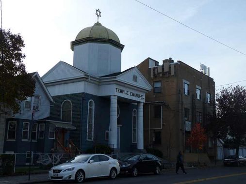
The domed Temple Emanu-El, 984 Post Avenue east of Heberton, was completed in 1907 [Henry Pelcher, arch.] with its design partially based on the Great Synagogue of Warsaw, Poland. The temple’s now-disused school, an Art Deco building completed in 1928, stands next door with a “space available” sign.


The original Grace Methodist Episcopal Church was constructed at Heberton and Castleton Avenues in 1867, but burned down approximately 20 years later. This Gothic revival building was erected in 1895, with the name of the church the date of construction inscribed prominently below the steeple on the corners, a feature found on no other churches around town as far as I know. Like many other Port Richmond buildings it was designed by local architect James Whitford.

Holding down the corner at 233 Heberton across from the church on Castleton is this 1860s villa in an Italianate style. It was constructed in the 1860s, with a prominent Port Richmond doctor, T.D. Lyon, in residence in the 1870s. Owner Steve Ruggirello, a former firefighter, has decorated the front lawn with maritime artifacts and a 9/11/01 tribute.


More of Heberton Avenue’s prominent residences. The stretch of Heberton Avenue between Ann Street and Post Avenue rivals St. Mark’s Place in St. George, Wards Hill and St. Paul’s Avenue in Stapleton for the variety and beauty of the dwellings you will find there. Side streets such as Anderson Avenue and Cottage Place also warrant investigation if you enjoy premier residential architecture.


This Romanesque Revival building , the Northfield Township District School 6 and later PS 20 at 160 Heberton Avenue at New Street, with its distinctive clock tower, was built in 1891 with an 1898 addition. It “may be considered the most elaborately ornamented school ever constructed on Staten Island” according to the Preservation League of Staten Island. Look for the carved cherub heads on keystones above the windows. The school became low-income senior housing in 1994; the conversion revitalized the building.
Northfield is one of the former Staten Island towns that was eliminated when Staten Island became a borough of Greater New York on 1898.


Port Richmond has its very own town square, Veterans Park, which shows up on the 1873 map and is still here, between Park and Heberton Avenues and Bennett and Vreeland Streets. Arrayed around it are several choice samples of Port Richmond architecture. In fact this is Staten Island’s oldest park and has been here since 1836 when the majority of Port Richmond’s streets were platted. It was renamed in honor of American veterans in 1949. In 1930 the Daughters of the American Revolution dedicated a stone monument on the Park Avenue side to participants in Sullivan’s Attack of August 22, 1777, when American Revolutionary War officer and political leader John Sullivan led an unsuccessful night attack on Staten Island (according to NYC Parks; most American initiatives in NYC an environs in the Revolutionary War ended in defeat or strategic defeat, but we prevailed anyway). The marker got a new plaque in 1998 when the DAR rededicated it.
On the other side of the park, at Heberton and Vreeland, is a decorative drinking fountain dedicated in 1915 to Eugene G. Putnam (1865-1913), a longtime principal of PS 20.


An element of the Port Richmond streetscape not necessarily found elsewhere in Staten Island is the presence of apartment buildings. Here are two at Park Avenue and Ann Street and a very large one at Heberton Avenue and Vreeland Street. In NYC, apartment buildings are usually found near mass transit hubs. But Port Richmond has no mass transit save buses.
Once it did, though, as Staten Island Rapid Transit served it on its North Shore Branch until 1953 (see below).

In November, #121 Heberton at Bennett was already bedecked for Christmas. This residence, constructed by carpenter-builder James G. Burger around 1859-61, is a rare surviving example in New York City of a picturesque villa in Rustic style. Notable features include the handsome bracketed door and window surrounds and the cross-gabled roof with overhanging eaves enriched with unusual braces. soon after its completion, this house passed to Captain John J. Housman,a prosperous oysterman and noted abolitionist. The house was leased to tenants until 1892 when it was acquired by Robert Brown, the owner of a neighboring saloon who held a number of offices in the Port Richmond government. The house remained in the ownership of the Brown family until the 1940s. info: nyc.gov
In 1901, the Scottish philanthopist/industrialist’s organization, the Andrew Carnegie Foundation, gave $5.2 million to New York City for its libraries across the five boroughs. This started a remarkable project that would go on to build 1,680 Carnegie libraries across the United States and another 800 plus in Canada, the United Kingdom, and elsewhere in the world.
Carnegie paid for the buildings, but the city would have to buy or acquire the land, buy the books, and provide for maintenance and upkeep, in perpetuity. Carnegie helped set up the library commissions and boards.
67 such libraries were constructed in NYC over the 20th Century’s first three decades. Of those, eight have been razed. I’d like to visit the remaining 59 and chronicle this remarkable project that adds to New York city’s richness of historic architecture.
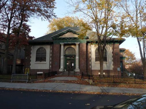
Four Carnegie Libraries were built on Staten Island in St. George, Stapleton, Port Richmond and Tottenville. This one on Bennett Street and Heberton Avenue facing Veterans Park, which functions as Port Richmond’s town square, was constructed in 1905 in a Classical Revival style by architects John Carrere and Thomas Hastings, the architects behind all four of Staten Island’s Carnegie Libraries, Staten Island’s Borough Hall, and the main branch of the New York Public Library on 5th Avenue and West 42nd Street. John Carrere was a part-time Staten Islander, maintaining an home and office at St. Marks and Fort Places in St. George.


The St. Philip’s Baptist Church on Bennett Street next door to the library was organized in 1870 as a mission and met in local residences before finding a home at the Park Baptist Church in 1880; four years later, it acquired land on Faber Street and built its own church in 1889, incorporating as St. Philip’s in 1890. When the congregation outgrew the Faber Street church, it purchased this neo-Gothic church built in 1891. Longtime pastor Rev. Dr. William A. Epps, Jr., who served from 1954 to 1992, is honored with a street sign on Park Avenue.
The Mar Thoma Church of Staten Island, serving Syrian Christians based in the Indian state of Kerala (it’s complicated!) now occupies the 134 Faber Street site.
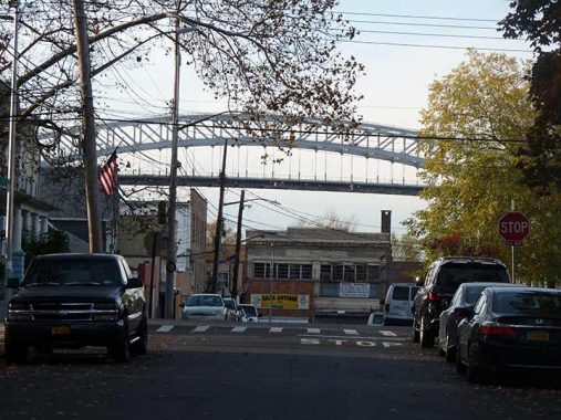
Glancing west from several vantage points in Port Richmond vouchsafes a look at the Bayonne Bridge. Four auto traffic bridges connect Staten Island to the outside world. In order of construction, they are the Outerbridge Crossing (named for its engineer, not because it is in the outer reaches of NYC) the first Goethals Bridge (opened the same day as the Outerbridge, 6/29/28), the Bayonne Bridge (11/15/31), and the Verrazzano-Narrows Bridge (11/21/64). The original Goethals was replaced by two cable-stayed bridges, known collectively as the Goethals Bridge, opening in 2017 and 2018. Maybe this will be the year I walk the new Goethals!
I crossed the Bayonne on foot in 2012. Since I did that, the bridge looks a little different. The roadbed was raised to allow tall masted ships safer clearance and at the same time, this necessitated a completely new roadbed and pedestrian accommodations. Perhaps I’ll walk across the reconstructed Bayonne this year too.


Still thriving between St. George and Tottenville, the Staten Island Railway, a subway in everything but name that extends from St. George Ferry to Tottenville, was once much more extensive. Formerly known as Staten Island Rapid Transit, the Staten Island Railway was begun by Cornelius Vanderbilt in 1851 for the purposes of linking Vanderbilt’s Landing in Stapleton to Clifton. By 1860, the line was extended to Eltingville, then on to Annadale, and finally to Tottenville. In 1883, Erastus Wiman, in partnership with the Baltimore & Ohio Railroad, built a line to South Beach and along the North Shore. By 1885, what would become the SIRT was complete, with the completion of the tunnel between Stapleton and the St. George Ferry.
By 1953, ridership had dropped to such a degree (due to reduced bus fares) that the B&O threatened to terminate all passenger service. The City agreed to subsidize service on the Tottenville line and terminate service on the North Shore and South Beach branches. The B&O ended its involvement with Staten Island Rapid Transit in 1971, selling it to NYC for $3.5 million. Quaint B&O passenger coaches that had operated on the line since 1925 were replaced by modern R-44 subway cars (after MP Long Island Rail Road cars filled the bill for a time). Finally, the MTA changed the name of the SIRT in 1994, renaming it the Staten Island Railway.
In Port Richmond and along the island’s north shore, ample traces of the old line are still remaining, including two intact elevated stations at Port Richmond (Port Richmond Avenue) and Tower Hill (Sharpe Avenue and Grove Street).
Can North Shore service ever be reactivated?


The Dutch Reformed Church at Port Richmond Avenue and Church Street was erected in 1845, replacing two earlier structures, but its congregation is much older. This was the original settlement of what became Port Richmond in the 1660s and is the oldest religious congregation on the island. The churchyard commands the most attention, since it contains dozens of stones dating back to the early 1700s that have weathered well, unlike the ones from the 1800s cut from marble. An many you will find names that appear on Staten Island street maps.
For a closer look at this piece of history from nearly 360 years ago, see an earlier FNY page in Port Richmond.


Port Richmond Avenue near Richmond Terrace features a number of ancient buildings that have exterior notations on the architect and date of construction. About a decade ago, faithful reproductions of early 20th Century ads appeared on the street from production work done for the TV show Boardwalk Empire. Most of these have vanished by now.

This lengthy brick building on the east side of Port Richmond Avenue between Richmond Terrace and Church Street was built in 1874 for Charles Griffith, a boot and shoe dealer. Directly abutting it on Richmond Terrace until 1945 was an 18th Century private residence known to be the last home of Aaron Burr, the third Vice President; that building was demolished in 1945.
‘Cause when love is gone, there’s always justice
And when justice is gone, there’s always force
And when force is gone, there’s always Mom. –Laurie Anderson, “O Superman”
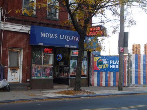
And there’s always Mom’s Liquors, on Richmond Terrace, one of the few businesses in the immediate area still going strong. As is its 1940s-vintage sidewalk sign. Its red neon still lights up, even during the day. NY Neon claims it for 1935.
As always, “comment…as you see fit.” I earn a small payment when you click on any ad on the site.
2/27/22
7 comments
So, south of the SIE would be considered Bulls Head? How about Richmond Ave @ Victory? Thanks
Great name for a liquor store but my favorite is High Spirits on northern blvd.
Speaking of Staten Island vampires:
https://www.bing.com/videos/search?q=what+we+do+in+the+shadows+tv+show&docid=608034659144920271&mid=FE3449829BA55DCDA144FE3449829BA55DCDA144&view=detail&FORM=VIRE
Check out Collin; he’s an energy vampire & therefore not nocturnal. Some would say that you could be mistaken for an energy vampire (but not I)
Kevin, most of these photos have terrific lighting that you don’t need to apologize for.
The letters in San Miguel P.L.C.K.S. are making me crazy. I don’t know Spanish so I can’t even guess. And no A for Angel.
“Decker” would be more “Dutch” if it were spelled “Dekker,” like the actor Albert Dekker. It means “thatcher.” My suspicion is that the spelling got Anglicized along the way., maybe even as early as 1664.
Love this stuff! I attended IS 51 in the late 1970s and often cut through Lake Cemetery, which was MUCH more creepier then, before they cleaned the plot up. I’m descended from the Decker family on my step-grandfather’s side (well, maybe descended in a figurative way) and spent many an hour roaming the streets of Decker Ave, Graniteville and Port Richmond. And that liquor store has been in Port Richmond Square as least as far back as the 1960s, maybe even earlier. I spent many an hour waiting for the S1 (now the S40) Richmond Terrace bus coming home from my newspaper job at 1am. Let me tell you, that area was LONELY and creepy at night, even back in the 1980s. Don’t miss that commute!
Fabulous