

I hadn’t thought of mentioning them before, but New York City streets feature states’ names. Not in concentrated blocs, like signers of the Declaration of Independence (Brooklyn), vestrymen of Trinity Church (Manhattan) New York City mayors (Bronx) or classical composers and astronauts (Staten Island). The Bronx even once had a clump of streets named for important pressmen of the past.
New York City’s “state streets” are scattered around for the most part, while in some regions they are found in loose groupings. I have no idea why, in most cases, a particular state was so honored; perhaps a developer wished to honor his home state. Some of these will surprise you, no question.
Obviously, it would be a pain in the neck and time consuming to get pictures of all the state streets on my own, and I depended on Google Street View for them and I’m not removing any identifying markings. I tried to find compelling scenes but in some cases that was difficult indeed!
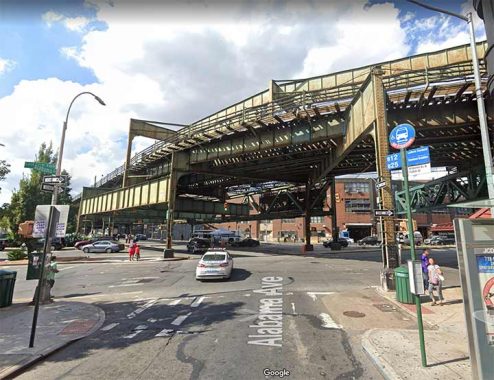
Alabama Avenue, East New York
Though Dutch immigrants had established some homes and farms in Brownsville and East New York in the 1700s, the area did not gel as a community until the early-to-middle 1800s. East New York was developed by John R. Pitkin, a Connecticut merchant beginning in 1835, while Brownsville is named for Charles S. Brown, who subdivided it in 1865. By 1890 its street arrangement and names had been settled on for the most part.
What you notice are two separate sections of “state streets:” one with southern states, Alabama, Georgia, Louisiana, and another with northeast states, which I’ll touch on later. Why were they so named? Who knows?
Here we see the north end of Alabama Avenue at Fulton Street, where the Broadway el (the J train) makes a turn from Broadway onto Fulton. The line connects Broad Street in Manhattan with Parsons-Archer in Jamaica.
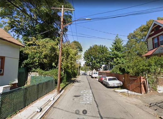
Alaska Street, West Brighton
It’s a mystery to me why there’s an Alaska Street in West Brighton, running from Richmond Terrace south to Castleton Avenue. The clump of trees on the left are in an abandoned cemetery called, naturally, Staten Island Cemetery.
This isn’t the sole reference to Alaska or the Great North on the Staten Island map. In New Springville, near Staten Island Mall, a group of streets are named Klondike, Nome, Platinum and Yukon.
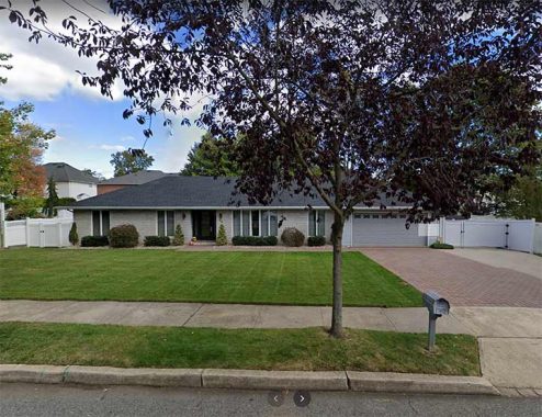
Arkansas Avenue, Great Kills
Arkansas Avenue is a one-block street running between Elverton Avenue and Gifford Lane, a block south of busy Barlow Avenue.

Arkansas Drive, Mill Basin
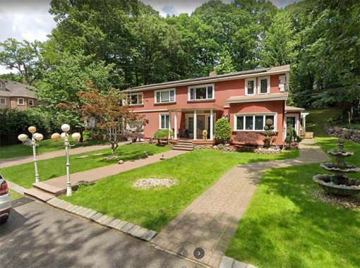
Mill Basin is way out there by Brooklyn standards, just northeast of Kings Plaza but on a peninsula defined by the waterways Mill Basin and East Mill Basin, and accessible from Avenue U only by East 63rd through 66th Street and by Mill Avenue. The streets are laid out in strict semicircles, the only NYC neighborhood other than Rego Park in Queens to do so. Some of NYC’s most luxurious and yet eclectic homes can be found in Mill Basin, such as the residence above at Arkansas Drive and Bassett Avenue.


Dakota Place, Kansas Place, Montana Place, Ohio Walk, Utah Walk
How Mill Basin got its states’ names, I know not, other than perhaps a burst of patriotism by its original 1950s developers; another of its streets is National Drive. Oddly, another of its roads is 56th Drive (not East 56th Street, which would be logical). I haven’t been in Mill Basin in decades! it’s hard to get at, with no subway, and only the B3 and B100 buses going there. Most of my forays were on a bicycle in the 1980s and 1990s.
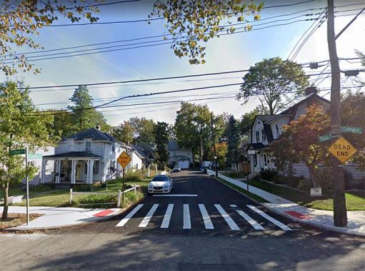
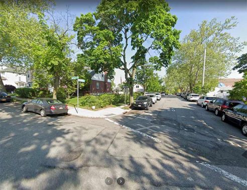
Carolina Place, Westerleigh
Carolina Place is a dead end on College Avenue in Westerleigh (see Maine Avenue below). There are no North or South Carolina (or North or South Dakota) streets in NYC, so I’m letting Carolina and Dakota stand for them.


Carolina Road, Maryland Road, Douglaston
This pair of pleasant state streets in Douglaston can be found between Hanford Street and Douglaston Parkway south of Rushmore Avenue. If developers intended any more state streets here, they didn’t follow through on it.
In addition, there are a pair of short courts, Carolina Court and Vermont Court, between Suffolk Avenue and Gansevoort Boulevard either side of Harold Street in Willowbrook. Nice enough, but nondescript.

Colorado Street, Westerleigh
This is another very short street in Westerleigh…so short that Hagstrom included it in its street index but did not show it on its base map. It runs one block from College Avenue to Kingsley Avenue. Once again I’ll discuss Westerleigh at further length at Maine Avenue, below.
Connecticut Street, Tottenville
Staten Island seems to have a number of neighborhoods with state streets here and there, but not really following through on the concept. For example, Tottenville has both a Connecticut and a Massachusetts Street but no other New England streets. Connecticut Street is pleasant enough but nothing to write home to Mother about.
I like ranch houses…no stairs…so here’s a nice one on Connecticut Street.
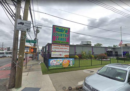
Delaware Avenue, Dongan Hills
Unlike other state streets in Staten Island, Delaware Avenue stands alone in Dongan Hills, with no other state streets accompanying it. Pictured is Delaware Avenue at Hylan Boulevard, where we find Rab’s Country Lanes, here for over a quarter century. Owner Rab Wilkinson, who passed in 2008 and a pro bowler himself, helped local organizations raise over $500,000 through fundraisers and events, and was rewarded with a street corner named for him.
Delaware Avenue, Flushing
Though Flushing is known for its “plant streets” from Ash to Rose that commemorate the area’s former plant nurseries, the pattern has its exceptions and Delaware Avenue is one, sotted in between Cherry and Elm (further west, at the Queens Botanical Garden, the D street is Dahlia Avenue). I’m quite familiar with Delaware Avenue, as I lived in the area from 1993 to 2007.

Florida Avenue, Arrochar
Both Staten Island’s Florida streets are short. Florida Avenue is a pleasant residential street running one block between Major and McClean Avenues a block west of main drag Lily Pond Avenue.
Florida Terrace, Richmondtown
Rockland Avenue is a very busy auto route (walking or bicycling it isn’t recommended as it has no sidewalks or shoulders) connecting Richmondtown and New Springville, snaking through Latourette Park. It has several dead end tributaries, such as Florida Terrace, which runs as a rutted path through a thick forest before it reaches a pair of huge mansions, one of which is shown here.
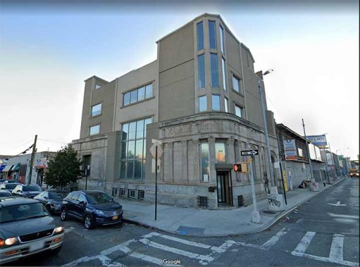
Georgia Avenue, East New York
This defunct bank, on Atlantic and Georgia Avenues in East New York, was built before consolidation in 1898, and so reflected that this was the local bank of the 26th Ward. New York City used to have political designations called wards, which were the smallest political units in NYC. Each ward elected an alderman and an assistant alderman to the City Council. According to The Encyclopedia Of New York City (1995, Yale University Press) the system goes all the way back to 1686, when Governor Thomas Dongan divided the city, then entirely in Manhattan, into six wards. In 1791, wards were given numerical designations. The First Ward was the tip of Manhattan, and districts were given consecutive numbers the further north you went in Manhattan. New wards were added as the city expanded northward, and increasing population of the older wards required subdivision. Brooklyn was also composed of wards. When it became a city in 1837, it was divided into nine wards, and by the time of consolidation with NYC in 1898 it had 32 wards.
This former bank is one of the last tangible remnants of the old ward system. In 1999 I got some photos before a new building was kerplunked on top of it: fortunately, the old building was retained.
Georgia Road, Flushing
This is another exception in the “plant streets” of Flushing; further west, the G street is Geranium Avenue. The building at left hosts a urologist, where I had a rather painful checkup in 2002.

Idaho Avenue, Pleasant Plains
Idaho Avenue is L-shaped, running at a 90-degree angle between main drags Amboy and Bloomingdale Rads. You will find several megamansions in the area, like the one pictured.
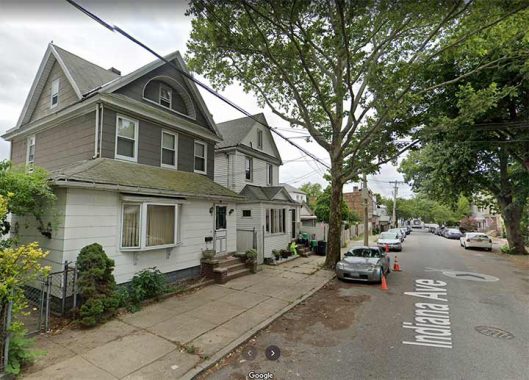
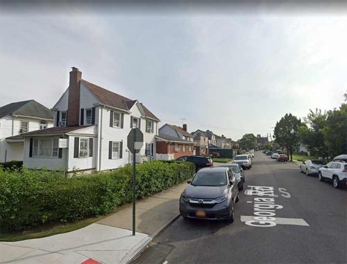
Indiana Avenue, Glendale
Glendale seems to have more than its share of streets that the Queens Topographical Bureau overlooked when it set about numbering all of Queens’ streets in the 1910s, as there are quite a number of named streets left over. Indiana Avenue might just as well have been renamed 79th Avenue, since that seems to be the correspondent number in these parts. I’m glad it didn’t get numbered. It’s a dead end on 72nd Street south of Myrtle Avenue and bordering Cypress Hills Cemetery.
At one time the city had plans to extend it but those plans didn’t materialize.
Louisiana Avenue, East New York
Another of East New York’s southern strategy state streets, Louisiana Avenue begins further south than the others, running from Williams Avenue at the Lambert Chapel past the Breukelen Houses and the Spring Creek Nature Preserve.
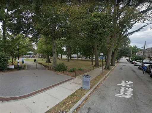
Maine Avenue, Westerleigh


In central Staten Island there’s a place whose original residents were dedicated to stamping out demon liquor years before the Volstead Act actually did the deed from 1919 to 1933. Developed in 1887 by Christopher S. Williams and William H. Boole, who purchased acreage from John vanderbilt and created a summer retreat known as the National Prohibition Campground Association, what’s now Westerleigh was known as Prohibition Park and was lined with narrow, brick streets and one-family houses, some of them in ornate Victorian style. Most of the streets in Westerleigh are named for Presidential /Vice Presidential candidates of the Prohibition Party, such as Neal Dow (1880) John St. John (1884), Clinton B. Fisk (1888), John Bidwell (1892) and John Woolley (1900). “Dry” states in the 19th Century such as Maine, Ohio, New York, Colorado and Delaware are also featured on the Westerleigh map. The neighborhood takes its present name from the Westerleigh Collegiate Institute, formed in 1895; the institute was the first in Staten Island to provide an education from kindergarten to the collegiate level. College Avenue was named for it.
A walk through Westerleigh will reward you with sightings of the very best of classic late 19th Century residential architecture.
Maryland and Vermont Avenues, Rosebank
Two for the price of one, as the only case of two state streets intersecting is here in Rosebank.
Rosebank is a pleasant village in southeast Staten Island with tree-lined streets filled with venerable old homes that are gradually giving way to new construction, especially along the old right-of-way of the South Shore Branch of the old Staten Island Rapid Transit. Beautiful views of the Narrows, the Verrazano-Narrows Bridge, and Bay Ridge, Brooklyn, can be glimpsed from Alice Austen and Arthur Von Briesen Parks. Rosebank is anchored by the campanile of St. Mary’s Roman Catholic Church, built in 1857 at 1101 Bay Street at St. Mary’s Avenue, and the slim spire of St. John’s Episcopal Church built in 1871 at 1331 Bay opposite Belair Road. Rosebank, primarily an Italian neighborhood in the early 21st Century, has been home to pioneering photographer Alice Austen and Italian unifier Giuseppe Garibaldi.
it also has its share of state streets, including Maryland, Virginia and Vermont Avenues. Not only that, Pennsylvania Avenue was subsumed into Hylan Boulevard and New York Avenue became Bay Street.

Massachusetts Street, Tottenville
The second of Tottenville’s New England state streets, Massachusetts Street borders Conference House Park, where a. 17th Century home built by the Billopp Family hosted a peace conference with British general to stave off a war, unsuccessfully.
A brick mansion built by British Royal Navy Captain Christopher Billopp at about 1680 (the date changes depending on the source) at the end of what would be Hylan Boulevard was almost a century old on September 11, 1776 when Benjamin Franklin, John Adams, and Edward Rutledge met here with Admiral Lord Richard Howe, representing King George III, in an attempt to end any future hostilities. While Howe proffered an offer from George III to grant the patriots more rights than other British colonies enjoyed if they ended their fight for liberty, Franklin and the others stood firm and insisted upon American independence. Fighting continued and NYC remained occupied by the British for the next seven years.

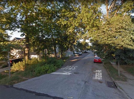
Nevada Avenue, Richmondtown
Like Florida Terrace, Nevada Avenue emanates from Rockland Avenue and travels through some rural terrain before reaching a more populous section with expensive homes. After some twists and turns, it dead ends at the hiking trail entrance to High Rock Park.

New Jersey Avenue, East New York
New Jersey is one of East New York’s group of northeast state streets, but again, follow-through. There are a smattering of such streets, enough to discern a pattern, but it seems half hearted and haphazard. Here, New Jersey Avenue runs beneath the Fulton Street el (J train).

New York Avenue, Crown Heights-Flatbush
New York Avenue is the lengthiest of NYC’s state streets, running, with one interruption, from Fulton Street south to Avenue N. The trip takes it past Kings County Hospital, seen here. I haven’t mentioned KCH much in FNY; I haven’t had the pleasure of receiving treatment or visiting someone getting treated here. It’s one of NYC’s oldest hospitals, though, with a lineage stretching back to 1830, when this was part of the Town of Flatbush, not NYC.
New York Avenue is of course named for the city, nit the state, but they all count! It’s part of a Brooklyn street-naming scheme in which north-south avenues were named for New York State cities, progressing east from those closest to NYC: hence New York and Brooklyn Avenues first, and ending with Buffalo Avenue.

New York Plaza, South Ferry
It doesn’t turn up on street signs…just three separate addresses of buildings constructed along Water Street in the 1970s, #1, 2 and 4 New York Plaza; the name must have been cooked up by real estate developers to unify the region. The brown building with the thin windows was home to Manufacturers Hanover, now Chase, and my mother worked in it for a few years after it opened and before her death at the young age of 58.

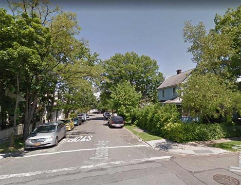
Oregon Road, Old Town
Oregon Road runs for a block or so along the Staten Island Railway cut west of Hylan Boulevard. The Old Town RR station and overpass can be seen on Old town Road to the left, while Oregon Road crosses it on the right.

Pennsylvania Avenue, East New York-Starrett City
One of East New York’s complement of state streets, it;s a major north-south route, connecting with the Jackie Robinson (Interboro) Parkway on the north and the Belt Parkway at its southern end. I’m surprised Robert Moses didn’t try to expresswayify it. Seen here, it runs through the 1970s housing project on its south end, Starrett City. The avenue was subtitled Granville Payne Avenue in 1985 to honor a local jazz musician and community leader.
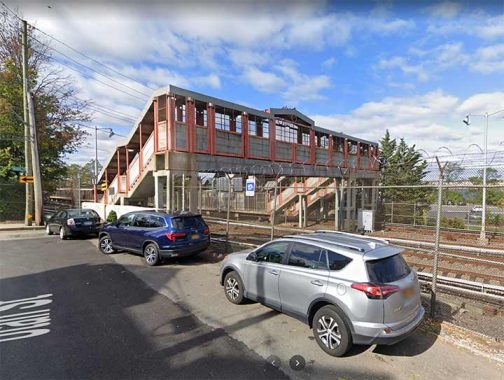
Utah Street, Tottenville
Unconnected to Tottenville’s New England streets (see above), Utah Street is something of a head scratcher. It runs for a couple of blocks along the south side of the Staten Island Railway, one of whose stations is shown here. The mostly-Mormon state is namechecked twice in NYC, with Utah Walk in Mill Basin (again, see above).

Vermont Street, East New York
Vermont Street (mysteriously not called an Avenue, like New Jersey and Pennsylvania Avenue) is another of East New York’s state streets. Here it runs past the Danny Kaye School, PS 149, named for the beloved 20th Century entertainer born David Daniel Kaminsky and who attended this school. His parents immigrated from Ukraine.

Vermont Place, Highland Park
Vermont Place is unconnected to Vermont Street, but connects Highland Boulevard and Cypress Avenue and the Jackie Robinson Parkway within Highland Park. Unlike Vermont Street, it’s completely within the borough of Queens.

Virginia Avenue, Castle Hill
The Bronx is a bit hard up for state streets, but it does have Virginia Avenue, which according to the late Bronx historian John McNamara in History in Asphalt was possibly named for Emily Virginia Sullivan, a freidn of the Gleason family who owned the property in the 1890s when the street was laid out.

Virginia Avenue, Rosebank
Another of Rosebank’s run of state streets,. On it, you can find this aged residence.
Virginia Street, Far Rockaway
Queens’ Virginia Street is almost out of town, just short of the undefended Nassau County border, running a few blocks in two sections from Brunswick Avenue to Elvira Avenue, which is neither named for the Oak Ridge Boys heroien nor the Mistress of the Dark. Here, Virginia Street meets Bolton Road at an L-shaped intersection.
Washington
Too many to mention here, but I do mention them on FNY’s NYC Presidents page, which is a fun read in its own right.
That’s it. Left out in the cold on NYC’s street map are Arizona, California, Hawaii, Illinois, Kentucky, Michigan, Minnesota, Mississippi, Nebraska, New Hampshire, New Mexico, Oklahoma, Rhode Island, Tennessee, Texas, Wisconsin and Wyoming; I’ll let West Virginia be counted with Virginia, a state it was once a part of.
As always, “comment…as you see fit.” I earn a small payment when you click on any ad on the site.
2/6/22
20 comments
No mention of that white early 70’s Dodge Dart (I think) in the Alaska St. pic? Bless Staten Island! It’s looking more bucolic and ruistic than Long Island these days. Love it!
Nice catch, Nunzio! That Dodge Dart has been there at least since 2009, when I was looking at a nice 1860s house for sale on Alaska Ave. Car hasn’t moved an inch!
Very nice! You mentioned that New York St in Staten Island became Bay St., but it still retains the New York St. name inside Fort Wadsworth. Thanks for the post – very interesting!
Some East New York info.
Vermont Avenue was renamed to Vermont Street (why, I don’t know) by the Brooklyn City Council on April 11, 1887, effective April 26, 1887. There’s also a Vermont Court in Highland Park, a dead-end lane off of the Jackie Robinson Pkwy. service road which is lined with brick rowhouses but has a few bungalows at the end complete with rural curbside mailboxes.
There were others.
Virginia Avenue (now Fulton Street), North Carolina Avenue (now Liberty) and South Carolina Avenue (now Glenmore) were the east-west counterparts, known by these names in the old center of East New York, between Alabama Avenue and Wyona Street. These names went out of use before New Lots Township was annexed into Brooklyn, so the documentation is hazy.
Two additional states were added circa 1869-74 when the Kings County Town Survey Commission laid out the streets in the southern part of the Town of New Lots: Louisiana Avenue and Mississippi Avenue. In January 1887 the New Lots Board of Trade recommended to the Council the renaming of 67 streets in the former Town of New Lots, with the proposed names having the same initial letter as the original name. The name recommended for Mississippi Avenue was Mitchell Street; after considering the variant Mississippi Street the name Malta Street was chosen. Renamed on April 11, 1887, effective April 26, 1887.
There’s also Virginia Place in Crown Heights.
The property bounded by Kingston and Albany Avenues, and Park and Sterling Places was subdivided into 52 lots by Ellis G. Potter (who had come into ownership of all the capital stock of the Virginia Beach Company), with Hampton and Virginia Places placed upon the map by the City Council December 20, 1897. This property ultimately came to be owned by developers Charles A. Haines & Co., who constructed 52 brick and stone houses.
I have Virginia Pl. on my list but forgot to include it, will get to that during the week
The building on the northeast corner of Atlantic Avenue and Vermont Street has embedded street name bricks. I’m almost positive that the Vermont Street side does show Vermont Avenue. I’ve seen maps from the late 19th and early 20th centuries that reference Vermont (or some subpart) as an Avenue. There are numerous references to Vermont Avenue in the Brooklyn newspapers well into the 20th century. Maybe for some people the Avenue habit was just hard to break.
Good posting. Never thought much NYC streets and avenues named for US states, but interesting to see. The champion city for “state” avenues is, of course, Washington DC.
But just east of Far Rockaway, in the nearby city of Long Beach in Nassau County, there is a whole collection of short avenues that go north-south on the narrow barrier island. A majority of US states are represented, but there does not appear to a logical geographic or alphabetical order. For example, one sequence of six going west to east is Virginia, Wisconsin, Wyoming, Alabama, Delaware, and Oregon. Regardless, it’s the closest large-scale use of “state” streets or avenues in the NYC area that I can think of.
The north shore of Staten Island, near the ferry terminal, has a Jersey Street, no doubt named for the English channel isle that’s also the state namesake. Of course, many New Yorkers call New Jersey simply “Jersey.” No one, of course, calls New York simply “York;” the Manhattan avenue with that name is not named as a shortened version of its home city, but for World War I military hero Sergeant Alvin York. Originally Avenue A, the re-naming occurred in 1928.
I’m thinking that it was convenient that there was an Alvin York, war hero, for the uptown Avenue A to be named after, so that it couldn’t possibly be mistaken for the Avenue A on the Lower East Side. It would be the sort of name, even absent the sarge, that nobody could object to, unless one was an absolute anti-royalist and thought it honored the Duke of York. I’m actually surprised that, in keeping with “Lexington” and “Madison,” they didn’t give it a more “patriotic” name like, e.g., Yorktown Avenue
Thanks Kevin. Didn’t realize Staten Island had so many streets named for states. Was looking at buying a house at #7 Alaska Street about a dozen years ago (you can see it at far right of the pic above). Gorgeous 1860s house that had the abandoned SI Cemetery for a backyard! Alas, the mega-long commute to St. George and Manhattan via the erratic Richmond Terrace bus stopped me from buying, and I ended up in California (go figure). Got my first job in summer 1981 at High Rock Park at the top of VERY steep Nevada Ave. Had to take the old S4 (now S59) bus for the entire route from Port Richmond Square to the last stop in Egbertville, then schlep along Rockland Ave (no sidewalks, as you mentioned) and up that very steep Nevada Ave slope. Man, when you’re 15 you have so much energy! One of my last SI apartments was in Old Town, and I’d commute to Midtown Manhattan by starting my three-legged journey via the SI Railway from Old Town Station. Always laughed at Oregon “Road” which is about as long as many SI driveways. Great memories, thanks!
Hi Kevin, interesting info about Prohibition and the campground in SI which included reference to the State of Maine as a leader in the cause. While true, and coincidentally there were several Maine towns still “dry” in to the 21st Century, Maine also was one of centers of “rum runners” during those times. Proximity to Europe and Canada coupled with a great many hidden coves, many Mainers supplemented their income with these activities. I personally knew a couple of spots in the town of Friendship, ME (one of the dry towns mentioned) that had buildings in the harbor that served the rum runners during the Prohibition era. More information here: https://www.mainememory.net/sitebuilder/site/2619/page/4223/display?use_mmn=1#:~:text=Bootleggers%20bringing%20liquor%20shipments%20into,in%20a%20variety%20of%20disguises.
Great piece, Kevin. It kept gnawing at me that
I Iknew of a Virginia something or other near my house. I couldn’t remember if was Virginia Street, Place, Avenue, Lane or Court. It finally dawned on me that there is a Virginia Place in Crown Heights, Brookly. It’s a one block street that runs parallel to Kingston Avenue between Park Plwce and Sterling Place.
You mentioned the numerous north-south “New York State city” avenues in Brooklyn (I call them the Thruway series). Syracuse is omitted in the series – ironically, I moved to Syracuse after growing up in Brooklyn and graduating from CCNY.
Never thought of Syracuse being omitted, but true. A few blocks east of Buffalo Ave., there is a Saratoga Ave. as well. Of course one could argue for other cities that should have been included – Poughkeepsie, Newburgh, Rome, Oswego, for example, but who knows exactly what the Brooklyn city fathers were thinking in the 19th century. My mother was born in Brooklyn, and my father was born in Buffalo, so I’m covered!
I may be recalling something incorrectly, but weren’t the Brooklyn city-named streets – I always remember them as BRUSTAK BN – named after the major cities along the Erie Canal and Hudson River? Under that scenario, Syracuse would be omitted as it was not on the canal route.
It looks as if Staten Island’s astronaut streets owe their monikers to an imaginative developer. Most of the houses on them look about the same age, from the late 1960’s which woould tie in with the astronaut theme.
Great post! Never realized how many.
Are there any streets named for foreign countries?
I’ll get to that later.
Does anyone know of Anchorage Place in Dumbo, Brooklyn? If you think it’s named after a city in Alaska, then you’re incorrect. Since It’s SO CLOSE to the Manhattan Bridge, it was named for an important part of the crossing.