

I’ve been round these parts before — in fact, I’ve done a survey of Canarsie’s still-numerous, but dwindling number of alleys before, in 2008 as a matter of fact. However I didn’t get to all of them then, and even after this trip in 2019 I still won’t have photos of each and every one. I’ve visited Canarsie repeatedly for its odd between-block roadways — the first time was in 1999 when I first began gathering material for the site. Canarsie’s alleys have not been widely photographed over the years — official city chroniclers ignored them, and there has never really been significant interest or notoriety attached to them. However, the back roads of Canarsie point to its small-town origins.
The photo indictes that Truckleman’s Lane, at East 98th Street, has been at least partly privatized as shown by the fence. A similar fate befell the eastern end of Lake Place, another ancient lane in Gravesend.
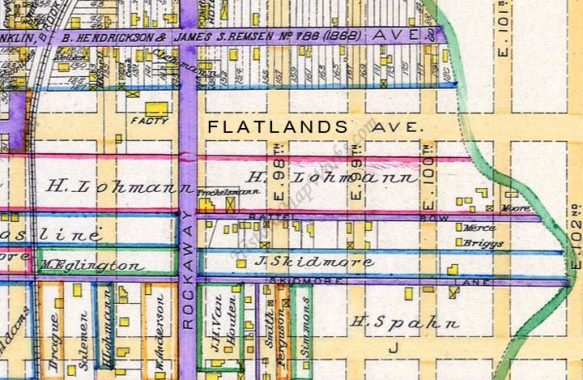
This closeup version of an 1890 Canarsie map shows both Truckleman’s Lane which in 1890 was named Battle Row (misspelled here as Battel Row) but it later took on the name of an adjacent property owner, Trochelsmann, and had its spelling somewhat modified.
Truckleman’s Lane is easily entered from Rockaway Parkway where you will find a quartet of very old buildings, most overlaid with aluminum siding, except for the fourth, which is derelict and falling apart. It’s impossible to go further, as a gate bars access to East 98th, thus you have to go around the block and proceed east again from East 98th, where you will once again find a pair of homes on the side of the lane. This likely explains Truckleman’s Lane’s continued existence. Though Truckleman’s Lane is not gated from East 99th, it seems to clearly be on private property, even though it is a mapped city street as indicated by the presence of Department of Transportation street signs. Ditto at East 100th, where it is part of a driveway but is on a direct line with the rest of the lane.
More photos of Truckleman’s Lane and additional Canarsie alleys on this FNY page from 2015.
As always, “comment…as you see fit.” I earn a small payment when you click on any ad on the site.
10/4/2015
5 comments
As has been mentioned before on this board, just because it’s fenced off to give it the appearance of being private property, it’s sometimes not. The NYC street signs say otherwise. If the street was demapped and sold, wouldn’t the signs come down?
Looking at the City’s DOF and GIS online maps and reading some of the deeds of properties fronting on Truckleman’s Lane – and others in the area – it appears that the Lane is actually the private property of abutting property owners with the Lane width treated as an easement or right-of-way.
Your post got me looking at Google Earth. Notice the block bordered by Flatlands, Avenue J, E. 95th, and E 96th. There’s an apparent alley used for parking off E. 96th, with a sliding gate blocking access beyond the depth of one lot. But behind that is a well-paved area with painted parking spaces and a park-like green space the width of about 5 houses. It does not appear to be contiguous with any house. None of this is evident from the streets. There must be a story.
That’s the Skidmore Lane that you can also see on the atlas plate above.
My family and I moved to Canarsie in 1958. My mom loved researching Canarsie’s history. We lived on Truckleman’s Lane. About 3 houses down from us were the Skidmore’s. We learned that Truckleman’s Lane was originally Skidmore Lane. Skidmore married Trochleman hence the change in the name of the lane. When my mom went downtown to pay her water bill it was listed as Battle Row.