

By SERGEY KADINSKY
Forgotten NY correspondent
On my previous visit to Coney Island, I documented a former bathhouse that became a Parks Department garage. I was informed that it will soon be demolished, joining a set of other former bathhouses that I’ve described in the past. This time, I walked the last ten blocks of the Riegelmann Boardwalk to search for more forgotten items.
At West 32nd Street, maps show a half-block dead-end Sea Place, a rare street on the blocks between Surf Avenue and the Boardwalk. It is short, but as it appears on the official city map, it could have addresses on it, if there were any homes on it. On his visit to Sea Place in 2019, Kevin noted its past as the address of Lincoln Baths and a set of abandoned bungalow dwellings.

A look at the neighborhood in 1920 shows numerous bathhouses near Sea Place. At the time, the Norton’s Point Trolley connected Sea Gate to the subway at Stillwell Avenue. It ran until 1948, replaced with the B36 bus route.
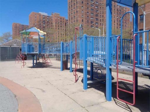
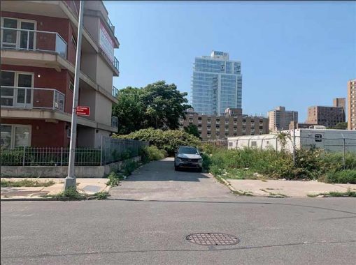
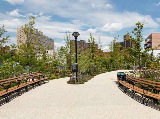
A block to the east, Nautilus Playground was built in tandem with the NYCHA Coney Island Houses, wiping Edward Place on West 30th Street from the map. The playground’s basketball courts were featured in the Spike Lee film He’s Got Game.
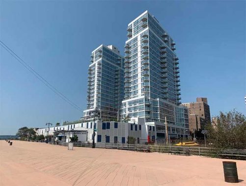
The most recent development at the west end of Coney Island is Ocean Drive, a pair of market-rate glass-box condos built by supermarket executive and WABC radio owner John Catsimatidis. Their name and architectural style evokes Miami Beach but on a closer look the private pool and green rooftop are not visible from the Boardwalk, likely a security consideration by the developer.

At W. 33rd Street the Boardwalk loses its historical boards in favor of concrete. It was a controversial decision in which preservationists argued that the removal of wooden boards would turn the iconic walkway into a concrete road. So far, only two sections have been paved with concrete: two blocks between Brighton 1st Street and Ocean Parkway; and the blocks to the west of W. 33rd Street. Other stretches of the boardwalk were given recycled plastic lumber (RPL), which appears like wooden boards but is more durable. Changes to the appearance of the boardwalk must receive the approval of the city’s Public Design Commission as it is a designated Scenic Landmark.
At the western tip of the Boardwalk there are no monuments to congratulate joggers for completing its 2.7-mile run. But there are good views of Staten Island, the highlands of New Jersey, and the private neighborhood of Sea Gate. It would be nice to have an elevated platform here to enhance the views, or a memorial to Brooklyn Borough President Edward J. Riegelmann, who promoted the construction of the boardwalk, or its designer Philip P. Farley.
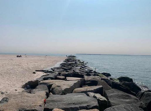
The jetty constructed to keep the beach in place prevents sand from drifting westward. As is the case with the West End of Jones Beach and Breezy Point, the current pushed the sand towards the jetty, resulting in the widest section of the beach at W. 37th Street.
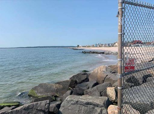
In contrast, without new sand to replenish it, the shoreline on the Sea Gate side of the jetty has not changed in decades. A border fence attempts to keep the public out of Sea Gate, and I’m sure it hasn’t worked. It reminds me of the border wall at Tijuana Beach.

A search in the Municipal Archives finds plans for the Boardwalk that were never realized. In the 1960s, the city proposed a fishing pier at the western tip of the boardwalk, along with a linear midblock park between Surf Avenue and the boardwalk. At the time, all of Coney Island between Stillwell Avenue and Sea Gate was designated as an urban renewal area. Old bungalows and wooden walk-ups would be replaced with public housing projects.
The Brutalist tower at 2727 Surf Avenue straddles W. 28th Street, and there were plans for a set of such towers but only one was completed here in 1970.
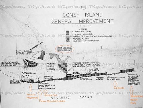
An earlier plan from 1952 envisioned extending the boardwalk east to Manhattan Beach, a stretch that was the Esplanade. It was privatized in the 1980s. The plan also sought to fill the section of Coney Island Creek between Stillwell Avenue and Shell Road with housing.

Where public housing does not straddle streets, it simply blocks them. O’Dwyer Gardens, named after the city’s 100th mayor, William O’Dwyer. He promoted the redevelopment of Coney Island. He was well-liked, running as a former cop and district attorney. But a year into his second term in 1950, he abruptly resigned in a corruption scandal.

This project was completed in 1968, during the administration of John V. Lindsay. Among his pet projects were vest-pocket parks and housing that filled in empty lots in distressed neighborhoods.
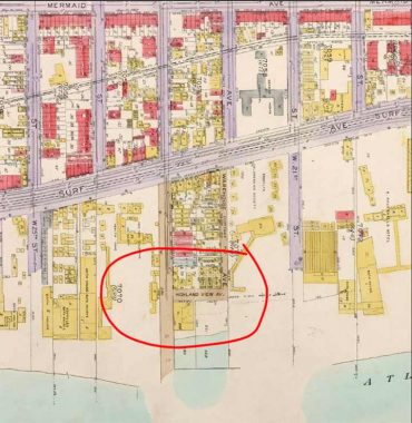
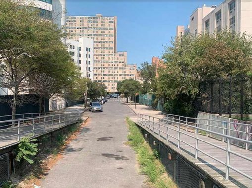
Highland View Avenue is another one-block road near the Boardwalk that’s no longer with us. It ran between West 22nd and 23rd streets. It was demapped in 2014 to make way for Seaside Park and the Ford Amphitheater. The concert stage occupies the landmarked former Child’s Restaurant that was beautifully restored and functions again as an eatery.

Prior to its decommissioning, Highland View Avenue had some addresses on it and simply provided good parking close to the beach, for those who knew about its location. In my childhood visits to the beach, I dreamed about seeing the other side of the Lower Bay. Taking a ferry from Wall Street to Sandy Hook, I was fascinated by the nature, military history, and views of Brooklyn from the opposite shore.
The route of Highland View Avenue is now a park with landscaping that rises above the boardwalk to withstand storm surges.
As far as “forgotten” items on Coney Island are concerned, there are many. Among my favorites are the other lost streets nearby, local murals and alleys, and its neighborhood museum.
Sergey Kadinsky is the author of Hidden Waters of New York City: A History and Guide to 101 Forgotten Lakes, Ponds, Creeks, and Streams in the Five Boroughs (2016, Countryman Press), adjunct history professor at Touro University and the webmaster of Hidden Waters Blog.
As always, “comment…as you see fit.” I earn a small payment when you click on any ad on the site.
10/2/22
10 comments
Great article,all the links are interesting too.
It must cost a lot of money to maintain a wooden boardwalk.
I notice on the map showing Highland View Avenue that West 22nd Street is labeled as “Warehouse Avenue”. This avenue was proposed to have continued into Bath Beach/Bensonhurst parallel to Cropsey Avenue and running up to about Dyker Beach Park, with another piece between the park and Fort Hamilton, about where Poly Place is today. Much of what would have been the Bath Beach section of Warehouse Avenue is now covered by the Belt Parkway; Independence Avenue may also be a part of it.
Are you sure you were on the CONEY ISLAND boardwalk? When I was last there in the 1990’s, it was lined end-to-end with Russian speaking babushkas. I don’t see anyone in your photo’s!
That’s the east end.
Thank you for another very informative posting. Mayor William O’Dwyer has another historical connection to the west end of Coney Island’s boardwalk, one that he would probably rather forget. In November 1941 O’Dwyer was the Brooklyn District Attorney, and was prosecuting a group of gangsters know as Murder, Inc., who were based in Brownsville and East New York. One Murder, Inc. hit man, Abe “Kid Twist” Reles, became a government witness whose testimony had sent several mobsters to prison and in some cases the electric chair.
In November 1941, Reles was being held in protective custody at the Half Moon Hotel, at West 29th Street and the Boardwalk. Despite the fact that a whole posse of policemen were guarding Reles, he somehow fell out of his sixth floor room and was killed. Whether the incident was an accident or intentional has never been completely established. Reles was scheduled to testify in court the following day again a key Mafia boss, Albert Anastasia, so it is likely he was pushed.
Ever since Mr. Reles became known as the canary who could talk but could not fly.
The Half Moon Hotel was razed in 1995 and today the Seagate Rehabilitation and Nursing Center occupies its site.
Source: Wikipedia https://en.wikipedia.org/wiki/Half_Moon_Hotel
I clearly remember Highland View Ave. A long name for a short street. My family and I would spend hot summers cooling off at the Washington Baths Annex across the street. My dad once told me he used to swim at that pool when he was young. He told me one day some building located on West 22nd st burned down. That’s probably why that land between West 23rd and West 22nd St was vacant for years and served as a parking lot as I recall.
I always thought that with its distance from Manhattan there wouldn’t be so much luxury development in Coney Island, but that doesn’t seem the case as there have been some recent protest of giving up certain parts of the boardwalk to them.
great presentation, I am 81 and everything except the boardwalk looks so different, I hope it stays that way, btw 2.7 miles is not as long a distance as joggers usually do, I did 5.2 every day when I was younger. That’s one thing NY lacks is a long unobstructed place to run, too many people in central park, even when I went to college up near the park.
Just for the record, Kevin, the Norton’s Point trolley was replaced by what at that time was called (on the Stillwell Terminal signage) the Norton’s Point Bus. That is, the B74 Mermaid Avenue bus, not the B36. But, ironically, it didn’t go any farther than W.37 St.