

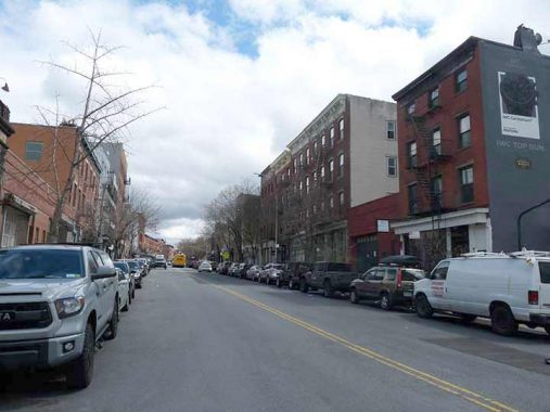
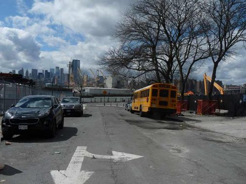
WHEN I walked the full length of Brooklyn’s Kent Avenue from DeKalb Avenue north to Franklin Street and North 14th Street in 2008, I was documenting a road that experienced a great deal of change since the way it was in the 1970s, when I traveled it in a rickety van with a group of other teenagers from our school on Washington Avenue to a long gone bowling alley in Greenpoint on Humboldt Street. At that time its north end was given over to breweries (most famously, Schaefer), warehouses, factories and the railroads that connected all of them and there was nary a thought that it would become a boulevard lined with luxury high rise residences and parks. A 2005 zoning change paved the way for the new buildings and conversions seen along Kent Avenue today.
While I saw the last of Kent Avenue industry in 2008, when I decided to travel it again in 2022 I found a nearly completely different road as most of its old flavor had disappeared. But not all, and I tried to snap as much of the old stuff as I could. Instead of my 2008 trip, this time I traveled north to south. It wasn’t a great day for photography with dark clouds, which cleared somewhat later in the day. I used the magic of Photoshop to brighten up some of the photos.


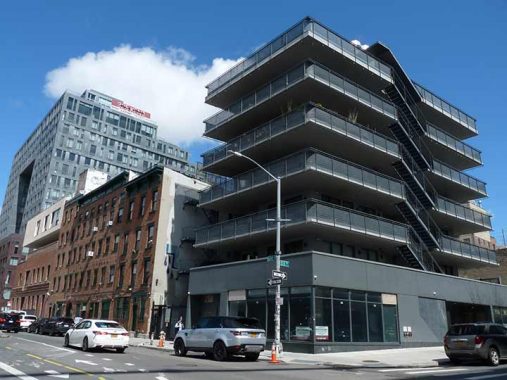
Examples of modern architectural nonsense at Kent Avenue and North 3rd. (Yes, I like some examples of modern architecture, but neither of these). When I was rattling up Kent Avenue in a van in the 1970s, the idea of a shopping center in these parts would have been laughable, but thousands of living spaces, most of them expensive, have popped up near the East River waterfront in Williamsburg since the early 2000s.
Trader Joe’s, which sells its own branded merchandise instead of national brands, was founded by Joe Coulombe in Pasadena, California in 1967. I have only been in a Trader Joe’s once and i think it was out of town; the chain has never been in my neighborhoods of Bay Ridge, Flushing and Little Neck while I’ve been a resident. In Williamsburg, Trader Joe’s replaced Duff’s, a biker bar since relocated a few blocks east to Marcy Avenue near Broadway.


A number of very lengthy streets begin at Kent Avenue, or at the East River just west of Kent Avenue. Metropolitan Avenue, seen here looking east and west from Kent Avenue, is one of the lengthiest routes between Brooklyn and Queens. It was first built in 1815, give or take a year, as a toll road and was known along much of its length as the Williamsburg and Jamaica Turnpike until the mid-1800s, when it was bestowed its current name. It runs from the East River to Jamaica Avenue and along the way, marks the southern limit of Newtown Creek, and runs through Lutheran/All-Faiths and St. John’s Cemeteries, as well as Forest Park. It’s the spine of several communities — Williamsburg, Middle Village (so named because it was midway between Williamsburg and Jamaica), and Kew Gardens, and forms the boundary line between Ridgewood and Maspeth.
A number of very lengthy streets begin at Kent Avenue, or at the East River just west of Kent Avenue. Grand Street is a long road with two distinct sections. The western end of the street in Brooklyn runs east-west through the heart of Williamsburg all the way to the East River, while the east end crosses Newtown Creek and winds its way to the heart of what used to be called Newtown but is now Elmhurst. That section has been called Grand Avenue since the 1920s to differentiate it from Brooklyn, but it evolved out of what used to be the tolled Newtown Plank Road. The two ends of Grand Street were hewn together in 1875 when they were linked by the first Grand Street Bridge over the creek (the present one, which has had a replacement discussed for years, was built in 1902!). Grand Street/Avenue became an important farm to market road from the wilds of eastern Queens County to East River shipping.
I have walked its length on a couple of occasions, in 2011 and again in 2021.

In a part of Williamsburg bristling with new buildings and developments, the old Northside Bank Building at #33 Grand, just off Kent, is still around. The Romanesque Revival structure was designed by Theobald Engelhardt and completed in 1887. Engelhardt also designed the Ulmer brewery complex and Arion Mannerchor Hall, which are on the Bushwick-Williamsburg border a couple of miles to the east. The Northside Bank was acquired by Manufacturers Trust in 1922, which has evolved into today’s JP Morgan Chase. The building isn’t landmarked, but is a survivor.


Here’s an example of a new building with a modern design I don’t mind at all. In fact, if I had the $$$ I’d purchase an apartment here. At Grand and Kent we can see a gigantic object that looks like a tuning fork, with incredibly large windows on its north “tine.” This is a giant residential building called 1S1, or #1 South 1st Street., a.k.a. Ten Grand. It’s the tallest residential building in Brooklyn and ranks among its tallest buildings of any kind. 1S1 is 45 stories tall with 330 apartment units. It’s 435 feet tall, has a rooftop pool, unparalleled views of the East River, Brooklyn, Manhattan and New Jersey, and unless MegaMillions enables it, I will never see the inside of it. Real estate website 6 Sq Ft is aware that most people will never get a good look either, and has artist renderings of the interior. I especially like its white exterior and squarish picture windows.
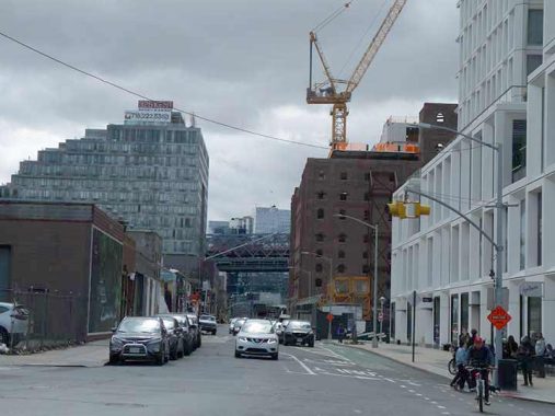
New and old Kent Avenue, seen looking south from Grand Street. The new #325 Kent, built with a “bridge” similar to 1S1, is at left, with the ancient Domino Sugar plant and 1S1 on the right. The approach to the Williamsburg Bridge spans Kent Avenue in the distance.
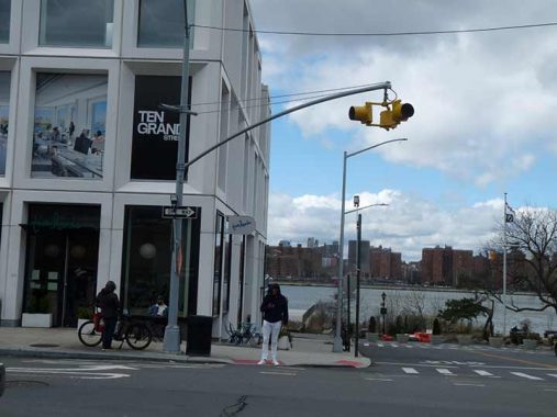
In 2022, the intersection of Grand and Kent still rated only a blinking Cyclops traffic signal, but I suspect three-lampers will be installed as the intersection gets busier. In the distance is Grand Ferry Park, site of a former ferry to Manhattan.


According to local legend, when the Domino sugar refinery at #292 Kent Avenue and South 2nd Street was still operating, the smell of caramelized sugar could be sniffed in the immediate vicinity. The plant, instantly recognizable from the J train on the Williamsburgh Bridge or from boat traffic in the East River by its huge illuminated sign, shut down in early 2004 after about 150 years in business, putting 200 employees out of work. American Sugar Refining Company officials said the Brooklyn plant was not equipped to compete with its plants in Baltimore, Yonkers, N.Y., and outside New Orleans, according to WCBS News.
Domino’s history in Williamsburg began in 1856 when executive 1856 Frederick C. Havemeyer Jr. leased a property where the water was deep enough to construct a dock for ships. His brother William F. Havemeyer served as a three-term New York mayor, with his name given to Havemeyer Avenue in the Bronx. The Refinery was constructed in 1884 and was designed by Theodore Havemeyer (grandson of Frederick) and John Van Vorst Booraem.
Thankfully that wasn’t the end for this brick beauty and it is being rehabbed and renovated as offices and event spaces, The Refinery at Domino. In 2022 its iconic lit sign, yellow during the day (to match the old Domino Sugar packaging) was restored and glows red at night. It was not originally mounted on the refinery building, but on the now-razed Filter House.


I ducked into Domino Park, which runs along the waterfront in back of the sugar refinery; the park, one of a number to spring up as public access to the waterfront has increased hundredsfold since the 2005 rezoning. The views across the river are spectacular. Sergey has the details about this wonderful new park. I make sure to visit Tacocina for lunch while there, but April was too early in the season and it was closed.

The Refinery is seen here with the new #325 Kent, which is constructed with a bridge between two towers resembling an upside down “U.” The 17-story apartment tower was the first to be completed in the Domino Park complex. It replaced Havemeyer Park, a pop up park created by the demolition of older warehouses along Kent Avenue.

In 1863, Frederick C. Havemeyer Jr. reorganized the business as Havemeyers & Elder, a partnership with son Theodore A. Havemeyer (architect of the Refinery) in charge of refinery operations and son-in-law J. Lawrence Elder in charge of the mercantile business. The sign you see here, facing the river, was added a couple of years ago and I presume weathering will make it appear older to match the rest of the building in future years.
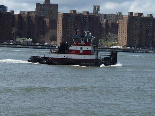
The tug James William heads north on the East River. She was constructed in 2007 by C. & G. Boat Works in Mobile, Alabama and refit in 2018 by Feeney Enterprises in Kingston, New York.
I feel fortunate to live in a “city of water” for its views and to be able to monitor activities on the waters surrounding the city. In NYC you are never far from a body of water of some kind.
As I visit NYC’s new waterside parks, I think of the thousands of individuals that were employed along the waterfronts for centuries before the present time and how most of that employment has vanished; now NYC’s watersides are used for play. Good for people scuttling around with cameras, I suppose.
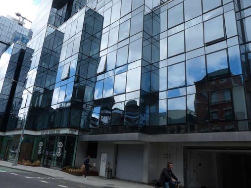
#21 South 5th Street, NE corner of Kent Avenue. I don’t know why the entire exterior of the building was given over to staircases and walkways. The windows are set back and the views of the river and the Williamsburg Bridge must be severely restricted.
A look west on South 6th Street affords an excellent view of the bridge. I have always desired rooms with a bridge view. When I lived on 73rd Street on a 4th floor in Bay Ridge, I was high enough to see the distant cable lights of the Verrazzano Bridge during the winter, and I later looked at an apartment on 95th Street with a clear bridge view, but didn’t get it.

A tiny alley, Dunham Place, runs for a block between Broadway and North 6th Street just east of Kent Avenue and I cannot resist checking in on it when I am in the area. It still has most of its 19th Century brick buildings. It was named for early ferry pioneer David Dunham (1790-1823) who died when… he went overboard from a steamship.
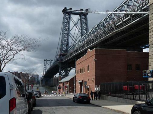
As it has since the 1870s Brooklyn’s Broadway begins at Kent Avenue and moves, in nearly a straight line, southeast to the junction formed by Fulton Street, Jamaica Avenue and Pennsylvania Avenue on the borders of Bedford-Stuyvesant, Brownsville and Bushwick. Along the way it forms a barrier between Bedford-Stuyvesant and Bushwick and serves as a dividing line in street systems, which is quite clear when consulting a Brooklyn map. While today only the short stretch of Broadway between Kent Avenue and the Williamsburg Bridge plaza is unshrouded by an el — the section we deal with on this page — until the 1930s even this short stretch was denied sunlight as a spur from the el connected to a now-forgotten ferry.

At Broadway and Kent, on the right, is a wonderfully decorated 4-story peaked brownstone building topped by etched ornamentation and shield containing the date of construction. I last examined the section of Broadway in Williamsburg unshrouded by an el way back in 2005 and I should get over there again for another look though fortunately, much of its fantastic 19th Century architecture has been preserved. As far as I’ve been able to discern in recent visits some of its quirkiness (seen on the link) remains as well.
Broadway and Kent Avenue is where the very first Forgotten New York tour stepped off on June 1, 1999. In attendance were Frank Jump, king of NYC faded ads; Steve Anderson of NYC Roads fame; and Jeff Saltzman, original king of NYC lampposts before moving to North Carolina.
There have been 152 more “live” tours, but none since 2019 as the pandemic and then my own unrelated health issues have prevented them; I have been doing Zoom “Forgotten tours Indoors” and if the doctors can identify and fix the issues, I will return to touring. Or not — the Zoom tours are easier!
A trio of luxury, tetrahedonal glass-walled towers, 420 Kent, developed by a group headed by former NY State Governor Eliot Spitzer, the self-styled “f!ckin’ steamroller,” was completed in 2019. Once again, the likes of “your webmaster” would never be able to afford an apartment here, but YIMBY.com provides some info and interior photos. Spitzer was forced out of office when he was caught cavorting with an escort. Hey, I shouldn’t playa hate.
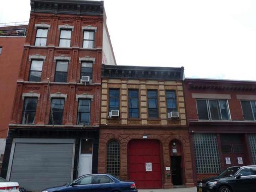
420 Kent faces these three venerable buildings across the street, 409, 411 and 413 Kent. I had posited a couple of years ago that the one in the center, 411 Kent, had been a firehouse, but Comments pushed back on that one.
Here’s a look at some painted ads from buildings on Kent Avenue near the Williamsburg; the buildings have since been razed and partially replaced by the building with exterior walkways shown above. A second look.


Schaefer Landing, 440 Kent Avenue and South 9th Street, is a 2-building, 350-unit residential development designed by architect Karl Fischer and completed in 2006. The short riverwalk is a nice touch, as is the Coke bottle green color scheme and NYC Ferry stop. There were a couple of ferries gassed up and ready to go, but I had more walking to do.


Schaefer Landing is so named because it occupies the lot where Schaefer beer was brewed for many years. Prussian immigrants Frederick and Maximilian Schaefer founded the brewery in 1842, producing one of the first lagers in America. After occupying several locations in Manhattan, Rudolph Schaefer, the son of Maximilian who had ascended to CEO in 1912, sold the plot that became home to St. Bartholomew’s Church on Park Avenue and looked across the river to Williamsburg to build and expanded plant. Schaefer operated in Brooklyn exactly 60 years, from 1916 to 1976.
You remember the radio commercials: “Schaefer… is the… one beer to have when you’re having more than one.”


I haven’t been able to identify the original purpose of this 10-story “house of many windows” at #485 Kent Avenue and South 11th, but the ground floor has been under renovation for some time. Comments are open below.
Note: I have a response (see Comments)
Somewhere, I have photos of a walk I did on the full length of Division Avenue, which runs from the waterfront to Broadway, crossing Kent Avenue; here’s the river stub. In Manhattan, Division Street was laid out along the border of the Rutgers and DeLancey farms, but in Brooklyn it simply defined the southern border of the city of Williamsburg, which was annexed by the city of Brooklyn and ultimately to NYC.


Jacob’s Ladder Park was probably named by former Parks Commissioner Henry Stern, who enjoyed bestowing colorful names. Stern probably never heard of Huey Lewis and the News or the Tim Robbins movie, but he did hear about the Old Testament story of the vision that patriarch Jacob had.
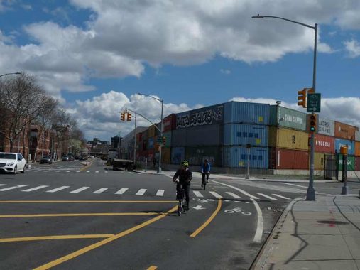
Kent Avenue bends south at Clymer Street and borders the Brooklyn Navy Yard for several blocks. Here we see some of the containers that revolutionized shipping in the 1960s and spelled doom for NYC’s waterside industries.

Steiner Studios has developed into a major moviemaker since moving into its 20-acre, 10-soundstage complex in the Navy Yard in 2003, at the largest movie studio outside of Hollywood.
Among the major motion pictures filmed at Steiner Studios are The Producers: The Movie Musical, Fur, Then She Found Me, The Tourist, Across the Universe, The Hoax, Funny Games, The Nanny Diaries, Life Support, Spider-Man 3, Men in Black 3, Mr. Popper’s Penguins, The Adjustment Bureau, Sex and the City 2, The Tempest, Revolutionary Road, My Super Ex-Girlfriend, Inside Man, Enchanted, Baby Mama, The Sorcerer’s Apprentice, and Burn After Reading.
Steiner Studios also has hosted many television series, including, Damages, Flight of the Conchords, Clash of the Choirs, The Unusuals, Pan Am, Bored to Death, Boardwalk Empire, Girls, and Hip Hop Squares. wikipedia

Parts of southern Williamsburg, and northern Bedford-Stuyvesant, were given names of the signers of the Declaration of Independence in July 1776. Early abolitionist Caesar Rodney was one of the signers from Delaware (though it may seem like it, fellow Delawaran Joe Biden wasn’t around yet in 1776).
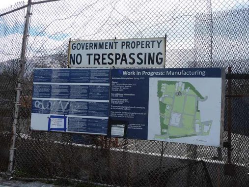
If you walk around the Navy Yard on Kent and Flushing Avenues, you can still find leftover signs from when this was a government facility. No matter; much of it, except for a ferry landing and Walgreen’s Wegman’s supermarket, are still private property and is under heavy guard.


At Williamsburg Street West and Kent Avenue you will find a much-needed green space, the Naval Cemetery Landscape. Between 1831 to 1910, more than 2,000 people were buried here, mostly members of the armed forces. In 1926, the Navy relocated the dead to the Cypress Hills National Cemetery. An archeological study in the 1990s determined that hundreds of bodies remained buried beneath the grass. This inspired the construction of the wildflower meadow and elevated walkway. A honeybee colony feeds off the plants of this green space.
I’ll end here though I walked Kent Avenue to its south end at DeKalb Avenue; those images may make it to a separate page.
As always, “comment…as you see fit.” I earn a small payment when you click on any ad on the site.
6/11/23
11 comments
To find out more about the American Sugar Company/Domino Sugar in Williamsburg, read “Merchants of Williamsburgh: Frederick C. Havemeyer, Jr., William Dick, John Mollenhauer, Henry O. Havemeyer” written by Harry W. Havemeyer. The Elder family is also related to them.
You didnt go up by the Navy Yard when I was a kid in the 60s.The youth up
there ran in packs like wild dogs and I would have been a goner just like in
Lord of the Flies,that one about those depraved young punks.
Your answer to the multi-windowed factory building on Kent & S 11th St, from my own research:
Multi-Tenant Lofts
Built in 1911. 11 floors.
This factory was built on the grounds of the Riverside Chemical Works, one of dozens of chemical and dye manufacturers that lined the north Brooklyn waterfront in the late 19th Century. Upon its construction, the building‟s earliest tenants included the Charles Fischer Spring Company, the Arcadia Knitting Mills, and the Baker-Lockwood Company, all during the 1910s and „20s. Charles Fischer, originally located at 88-90 Walker St. in lower Manhattan, manufactured metal springs, flexible metal tubing, and speedometer shafts. In 1916, the firm relocated its manufacturing operations to this location, while maintaining its Manhattan site as offices and a stockroom. The Arcadia Knitting Mills, founded in 1919 by Isidor Reinhard, produced knitted rayon underwear, with a workforce of 250 people, and a second plant in Allentown. The Baker-Lockwood Manufacturing Company manufactured a wide range of products, including waterproof tents, hangers for planes and ships, cockpit and fuselage covers, and lifebelts. By 1921, the company had declared bankruptcy, closing its New York headquarters, as well as its Kansas City branch. In 1930, and lasting through the 1960s, the majority of this site housed macaroni producer V. LaRosa Company, founded by Vicenzo LaRosa in 1914. Originally selling his product from a small storefront in Williamsburg, the company grew to become one of the largest regional brands in the nation, with 40 varieties of pasta, and plants in Milwaukee, Connecticut, and Pennsylvania. The firm remained in LaRosa family control until its acquisition by the American Italian Pasta Company in the late 20th Century. The building continued to house small manufacturers through the early of the 21st Century, from electronics firms to warehouses and matzo producers, with large sections converted to semi- legal residences and gallery spaces.
Here’s the Schaefer radio ad:
https://www.bing.com/videos/search?q=the+three+degrees%2fschaefer+ad&refig=b27b8ab842cf49f6923532796d7df780&mkt=en-us&ocid=hpmsn&ru=%2fsearch%3fq%3dthe%2bthree%2bdegrees%252Fschaefer%2bad%26form%3dMSNSB1%26refig%3db27b8ab842cf49f6923532796d7df780%26mkt%3den-us%26ocid%3dhpmsn&view=detail&mmscn=vwrc&mid=FDEF25683C1C71EBE680FDEF25683C1C71EBE680&FORM=WRVORC
I believe you mean Wegman’s as the supermarket at the Navy Yard. They’re first in NYC, but much smaller than their usual stores upstate and elsewhere. My wife and Alec Baldwin’s Mom swear by them.
Correct
Back in the 1970’s, with a new driver’s license, I would borrow my Mom’s car to drive from our house in Whitestone to go to a friend’s house in Flushing.
What she didn’t know was that we took excursions down into Brooklyn to “explore”. One of our favorites was Kent Avenue. There was still a bit of industry left, but much had already gone and left early ruins behind. One standout memory was the gutted remains of a steam locomotive stranded on the water-side of Kent Avenue that had once belonged to one of the small rail lines that had served local factories.
We always put in enough gas (about $.40 per gallon) to return the car with the same gas amount as before it was borrowed. Thank God she never checked the odometer!
Tugboats are starting to look less like tugboats and more like
airport control towers plopped onto barges
I remember when Kent Ave., up to Williamsburg St. West, was paved with red bricks.
As late as the 1970s.
Actually, until 1989-90. I used to regularly drive on Kent Ave. to get home in Greenpoint. The stretch along the Navy Yard, between Clymer and Hewes/ Williamsbug St. W.
was still paved with red brick during this time.