

I am taking the July 4 weekend off and doing minimal website activity (and even pausing from “real” job activities; I usually do a couple of hours on Saturday and Sunday) so am letting Sergey take the conn for the Sunday page. –Ed.
BY SERGEY KADINSKY
Forgotten NY correspondent
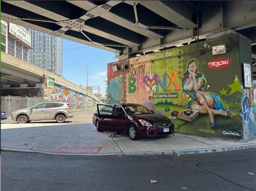
ONE of the storied roads of the Bronx is Bruckner Boulevard, which runs from Mott Haven to Pelham Bay Park, with most of its route in the shadow or as a service road of the expressway that shares its name. At the bottom of the South Bronx, Kevin noted its beginning in 2023, beneath the approach ramps of the Third Avenue Bridge, themselves covered in murals by the famed Tats Cru. Before you call Chuck Norris or Charles Bronson as your bodyguard for this tour, know that a lot has changed here, this formerly industrial waterfront now has glass towers defended by doormen. In the South Bronx!
The story of Mott Haven began in 1841 when industrialist Jordan L. Mott purchased land here for his iron works, where he manufactured anthracite coal-burning stove, cupola furnace, stove grates, cooking ranges, fireplaces, bathtubs, cauldrons and bathroom plumbing fixtures. Prior to Mott, this was part of the Morris family’s vast colonial manor, which appears on today’s maps in Port Morris, Morris Heights, and Morrisania.
Designing what can be called a company town, he donated land for a railroad and carved a canal out of a creek, setting aside parcels for other manufacturers along the shoreline, tracks, and canal. Walter Grutchfeld was a detailed essay on Mott’s ancestry and his family’s contributions to the city. The company operated in Mott Haven until 1902.
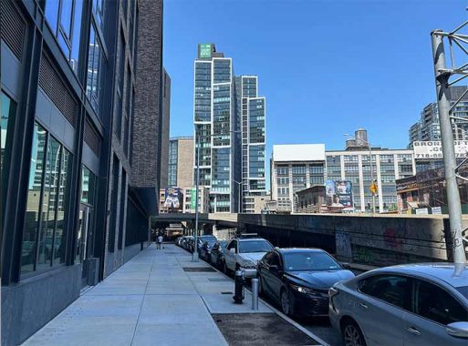
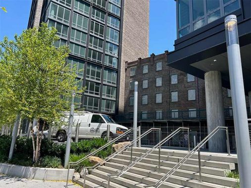
Facing the beginning of Bruckner is Maven, a 200-unit tower completed in 2023 by CetraRuddy Architects. The building features a spacious lobby with artworks and a green rooftop, but it’s not all upper class as it includes 60 rent-stabilized units. Its name is a portmanteau of Mott Haven and also a Yiddish word with Hebrew origins that translates as knowledgeable or an expert.

At the corner of Third Avenue, a non-operational neon sign has Bruckner’s name. It was installed by the late Bruckner Bar & Grill, an early harbinger of change in this neighborhood. In 2013, facing a lawsuit it changed the name to Mott Haven Bar & Grill and it survived for another decade. The building then made history again when the borough’s first legal cannabis dispensary opened here in 2023.

Between Maven and Third at Bankside tower is an old brick structure built between the 1860s and 1890s by the Mott Iron Works. Brookfield Properties, the developer of the Bankside towers, preserved Mott’s old building as a historical element amid the glass box high-rises. I can imagine the alley here having a future as a hidden party spot akin to Extra Place and Freeman Alley of lower Manhattan. For a city of its size, New York City has few alleys with names and addresses.

The driveway to Bankside is reminiscent of the High Line, which has a concrete tunnel section for one block at West 15th Street. This is where vehicles pull up to pick up and discharge residents of this new development. Its address is 2395 Third Avenue, a continuation of the house numbering that begins at Cooper Square and runs north to East Harlem. Third Avenue then crosses the Harlem River and continues north in the Bronx to its end at Fordham Plaza. The Bankside tower is Third Avenue’s first address in the Bronx.

Behind the Bankside building is a block of 134th Street that still has its Belgian block paving. The streetscape of tall industrial buildings here resembles DUMBO, minus the tourist crowds.
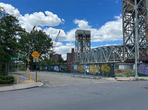
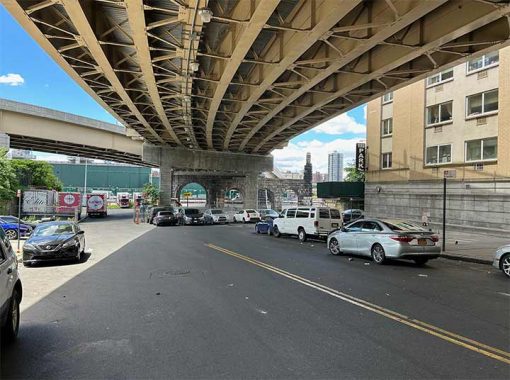
A block to the west is the shortest stub of Park Avenue, which follows the Metro North Harlem Line between Grand Central Terminal and Fordham Plaza. Below 96th Street, the avenue is a luxury address. In the Bronx it is lined with warehouses and small manufacturers. The lift drawbridge next to this dead-end was installed in 1956, replacing an older swing bridge.
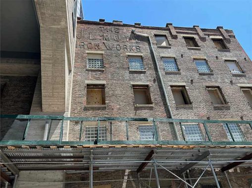
Mott Iron Works appears in the bricks of the old building that is now sandwiched between the high-rises, honoring the man who founded this neighborhood.
Another side of this building has fading letters that I could not identify. The stairs here lead to Bankside Park, a privately-owned public space with unique light fixtures. What genus and family would Kevin assign to it? Linnaeus to botany is Kevin Walsh to lampposts.

A meandering path floors the water’s edge at this post-millennial park. Canopies resembling train station platforms acknowledge the single freight track that follows the shoreline. Trains here run very rarely, so most of the noise here is from the highway on the opposite side of Harlem River and Third Avenue Bridge. In the future, this park will be linked with other new waterfront parks on the Bronx side of the Harlem River, creating a continuous green corridor running north to Van Cortlandt Park.

For now, Bankside Park’s eastern entrance is at Lincoln Avenue, which lines up with Manhattan’s Second Avenue as the northern extension of the city’s street grid. The former ice factory at 20 Bruckner Boulevard is topped by an ad for the ride-share Uber. It has a long history of hosting advertisements visible to drivers on the Triboro Bridge and Harlem River Drive. Business Wire has the full list of ads that have stood atop this building, starting with Ruppert’s Beer in 1932, followed by gasoline, three cigarette makers, the History Channel, and iHeartRadio. Uber secured its right to the city’s largest outdoor billboard in 2021. The building was redeveloped as the Dream Charter High School in 2023, in which classrooms have exposed brick walls, interior murals, and high ceilings. In regard to its appearance, it is like no other school.

At Lincoln Avenue, the dead-end crosses the freight track. Completed in 1998, the 1.9-mile Oak Point Link connects the Hudson Line with the Northeast Corridor, with the Harlem River Yards and Oak Point Yard on its route.
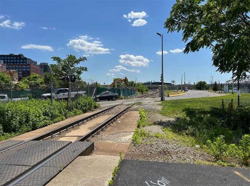
As Mott Haven slowly gentrifies and becomes less industrial, the Harlem River Yards are not expected to change. It was designated by the state as an industrial park in 1991 with a 99-year lease. Its long history extends back to the late 19th century, when it was a passenger and freight terminal at a time when only the New York Central lines had access to Manhattan and its Grand Central Terminal. When the Third Avenue El was extended into the Bronx in 1886, the Willis Avenue station offered transfers to the train line serving eastern Bronx, New Rochelle, and Rye. It closed in 1924 after a new station on 133rd Street (Bruckner Boulevard) opened.
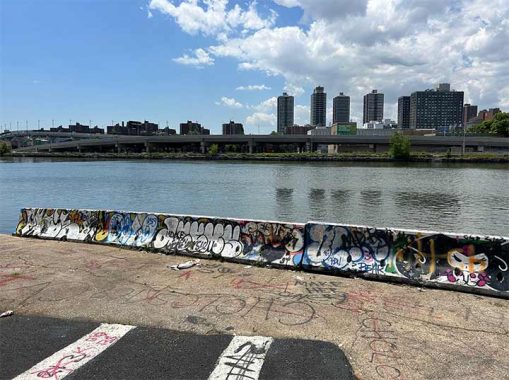
Looking south from Lincoln Avenue, the Taino Towers of East Harlem dominate the skyline. They honor the indigenous people of Puerto Rico. Completed in 1979, most of its early residents were low-income people from the island. I can imagine this shoreline point developed for boat access or a FerryNYC dock. Across the river is where Harlem began, a story that I reported in 2020. In this vicinity, Jonas Bronck established his farm in 1639. It was a sizable property with indentured servants growing tobacco, wheat, rye, barley, and malt. Bronck died four years later but his eternal gift to this borough is its name.
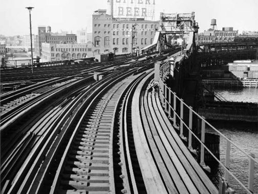
This spot had a double-decker swing drawbridge that carried the Second Avenue and Third Avenue elevated lines. It had sidewalks for pedestrian access, too. But after the last train ran here on May 12, 1955, the bridge was demolished. Promises to build a Second Avenue Subway and extend it into the Bronx have yet to materialize. In this undated photo, Ruppert’s Beer is advertised to commuters, meaning that this photo was taken before 1952.
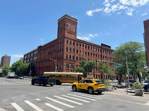
At the corner of Bruckner Boulevard and Lincoln Avenue is a non-operational clocktower, which serves as the logo of the student-run Mott Haven Herald newspaper. This building was completed in 1888, serving as the factory for the Estey Piano & Organ Company. At the time there were other piano manufacturers in Mott Haven that rivaled Steinway in Queens. The clock doesn’t work but this building will always be here because it is a designated city landmark. The last piano was made here in 1929.
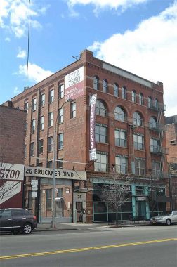
Across the street, 14 Bruckner Boulevard is the former Bollerman-Kroeger piano factory. In 2007, Ron Bollerman, a great-grandson of the company’s founder, shared some tidbits about this building with readers. Down the block at 26 Bruckner is an apartment building branded as Piano Factory. On its side wall is a fading ad for Behning & Sons Piano Company. With so many historic buildings on Bruckner relating to one instrument, around 2015 developer Keith Rubenstein sponsored a billboard declaring a new name for Mott Haven- the Piano District. It was met with a Bronx cheer from activists, residents, politicians, and artists including rapper Swizz Beatz, who was raised nearby in the St. Mary’s Park Houses.
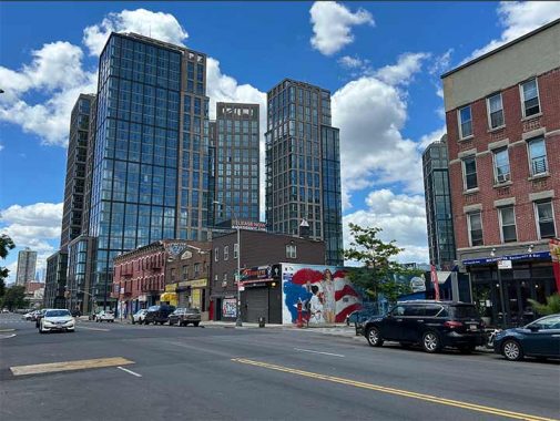
One block up from the clocktower at E. 134th Street is an angelic mural of Jennifer Lopez with a Puerto Rican flag and the elevated 6 train. Raised in the Castle Hill neighborhood, her first album On the 6 pays tribute to the subway train that took her to dance classes in Manhattan. Since then, she’s become an A-lister in dance, acting, and singing, plus four marriages as of this date. Note how the post-millennial towers are looking down at the old walk-ups. Their days are numbered, and this mural will go down with them.
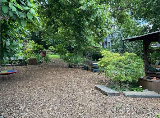
On a narrow shoulder space between E. 134th Street and Major Deegan Expressway is the Maria Sola Green Space, named for the wife of a past gardener, Jose Rodriguez, a former NYC Parks worker and Golden Glove boxer, who started cultivating in this space in 2003, with permission from the DOT. The highway is designated as Interstate 87, which has its start in Mott Haven and it runs north for 333 miles to the Canadian border.

At 346 E. 134th Street, two grotesques guard the entrance to this walkup. Such craftsmanship was common in tenements of the early 20th century. Sadly, today’s low and middle-income buildings are nothing more than boring glass and brick boxes.
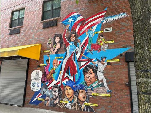
To the east on E. 134th Street is another beautiful mural honoring Puerto Ricans in art, sports, music, and activism. In the center is La Borinqueña, a comic superhero inspired by the island’s indigenous name.
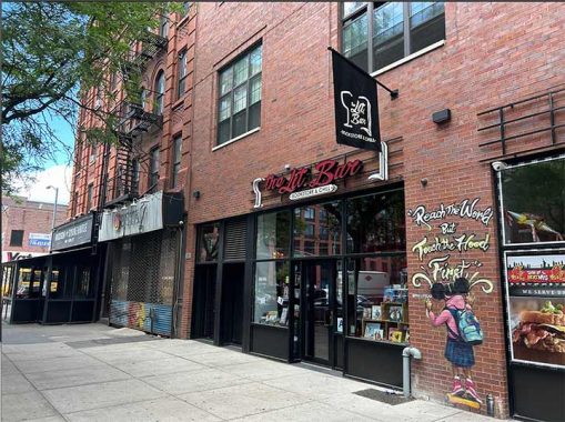
Alexander Avenue got its name from a family that owned land here in the mid-19th century. It was laid out in 1891, serving a prestigious address in the early 20th century. Irish Fifth Avenue and Doctor’s Row were its nicknames. On the map, it lines up with Manhattan’s First Avenue. It is the address for a rare indie bookstore, The Lit. Bar, which opened in 2019. Its owner Noëlle Santos is also a Bronx native who fought to ensure that this borough would have at least one functioning bookstore.
The apartment building at 70 Bruckner Boulevard was completed in 2010 on a curve-shaped property facing an empty lot across the street. Look at an old map and you can see that the curve was the route of the Third Avenue El as it went south and then turned to cross the Harlem River. After its abandonment in 1955, the tracks were removed and the right-of-way was sold to developers. There was a time when elevated tracks were as visible throughout Manhattan as they are today in downtown Chicago. Third Avenue El was the last such line running in Downtown and Midtown.

A look back on Google Street view from 2009 shows a bus repair garage at this site. The elevated tracks ran above the driveway here. After 1955, the section north of 149th Street continued to operate as a shuttle to Gun Hill Road. Its last train ran until April 29, 1973, when that segment was also abandoned and demolished.
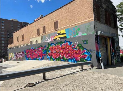
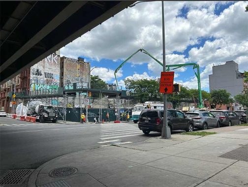
Graffiti can be ugly but with permission and time, a “writer” can create elaborate designs of slabs (large letters) and tags (small letters) as seen on this building next to the undeveloped route of the Third Avenue El.
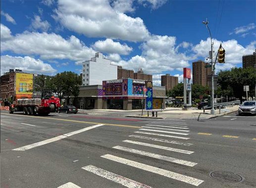
The global fast food chain McDonalds used to be known for having identical restaurants throughout the world but in this century it redesigned many of them to look like coffee shops and include creative elements. The Mott Haven franchise has tropical-theme murals by artist Carla Torres in 2023.
Across the street from this McDonald’s is the Willis Avenue Bridge, whose approach ramps were replaced in 2011 along with the drawbridge. Underneath it are sodium lamps and stone arches that stand as historical elements from the original bridge.
At the corner of Willis Avenue and Bruckner Boulevard is a fading ad that will soon disappear behind a new building. “Nobody Beats…” it reads. Could it be The Wiz, the electronics retailer that operated from 1977 to 2003? Perhaps Frank Jump knows more about it.

When Casimir Pulaski‘s name comes to mind, usually we think of Greenpoint. But there’s another historically industrial area where the Polish general’s name relates to a bridge. Pulaski Park on Bruckner Boulevard was acquired by the city in 1904 during the construction of Willis Avenue Bridge. In 1930, it was named for Pulaski, who fought and died fighting against the British in the American Revolution. Mott Haven never had a significant Polish community so perhaps the choice of name was simply to honor a patriot without a specific connection to the neighborhood. When Percy Loomis Sperr documented it in 1937, it was entirely paved. It remind that was until 2021, when it received a green transformation, living up to its name as a park.

As with some of my previous essays, a map tour into the past reveals how much of Mott Haven has changed. This Robinson property survey from 1908 shows Mott’s Iron Works where Bruckner Boulevard begins at Third Avenue. Behind the factory was Mott Haven Canal, which I’ve documented in detail in my Hidden Waters Blog.

The Bromley atlas from 1921 shows two roundhouses on the site of today’s luxury high-rises, multiple piano factories, the tracks of the Harlem River Yards, and Third Avenue El. Jordan Lawrence Mott would not recognize the Mott Haven of today, with the lone exception of the factory amid the condos that carry his name in bricks.

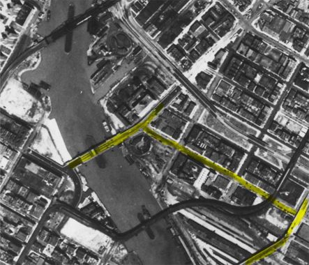
Looking at Mott Haven from the city’s 1924 aerial survey as seen in this Then & Now interactive map published by the city, I highlighted Third Avenue, Willis Avenue, and Bruckner Boulevard. Mott Haven Canal appears in the northwest corner, a tight waterway that would be filled by the end of that decade. Third Avenue El crossed over the freight rail yard and then turned north, running on a narrow line between the brownstones and tenements.
By 1951, the canal was reduced to a small indentation on the shoreline. Harlem River Drive was not yet built but the Major Deegan Expressway eliminated entire blocks of Mott Haven. Third Avenue El would run here for another four years and would then become a memory of transit policy shortsightedness. It’s easier to abandon and remove a transit line but so difficult to build a new line in its place.
Kevin has been to Mott Haven in the past, in 2018 and 2013. When he crossed five of Harlem River’s bridges in 2009, he wrote in detail about the former piano factories on Bruckner Boulevard.
You can learn more about Mott Haven by visiting each of the hyperlinks posted in the essay above.
Sergey Kadinsky is the author of Hidden Waters of New York City: A History and Guide to 101 Forgotten Lakes, Ponds, Creeks, and Streams in the Five Boroughs (2016, Countryman Press), adjunct history professor at Touro University and the webmaster of Hidden Waters Blog.
As always, “comment…as you see fit.” I earn a small payment when you click on any ad on the site. Take a look at the new JOBS link in the red toolbar at the top of the page on the desktop version, as I also get a small payment when you view a job via that link.
7/7/24
12 comments
What a difference fifty years makes. I was employed in that area from 7/72-4/74, at 149 St & Third Ave. It was known as “the hub”. On Third Ave. were banks & lunch counters. 149 St ran uphill to the Grand Concourse where NYS Supreme Court was located. Going downhill was the newly rebuilt Lincoln Hospital & many local businesses that served those who like me worked in the area but didn’t live there. I recall a family-owned Italian restaurant that featured a great, & very affordable luncheon menu; it had a large & loyal customer base.
Further along on Third Ave. was the neighborhood’s only department store, Hearn’s that was slowly dying before the neighborhood’s eyes. Due to unrealistic rent control schemes tenements became targets for arson schemes & by the time I was ready to leave for greener pastures at 2 World Trade Center in the spring of 1974, the south Bronx resembled immediate post-WW2 Berlin. As for the future of this area & urban America in general: “Que Sera, sera”. Wake up & start voting again, NYC. Voter apathy has given you a self-serving political rouges gallery. So sad.
As always an excellent article by Sergey,all the links are also interesting.
I know some of these when I get off the Major Deegan Expressway to get to Third Avenue Bridge for the FDR Drive, though seeing these newly-built apartments does show that not even Mott Haven is immune to gentrification.
“Before you call Chuck Norris or Charles Bronson as your bodyguard for this tour,”
.
Being 84 years old Chuck Norris probably is past his effective days as a bodyguard. And Charles Bronson *definitely* is!
Bruckner Boulevard was originally called Eastern Boulevard from when it opened in the late 1800’s until 1942 when Borough President Henry Bruckner passed away and within 3 months the boulevard name changed to honor his memory.
People there set fire to the buildings in which they lived so they could be put at the head of the
waiting list for public housing.Only problem was,they then had to wait behind all the other people
whose buildings had burned down,deliberately or otherwise.
Borough President Henry Bruckner made his money in beer and soda with his brothers, his best selling soda was called “u know it,”
While the Oak Point Link is only 1.9 miles, it is of outsized importance as a rail link to help reduce truck traffic in New York City and on Long Island. This link allows freight trains, with box cars or single-height containers, to easily enter the Bronx (including for the Hunts Point Market) and connect to the Long Island Railroad via the Hell Gate Bridge. An observant eye will see where parts of the line are new, and where road bridges were raised and re-constructed to allow these higher freight cars to pass under. Before this, most rail freight was floated across the Upper New York Harbor from Staten Island to Brooklyn. The rest required small trains to take a slow and torturous route that twisted through the Bronx. If this link were used to its fullest potential, it would remove many thousands of truck from the New York City / Long Island area.
Does anyone remember the “antiques row” on Bruckner and some of its side streets? I first went there in 1991 and there were a number of stores then, but this number has dwindled to zero by now if I’m not mistaken. This is general trend I’ve seen in other former antiques destinations – in Maryland, for example. Does anyone know when the Bruckner antiques row got its start?
I do. There was a name for that section of stores during that period which has eluded for sometime now. I believe this was a result of the large number of piano manufacturers that established business during the mid 1800s in that area specifically.
Thanks for this. It reminded me of when moved to Connecticut from St Louis in 1968 I took Bruckner Boulevard at least weekly. (Girlfriend in Queens.)”, I don’t remember much except
1 there was a traffic circle near a drive in theater near (I think) the northerly end of the Boulevard. The traffic around that circle was always impossible and the sheer size of it was astonishing to me as a newbie to the City. I haven’t made that drive in years (nor have I seen the girl) but I believe both the drive-in and the traffic circle must be long gone.
2. Where the southerly end of the Boulevard joined what is now 695, there was a nasty, sharp left curve onto the expressway ramp. If you didn’t know it was there – as I didn’t my first time – making that turn was an unexpected white-knuckler.
Ah, the good old days.
Yes, John, you’re correct. The traffic circle was replaced by an extension of Brukner Blvd in 1971 & it was a welcome improvement. I wish it had been completed while I was still attending Queens College. Better still, I departed the Evil Empire State in 2005 (relocated to AZ) & I vow never to return.