
By SERGEY KADINSKY
Forgotten NY correspondent
On a recent walk on 12th Street, a block from the world’s largest used bookshop, I passed by a scaffolding-clad public school building dating to 1855. Its design is reminiscent of two schools from that time period which I’ve previously documented: Grammar School No. 55 that stood on the site of Chelsea Green, and Primary School 14 on the site of Catherine Street Shelter. Besides its landmark status, this former school is today the office of the Police Athletic League. Its history is documented in detail by Daytonian in Manhattan blogger Tom Miller.
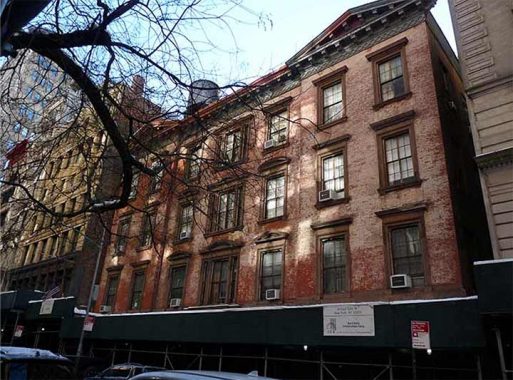
I then looked for this historic building on old maps of Manhattan and noticed a forgotten grid-defying cul-de-sac on the property next to it, Union Court.

The Perris Map from 1857 (north is at the bottom) shows Union Court taking a diagonal jog from University Place, running behind the public school. Other diagonal property lines on this map align with Broadway, Manhattan’s best-known grid-defiant road. No photos exist of Union Court and I can imagine it as a set of rowhouses akin to nearby MacDougal Alley and Washington Mews.

On the 1867 Dripps atlas, I highlighted the public school on East 12th Street. The tracks on Fourth Avenue, University Place, and 14th Street are horse-driven streetcars. Dotted lines indicate properties that predated the imposition of the urban grid. Union Court lined up to those old property boundaries.
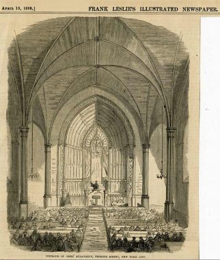
Another curiosity on E. 12th Street is a “Hebrew Church.” Built as a Baptist church, this property was purchased by Temple Emanu-El in 1854 as it gradually moved uptown from the Lower East Side. The city’s oldest Reform synagogue moved again in 1868 to 43rd Street, and to its present location on E. 65th Street in 1930. Breaking with centuries-old Orthodoxy, Emanu-El allowed for mixed-gender seating, musical instruments on the Sabbath, and modified prayer services.
Into the late 19th century, practitioners of Judaism were interchangeably known as Hebrews, Israelites, and Jews. Gradually the last term became universal in identifying this group. During this time it was also common for rabbis and cantors to use the honorific Reverend, which later became associated solely with Christian clergy.
Also on this map is the Academy of Music at 126 E. 14th Street. This opera house was a precursor to Lincoln Center. It was demolished in 1926 in favor of the Con Ed headquarters.
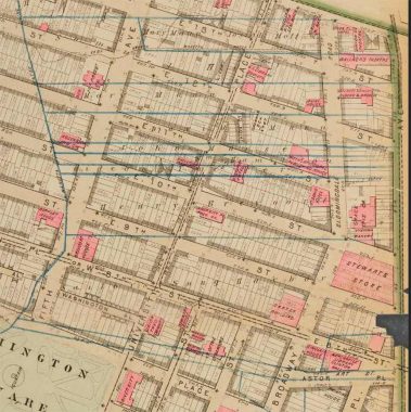
In the 1879 Bromley atlas, the pre-grid property boundaries appear in blue, stretching between Fourth Avenue (Bowery’s northern continuation) and the meandering course of Minetta Creek, the famed waterway of Greenwich Village. Alexander T. Stewart made his wealth in the department store on this map, financing a railroad in eastern Queens and Garden City on Long Island. At the time, Broadway north of E. 10th Street was known as Bloomingdale Road, running on this name into the Upper West Side. Across the street from Stewart’s Store is the historic Grace Church whose presence interrupts E. 11th Street.

The 1893 Robinson & Pigeon atlas was the last to show Union Court as the neighborhood south of Union Square was now densely urbanized with hotels on Broadway, theaters at Union Square, and industrial lofts on the streets.
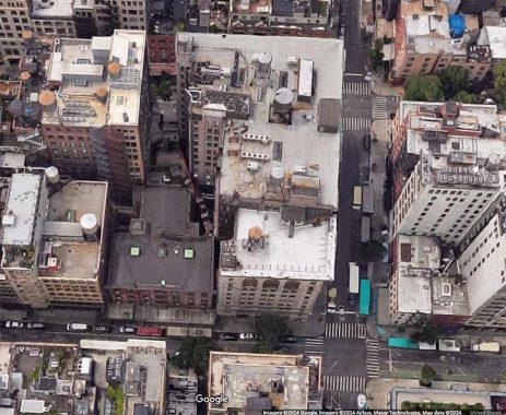
In 1899, the corner of E. 12th Street and University Place received a 10-story neoclassical office building designed by William Hazlett. In the second half of the last century it was known as the TWUA Building as it had the offices of the Textile Workers Union of America. The building next to it that wiped away Union Court was completed two years later by Goldwin Starrett, whose firm specialized in department stores and office buildings. An aerial view from Google Maps shows a property line behind the building and the rooftop running askew to the street grid, preserving the outline of long-forgotten Union Court.

Most of the property lines behind the buildings here conform to the street grid, and those that deviate predate the grid. The tower erected at 21 E. 12th Street in 2018 has one side that predates the grid. The building that preceded this tower, Brevoort Garage, was named for a prominent family that owned land here into the early 19th century.

One reminder of this neighborhood’s textile-making past is a fading mural ad on 35 E. 12th Street, an office building whose ground floor has The Village Temple, a Reform Jewish congregation that began in 1948 at the now-gone Brevoort Hotel four blocks to the south.

I walked into the lobby hoping to have access to the backspace or rooftop. No luck, but a map of the building’s interior on the stair door also shows the diagonal line relating to Union Court.
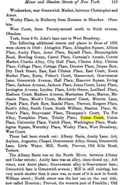
Over the years, Kevin Walsh has done Street Necrology pages for neighborhoods transformed by highways, office complexes, and urban renewal superblocks. The earliest example of a guide to the city’s eliminated streets was in the journal titled Old New York, published in 1890 by Wesley Washington Pasko. His list includes curiosities such as Cartman’s Arcade, Fisher’s Court, and Old Kiln Road.
You can learn more about the history around this forgotten dead-end by visiting each of the hyperlinks posted in the essay above.
Sergey Kadinsky is the author of Hidden Waters of New York City: A History and Guide to 101 Forgotten Lakes, Ponds, Creeks, and Streams in the Five Boroughs (2016, Countryman Press), adjunct history professor at Touro University and the webmaster of Hidden Waters Blog.
As always, “comment…as you see fit.” I earn a small payment when you click on any ad on the site. Take a look at the new JOBS link in the red toolbar at the top of the page on the desktop version, as I also get a small payment when you view a job via that link.
11/3/24


3 comments
Wesley Washington Pasko, 1890, “Cartman’s Arcade”?
I guess he would know, so I respect his authoritah…
You can see want-ads as late as 1895 referencing “Union Court,” such as the one in the Times for November 28, 1895, page 6. Around this time, there are a lot of ads in papers for cooks and laundresses for addresses at Union Court, which gives credence to your comment regarding the growth of hotels in the area.
Having said that, of course, I found another ad in the World from June 12, 1896, advertising a position for a paper hanger, “University Place & Union Court.” The July 1 1899 Sun notes that a “new mercantile building,” possibly the Hazlett building you refer to, was sold for $180,000.