


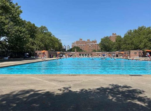
FOLLOWING up on John Jay Park, 33 blocks to the north on the East River shoreline is another park named after a Founding Father, carved out of the street grid with its own outdoor pool. Thomas Jefferson Park opened in 1905 to serve the residents of East Harlem, which at the time were mostly Italian immigrants living along Pleasant Avenue to the north of this park. As with John Jay, this park underwent many transformations since its development, most recently with the skateboarding area added in 2017.
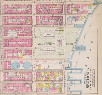
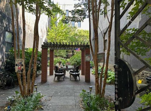
The placement of the landmarked rec center and pool in 1940 fits within the park’s geometry, which has two long fields on its north and south sides, with the pool between them. On this map from 1911, the two genders played on separate fields as was proper in those days. The pool was built on the mall separating these fields. The portion of Pleasant Avenue south of the park was later absorbed into FDR Drive.
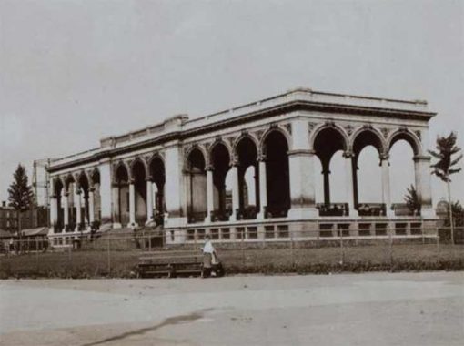
Closer to the shoreline, a classically-inspired pavilion served as a stage and bathhouse. Other parks from this time period had similar beaux arts structures with columns, as seen today at Tompkins Square Park, Union Square Park, and McGolrick Park. It was demolished when the pool was built.
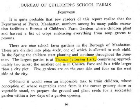
In the first half of the 20th century, the Parks Department had the Bureau of Children’s Farm Gardens, which set aside parkland for public school gardens. At two acres, Thomas Jefferson Park had the largest agricultural classroom in Manhattan.
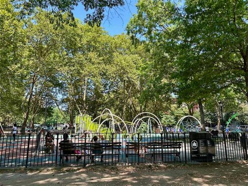
The approximate site of the children’s farm is a playground today. The loops of the play equipment evoke the vines of the site’s past. As demographics change, parks adapt to their users. At its southeast corner, this park had bocce courts that were eliminated in favor of basketball courts as the local Italian community moved away.

Near the site of the pavilion, the park has two public artworks, Tomorrow’s Wind by Melvin Edwards, and El Arbol de Esperanza by L. Brower Hatcher. The latter was installed in 1995 and its name is a nod to the neighborhood’s Puerto Rican community, which moved in as children of Italian immigrants were moving out. The park also appears in this 1935 illustration by Ashcan artist Jerome Myers.
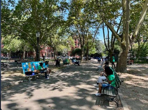
The benches near the park’s north entrance were designed by students of PS 206M. Titled Benchmarks, they were on display during the summer of 2025, in partnership with the Center for Educational Innovation and teaching artist Maria Luisa Portuondo Vila.
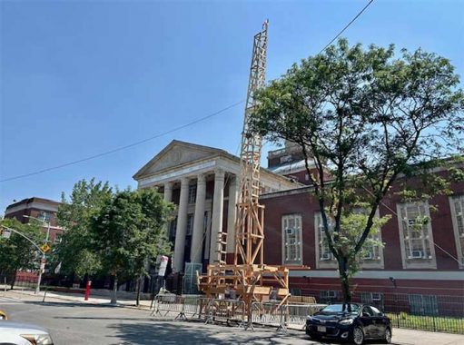
To the north of the park, where Pleasant Avenue takes the route of Avenue A on the Manhattan grid is the landmarked Manhattan Center for Science and Mathematics, which was built in 1942 as Benjamin Franklin High School. As a rule, the city’s high schools used to carry the names of their respective neighborhoods, or famous Americans, but now many of them have long-winded names relating to their academic specializations, or renamed as campuses hosting smaller high schools within their buildings. A reminder of its original namesake is a profile relief of Franklin on the pediment.
The scaffolding in front of the school is for the East Harlem Giglio Feast, a summer tradition that began in 1908. The parade begins at Our Lady of Mount Carmel, the neighborhood’s historic Catholic shrine church.
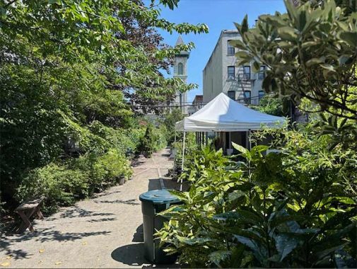
Perhaps it is counterintuitive to see a pocket park across the street from a superblock park. Rodale Pleasant Park Community Garden was developed in the 1990s on a vacant lot by neighbors involved in urban agriculture. Its namesake is the Rodale Institute, an agricultural education and research nonprofit.
Two buildings away from it is another green space, Family Garden by Tiffany & Co. Developed by the New York Restoration Project and funded by the upscale jewelry retailer, it also takes up a city-owned vacant lot.
To the south of Thomas Jefferson Park, a sizable Con Ed operations center has a long history of utility usage, having hosted twin gas holder tanks in the first half of the last century. Once a defining skyline feature for many neighborhoods, the city’s last pair in Greenpoint was imploded in 2001.

A map of the neighborhood from 1867 shows the Harlem Gas Works. The site of Thomas Jefferson Park was formerly the property of James Roosevelt, great-grandfather to FDR, whose name was bestowed on the shoreline highway bordering this park. Similar to how John Jay Park is located a couple blocks north of Saw Kill, Thomas Jefferson Park is four blocks north of E. 107th Street, where Harlem Creek flowed into the East River. Both streams were buried by the northward growth of the city, with the constructed lakes of Central Park as their only visible remnants.
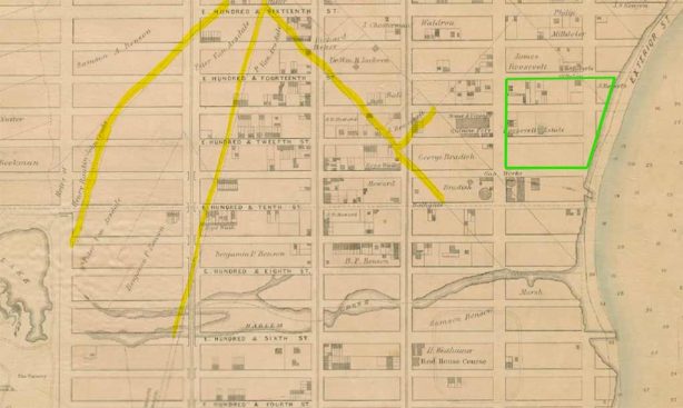
Another family on this map were the Bensons, descended from a Danish settler. Like many of their neighbors, their farm relied on slave labor. In 1793, Lanaw Benson was freed and purchased a four-acre property on what became the northern tip of Central Park, a rare Black woman who owned land.
Finally, I highlighted the pre-grid roads on this map, from left to right: Eastern Post Road that ran from lower Manhattan to Boston, its parallel Old Harlem Road, and Roosevelt Lane that connected these roads to James Roosevelt’s farm.
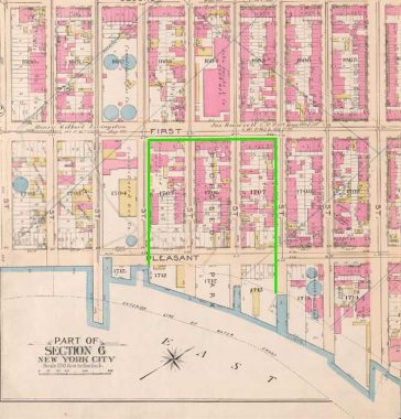
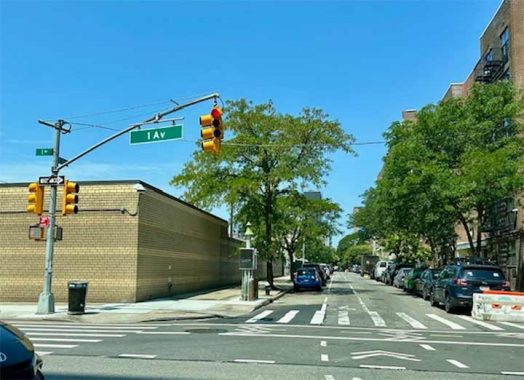
Avenue A used to have three segments separated by indentations in the shoreline: East Village, Yorkville, and East Harlem. North of 14th Street, portions of it became Asser Levy Place, Sutton Place, York Avenue, and the segment in East Harlem was renamed in 1879 as Pleasant Avenue. On this map from 1897, the outline of the “proposed park” is marked in green. The condemned blocks contained tenements and industries such as stoneworks and coal yards. The famed urban photographer Jacob Riis documented the transformation of this site into a park.
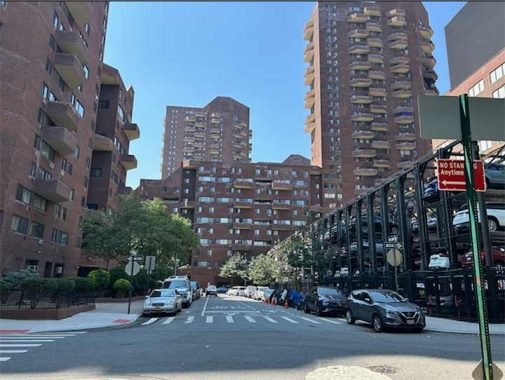
Between First Avenue and the shoreline, a midblock street runs between a storage warehouse and the towers of 1199 Plaza. City planning maps show it as “A New Street,” and Google Maps agrees, although the online DOT map shows it as part of E. 110th Street. The generic designation first appeared in 1970, when four city blocks were condemned to make way for 1199 Plaza, a co-op built by the influential city healthcare workers union.

This unsigned one-block street first appeared on a city planning map in 1970. It connects a stub of E. 110th Street with this dead-end of E. 111th Street. If city mapmakers have a sense of humor, they could rename it Negative Half Avenue to mimic 6 1/2 Avenue in Midtown. But seriously, as politicians like to rename streets for deserving local individuals, I’m sure that it’s a matter of when, not if, before this one-block road is given a name. As generic names are concerned, Kevin documented every Marginal Street in the city, and the oldest New Street.
These towers are among a handful of developments sponsored by labor unions, some of which are subsidized by the state’s Mitchell-Lama program. Other examples include Electchester, Concourse Village, Big Six Towers, Amalgamated Housing, and Penn South, among others. Today, 1199 Plaza carries the name East River Landing.
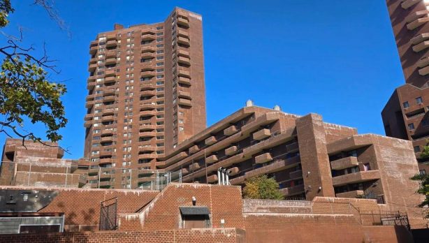
Designed by The Hodne/Stageberg Partners, the four brutalist high-rises are designed in a U shape, with concrete courtyards inside them. Although they take up a superblock, the buildings preserve the visual corridors of the demapped streets. At the time of the co-ops’ completion in 1975, residents anticipated taking the Second Avenue Subway, following the 1972 groundbreaking on the tunnel. But the city’s financial crisis that year froze the project, which will eventually have trains running from 125th Street to the Financial District. At present, this subway line runs only between 63rd and 96th streets.
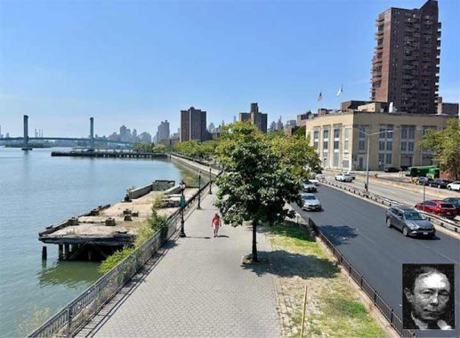
The section of the East River Greenway connecting Thomas Jefferson Park to Carl Schurz Park is named Bobby Wagner Walk. He was known by his nickname to avoid confusion with his grandfather who was a Senator, and his father who was a mayor. This Wagner (1944-1993) served as a deputy mayor, president of the Board of Eucation, and chairman of the city planning commission. The last role was his favorite, as it involved redesigning parks and streets.
To avoid confusion with the highly divisive RFK Jr, perhaps the state can rename the nearby RFK Bridge as the Bobby Kennedy Bridge (as RFK Jr’s father was affectionately known), although I’m always going to call it Triboro. As with the Robert F. Wagners, there are three generations of RFK, although the youngest one is not in politics. He’s an actor.
[The most famed Bobby Wagner in 2025 is probably the Washington Commanders linebacker. –Ed.]
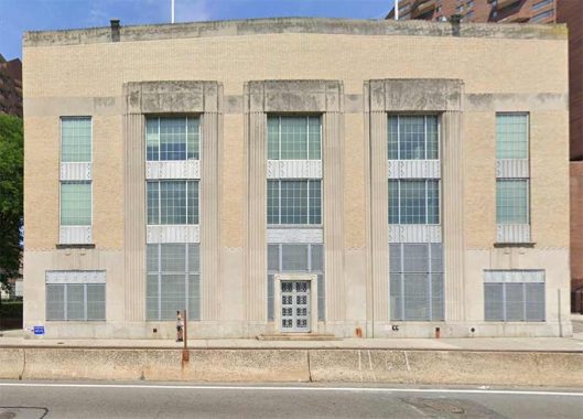
Enveloped by East River Landing is an Art Deco building hiding a utility purpose. Beneath the Broadway font naming the Department of Sanitation, this is the Manhattan Grit Chamber, where solid materials are removed from Manhattan’s sewage flow before it continues through a tunnel to the treatment plant on Wards Island. Built in 1937, it was a New Deal project with a sense of design that is worthy of landmarking. Its sister facility in Mott Haven has this designation.
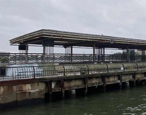
A final municipal item close to Thomas Jefferson Park is the 107th Street Pier, which is slated for a redesign. Initially built for sanitation, it was repurposed in 1931 as a park. Since the turn of the millennium, this pier fell into disrepair and was fenced off from the public. The redesign will construct a new pier with accessibility, better views, and public art.

This country’s third president is also honored with a street on the Lower East Side, an avenue in Bushwick, and another on Staten Island, a high school in East New York, elementary school in Flushing, and Jefferson Market Library in Greenwich Village.
As presidents and city parks are concerned, Jefferson shares company with Washington, Madison, Jackson, Van Buren, Lincoln, Grant, Cleveland, McKinley, Theodore Roosevelt, Wilson, Harding, FDR, JFK, and Carter.
On one of his visits to the city, Jefferson wrote to his daughter Martha, “I find it difficult to procure a tolerable house here.” His longest stay in New York was only six months.
You can learn more about the history of this neighborhood by visiting each of the hyperlinks posted in the essay above.
Sergey Kadinsky is the author of Hidden Waters of New York City: A History and Guide to 101 Forgotten Lakes, Ponds, Creeks, and Streams in the Five Boroughs (2016, Countryman Press), adjunct history professor at Touro University and the webmaster of Hidden Waters Blog.
Check out the ForgottenBook, take a look at the gift shop. As always, “comment…as you see fit.” I earn a small payment when you click on any ad on the site.
8/2/25
7 comments
People think of Avenue A as only in the East Village. I read a good bio of Stephen Crane, but it was marred because the author assumed that when Crane mentioned Avenue A in his sensational social realist novel Maggie, A Girl of the Street, that Crane was talking about the Lower East Side. He was not, he was actually talking about the Sutton Place area, which was then a slum.
The Rodale Institute’s founder was health food guru J.L. Rodale, who popularized the term organic farming. In 1971 he was being interviewed on the Dick Cavett show when he made a strange sound and his head leaned forward. Cavett said “Are we boring you, Mr. Rodale?”
Bored literally to death, actually.
Today Jefferson would say “I find it difficult to procure an affordable
apartment here”
And also, not to be confused with Robert Wagner the actor, whose life and career with always be overshadowed by the untimely death of his wife Natalie Wood.
In May 1958 Jefferson Park, an East Harlem teen youth gang known as the Red Wings fatally beat a 25 year old man who was innocently sitting on park bench. The crime attracted much media attention. In the summer of 1959, after a much-publicized trial, five young men were sentenced to prison; and two more 16 year olds were sent what was then called reform school.
I’m surprised that a local civil rights activist hasn’t demanded that the parks name be changed since Jefferson was a slaveowner.
When the current five-borough City of New York came into being in 1898, there was still strong attachment to the old villages and towns. In Queens, the high schools that were built were situated in, and named for, the old municipal towns and cities. That brought us Flushing, Jamaica, Newtown and Long Island City High Schools. As the population grew and additional high schools were built, they, were given more localized community names, like Bayside High School or Richmond Hill High School. Later on, new schools were given names of prominent local historical individuals, like John Bowne or Francis Lewis. I suspect that practice was followed in the other boroughs, as well.