

As a rule, NYC streets are given designations, seemingly arbitrarily, by the engineer who is plotting the map years before buildings on the streets are actually constructed. In Manhattan, with the overall grid cooked up in 1811, north-south roads are numbered avenues while east-west roads are streets. In the original City of Brooklyn plan, still in place in western Brooklyn, the same situation applies, while in the Flatbush system, north-south numbered roads are streets and east-west were lettered avenues. Over the years, modifications were made, and when some of the lettered avenues received names, they became roads, like Beverley and Clarendon Roads.
In Queens, the numbered plan instigated in 1915 and then slowly implemented by 1935, east-west numbered roads are avenues, while north-south numbered are streets. But there’s a twist. There are numerous streets in between, with east-west roads designated Roads, Drives and Terraces, in that order, and north-south Places, Lanes and Courts, also in that order.
In parts of town without numbered streets, seemingly anything can go, with arbitrarily named streets, places, roads, terraces, courts, alleys, and so on. More important or busier roads are often called avenue, parkway or boulevard (especially in Queens). Terraces are generally one block long, if that much, but Richmond Terrace in Staten Island is the exception, running all along the borough’s north shore; it was named for the cliff it overlooks on its eastern end in New Brighton.
For today’s feature, though, I plan to list every street designation that’s unique and used only once. I am including, as part of this survey, streets that named by one word only, and am not including Broadway, as every borough has a Broadway (with the one in the Bronx a continuation of Manhattan’s). Quibbling can be done in Comments.
Four road designations almost qualify, but not quite. In Brooklyn, Kings Highway runs several miles between Bensonhurst and Brownsville, and even then, it’s shorter than its original length from the colonial era; and Edward L. Grant Highway was named (from Boscobel Avenue) after a local World War I casualty. Meanwhile, Union Turnpike, running from Glendale to New Hyde Park, was Queens’ only turnpike until 2005, when residents of Queens’ Floral Park pushed for Jamaica Avenue east of Cross Island Parkway to be renamed Jericho Turnpike to match the side of the street located in Nassau County’s Floral Park. Additionally, there are two paths in Brighton Beach, Brooklyn: Brighton 1st Path, a walkway, and Brighton 10th Path, an actual roadway. And, “The Boulevard” can be found in Westerleigh, Staten Island, and just “Boulevard” in Malba, Queens.
I had some fun with this page, hope you will too.


I have a fascination with the Bowery and have covered it fairly often; I last walked its route in January 2025. While most who know about it call it “the Bowery” simply “Bowery” suffices on Department of Transportation street signs.
Before Broadway became Manhattan’s signature Mother Road, the lane that would become the Bowery wound to the island’s upper reaches. It was a dirt trail etched by the bare feet and moccasins of the Native Americans before the Dutch arrived and situated their farms, which they called “bouwerij” (we get our English word “bower” from the same root) and the road was, naturally, called “the bowery road.” The Bowery’s first residents were ten families of freed slaves in about 1645.
It was extended on a winding path north to ferries crossing the Harlem River and then on to Boston. It was also extended south, in the early 1800s, to connect with Pearl Street in a section at first called New Bowery and then St. James Place.
Quibblers: a second Bowery can be found in Coney Island, presently a walkway running from West 15th Street to Jones Walk south of Surf Avenue. That one, though, is called Bowery Street.


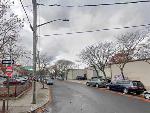
Jamaica Estates, built on the northern edge of the former Town of Jamaica in the 1905-1907 period, occupies about 500 acres between Home Lawn Street, Hillside Avenue, 188th Street and Union Turnpike. In the 1930s, it was neatly cut into two sections by the construction of the Grand Central Parkway right through it. When construction, consisting initially of Tudor-style homes on large plots (as large as 60’x105′), began Jamaica Estates was surrounded by open farms and fields, dotted by small towns and connected by wagon and farm-to-market roads, many of which developed into the pedal-to-the-metal boulevards we know today. It was also home of the Trump family, with the Cuomo family nearby in Holliswood.
The project was conceived by former NYS lieutenant governor Timothy Woodruff and railroad builder Michael Degnon, who, among many other projects, constructed the Steinway Tunnels which today connect the #7 train with Manhattan and Queens. In Forgotten NY, Degnon is a familiar figure, mentioned on FNY’s Queens railroad spurs page. Degnon is in repose at Calvary Cemetery.
I was drawn to Charlecote Ridge and its collection of Tudors. It’s the only street in NYC titled “Ridge” even though it’s not on an especially high hill. The street is named for England’s Charlecote Park, a preserve near Stratford-on-Avon, the hometown of William Shakespeare. The name always reminds me of “chocolate” or even “chalicothere,” a large extinct mammal from the Pleistocene Era.


There are three separate streets in Brooklyn, at or near the East River, running north and south in Carroll Gardens and Brooklyn Heights: Columbia Street, the longest, which goes north from Erie Basin to Atlantic Avenue; Columbia Place, one block from State to Joralemon; and Columbia Heights, from Pierrepont Street north to Doughty, where it becomes Everit Street for a block at the old Jehovah’s Witnesses Watchtower headquarters. I’ve never seen maps that indicate it, but perhaps there were once plans for a continuous road named “Columbia” along the waterfront, but because of topography, it was never fully built and instead took form in pieces.
Along is length, Columbia Heights faces a steep ridge that goes down to the river, hence its name, with Furman Street at the bottom. Brooklyn Bridge Park was built along Furman in the 2010s.

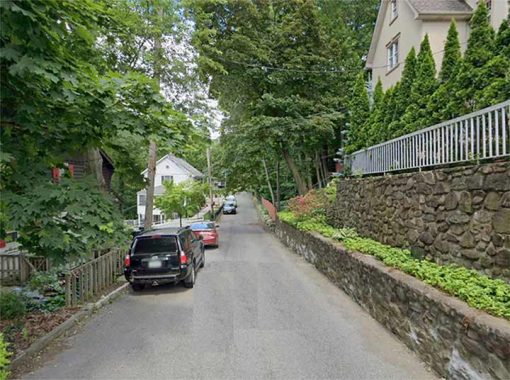
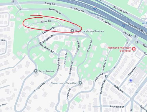
Novelists and songwriters have often mentioned getting lost in the hilly areas of western metropolises San Francisco and Los Angeles, but Staten Island has one of its very own such areas, Emerson Hill, where the meandering roads, unlit by streetlamps, dodge around one of the tallest hills on the east coast. Even I have never attempted to find my way in and out; I would need a map, a compass and a sextant. There are two ways in or out: via Douglas Road at Richmond Road and Emerson Drive at Clove Road.
The hill was named for a famed resident Judge William Emerson. Nearby Concord is a Staten Island neighborhood neatly self-contained by West Fingerboard Road, Richmond Road, Staten Island Railway, and since 1964, the Staten Island Expressway. Concord was “established” in 1845, but there had been human habitation here before that: the region had been called Dutch Farms, but it was renamed for the Massachusetts town after several famed writers from the MA town lived here, such as Henry David Thoreau and Judge William Emerson, from whom nearby Emerson Hill gets its name, the brother of Transcendentalist-philosophy writer Ralph Waldo Emerson. Thoreau tutored Judge Emerson’s children here in the spring and summer of 1843, the only time in his adult life Thoreau lived outside Concord, MA.
The “trail” is either named for the Roman goddess of the hunt, wildlife, the moon, and childbirth; or, perhaps, the wife or daughter of a developer.

There are two streets in NYC called “Esplanade” but this is the only one that stands on its own. The New York, Westchester and Boston Railroad, now the Dyre Avenue extension on the #5 train, runs in a tunnel under Pelham Parkway and is covered by a roadway with a grassy median, the Westchester Esplanade, known today as just plain Esplanade.
Per original building code, no railroads were allowed to cross Pelham Parkway at grade, so the NYW&B was placed in a tunnel when it was built around 1910. It became part of the subway system as a shuttle in 1940, and has a Pelham Parkway station using one of the railroad’s original station buildings. The Espalanade is also bisected by Pelham Parkway. It has a grassy median for much of its length, but is a regular two-lane street in its northern section running to Mace Avenue.
The original meaning of “esplanade” was a large, open, level area outside fortress or city walls to provide clear fields of fire for the fortress against incoming infantry or artillery. “Esplanade” and “promenade” are sometimes used interchangeably, but that is a mistake. A promenade can be anywhere, and it is exclusively for walking, while an esplanade is for walking but also can include large boulevards or avenues with cars.
In Brooklyn Heights, the walkway above the BQE facing the waterfront is popularly known as “the Promenade”; but its official name when built was “the Esplanade.”

The only street in NYC designated a “hill,” Fort George Hill doesn’t disappoint, especially if you have to walk or biycle south on it from Dyckman Street south to St. Nicholas and Fairview Avenues. On a few maps a couple of decades ago it was shown as a northern extension of St. Nicholas Avenue, but that didn’t stick and Fort George Hill it remains. This part of Manhattan island is so steep that the #1 train, in one of its deepest stations at 191st Street, goes to an elevated section at Dyckman.
Fort George, originally Fort Clinton, was built by U.S. patriots at about where George Washington High School stands at Audubon Avenue and West 192nd Street. Though the British eventually captured the fort, Colonel William Baxter and his Bucks County Pennsylvania militia were able to hold off British general William Howe’s troops long enough for Washington’s troops to escape to New Jersey (much of the Revolutionary War in 1776 in the immediate NYC area consisted of Washington escaping to fight again).

The histories of Staten Island street names remain unchronicled for the most part; Manhattan has its Henry Moscow (The Street Book) and Sanna Feirstein (Naming New York); Bronx its John McNamara (History in Asphalt) and Brooklyn its Leonard Benardo and Jennifer Weiss (Brooklyn By Name). Street histories of Queens and Staten Island are somewhat more shrouded.
Thus Giffords Glen, a mildly curving path between Lindenwood Road and Nelson Avenue near the Great Kills SIR station, is rather a mystery, though the “Glen” part means it was once a grassy expanse. There is a much longer Giffords Lane running north-south from Arthur Kill to Amboy Roads nearby and no doubt it’s the same Gifford, who was likely a prominent property owner in the vicinity.

Eleven lanes wide from 161st Street north to Mosholu, the Grand Boulevard and Concourse (shortened to Grand Concourse for the benefit of sign makers and cabbies) was built, from 161st Street north, in 1909 by engineer Louis Risse. In 1927, it absorbed Mott Avenue, which ran from 138th north to 161st, and the older street was widened. The Grand Concourse became the Bronx’s showpiece as the Bronx County Courthouse, Yankee Stadium, and an array of elegant apartment buildings were constructed along or near its length. The Concourse and surrounding streets are a wonderworld of magnificent apartment architecture. Most of the grand apartments were built from 1925-1940. The dominant style is Art Moderne, a streamlined style offshot from Art Deco. In that era most of the Concourse’ residents were Eastern European and Jewish, but in the late 1960s and early 1970s demographics changed, as Co-Op City near the Westchester county line was built and the overall rush to surburbia spurred a move out of the city. Today the Concourse is home to a Latino and Caribbean-American population, and the architecture is seemingly eternal.

The Harlem River Driveway today is a connecting road from Maher Circle to the Harlem River Drive proper, but it started out as the ‘original’ Harlem River Drive, long before automobiles were commonplace. In fact the word “driveway,” now used as the lane alongside private homes leading to garages, originally referred to the drivers of horses.
Recognizing the long-standing popularity of horse racing among New Yorkers, the city built a “Harlem River Speedway” along the west bank of the Harlem River in Manhattan. The 95-foot-wide dirt roadway stretched two and one-half miles from West 155th Street north to West 208th Street. Presaging the automobile parkways of the 20th century, the speedway was flanked by trees and pedestrian walkways. When it was not being used as a racetrack, the Harlem River Speedway was used as an exercise track. NYC Roads
When the Harlem River Drive was constructed beginning in the 1930s, it obliterated the old Speedway, except for a short section between what is now the Ralph Rangel Houses (Ralph Rangel, a community worker and tenant association president, was the brother of US Representative, the late Charles Rangel) and West 155th. The extant portion was renamed the Harlem River Driveway.
Here’s a 1902 film showing horses and carts making their way south on the Speedway near the bridges:


I am splitting hairs here, admittedly, but Haven Esplanade in Tompkinsville is the only occasion “Esplanade” is used as a street designation in NYC excepting when it stands alone, as in the Bronx, seen above.
A prime area for landmarking…if Staten Island could have more such designations…is Haven Esplanade, which gathers several freestanding homes around a grassy center mall between Forest and Castleton Avenues. Though the esplanade could be considered a “haven” of sorts it was actually named for Silas Nathaniel Havens (1827-1897), a prominent 19th-century New Brighton businessman. The flora in the center mall contains the usual London planes (Robert Moses’ favorite street tree; that’s why there are so many of them) plus white cedar, upright yew and several varieties of euonymus and forsythia.
Some of these homes are feasts for the eyes.

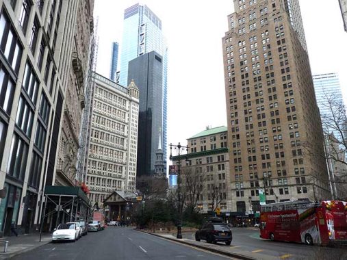
Looking south on Park Row to Broadway is the oldest remaining church building in Manhattan, St. Paul’s Chapel (1766) where George Washington worshipped and H.P. Lovecraft got married. Washington’s pew is marked — it dates back to the days when church pews had to be rented or bought. St. Paul’s has always been associated with Trinity Church, founded in the late 1600s; many streets in lower Manhattan are named for Trinity Church vestrymen. I’ve only been inside once and gotten only a couple of pictures, but in 2013 I did spend some time in the churchyard. After the 2001 terrorist attacks, the church, which suffered little damage, served as a meeting place for relief and construction workers and a place of solace for New Yorkers.
There are a number of streets called Park in Manhattan, most renamed as Park or renamed from Park. Park Avenue was once 4th Avenue for most of its length; Park Place was once Robinson Street; Park Street has since been named Mosco Street. Don’t forget Park Terrace, East and West, named for nearby Isham Park. Park Row was, until 1886, called Chatham Street, for William Pitt, the Earl of Chatham. Chatham Square, where the Bowery begins, persists. It was renamed because its lower section abuts City Hall Park.
Speaking of the Bowery, Park Row, St. James Place and the Bowery were once part of the Eastern Post Road to Boston, which was mostly obliterated as Manhattan’s street grid was built out.


Secreted deep in suburban, even semi-rural Riverdale, is Ploughman’s Bush, a mostly private driveway. For a very long time, much of Riverdale was inadequately mapped, as property owners fought to retain the private nature of the area, but Google has provided a 99% accurate street map at long last. Or is it accurate? Google marks the section between Dodgewood Road and West 247th as Ploughman’s Bush; but Open Street Map begs to differ, marking it Hadley Avenue. Only property owners know for sure.
One thing’s for sure. The dead end section at Independence Avenue and west 246th Street is marked with a brass plaque designating that as Ploughman’s Bush. In neither case does the Department of Transportation provide a street sign.
Ploughman’s Bush was given its unusual name by original landowner Robert Field in 1930. It’s unknown what the unusual name pertains to.

The term “freeway” is commonly used in Southern California in the Los Angeles metropolitan area to designate an expressway without tolls. In New York City, there’s one and only one freeway and it came to be because of a railroad.
Before 1942, the Long Island Railroad ran at grade, at level with auto roadways, on the Rockaway Peninsula between Rockaway Park and Far Rockaway, which connected with the main line through the Five Towns. That year, with auto traffic becoming common, the LIRR decided to eliminate the grade crossings and placed the railroad on a concrete-clad trestle. The railroad crossed the bay, while the Far Rock and Rock Park branches connected through a wye.
In 1950 the LIRR ended service across Jamaica Bay when a fire destroyed an ancient wood trestle. The LIRR sold the cross bay tracks to the NYC Transit Authority, which commenced service across the bay to Rock Park and Far Rock in 1956. Soon after, the connection to the main branch of the LIRR was severed, with LIRR service nosing into Queens at Far Rockway, but no further.
Meanwhile, a new roadway was constructed beneath the concrete trestle and christened Rockaway Freeway. In some spots there are lengthy stretches between stoplights and it can be a speedway as well as a freeway. When I first encountered it on a bike ride from Bay Ridge in the 1970s, the Freeway was illuminated by Belt Parkway-style “Woodie” lamps, but these were replaced by standard posts in the 1980s. Rockaway Freeway begains and ends at Beach Channel Drive between Beach 32nd and just east of Beach 116th Streets.
Check out the ForgottenBook, take a look at the gift shop. As always, “comment…as you see fit.” I earn a small payment when you click on any ad on the site.
8/28/25
9 comments
Singer Eileen Farrell, hubby NYPD officer Robert Reagan and family lived on Emerson Hill’s Diana Trail.
Near the water in Stratford, Connecticut there are two residential streets named “Lawn” after their wide grassy medians, Victoria Lawn and Margherita Lawn. I’ve never heard that street designator used anywhere else. Oddly enough, my grandparents lived on Victoria Lawn and then moved around the corner to Margherita Lawn.
In Boston there is “Fenway”, a curving thoroughfare that runs along the Back Bay Fens, near but not touching the Red Sox home venue, Fenway Park. A fen is spongy land saturated or partially covered with water.
The T, Boston’s subway system, has a Fenway stop on its Green Line D route. It is named for the thoroughfare, not the ball park.
Near where I live in Nassau County, there are two similarly-named streets, “Fenway” and “The Fenway” located respectively in the adjacent communities of Rockville Centre and Baldwin. Adjacent to Fenway in Rockville Centre you will also find the single word “Gateway” and “Intervale.”
Moving three time zones to the west, in San Francisco, there is “The Embarcadero”, a wide street that follows the city’s waterfront between the Downtown and Fisherman’s Wharf areas. That name is probably unique to San Francisco.
Grand Concourse could join the list
I added it yesterday.
There used to be an Esplanade in Manhattan Beach along the water between West End Ave and Ocean Ave. Now it is privately owned. Also, the most eastern block of what Google Maps calls Surf Ave was once called Concourse although it was never signed as such.. Today, there are still no street signs on that block to indicate it as Surf Ave.
Fascinating! And thanks, Kevin, for the creative subway tile-like graphics for the street names!
For some reason I feel as if Park Row is the only street in NYC with this name as many other cities have more of those like Chicago with Skyscraper and Printers Row to name a few, though those are mainly for nicknames and not actual streets.
Southwest Houston TX has a street named Apache Plume