

WHAT, you were expecting 42nd Street in Manhattan? That’s probably the least-Forgotten street in New York City, though it would be interesting to find “forgotten” aspects of it. I’d have to find a time when it’s mostly deserted and safe, and that would be early in the morning around sunrise, and that’s the time of day I’m achiest and groggiest. Another occasion would be just after a heavy snowstorm when no one is around, and NYC hasn’t had a heavy snowstorm for a few years.
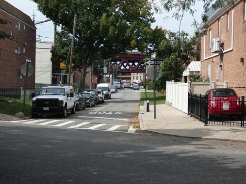
But there are other 42nd Streets in NYC, such as 42nd Street in Sunset Park and Borough Park in Brooklyn. I saw some interesting items on that 42nd Street when I walked 4th Avenue for this FNY page. There’s also East 42nd Street in Brooklyn, in East Flatbush; I haven’t walked it, but Matt Green probably has. That leaves us with 42nd Street in Queens. Just for fun I decided to walk its Astoria/LIC section north of Northern Boulevard. To get there, I took the #7 train to 46th/Bliss and walked north from there.
As a reminder, I have a lot of Galleries on this page, and the photos look small. You can get a much larger view by simply clicking on any image.
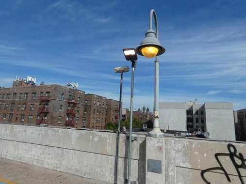
First, some infrastructure stuff. The Metropolitan Transit Authority is doing some major overdue work on its Flushing Line #7 stations in Sunnyside, completely reconstructing 52nd Street, 61st/Woodside and 69th Street, while adding elevators to others. Another aspect of this work is updating station lighting to bright white LEDs. A station renovation some decades ago added “bigloop” lampposts to the 33rd, 40th, 46th and 61st/Woodside stations, equipped with yellow sodium lamps. What I hope will happen is that the bigloops will be retained with LED replacement bulbs, but right now, there are what I hope are temporary replacements, which are just pipes with LED fixtures attached. I hope this isn’t the solution they came up with.


There’s an interesting development while stations are being reconstructed. The MTA has temporarily eliminated express service between Queensboro Plaza and Woodside, and extended the westbound platforms over the center express track. This gives passengers unprecedented space to wait here (even better, benches are provided), and gives construction workers access to the center track at Woodside. The platform extension will probably have to be repeated for eastbound platforms when the time comes, so express service likely won’t be back for over a year.


I have not spent much time in the 46th/Bliss station and so, I was previously unaware of the neat views not only of the elevated tracks west of the station but also of Queens Boulevard at street level below the tracks. It was time to descend and begin today’s hike.
GOOGLE MAP: SUNNYSIDE AND 42ND STREET
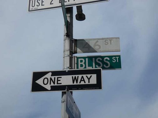
During the 1920s, Queens streets were gradually given a uniform numbering system; some neighborhoods adopted it before others, though by the 1930s, the system was fully in place. Sunnyside, especially the area around Sunnyside Gardens (see below) has partially kept the old street names not only in #7 stations (Rawson, Lowery, Bliss, Lincoln, Fisk) but also on some street signs. I was saddened to see that Queens Boulevard, one of the busiest streets in Queens, still sports numerous sun-bleached signs from the 1980s. The Bliss Street sign was added some years later.


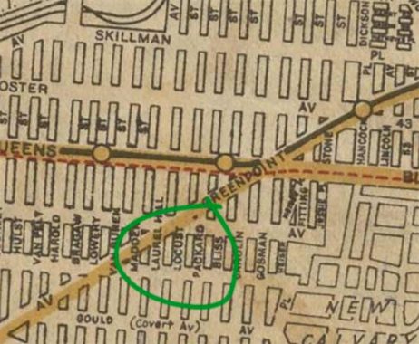
I’m only one man, as Regis Philbin used to say, but if it were up to me the side street blocks above Queens Boulevard like 45th Street, with their wondrous apartment buildings from the Deco era and other years, would certainly be worthy of Landmarks Preservation Commission recognition. 43-31 45th Street was built as Packard Towers and has some Deco touches but doesn’t ladle them on.
Why Packard Towers? When it was built, 45th Street was still called Packard Street (see Hagstrom 1922 map at left)
|
|
|
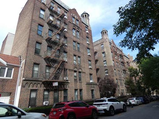
Another massive edifice, 43-22 45th Street, has a pair of “guard towers” on the roof. I wonder if anyone but the pigeons ever wanders into them.


I have referenced Child’s Restaurants often in Forgotten New York; the former chain was still active when I was a kid and perhaps even into my young adult days, since I remember a Child’s in the Times square area in the early 1980s when I was wandering around one day. I composed an entire page of former Child’s locales: most are distinctive because of their use of terra cotta to depict oceanic images like flying fish, sea horses and King Neptune. A magnificent Child’s flagship on the Coney Island boardwalk depicts hundreds of seafood images.
On that page, I noted the history of the chain:
The Childs restaurant chain was the creation of Samuel and William Childs. They revolutionized the American restaurant chain by creating a uniform look to each of their branches in order to make their restaurants recognizable. Their “brand” relied heavily on the portrayal of their establishments as sanitary, clean, and modern; the interiors were outfitted with white tile floors and walls, and even the waitresses and other workers dressed in white uniforms. The Childs brothers were also the fathers of the modern cafeteria, influencing another bygone NYC chain, the Horn & Hardart Automat. They would probably bristle if you compared them to McDonalds or Burger King, as the fare was more upscale than that, but it wouldn’t be outlandish to compare them to, say, the old Howard Johnson’s chain.
Child’s Restaurants peaked in the 1920s and 1930s, and William Childs lost control of the company after a revolt from investors after he imposed his own vegetarian preferences on the menu. Child’s became the Hotel Corporation of America in 1955 and was acquired in 1961 by the Riese Organization, which today operated restaurant chains like T.G.I. Friday’s and Applebee’s.
In 1940, the building was playing host to a number of stores including a corner drugstore prominently displaying a Rei;d Ice Cream sign. Today, it’s a Walgreen’s drugstore.


In 2020, an empty lot on 45th Street south of Skillman Avenue was converted into the 45th Street Green Space and composting site:
The property owner and the composters came together despite a rocky start. The initiative was prompted after some of the 45th Street Composters — as part of a self-described band of “guerilla gardeners” — broke into the privately-owned lot in June and took it upon themselves to use it as a composting site and garden.
Despite the trespassing episode and an initial tense exchange, the owner of the lot, BH Village LLC, was willing to set up an agreement with the composters if Sunnyside Community Services (SCS) could come onboard. [QNS]
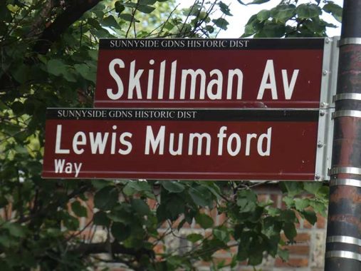


I have never lived in Sunnyside Gardens, but I always enjoy walking around in it. I had my eye on the place ever since arriving in Queens in 1993! The turn-of-the-century English Garden City movement of Sir Ebenezer Howard and Sir Raymond Unwin served as the inspiration for Sunnyside Gardens, built from 1924-1928 and located from 43rd to 48th Streets and between the LIRR and Skillman Avenue.
This housing experiment was aimed at showing civic leaders that they could solve social problems and beautify the city, all while making a small profit. The City Housing Corporation, whose founders were then-schoolteacher and future first lady Eleanor Roosevelt, ethicist Felix Adler, attorney and housing developer Alexander Bing, urban planner Lewis Mumford, architects Clarence S. Stein, Henry Wright, and Frederick Lee Ackerman and landscape architect Marjorie S. Cautley, was responsible for the project. Co-founder Lewis Mumford [the long-time architecture critic at The New Yorker] was also one of the Garden’s first residents. The part of Skillman Avenue that runs through Sunnyside Gardens has been renamed in his honor.
The design of the Gardens was novel in that large areas of open space were included in the plan. Construction costs were minimized, which allowed those with limited means the opportunity to afford their own homes. Rows of one- to three-family private houses with co-op and rental apartment buildings were mixed together and arranged around common gardens, with stores and garages placed around the edges of the neighborhood. Just about every interior window in the Gardens offers a view of a landscaped commons. A typical price for a two-story attached brick house in the development cost $9,500 in 1927!


Queen of Angels Church at Skillman Avenue and 44th Street was built in 1965 in place of the Jakob and Katherine Huther house, built before 1900 previously a small hotel used by hunters who hunted in the Sunnyside woods. It was purchased about 1900 by the Hüther family and became their general store and residence. In addition to the general store, Jakob delivered produce door to door with a horse and wagon. He used the pond on the property to raise ducks. Above the 44th Street entrance you will find the opening lines of the Magnificat (The Song of Mary). In the New Testament it is spoken by the Virgin Mary upon the occasion of her Visitation to her cousin Elizabeth.
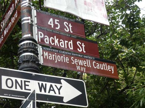
Another honorific sign is a block away at 45th Street. Marjorie Sewell Cautley (1891-1954) was a landscape architect who helped design both Sunnyside Gardens and nearby Phipps Gardens. Sewell Cautley designed the Gardens’ superblocks in which houses are oriented around central gardens and linked by footpaths. She was a protegeé of one of the first major female architects, Julia Morgan.
42nd Street
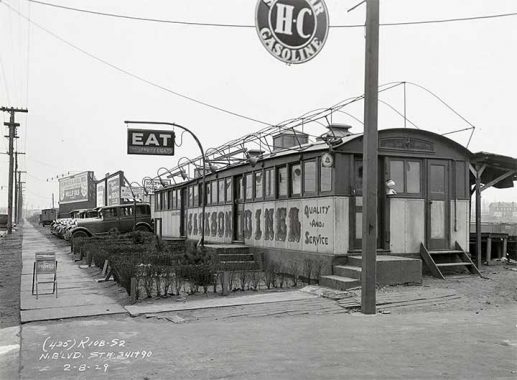
Jackson Diner, Northern Boulevard and 42nd Street in 1929. This was one of dozens, if not hundreds, of railcar-style diners scattered all over NYC. When it was built, Northern Blvd. was still called Jackson Avenue; today, only the section west of Queens Plaza still has that name.


After exiting Sunnyside Gardens, I used the 43rd Street underpass under the Long Island RR and doglegged on Northern Boulevard to 42nd Street, traveling north on it for much of the rest of today’s walk. Before the Great Renumbering of Queens 42nd Street was first Winans Street and later, 12th Avenue.
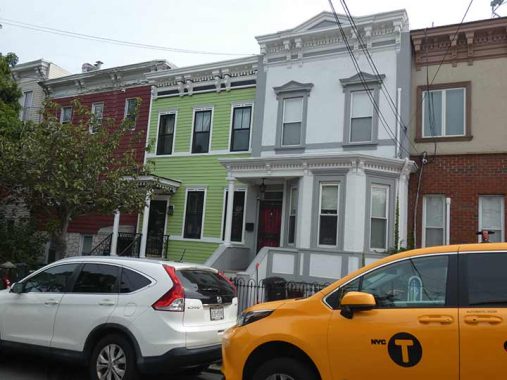
On 42nd Street north of 35th Avenue is encountered a “superblock” of attached apartment buildings on both sides of the street, no doubt built by the same developer since the buildings are exactly alike.


A variation can be found at the corner of 34th Avenue, with corner windows facing two directions. An Ecuadorian restaurant is on the corner, illustrating that you can get anything you want, culinarily speaking, in Queens.


North of 34th Avenue 42nd Street has a set of attached and standalone brick Tudors. I liked the purple door on ine of them; an adjoining cottage had a red door.
Note the Fallout Shelter sign on the adjoining apartment. “A Fallout Shelter sign marks a designated, stocked location designed to protect people from radioactive fallout after a nuclear attack during the Cold War. The black and yellow sign, featuring three yellow triangles within a black circle, symbolizes six critical aspects of an ideal fallout shelter: shielding from radiation, food and water, trained leadership, medical supplies, communication, and radiological monitoring.” Somehow I doubt an apartment house basement had all those features, even during the Cold War.
A bit of bluestone sidewalk on 42nd Street, actually more of a bluish-gray. These were often the first sidewalks built when the street was first laid out, so when you see one, it can actually date back as early as the late 1800s.


I worked (actually volunteered) at Greater Astoria Historical Society, on which I serve as a board member, between 2012 and 2018, when it was located in the Quinn Funeral Home at Broadway and 36th Street. Part of that work involved scanning and online captioning of hundreds if not thousands of postcards and photos, giving me the idea for “Forgotten Queens” (2013), a book I collaborated on with GAHS.
After finishing I would occasionally stop in at Doyle’s Tavern at Broadway and 42nd Street to meet Mitch Waxman of the Newtown Pentacle, who has since moved to Pittsburgh. The burger is, or was, exquisite at this neighborhood dive, which has been here since 1986. In 1940, it was Scanlon’s.


On the side wall on 42nd Street you can see several classic posters for Guinness.


This taco-fusion restaurant at Broadway and 42nd Street has certainly been glammed up since 2022, when it looked like this.
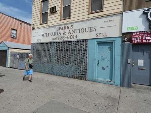
Sparr’s Militaria and Antiques, 41-15 Broadway near the Steinway Street station, has been in business since 1946 and buys and sells items like helmets, hats, medals, badges, uniforms, swords, daggers and flags, and specializes in collectibles like Japanese swords. Equipment such as multi-use knives, shovels, mirrors, commemorative plaques and mirrors are displayed in the window. Open Tuesday through Friday, 11:30-5:30.


Normally not a fan of aluminum siding but these samples, 42nd between Broadway and 31st Avenue, are a caste above what you find in say, Greenpoint.


Here’s a pair of buildings at 42nd St. and 31st Avenue you can tell had the same developer because of those circle decorations at each building”s entrance.


I’m a fan of diagonal roads that cut across grids, because more often than not, it’s a very old road that predated the overall grid. Newtown Road is just one part of a colonial-era road, Hell Gate Ferry Road, that went from the East River to the heart of Newtown (now Elmhurst) and even today can be made out on the map as Newtown Avenue, 30th Avenue, Newtown Road, Woodside Avenue and Broadway.


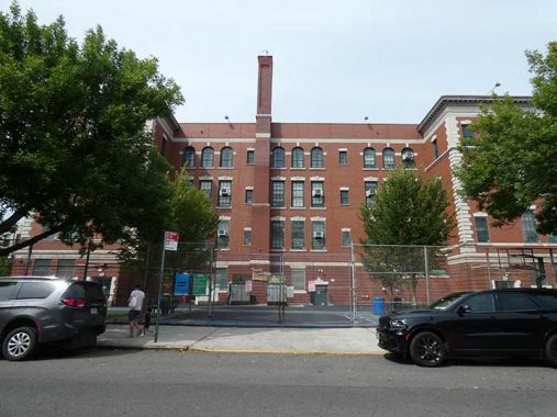
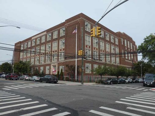
After an initial flurry of public school designs by C.B.J. Snyder and James W. Naughton, public school designs settled into a predictable, though still handsome, pattern. PS 70, 42nd Street north of Newtown Road, is one of those.


I’m unsure if these attached buff-colored apartments on 42nd Street south of 30th Avenue were indeed Gustave Matthews flats built with Kreischer bricks from Staten Island: many developers liked the design, and built to match. Developer Mathews built mainly in Ridgewood, but also in Long Island City and Elmhurst.
Wasps find the crevices in the roofline corbelling a handy place to build nests.


I found 25-28 42nd Street’s conical towers (Sylvia Courts) reminiscent of the former trolley barn at Northern Boulevard and Woodside Avenue, about a half hour walk away. The entrance has an interesting treatment, as well.


Head start on Halloween, 9/27/25, 42nd Street and 25th Avenue.
Since 42nd Street doesn’t cross the Grand Central Parkway, the feeder road to the Triboro (RFK Sr.) Bridge…
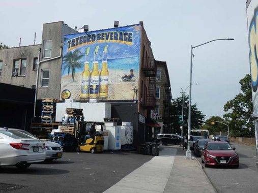
…I detoured a block on Astoria Boulevard South, which has some interesting items such as this huge painted ad at a beer wholesaler.


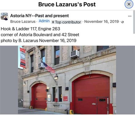
It’s impossible to obtain a complete photo of Hook and Ladder 117, Engine 263 on ABS: I would have to stand on the Grand Central Parkway guard rail across the street, where there are no sidewalks: though photographer Bruce Lazarus was able to get a better angle. The firehouse predates the GCP and was built when this was a main route called Flushing Avenue.


Amtrak trains approaching the Hell Gate Bridge are borne on a massive steel trestle constructed in the 1910s. It spans several streets on massive masonry arches. In the 1990s, the decision was made to paint them maroon, which in some spots including the bridge itself have been sun-bleached into pink.


Sound Street runs for only a block in Astoria, between 23rd Avenue and Astoria Boulevard North, one-way south, yet it does bring traffic to a bridge crossing the Grand Central Parkway. Few Astorians know that it’s a remnant of a small settlement dating back to the early to mid-1800s. East Astoria was a very small community located on Astoria’s eastern edge, about where Astoria Boulevard between Steinway Street and 43rd Street are now. It was developed earlier than the surrounding area, and when more streets were finally cut through, much of East Astoria’s small street grid actually survived. North-south streets were Planet Avenue and Sound Street, while east-west streets were Bremen Avenue, Frankfort Avenue. Please see this FNY page for additional information.
Sound Street was likely named for Long Island Sound. However, the body of water north of Long Island is called the East River bordering Long Island City. I have always made the dividing line between the East River and Long Island Sound the Throgs Neck Bridge. What say you? Comments are open.


This abandoned shed in the V formed by Sound and 43rd Streets, once a newsstand (that sold balloons?) has been abandoned for many years. Anyone remember when it was open?
23rd Road from Sound Street, once a part of the community called East Astoria. The name of the street was once Amagansett Street, named for a community in the Hamptons in Suffolk County. The Hell Gate Bridge approach trestle is seen down the block.
The back end and schoolyard for PS 84, the Steinway School. A look around the internets provides no architectural info (which is common for publicschool websites) so help me out on who the architect was. I believe the school was built in 1905.
Note that here, a standalone lamppost takes power from a connection with an overhead wire, rather than from underground conduit wiring. My question is, you find standalone poles on blocks with telephone poles and wires, while on other blocks, the streetlamps are on masts attached to the telephone poles. How and why does this occur?


I turned off 42nd Street on 20th Road, another colonial era road once known as Old Bowery Bay Road (as it once led to the East River bay) or Old Shore Road. Here, we are in the middle of Old Steinway Village. The Steinway family, master piano builders, transit magnates, and resort developers, put a personal stamp on the neighborhoods in which they resided that is visible even today. Henry Steinweg, a German piano manufacturer, immigrated to New York City from Seesen, Germany, in 1853. His sons Henry Jr. and Theodore set about making the finest pianos ever made, renowned the world over. Here, 42nd Street was once called Theodore Street.
Henry Jr.’s and Theodore’s younger brother, William, continued the family tradition (advertising their instruments as “the standard piano of the world”) and moved the operations of Steinway Pianos to Astoria, Queens. Between 1870 and 1873, William Steinway purchased 400 acres of land in northern Astoria and not only built the spacious Steinway piano factory, which still cuts an imposing figure, but a small town with a library, a church, a kindergarten, housing for factory workers, and a public trolley line. From 1877 and 1879, Steinway constructed a group of handsome row houses on Winthrop Avenue (today’s 20th Avenue) and on Albert and Theodore (41st and 42nd) Streets. Even the street names bore witness to the Steinway family, since Albert and Theodore were sons of Henry Steinway. These homes were rented by the Steinways to their workers. The area is collectively known today as Steinway Village. A detailed map exists of the old village, but it must be viewed in person by anyone who has a copy because of its incredible detail.
William Steinway’s mansion, on 41st Street, still stands on a high hill that has never been leveled, unlike the surrounding area. 41st still looks like a country lane.


Many of Steinway Village’s former buildings are still remaining in place, but with different stages of renovation.
This grouping, at 20th Road and 41st Street, looks much the same as always, though.


41st Street between 20th Avenue and 20th Road presents two different aspects of Steinway Village. Attached houses, constructed by the Steinway company in the 1870s along Theodore (41st) Street and Winthrop (20th) Avenue were once leased to regular workers at the Steinway factory and are all privately owned today. They are airy, liberally lit with sun, and have green spaces in the back. The homeowners of today, however, have resisted efforts to place the neighborhood under the aegis of the Landmarks Preservation Commission because they feared that designation would prevent them from making any alterations.
Meanwhile, fancier homes in the vicinity of 20th Road were likely built for Steinway plant managers. Some are attached, some are standalone with front and back yards.
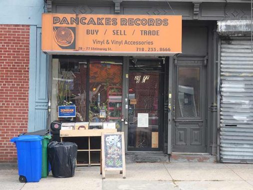
For the remainder of the walk I used Steinway Street to get to Ditmars Boulevard, then to 31st Street for the Astoria BMT N train. Vinyl that Pancakes Records sells are coming back for their purported superior sound quality and koolness factor, since turntables are relatively rare and not everyone can play vinyl records in 2025.
I will make a confession. Over the summer I unloaded my vinyl collection, appox. 300 LPs, to a collector for $300. I now listen to music exclusively in ITunes in my computer and the Music app on my IPhone. I have approximately one million MP3s, all genres, on several drives and I’m not exaggerating when I say that at age 68, I’ll never listen to all one million files. As far as music is concerned I have always prized quantity over quality and I have found vinyl to be only a slight improvement over digital. I still purchase music through a subscription with Apple Music, to which I pay a flat fee each month, so that the artists get paid. I don’t attend many live shows any more unless it’s local bands my friends are playing in. The last pro group I attended was the Smithereens and I think that was in 2017 or 2018, after Pat DiNizio had died.
I still own dozens of CDs because I burned them all onto ITunes: but if the computer goes blooey, I still have the CDs to burn onto my next machine. Apple Macs usually run well for 8-9 years and when they begin to falter, I purchase a new machine. My fear is that Apple will discontinue desktops in favor of laptops.
Steinway Junior High, or as they say these days, Intermediate School, at 21st Avenue and 38th Street. It’s another of the handsome, but anonymous school buildings from the early 20th Century.
I enjoy walking Ditmars Boulevard because it’s chockablock with local mom and pops and not chain stores, and all have individual signs that are occasionally interesting.
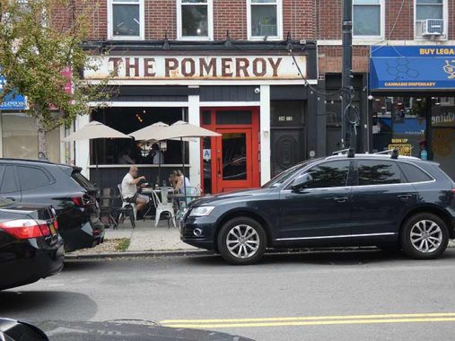
The Pomeroy, 36-12 Ditmars is so named because nearby 37th Street was called Pomeroy Street before the Great Renumbering.
I almost never give Yelp reviews, but here’s mine:
I stood outside this establishment with a camera and was nearly assaulted by the manager or bouncer or whoever he was for taking a picture (never mind all the ones both interior and exterior that can be seen here and on instagram) so, no, I won’t be patronizing this establishment.
The management later offered a free meal, but I didn’t respond. I cannot abide these people who do not allow photography. This was the closest I’ve been to a fist fight in years and it was over my using a camera. This was in early September 2021 and I still remember it like yesterday: I never forget a slight. For all I know, the clown threatening me was the owner.
This sign on the same block uses the Souvenir font, popular in the 1970s and 1980s, even sometimes as a book text, but rarely now; it’s a font of its times. It is a redesign of a font originally cut in the 1910s.


Blue and white is a color combination frequently found on sidewalk stores and restaurants, especially restaurants. Those are the colors of the Greek flag, and the Greek influence is still keenly felt in northern LIC; the iconography extends even to the use of the image of famed philosopher Aristotle in signage.
The former Pizza Palace, on the corner of Ditmars and 31st Street, was a frequent stop for me: it had plenty of seating and enormous slices. Its old space has been untenanted for a few years, so the asking rent must be enormous in this crossroads.
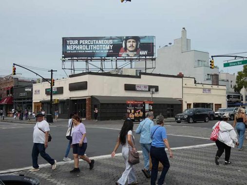
The words on the sign mean surgical removal of gallstones, kidney stones, but I don’t know what that has to do with the Navy.
Check out the ForgottenBook, take a look at the gift shop. As always, “comment…as you see fit.” I earn a small payment when you click on any ad on the site.
10/5/25
14 comments
A great tour of a changing neighborhood. My father was a super in the 60s, the fallout shelter was just outside our apartment. Water and crackers for not enough people. No training. Hah. Good thing we had school desks to hide under.
Most of Duck and Cover, the famous 1950’s film for children about atomic bomb safety, was filmed in Astoria.
I expect that, looking at the web address on that Navy billboard, they are recruiting doctors and surgeons to join the Navy and perform such operations for conditions that would otherwise disqualify certain seamen from certain MOS’s (military occupational specialties). It would be a retention thing, i.e., you don’t want to go to the trouble of training up these seamen for these positions only to lose them to preventable/curable medical conditions, so you want to have enough medical personnel and bed space to address those conditions.
The official line between East River and Long Island Sound is the east-west line between Sands Point and Pelham Bay Park. Throggs Neck Bridge typically used as a landmark to approximate the line.
If you like Sunnyside Gardens, you’d love Hastings House — a similar (but far nicer) 1930s housing complex that overlooks the Hudson River in Hastings-on-Hudson. http://www.hastingshousecoop.com/photo-gallery
I’m guessing the font used on the Jackson Diner is high
Clyde-Beatty Circus
What a revelation! I recall spending many evenings, after school at the HS of Art & Design in Manhattan, with a group of friends at a home on Bliss Street. We would hang out and discuss all matters of art, design, and social issues, all of them sans alcohol, cannabis, or drugs into the early evening when we would all depart to our homes everywhere in greater NYC. I was the only one who lived in Manhattan.
Culver, John
Attachments
1:07 PM (1 hour ago)
to me
I live on 23 Road (house with the white truck in front). The city web site refers to the street as Frankfort Avenue. Look here for an old map Kevin posted a while ago. https://forgotten-ny.com/2021/01/sound-street-astoria/east-astoria/ Attached is what my house looked like in the 1940s.
Kevn, I;m no expert on computers, far from it, but I have a ton of music on my laptop. With help I backed it up with an external hard drive.
Kevin: Percutaneous nephrolithotomy (PCNL) is a minimally invasive surgical procedure used to remove KIDNEY STONES that are too large to pass through the urinary tract.
As it says in the piece.
Kev: Gallstones form in the gall bladder. Kidney stones form in the kidney…
OK, fixed
This is some information concerning that street light in the photo with an overhead power supply. Whenever a street light is called in as not functioning, and the contractor reports a Con Edison power supply failure, it results in the City reconstructing the pole’s foundation. I don’t know if this policy is a Con Ed requirement, or the City is doing this over heightened electrical safety concerns. The power failure could be caused by a corroded conduit in the foundation or in Con Edison’s conduit from the manhole to the street light. When the City rebuilds the foundation, Con Edison’s contractor then runs a new conduit between their manhole and the new conduit in the foundation. For a number of years now, if there is an overhead secondary available, the street light will be connected to that supply rather than replacing the old underground conduit. When you consider the work and expense involved in replacing the underground conduit, it is understandable.
First the line of the trench must be saw cut to insure a neat excavation. Then the asphalt and concrete under the asphalt is removed, along with the dirt down to about a four foot deep trench. Then the new conduit is run. Then the dirt is replaced in the trench, along with new concrete and asphalt. Then a Con Ed crew comes and places new wire in the conduit. How much? Ten thousand? More? Even when you consider that Con Ed is billing a connection and demand charge in addition to kilowatt-hour delivery charge, with many of the led street lights now drawing less than 100 watts, it probably takes twenty years to recover the trenching cost.