
By SERGEY KADINSKY
Forgotten NY correspondent
In the midst of the coronavirus crisis, nearly all aspects of the city’s public life have shut down to keep people away from each other. In the center of my borough’s eastern half is a sizable green space that offers ample distance from other people, and remnants of transportation history if one knows where to look.
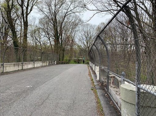
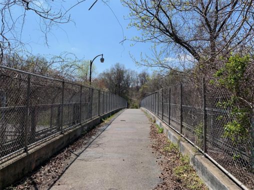
I noticed one example of altered history when biking on the Queens segment of the Long Island Motor Parkway. Upon entering Cunningham Park, the historic route is blocked by the embankment carrying the Clearview Expressway, forcing the bike path to make a hard right and then into a long, dark tunnel under this highway.
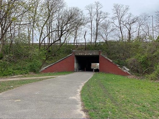
Unlike the tunnels of comparable large parks such as Central Park or Prospect Park, the bike route tunnel under the Clearview Expressway is as charming as a dried-up storm sewer minus the smell. The western portal to this underpass opens into an expanse of sports fields where I’ve safely flown kites and picnicked with my children. Next to the fields is a forest where the original route of the Long Island Motor Parkway is hidden beneath the foliage.
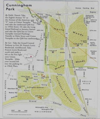
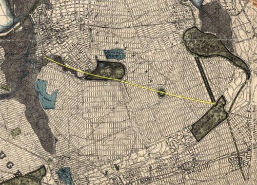
On the official map of Cunningham Park from 2009, I marked the park’s forgotten roads: in yellow the abandoned section of Motor Parkway; in brown the full route of Hollis Court Boulevard; and in orange the Stewart Railroad.
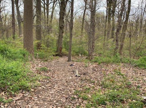
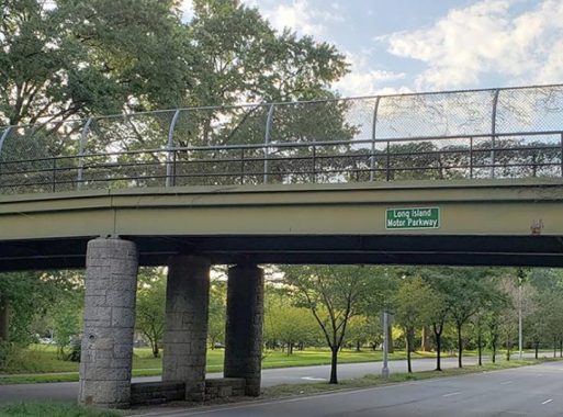
Deep in the western section of the park’s Middle Woods one can find the concrete posts of the Long Island Motor Parkway. They were installed here in 1926, marking the world’s first highway, a 45-mile route running from Fresh Meadows to Lake Ronkonkoma, a toll road used by wealthy individuals. It was extended west to Hillside Avenue in 1926, using a series of overpasses over selected roads.
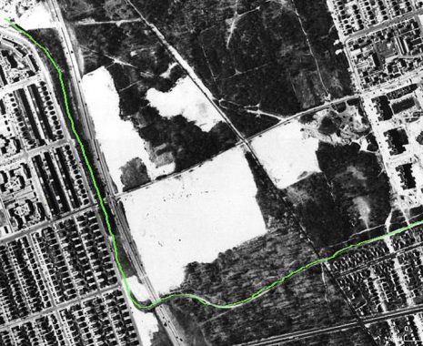
The forested parcels of this park were acquired by the city as Hillside Park in 1928 in anticipation of the area’s urbanization. The forest was surrounded by farms but the city’s maps already had the prescribed street grid subdividinig the potato fields and golf courses. In 1935 the park was renamed for City Comptroller W. Arthur Cunningham, who died the previous year. In this 1951 city aerial survey, I highlighted the route of Motor Parkway when it was still running straight through the Middle Woods. The construction of Clearview Expressway in the following decade cut straight through the forest, interrupting the route of Motor Parkway and Hollis Court Boulevard.
This explains why there is a segment of this road north of the park and another to its south. A piece of Hollis Court Boulevard south of 73rd Avenue running through the park’s Middle Woods was renamed Hollis Hills Terrace. Driving on this road one can’t believe that this is inside the borders of the city. The road is very ancient, once known as Queens Road as it connected the old settlements of Flushing and Queens Village.
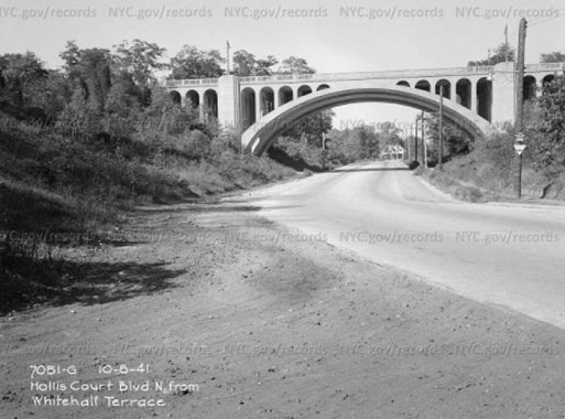
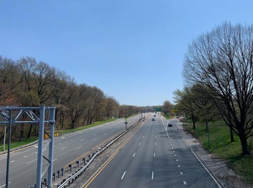
On the southern edge of Cunningham Park where the glacial terminal moraine descended down to the coastal plain, Hollis Court Boulevard passed under a graceful arch built in the 1930s to carry Grand Central Parkway atop this ridge. The arch’s design is nearly identical to Henry Hudson Parkway across Dyckman Street. That was the prewar Robert Moses. A generation later, he settled for functionality. Hollis Court Boulevard was broken up and Clearview Expressway was extended through this pass in the ridge. A stack interchange took the place of the Art Deco-style overpass.
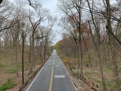
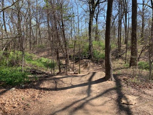
Following the completion of Clearview Expressway and the bikeway’s underpass tunnel, Long Island Motor Parkway was rerouted through the forest, winding around the trees in stark contrast to the nearly straight direction that William K. Vanderbilt envisioned.
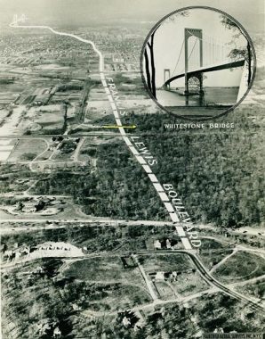
In tandem with the construction of Whitestone Bridge, the city extended Francis Lewis Boulevard across the length of the borough. In this promotional aerial photo from 1940 looking north, the oval road in the foreground is Epsom Course, a former racecourse in Holliswood that is today a residential street. Continuing north on the newly-built boulevard we see Grand Central Parkway, the toll-free Robert Moses creation that killed the privately-run Motor Parkway. The next road is Union Turnpike, at the time designated as State Route 25C and near it marked in yellow is Motor Parkway.
When Long Island Motor Parkway was built, Francis Lewis Boulevard did not yet exist, so the bridge carrying the parkway over the boulevard was built in 1940, after its conversion from a private highway to a public bikeway. Unlike the LIMP’s other bridges, which are concrete, this one is mostly metal in its design. The section of Francis Lewis Boulevard running through the park resembles a highway and for decades was used for illegal racing at night. In recent years speed cameras and a traffic light in the middle of this long stretch have reduced this dangerous pastime here.
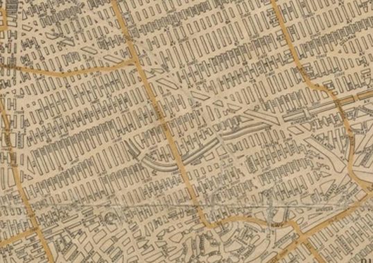
The lineage of Francis Lewis Boulevard predates Cunningham Park and Whitestone Bridge. It was first proposed by the borough’s topographical bureau in 1912. In this 1922 Hagstrom map of Queens, we see an endless grid of paper streets blanketing the borough. Highlighted on a north-south route is Cross-Island Boulevard, proposed early on to run from Whitestone to Rosedale, uniting the future neighborhoods along the way. It was renamed in 1940 for local revolutionary Francis Lewis to avoid confusion with Cross Island Parkway. Motor Parkway defies the grid here with the mapmaker erroneously giving it underpasses instead of overpasses. A century later, west of the park the grid appears as planned. To its east is a set of garden apartment superblocks built in the 1950s. The other grid-defier here is the route of the Stewart Railroad followed by Peck and Underhill avenues. Stewart Avenue in Hollis Hills also follows this route.
[In 1922, most of the streets shown were “paper streets” existing in the imaginations of city planners and developers. –ed.]
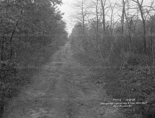
From 1873 through 1879, dry goods magnate Alexander T. Stewart’s Central Railroad of Long Island (CRRLI) ran on a nearly straight line between Flushing and Floral Park. With a more heavily used line running through Jamaica and Stewart’s line running through sparsely populated farmland, the latter was abandoned. A 1928 photo by a surveyor from the Queens Borough President’s office shows the intact route within Cunningham Park, which was acquired that year by the city. On this note, Kevin Walsh documented a set of surveyor’s photos of the park from 1940 showing how this park appeared at that time.
In 1900, Louis Risse, the chief engineer of New York City’s Topographical Bureau and the designer of the Grand Concourse, proposed a linear park on the Stewart Line that later became the western Kissena Corridor. The western corridor and the right-of-way inside Cunningham Park were proposed for a grid-defying boulevard, which I highlighted. In the 1930s, Robert Moses designated Risse’s route as Kissena Corridor Park, connecting Flushing Meadows to Kissena Park to Cunningham Park. Today, there are no traces of the right-of-way. It is entirely overgrown with trees. A half century later, this corridor and the Motor Parkway bikeway were incorporated into the Brooklyn-Queens Greenway, a 40-mile series of bike routes running through parks from Coney Island to Fort Totten that is the city’s equivalent to the Appalachian Trail.
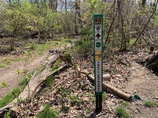
Having discussed the lost railroad, boulevards, expressway, and bikeway, there is one more transportation-related item that is unique to Cunningham Park. It is one of three parks in the city that has mountain bike trails. As it is with ski slopes, such trails have designations for experts, intermediates, and beginners.
One footbridge connects the two halves of the North Woods that are bisected by Clearview Expressway. The footbridge has the Gothic-style walkway lamps that were first documented by Kevin in 1999.
Clearview Expressway is among the later Robert Moses projects, lacking the decorative features of his prewar highways. It was rammed through Bayside despite fierce community opposition. Running a highway through the forest was easy, but then at Hillside Avenue the highway abruptly ended its run as a result of opposition from Hollis residents, who succeeded in saving their homes. The highway has its curiosities, as seen in Kevin’s page on its footbridge lamps and its now-gone railroad underpass.
Deep in the woods there are earthen ramps for mountain bikers to do stunts. The trailhead for this network of routes is at 210th Street and 67th Avenue. Despite its 358 acres, Cunningham Park is one of the least publicized of the vast parks of Queens. No stadiums, no pools, or rec centers here. It’s mostly fields and forests. Perfect for social distancing.
Sergey Kadinsky is the author of Hidden Waters of New York City: A History and Guide to 101 Forgotten Lakes, Ponds, Creeks, and Streams in the Five Boroughs (2016, Countryman Press) and the webmaster of Hidden Waters Blog.
4/20/20
17 comments
thank you, this site is an amazing resource on a place I love.
In the photo of the steel bridge carrying the Long Island Motor Parkway, you can see the round hole in the stone column that
was a flush mounted warning light. There would have been an amber glass lens on this fixture.
Great..rode my bike from Electchester to the Creedmoor Embankment many
times
If I remember correctly, on 73rd Avenue just east of the Clearview Expressway are athletic fields (several soft ball diamonds & a cricket pitch). Also, at the intersection of Union Turnpike & Francis Lewis Blvd. there are tennis courts. The Queens park system is a great recreation resource. However, once the COVD 19 restrictions become history residents will have to deal with consequences of the state’s new no bail law (a walk in the park won’t such a walk in the park anymore. Such a pity.
Hi Sergey-
I’m one of the inspectors for the Parks Dep’t, and have spent almost 20 years walking the trails Cunningham Park. Something that’s always puzzled me are the old concrete paths in the North Woods section, on the west side of the Clearview Expressway and south of the Horace Hording (“Zone 4” in Parks-speak). I don’t recall seeing concrete in almost any other park trail system, and was wondering what the history behind this was. An old roadway (not the Motor Parkway)? A simple aberration? Thanks!
At one time there was an anti aircraft battery at Francis Lewis and Horace Harding. The concrete is probably from some of the structures what not that were there.
Interesting- I never would’ve thought of that, considering how in-land Cunningham Park is, but after a little research, I guess you’re right:
https://www.northamericanforts.com/East/nycity3.html
This lists one at 73rd Ave & FL Blvd, which is close enough.
I lived on 193rd Street , between 73rd and 75th avenues, 1 1/2 blocks from Union Turnpike. I believe there were ball fields in Cunningham Park, as well as tennis courts. You had to walk a bit to get to the tennis courts. I recall there was a field house and a flagpole and a stone with W. Arthur Cunningham’s name and birth and death dates.
The memorial flagpole for Mr. Cunningham is located on the south side of that giant lawn on 193rd Street and the tennis courts are nearby. The field house next to the tennis and boccie courts is presently used as the park’s administrative office. The park also has a mounted police unit stable deep inside its forest, and a Parks operations garage on 199th St. and Union Turnpike.
Why did the Clearview Expressway end at Hollis Court Blvd. because of opposition from Hollis homeowners when that area is Queens Village, not Hollis, and why is Hollis Court Blvd. so named when it too is in Queens Village?
Hollis Court Boulevard runs through Queens Village, not Hollis. And Flushing Avenue is far from Flushing. Here’s another trivia item: the portion of Hollis Court Boulevard in Queens Village is part of NYS Route 24, but unsigned.
I used to take people for Road Tests to Cunningham Park. Great spot very peaceful.
Thank you for this very interesting historical look at Cunningham Park and The Motor Parkway. I grew up in the 50s and 60s off Epsom Course on Keno Avenue so this brings
back many memories of cutting through the woods on my way to the ball fields to play Little League Baseball with the Hilltop Little League.
The Queens section was a LIMP extension built in the 1920’S to increase business for the road now already doomed by the Northern State.Please refer to the definitive book on the LIMP by H. Kroplick published by Arcardia Press.
You notations of 1908 are incorrect for that Section.
I still love your website and I am a huge NYC /LI history buff.
Love to hear from you
I grew up nearby and played baseball on the fields near 73rd Avenue with my little league about 1960-1961. It was a fun time to ride your bike there and you didn’t have to be home until dinner time
In the mid 60’s I used to ride my stingray on FLB over the LIE to get to the park, across from Blue Bay Diner! mmmm french fries and gravy.
Until I saw pictures of this park here on this website both past and present, I almost didn’t know that this one even existed and it feels pretty underrated and unnoticed in terms of NYC parks especially for one that is pretty big in size.