

In what I first imagined would be my only post on the subject, I wrote about a few streets around town named for other streets, Broadway in most cases. Since then, a few more were pointed out to me and I’ve found a few more. It could be another ongoing series…


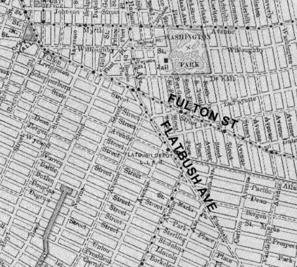
I’m showing a map of downtown Brooklyn from about 1890, to which I’ve highlighted Fulton Street and Flatbush Avenue. As you can see, Flatbush Avenue began at Fulton at about Nevins and then proceeded southeast to Marine Park as it does today. It’s hard to imagine downtown Brooklyn without a Flatbush Avenue Extension that gets traffic to the Manhattan Bridge, but the Extension was created when the bridge was built at the dawn of the auto age.
House numbering for the Flatbush Avenue Extension begins at about Concord Street and runs to Fulton, where numbering for Flatbush Avenue proper begins there at #1. Because #1 is at Fulton, it would have been difficult to begin it at Concord and re-number the entire avenue, so the section between Fulton Street and the Manhattan Bridge retains the “Extension.”
In Bedford-Stuyvesant, Eastern Parkway originally ended at Ralph Avenue, but it was later extended northeast to Bushwick Avenue. On some maps, it’s still called the Eastern Parkway Extension, but since it just continued the address numbering of the already established Eastern Parkway, it isn’t called an Extension, and street signs just call it Eastern Parkway.

I have written about West 9th Street before, in my Streets That Shouldn’t Have Their Names series, but it also applies here, since it’s a street that’s named for another street.
Brooklyn has a few duplicate streets, such as Atlantic Avenue (Cobble Hill, Fort Greene, etc., and Sea Gate) and West Street (Gravesend, Greenpoint). It also has two West 9th Streets. One of them can be found in Gravesend, and runs in one piece from Bay Parkway south to 86th Street and Avenue V. (I always thought it strange that 86th Street pushes so far southeast into Gravesend, but this 1873 map shows that it was always mapped to do so.)
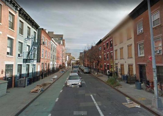
The other West 9th Street is on the outskirts of Red Hook at the south end of Carroll Gardens and is a literal western extension of 9th Street, running from Smith Street west to Columbia Street. Maps made before about 1900 show it as Church Street.
The first 9th Street bridge crossing the Gowanus Canal was completed in 1905; in 1999, the bridge reopened after a complete renovation. In the 1930s, a massive railroad trestle carrying the IND subway was built over it. My educated guess why Church Street became West 9th is that the city wished to continue 9th Street further west after the bridge opened in 1905, but didn’t want to renumber all the houses on the street all the way to Prospect Park, which they’d have to do. So, West 9th Street it was.

Like LaGuardia Airport, Kennedy Airport has its own street system and its own street sign design. I don’t drive, and JFK is so vast that it precludes my exploring it on foot. But there are a couple of street and road mysteries.
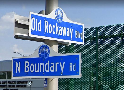
On older maps, Old Rockaway Boulevard is shown branching from Rockaway Boulevard proper at Farmers Boulevard, and then dead ending in cargo areas. Today, the configuration has changed, with Old Rockaway Boulevard running south past an NYPD tow pound from Boundary Road, just inside the airport east of Farmers Boulevard. Originally, whoever named it may have thought it was an unstraightened bend of Rockaway Boulevard proper, but I don’t buy it.

If you look at a map of Brooklyn from 1766, Fulton Street (or the road that evolved into it) is already in place, twisting and turning before running generally southeast and east. It was actually called Kings Highway until the US Revolution. Roads laid out like this generally do so to avoid hills or swamps. But Fulton Street was never straightened and the portion between the East River and Borough Hall was called Fulton Street for over a century, until the large park called Cadman Plaza was created in the 1950s, and the portion of Fulton bordering the park was renamed Cadman Plaza West.
The street carried the name Cadman Plaza West all the way to the East River, which didn’t make much logical sense, since there’s no Cadman Plaza north of Prospect Street. In the 1970s or 80s (I’ve never been able to pinpoint the year; help me in Comments) the Department of Transportation decided to right this error by renaming the portion between the river and Prospect Street “Old Fulton Street.”
However: Prospect Park West between 15th Street and Green-Wood Cemetery is still called that, even though it doesn’t border Prospect Park at all there.

Besides the still-existing Kingsbridge Road, there is a tiny dirt path, Old Kingsbridge Road, running one block between Grote Street and the intersection of Garden Street and Southern Boulevard. It is identified by a single street sign and is paved only partway: the section with a couple of houses facing it, which is likely why this section has been preserved. Undoubtedly, new development will likely eliminate it some day.
At present, the Bronx’ Kingsbridge Road runs from Marble Hill at the Bronx-Manhattan line (it’s called West 225th Street in Marble Hill) east and southeast to Fordham Road, following a meandering path defined at first by an animal trace, then a beaten path used by Native Americans through the woods, then a colonial-era road used by both British and American troops in the Revolutionary war. However, it used to be much longer. The current routes of Third Avenue, East 184th Street, East 182nd Street and Grote Street in Belmont all trace its ancient pathway. This remnant is by far the most obscure.

Amboy Road is one of the major routes in southwest Staten Island, running from Richmond Road in New Dorp all the way to Tottenville. It’s named for Perth Amboy, NJ, a town opposite Tottenville on the other side of the Arthur Kill. It curves, twists and turns to avoid hilly or swampy ground.
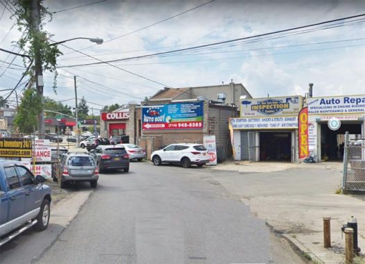
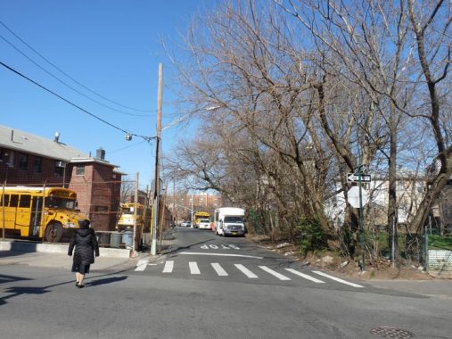
At Armstrong Avenue, there’s a particularly snaky bend, Old Amboy Road, that makes an S-curve, crossing Amoy Road twice and eventually straightening out a bit and ending at Amboy Road near Richmond Avenue. The western end of Old Amboy Road was renamed St. Albans Place in the 1970s (see below). Much of Old Amboy Road is lined with auto repair and tire joins, like those shown here.
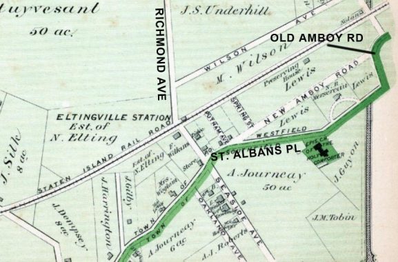
In this 1873 map, the current Amboy Road was a new section built to straighten it out. The original path of Amboy Road can be seen along the thick green line.
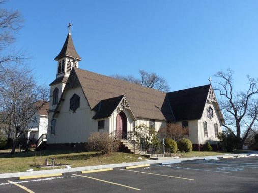
Sometime in the 1970s, the western end of Old Amboy Road was renamed St. Albans Place for the historic Episcopal church between Pacific and Winchester Avenues. Originally Church of the Holy Comforter (which sounds like a blanket) a small wood church was built in 1865 and moved to this location in 1873 and gradually expanded. the church was designed by architect Richard Mitchell Upjohn, brother of the great church architect Richard Upjohn.

Stretching the concept just a bit, as its counterpart is New Utrecht Avenue, Old New Utrecht Road runs in two pieces, one between 36th and 37th Streets at 14th Avenue and another between 48th and 53rd Streets, between 17th and 18th Avenues. It’s a remnant of a road that existed in colonial days, before the street grid was built, called Old Road From New Utrecht To Flatbush.
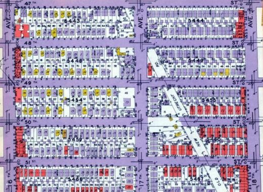
In 1929, when this map was published, the road was unpaved as a lack of purple coloration indicates. That state continued into the 1970s when it finally got a coat of blacktop. The road is still occasionally without a sidewalk.
Check out the ForgottenBook, take a look at the gift shop, and as always, “comment…as you see fit.”
3/15/21
12 comments
How about North Henry Street in Greenpoint which was named as opposed to Henry St which runs from Brooklyn Heights to Ted Hook
And North Moore
S. I. Old Richmond Terrace has been renamed Snug Harbor Rd.
When was it called Old Richmond Terrace?
No, it was just Richmond Terrace until the road was straightened out sometime in the 1920s or ‘30s. The old section was renamed Snug Harbor Road.
How about Manhattan, I could think of Old Broadway in West Harlem, there must be more
See Part 2
Does having old in front of it usually mean that it was a remnant or vestige of the original road before its present day route or that could mean other things depending on what it is?
Usually it’s a remnant of a longer road.
Staten Island has a trifecta of major streets named “Richmond” for obvious reasons – Road, Avenue, and Terrace. There was at one time a Richmond Parkway, which was re-named Korean War Veterans Parkway. There is also a Port Richmond Avenue. Must be confusing to persons who don’t live there.
Staten Island has a Richmond Hill Road, which intersects a Forest Hill Road, but certainly not in Queens.
Not the theme…I’m doing streets that are named for other streets, as “Shore Road Drive” is named for “Shore Road” and “North Henry” is so named because there was already a Henry.
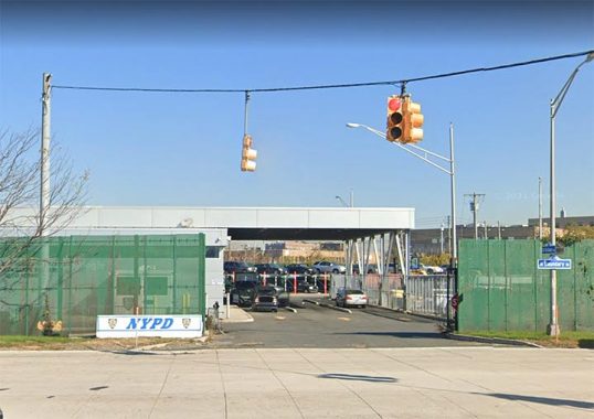
Old Rockaway Blvd. is a remnant of the original Rockaway Blvd. that had its right of way moved when the airport was built in the late 1940’s. As you stated, Old Rockaway Blvd. was later expanded to include areas within the airport that were
never part of the oiginal road.