

Today Sergey yet again has found something I was completely unaware of… –ed.
By SERGEY KADINSKY
Forgotten New York correspondent
ACROSS the city there are numerous barriers to pedestrian connectivity that require the public to take a longer route between points A and B. On the Bronx River Parkway, the .7-mile drive between Noble Playground and the borough Parks office at the Ranaqua building is only a minute without traffic. The highway runs across the railyard on a viaduct, while bike and pedestrian routes must go around it. If one were to walk between these two points, the map apps suggest that it would take 30 minutes on a roundabout 1.5-mile route.
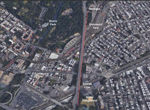
But on my drive to the office I noted a sidewalk on the northbound shoulder of the highway that could serve as a link between Noble Playground and Bronx Park, reducing the walking distance to ten minutes. I walked the route in search of other items worthy of Forgotten-NY. Relying on Google Earth, I marked this sidewalk as an orange line that provides a direct route for a ten-minute walk rather than 30 minutes as suggested on the apps.

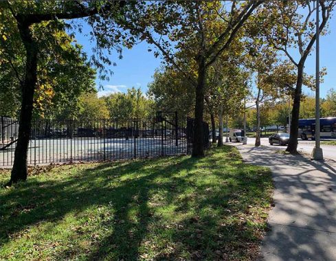
Looking south from Bronx Park we see a fork in the road. The Bronx River Greenway goes left, descending under the highway to East 180th Street station and the West Farms neighborhood. It then continues south to Starlight Park. On the right, the path appears poorly maintained but visible enough to show that it was built for the public.
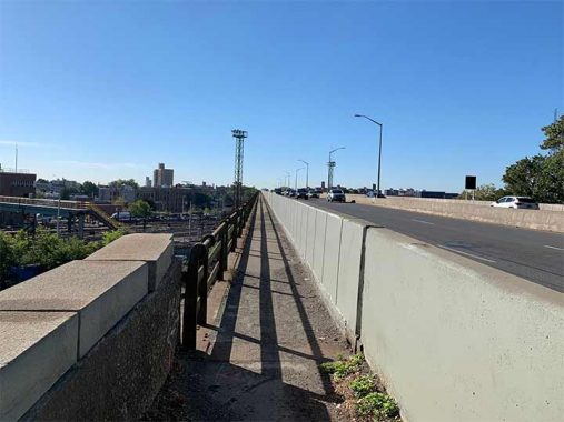
The path becomes a protected sidewalk that crosses the train yard at an elevation of six stories above the ground. It isn’t the High Line and the view to the northeast offers few high-rises in a corner of the borough that is less dense and more suburban as it approaches the city line. This viaduct opened in 1951, when the Bronx River Parkway was extended south of Burke Avenue to terminate near Soundview Park. There were plans to extend it further south, as mentioned in my Clason Point essay.
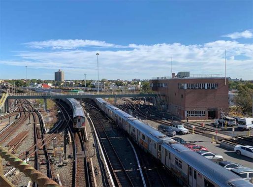
The Unionport Yard is where the 2 and 5 trains diverge on their way north. The former rises as an elevated line above White Plains Road, terminating at Wakefield; while the latter travels on a repurposed railroad line to Dyre Avenue in Eastchester.
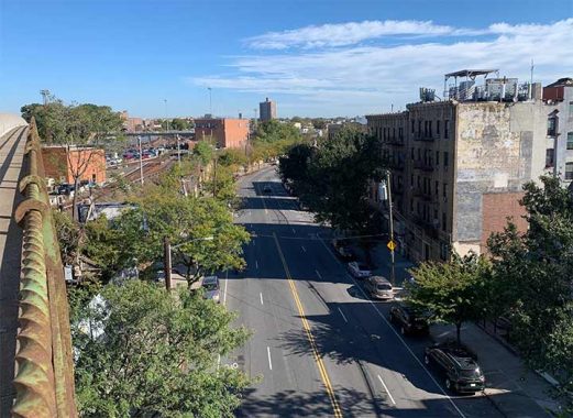
Morris Park Avenue begins near this viaduct, a two-mile run between West Farms at the Albert Einstein College of Medicine. Between these points is the historically Italian Morris Park neighborhood. Aiming for the eyes of motorists, there is a fading mural ad for Rep. Paul Fino, who represented this section of the Bronx between 1953 and 1968. Our contributing writer Gary Fonville first identified this ad in 2012. A decade later it is still very legible. Also visible here is John Calandra’s name, who was a State Senator from 1966 to 1986. A champion of Italian-American culture, his name appears in CUNY’s John D. Calandra Italian American Institute, Public School 14 co-named the John D. Calandra School, and Bronx Terrace in Yonkers which was co-named for him in 1986 but those signs are gone.

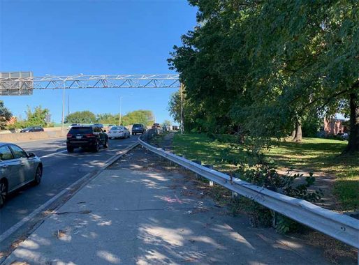
Another railroad that runs under the viaduct is the Amtrak Northeast Corridor that will soon include Metro North service to Penn Station. Two tracks to the left are used by Amtrak and the third track is used by freight trains to access the yards in the Bronx, Queens, and Brooklyn. The right-of-way here has the width to accommodate additional tracks.

The viaduct ends on the other side of the tracks, where the newest visual item is the exit sign for Sheridan Boulevard. Designed as Interstate 895, it was supposed to connect the Bruckner Expressway with the Cross Bronx Expressway, Bronx River Parkway, and then run northeast to link with the New England Thruway. Community opposition resulted in only 1.2 miles of it being completed. In 2017, it was downgraded into a state route and converted into a boulevard. Its namesake is Arthur V. Sheridan, an engineer who served as the Bronx Borough Commissioner of Public Works from 1952 until his death in a car crash a decade later. The proud public servant was buried at Woodlawn Cemetery, in the borough where he worked.
Noble Playground is found at the southern end of this secret walkway. This park was completed in 1939 in tandem with the parkway, rather than the expressway that was built two decades later. According to Bronx street historian John McNamara, this park and the adjoining Noble Avenue were likely named after Alfred Noble, a city engineer in the 1880s.
Returning north to Ranaqua, it is easy to miss this hidden walkway as the sidewalk ends and a metal barrier blocks further passage.

The walkway on the viaduct is on the east side of the road, while Manhattan and the former administration building of the New York, Westchester & Boston Railway that is today’s East 180th Street station, are on the opposite side. The building is a designated city landmark.
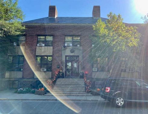
Forgive the glare of the sun as I passed by the Ranaqua building in the morning. Its story began in the 1930s when it was one of many public works projects across the city. Each of the boroughs has a Borough Parks Commissioner based inside an iconic building. The Queens commissioner has a desk in the Overlook in Forest Park; Brooklyn is based at Litchfield Villa in Prospect Park, and Staten Island has Stonehenge at Clove Lakes Park. The Manhattan commissioner has the least parklike office- Arsenal West, a nondescript tower a block west of Central Park. The citywide Parks Commissioner’s desk is at the Arsenal in Central Park on Fifth Avenue.

Its design is simple, no elaborate mosaics or sculptures here. A recent feature here is the green rooftop, a miniature grassland on top of the garage. The largest green roof in the city’s parks is on Randall’s Island at its Five Borough Shop where vehicles are repaired.
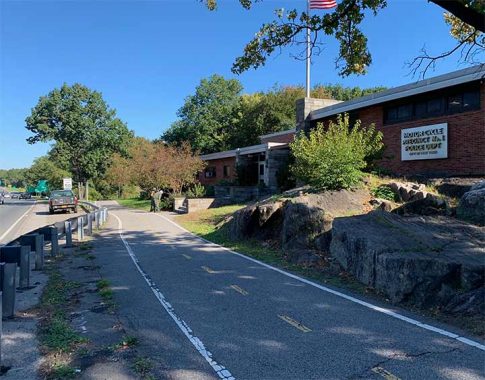
Another building in this section of the park next to Ranaqua is the police station that serves the highway patrol. Looking north, the Bronx River Greenway continues its way through the park to the city line and beyond. Bronx River Parkway also goes in the same direction into the heart of Westchester County.
Sergey Kadinsky is the author of Hidden Waters of New York City: A History and Guide to 101 Forgotten Lakes, Ponds, Creeks, and Streams in the Five Boroughs (2016, Countryman Press) and the webmaster of Hidden Waters Blog.
As always, “comment…as you see fit.” I earn a small payment when you click on any ad on the site.
10/21/21
15 comments
Wow, I need to walk this. I’ve seen it but assumed it was for maintenance only. There is a similarly constructed walkway on eastbound L.I.E. crossing over College Point Boulevard between FMCP and Mt. Hebron Cemetery. Haven’t ventured on it but have seen an occasional walker. The eastern side requires the walker to descend down the L.I.E. embankment then cross the service road to the sidewalk. Might try this in the early daylight hours on a Sunday.
If you’re talking about the eastbound service road crossing Flushing Creek, yes it has a sidewalk that’s unprotected from the traffic. It approximates the route of Strong’s Causeway, the predecessor to the LIE.
No. That’s a different path. That’s where the Q88 and Q58 stop. The walkway I mentioned is on the main road and protected by jersey barriers on one side and the green painted metal barrier on the other. Very narrow.
Street view for main road L.I.E. shows the protected walkway transitions to an unprotected shoulder on the east side. The choices are climb over the green rail or walk on the shoulder and step over a smaller guide rail. Not a great experience either way. Will still try it soon
Much of that path already existed just overgrown and needing a repaving. The route adjacent to the subway tracks is new to my knowledge, I’m out of the area 20 years. I used to ride over the bridge and then haves to sneak off past the parks department building pictured.
These days, such a walkway would have a much taller fence at the edge curved inward at the top making it harder for evildoers to throw stuff over the edge to the terrain below. I would be too nervous to walk that path unless the fence were taller than I.
Where the splits is heading south before th start of th overpass is an existing trail I I used to ride on , to the left is the newly made path that dips to track level with unionport train yards eventually crossing underneath parkway and exiting onto 180 st. where fire department has a large antenna, the park used to be called fireman’s field, I played little league baseball there in the late 60s. Transit yards are were above on a stone wall, I think the zoo uses this area a a repair area for the wild Asia ride. Action kid a YouTube contributor I think did a short video of a ride he took a few years ago, I can’t find this clip, though. None of this existed when I last rode the Bronx streets, I exited the park on noble ave and continued my ride using local streets.
I have driven down this part of the Bronx River Parkway numerous times, and I never knew that there was a walking trail right beside it.
One of the stranger pedestrian walkways I know of is in my Connecticut hometown of Waterbury. It starts out on Wilson Street as a fairly long pedestrian bridge over Connecticut Route 8, which is a limited access highway. that then turns 90 degrees and becomes a sloping walkway several hundred feet long that leads down to Riverside Street close to the Naugatuck River. Given the area’s topography the Wilson Street end is at least 100 to 150 feet higher in elevation than the Riverside Street end. As far as I know it dates back to the construction of Route 8 in the late 1950’s.
If this walkway serves any meaningful purpose it’s news to me. Essentially, it connects nowhere to nowhere. Wilson Street at the passageway’s western end is a quiet street with very little pedestrian or vehicle traffic while the Riverside Street end is a dreary spot under highway ramps. There is no signage marking either end and the Wilson Street entrance is so obscure I doubt any passerby would even notice it’s there, not that there would be any passerby in the first place:
https://goo.gl/maps/TFrSQWQ9XGQszDqp8
Note: I’ve only been over it once, when me and a couple other kids walked over it on a dare when we were 12 or 13. It seemed utterly endless. The dare part was because of a schoolyard rumor that criminals hung out on it.
Further note: maybe my Google skills are deficient, but there’s nothing i can find online about the passageway. I don’t even know if the city or state is in charge of it.
Thanks for the tip Pete! Was there just today (10/28/21). Also explored around Waterbury. The bridge does seem quite useless and not a little skeevy, but it was fun to find and walk over Rt 8.
I’m guessing this walkway was built to provide access to the train station. The walkway leads to Freight Street, which used to have stairs up to the old platforms back when dozens of trains a day stopped in Waterbury. It’s also the southernmost pedestrian crossing of Route 8 for quite a distance. There must’ve been some influential state rep or senator who wanted to keep pedestrian access to the station (and City Hall and the government buildings just beyond it) for the west end of town.
I walked this path many times as a kid in the 70s and even recently as well. I have some old school pictures I really need to post.
Years ago, we were using Google Maps for directions. Short story: The route took us into a wall not being programmed to know that one direction of the cross street was raised a couple of dozen feet. An earlier time, Google (not the Maps app) gave directions that required an illegal U turn on a busy street. A look at a, you know, map for the return trip showed a much better route.
So Sergey’s discovery here: Not so surprising, a little disappointing. I know, the media narrative is Google Maps’ untouchable superiority; too bad facts and stuff suggest maybe not so much.
Thanks for posting. I recently started using this stretch of the Bronx River Pkwy for part of my commute, and right away I was wondering about that walking path on the elevated section.
Just came back from this part of the Bronx and walked this path. Thanks Sergey!