

In April 2017, Mitch Waxman, a member of the Newtown Creek Alliance, conducted one of his Newtown Creek tours, his most comprehensive, which he called “Creek-a-Thon”. It was an all-day affair comprising approximately 8 hours with over ten miles of walking. I accompanied the group on the first leg of the tour, but finding myself hopelessly behind the rest, I decided to call it a day when we got to the now-deceased Goodfellas (originally Clinton) Diner on Maspeth Avenue. (Sometimes I feel I am the only native New Yorker who walks slowly.) A few weeks later, in a walk that included me and filmmaker Heather Quinlan, we mostly covered the remainder of the tour.
I have over 100 photos from that second leg and while I will skip a few it will take more than one post to get through them all, since I have stopped doing 100-photo post extravaganzas. Since I brought up the rear as usual, you will see three people in some photos, mostly from the back: Mitch, Heather and Mitch’s friend Don, who has accompanied Mitch and I to other forays such as the Rockaways.
Life changes. Things change. In 2022 Mitch and Mrs. Mitch moved to Pittsburgh and before that, Heather and her husband Adam had moved to picturesque Mt. Tabor, NJ. I am the constant and will likely always remain in affordable Little Neck.
Newtown Creek, a naturally-formed inlet of the East River, was one of the northeast’s first superhighways, in use by Native Americans for untold centuries before the white man arrived in the early 17th Century. Dredging and industrialization ensued, solidifying the Creek in concrete and formalizing its length and those of its tributaries, Dutch and English Kills, Whale Creek and others. Railroads and highways accompanied its length as well. Manufacturing and industry arrived, with rendering of domesticated animals, paint and varnish manufacturing, disposal of scrap metal, and other activities of the Age of Industry. The Creek itself, as well as deep underground in surrounding territories such as Greenpoint, Dutch Kills and Maspeth, were hopelessly contaminated in what many fear to be a permanent condition. Plans are now underway to alleviate the pollution, but will the area ever be made clean again? It may take hundreds of years even if efforts are intensive. Nature is hardy, however, and some fish, crabs, turtles and water birds can be found here. Tall tales abound that large snapping turtles that can hold their breath underwater for lengthy periods are in the Creek’s depths. Newtown Creek has gotten rather cleaner over the past decade but it remains quite toxic.
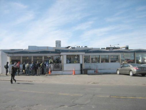


I’ll begin where I left off, at the Clinton, a.k.a. Goodfellas, Diner. The Clinton, at 58th Street and Maspeth Avenue, was one of a vanishing breed of roadside diners, catering to workers in an industrial area and motorists who are passing through. It stands next to freight tracks of the Long Island Rail Road. DeWitt Clinton’s mansion, for which the diner had been named, stood nearby until 1933. A house belonging to family members of mid-19th Century Maspeth “mover and shaker” James Maurice is across the street. Community meetings took place here, and it had been used on numerous occasions for movie and TV shoots when a scene needs authenticity. One of those was the film Goodfellas where a scene with Robert DeNiro and the late Ray Liotta was filmed; diner owners the Diamantis family renamed the Clinton Diner Goodfellas Diner in its honor. Other TV shows such as the Good Wife, Six Ways to Sunday, the Americans, and Elementary also filmed scenes there. The diner’s location on a main truck route, its isolation, and its 1960s decor make it irresistible to directors searching for period atmosphere.

The Clinton Diner originally opened in 1935, when memories of the DeWitt Clinton Mansion were still fresh. The mansion, in a precursor of the diner’s fate, had burned down two years earlier in 1933. In 1964, the diner assumed its present appearance when it was remodeled to its latest appearance. The De Raffele structure resembled the Market Diner at 11th Avenue and West 43rd Street, built about the same time, and closed in 2015.
Additionally, it’s not every day you walk into a diner and find your website cited on the menu, but that’s what happened to me in 2011 when I found Forgotten NY there (see above gallery).
The fun ended in June 2018 when a devastating fire gutted the diner’s interior. The diner still stands, with plywood instead of windows. After initial indications from the Diamantis family that the diner would reopen, it hasn’t happened. Google Street View shows a blur in its place.


A dead-end section of 57th Street stretching north from Grand Avenue just west of the Long Island Rail Road trestle in the extreme western edge of Maspeth, near the noxious and noisome called Newtown Creek. It is a mix of industrial buildings and warehouses trailing off to an inconclusive ending.
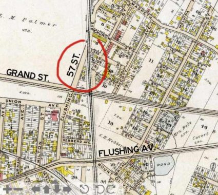
Bromley atlas, 1909.
57th Street in this part of Maspeth was once known as Flushing Avenue and issued north from Flushing Avenue (the other Flushing Avenue, the old Brooklyn-Newtown Turnpike that angled in from Brooklyn) and ran north, crossing the railroad when it was at grade. Yes, there was once a corner of Flushing Avenue and Flushing Avenue, a situation that helped lead to the institution of the Queens street numbering system. (Neither Flushing Avenue actually approached Flushing.)
Exposed Belgian block bricks in Queens streets is a relative rarity. In truth, they’re murder on axles and shock absorbers, and bicycle riders get jolts from them. Yet, they’ve been cultivated in old-timey parts of town such as DUMBO and Greenwich Village, which have even installed new brick surfaces. Here on 57th Street, though, the macadam has simply worn through, re-exposing the old bricks. The street may well have been demapped, which is why Google doesn’t recognize it and the city doesn’t pave it.
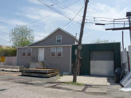
If you look closely at the 1909 map excerpt you will see three small yellow boxes on the east side of Flushing Avenue (57th Street). These indicate wood houses. As it happens, one of them remains, overlaid with layers of siding. In the yard and the street are parked a number of flatbed trucks and machinery.
57th Street now ends abruptly at the LIRR tracks, in the early 20th Century, when the tracks were at grade, it crossed them as Flushing Avenue. These tracks are part of what is known as the “LIRR Montauk branch” though only a couple of passenger trains that use these tracks actually travel as far as Montauk, the easternmost station on the South Fork. These non-electrified tracks are mostly used for freight, but see 3 or 4 passenger trains a day. The white house directly ahead was once home to family members of James Maurice, a 19th Century US Congressman from the area who donated funds to found St. Saviour’s Church, designed by prolific ecclesiastic architect Richard Upjohn, which stood here from 1847-2007. After its land was sold by the Korean congregation that latterly owned it to a developer, the church was demolished and awaits reassembly.


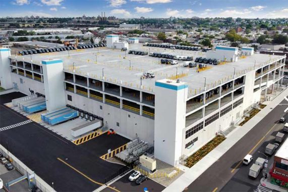
A number of structures on this walk in 2017 no longer exist. Built in 1925 (as indicated by a terra cotta sign at its roofline) at 55-15 Grand Avenue just west of the railroad, the handsome brick Star Corrugated Box epitomized western industrial Maspeth. In its later years it served as a truck depot. After local politicians thwarted Amazon’s plan to build office space in Hunters Point in 2019 (they selected Virginia instead), Amazon purchased the property the following year and quickly razed the box factory and built a 1 million-square-foot delivery station, the bulk of which is dedicated to van storage; you have no doubt seen Amazon’s dark blue vans on NYC streets delivering packages.
At one time in the not too distant past the presence of a delivery station adjacent to a freight railroad would have been a vitally important circumstance; but in the age of trucking the railroad’s impact is absent.
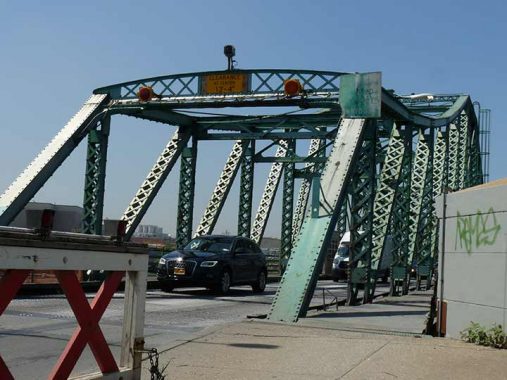


We paused on the Grand Street Bridge spanning the Creek. The route is bridged over two bodies of water, Newtown Creek here, and a newer bridge that takes it across English Kills further west.
Hanging on for dear life, though not, it appears, for too much longer, is the venerable Grand Street Bridge, the oldest of the many bridges spanning the noxious and noisome Newtown Creek and its tributaries. I should do a survey of the Creek bridges while it’s still there.
The bridge passed its centennial with little fanfare in 2002 (it was opened in December 1902 or February 1903, depending on what source you use) and as old as it is, two previous bridges bridged the Newtown before it. The first, constructed in 1875, became dilapidated and un-maintenanced (in a typical NYC and Brooklyn story) and was replaced in 1890, but was declared by the US War Department (now the Department of Defense) as a threat to navigation. Plans for a new bridge, the present one, were drawn up in 1898. My fascination with it never ends from its rickety, swaying roadbed and sidewalks and battered signage to the DOT’s halfhearted attempts to illuminate it with new LED lamps. Views north and south (the distant St. Aloysius Church can be seen from here) are available.
Grand Street and Grand Avenue, as the road is known in Queens, together are about 120 years old. Grand Avenue was engineered in the late 19th Century as an eastern extension of Williamsburg’s Grand Street, and was known as a Street in the early years of its existence before the Queens section became an Avenue, likely to differentiate it from Brooklyn. In Queens, the road’s eastern course overlapped the course of the Newtown Plank Road, which is today’s Maspeth Avenue as far as its eastern junction with Grand and Flushing Avenues. (Flushing Avenue itself is a straightened version of a colonial-era route called the Brooklyn and Newtown Turnpike.)
Plans call for it to be replaced with a modern span, which will no doubt be functional and boring, within a few years. More photos on this FNY page.


There is a right of-way connecting Grand and Metropolitan Avenues east of the tinkertoy bridge used for Western Beef truck parking. In reality this is closed to the public but Mitch “knows some guys” and indeed, conversed with one or two on our way through. This passageway affords unusual views of the creek, bridge and an unnamed inlet (possibly manmade) of Newtown Creek (shown here on google maps).

As presently configured, the eastern end of Newtown Creek is at Metropolitan and Onderdonk Avenues, as is the border between Brooklyn and Queens. The border runs down the center of the heavily polluted waterway for its entire length. The creek formerly was the boundary between the towns of Bushwick and Newtown; Brooklyn annexed the six towns of Kings County in the 1890s and was itself annexed by New York City in 1898, a year that also saw Queens County dissolve its towns when it joined NYC. I have traveled down by boat a few times: this is FNY’s first page on the Creek from 2004.
This extraordinarily large building at 46-25 Met Ave. is a NYC Transit Consolidated Revenue Facility. Since it’s heavily gated and guarded, that’s all that the Department of Transportation wants you to know about this building.


An extraordinary amount of “street art” is found along Metropolitan Avenue between the creek and Gardner Avenue. Some of the street artists have used the M. Fine Lumber Co. building, likely with cooperation of the owners.
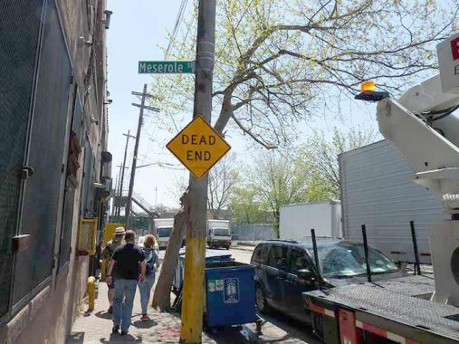


Scott Avenue at Meserole may be a dead end for motorists, but for pedestrians it goes to the extraordinary Scott Avenue Bridge. Actually this was a fortuitous day as these were the last photos I was able to get depicting the original Scott Avenue Bridge, built in 1952 over the Bushwick Branch of the Long Island Rail Road, for decades used exclusively for freight. It would not be the last time our group crossed the railroad. Views are available of midtown Manhattan and east and west on the Bushwick Branch. The old bridge was still lit by incandescent bulbs although I got a closeup view of one of the Cooper Verdeon LEDs that have dominated Brooklyn for about a decade (each borough seems to have gotten their own makes).
By the time I passed these parts again in 2021, a completely new bridge had replaced it; I was unaware that plans were in the works.
Next time: up the Creek to Greenpoint
As always, “comment…as you see fit.” I earn a small payment when you click on any ad on the site. Take a look at the new JOBS link in the red toolbar at the top of the page on the desktop version, as I also get a small payment when you view a job via that link.
9/17/23
3 comments
I enjoy reading your articles. A few years ago I started exploring places on Long Island, NYC, etc. Mostly parks and trails. I liked to ride my bike around and take pictures and post them on my Facebook page. I usually like to give a description along with them. So it’s nice to see I’m not the only person who does this. So thank you for your posts. I also live in Little Neck.
That Amazon delivery station is a design specially adapted to urban areas where space is limited. In less dense areas its new stations are more spread-out ones that have multiple exterior loadout lanes under a canopy, like the new one in Syosset just off the Long Island Expressway.
Love this. One of these days, I’m buying your book! As I mentioned once before, my maternal grandfather , John G. Moller,owned and operated a factory on Newtown Creek. He lived on Grand Street; no house numbers back in 1907. I think they moved to Maspeth from Brooklyn in the early 1900s. My mother was born in the house on Grand Street in 1909. The house was a large , mansard-roofed , 8 bedroom home, which, from what I learned from my mother, her father rented(?) or bought from Cord Meyer. Another family lived close by called Ott or Otten. The Mollers moved to Maspeth because my grandfather wanted to live ‘out in the country’ so his children had a place to play outside. He died in 1916, as a result of a heart attack; he was 50 yrs old. He had imported chemicals from Germany to process glue and mannure , and when The Great War started, he could no longer buy his chemicals from Germany because of embargoes placed by the United States, hence, his business suffered. I think he sold the factory . Their lives were upturned, but not diminished by all of that. Fortunately , my aunts and uncles and my grandmother, Isabella Toal Moller endured and , in many ways, thrived, afterwards. My grandfather is buried in the Lutheran Cemetery on Metropolitan Avenue in Middle Village , not far from the old Niegerstein’s restaurant.