

SUNSHINE is my undecaffeinated coffee, my 5 Hour Energy, my Red Bull. I get more done on days with full sunshine than I do on overcast days; nonetheless, I have completed scouting for FNY pages and tours in every conceivable weather including rain and snowstorms. In over 150 live tours from 1999 through 2019 (and I hope to continue sometime but health will have to cooperate), I was mostly fortunate with the weather. One person, though, who always seemed to luck out with wall to wall sunshine for his own tours was the Newtown Pentacle‘s Mitch Waxman, the longtime chronicler of Newtown Creek and its environs. He always seemed to have full sun for his tours though he, like me, scheduled them weeks in advance. Seeking a change of scenery, Mitch and his wife Catherine moved to Pittsburgh in December 2022, where he continues the Newtown Pentacle despite his new location.
In the April 2017, Mitch, a member of the Newtown Creek Alliance, conducted one of his Newtown Creek tours. It was an all-day affair comprising approximately 8 hours with over ten miles of walking. I accompanied the group on the first leg of the tour, but finding myself hopelessly behind the rest, I decided to call it a day when we got to the now-deceased Goodfellas (originally Clinton) Diner on Maspeth Avenue. (Sometimes I feel I am the only native New Yorker who walks slowly.) A few weeks later, in a walk that included me and filmmaker Heather Quinlan, we mostly covered the remainder of the tour; I will get to that portion at a later date, but today, I will touch on the original Creek walk.
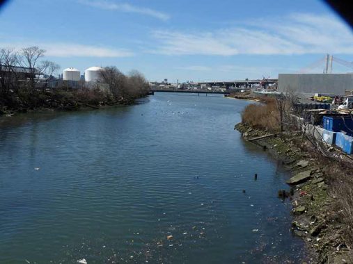
Newtown Creek, a naturally-formed inlet of the East River, was one of the northeast’s first superhighways, in use by Native Americans for untold centuries before the white man arrived in the early 17th Century. Dredging and industrialization ensued, solidifying the Creek in concrete and formalizing its length and those of its tributaries, Dutch and English Kills, Whale Creek and others. Railroads and highways accompanied its length as well. Manufacturing and industry arrived, with rendering of domesticated animals, paint and varnish manufacturing, disposal of scrap metal, and other activities of the Age of Industry. The Creek itself, as well as deep underground in surrounding territories such as Greenpoint, Dutch Kills and Maspeth, were hopelessly contaminated in what many fear to be a permanent condition. Plans are now underway to alleviate the pollution, but will the area ever be made clean again? It may take hundreds of years even if efforts are intensive. Nature is hardy, however, and some fish, crabs, turtles and water birds can be found here. Tall tales abound that large snapping turtles that can hold their breath underwater for lengthy periods are in the Creek’s depths. Newtown Creek has gotten rather cleaner over the past decade but it remains quite toxic.
The tour began near where the Creek empties into the East River. Shown here is a a short stub of Vernon Boulevard which exists south of the Long Island Rail Road tracks just east of the Long Island City station, once an important connection to ferries playing the river, but relegated to a relative system backwater since Penn Station opened in Manhattan in 1910. Seen is the spire of St. Mary’s Church at 49th Avenue, which has been a presence in Hunters Point since 1870. This 1903 church is actally the third church building of the parish on the site: the previous two had been fire victims. On 49th Avenue the church is accompanied by satellite school and lyceum buildings.
Vernon Boulevard, until the 1950s, had gone across Newtown Creek via a steel truss bridge, connecting with Manhattan Avenue on the other side; its former presence is marked by widenings of Vernon Boulevard and Manhattan Avenue on either sides of the Creek. The bridge was replaced by the Pulaski Bridge, connecting 11th Street with Oakland Street (later McGuinness Boulevard) the same decade.
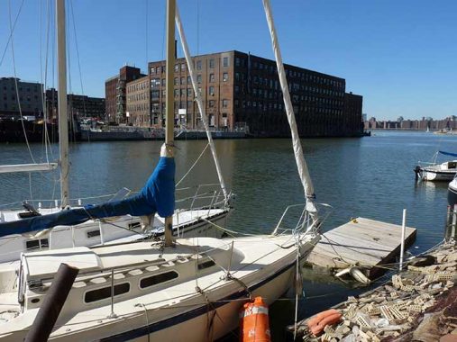


Had we visited this locale on the Creek before the 1950s, the view would have been obstructed by the Vernon Boulevard Bridge. The grand old brick building seen here at Manhattan and Commercial Streets in Greenpoint is the 1868 Chelsea Fiber Mills building, a manufacturer of marine rope. In recent years it has been home to the Greenpoint Manufacturing and Design Center. “GMDC has played a vital role in helping meet New York City’s need for affordable, flexible production space for small and medium-sized manufacturers.”
As we can see Newtown Creek, despite is polluted character, has developed into a center for recreational boating and kayaking. The North Brooklyn Community Boathouse, located across the Creek, regularly schedules organized “paddles” on the Creek.
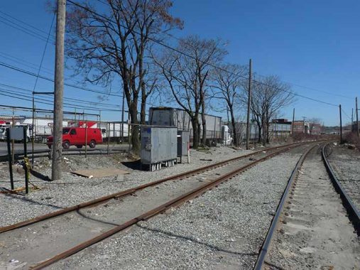
Active railroads, and some deceased ones, accompany Newtown Creek. Here Mitch Waxman exhibits what are likely trolley tracks on Vernon Boulevard; Hunters Point was a western terminal for a number of trolley lines run by Steinway Lines between 1922 and 1939. Occasionally trackage from these lines peeks above worn-down asphalt pavements.


The tour winded beneath the Pulaski Bridge, where a rare grade crossing of the Long Island Rail Road was encountered. The bridge has a handy, but steep, staircase to the street below.
The Pulaski Bridge, opened in 1954, is a bascule bridge in which counterweighted deck members pivot upwards to allow shipping to pass underneath. London’s Tower Bridge is another example of a bascule, albeit a much more ornate one.
General Casimir Pulaski (1747-1779) is regarded as the father of the American cavalry. He was enlisted by Benjamin Franklin in Paris after successfully defending Poland against a Russian invasion and falling out of favor after his implication in a plot to kill the Polish king. He was able to cover George Washington’s retreat at the Battle of Brandywine with expert use of cavalry; he was subsequently awarded command of all US cavalry. In 1779 he helped break the British siege of Charleston. He was mortally wounded at Savannah, GA in 1779 at the young age of 32.
The Pulaski Bridge replaced the Vernon Boulevard Bridge (see above). About 15 years ago the Pulaski received a protected bike lane, which ended the dangerous conditions caused by bikes and walkers sharing the bridge’s walkway.
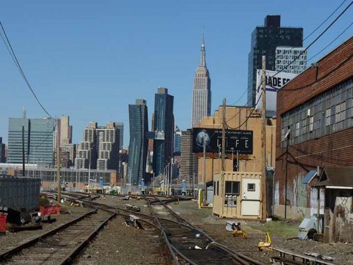
Looking west on the LIRR tracks toward Manhattan’s East Midtown and the K-shaped American Copper Building towers, one of which has an unusual angled design that makes them look from across the East River in Hunters Point as a giant reverse letter K or perhaps a crooked letter H. The two towers are residential, despite their industrial sounding name, and are connected by a pedestrian skybridge. The two buildings do have copper cladding, with both open for occupation in 2018.


Arguably NYC’s busiest railroad grade crossing is on busy Borden Avenue just east of the Pulaski Bridge. I am sufficiently fascinated by NYC’s RR grade crossings, of which just a handful remain, to have done a FNY series on them in 2014.
Borden Avenue was built as a plank road in 1868; at first it extended east only as far as Calvary Cemetery, but by the 1920s, it had been built as a main traffic route as far east at Grand Avenue and 69th Street in Maspeth. When the Queens-Midtown Expressway was built after World War II, Borden Avenue became the service road on the north side of the expressway and it still terminates at Grand and 69th — east of that, the service road is labeled Queens-Midtown Expressway. All service roads change to Horace Harding Expressway east of Queens Boulevard. The name was of a local landholder and has nothing to do with the Borden’s of Elsie the Cow.
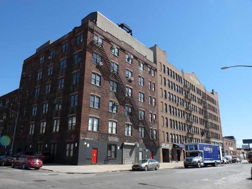
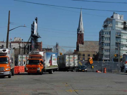
At 21st Street and Borden Avenue are a pair of stolid brick manufacturing buildings of whose type I so admire. The furthest away is the many-windowed Blanchard Building, its U changed to a V by stonecarvers under orders to make the “U” the Roman “V” to impart majesty and permanency. Its upper floors look out on Newtown Creek. In this part of Hunters Point, the residential fever that has taken over the west side of the neighborhood near the East River hasn’t reached its business side. The Blanchard looked across the street at former Fresh Direct depot on Borden.
In a former life the Blanchard was a factory that made fireproof doors and shutters. Some years after a fire started in the Columbia Paper Bag company engulfed it in flames, Blanchard rebuilt, only to merge with the John Rapp Company, becoming the United States Metal Products Company.


I am also a fan of rickety pedestrian bridges. Mitch Waxman Pied Piper’d us across this one at 21st Street that crosses the Long Island Railroad cut. Lollygagging on this bridge, especially on weekday mornings, will allow one to view numerous passing trains en route to the Hunters Point station and points east.
I discovered this bridge quite by accident in 1998, at the dawn of the Forgotten NY era. One morning I desired to take a train from Jamaica to LIC in order to ride one of the last shuttles that employed ancient MP75 passenger cars in use since the 1950s that stopped at every station along the so-called LIRR Montauk Branch, at Richmond Hill, Glendale, Fresh Pond, Haberman and LIC; these stations were being closed because the LIRR was purchasing new cars that required raised platforms, and these stations admitted 0-5 passengers per day and were not worth the cost of installing them. By 1998 these stations were grassless patches along the side of the tracks.
After de-training at LIC I headed up Borden to catch a #7 to Woodside, for a LIRR train back home or to work in Port Washington (I forget which now) but used this bridge that connects the two sections of 21st Street across the tracks and then winds under the elevated Queens Midtown Expressway. I had never seen it before!
North of here, 21st Street becomes a pedal to the metal truck route all the way to Astoria Park, and connections can be made to the Queensboro Bridge. In former times, it was called Van Alst Avenue and a G train station still bears the name.


The former Skyline Diner at 21st Street and 49th Avenue was relatively clean (on the outside) in 2017, but the interior was a mess. It was briefly a hot ticket over a decade ago when the upscale diner M. Wells briefly occupied it. It has sat lonely since then. More on this 2022 FNY page.
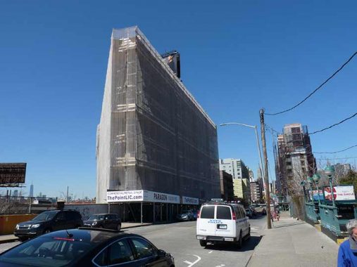
Across the street from the diner is the wedge-shaped Paragon Oil Building. The scaffolds have since been removed. It has a lengthy history, including a stint as Queens Borough Hall.


49th Avenue and 21st Street is a potential transit hub…if the MTA would only take advantage. Here we have the #7 Flushing Line Hunters Point Avenue station, and alongside it, the LIRR Hunters Point Avenue station, open only for a few trains weekdays in the mornings and evenings (I have yet to research if the new LIRR Grand Central service has impacted its schedule). These two stations can be connected to create a mini transit interchange; already, when something is wrong with the #7, the LIRR has set up shuttle service from Flushing to Hunters Point.


Mitch points to an end bumper for railroad tracks at Hunters Point Avenue and 27th Street; but today no tracks remain. This one served a track spur for a private railroad known as Degnon, after its builderMichael Degnon. The LIRR absorbed it in 1928, and while all official rail activities ceased here in 1985, it’s still possible to run trains on some of the trackage; the connection at the Montauk Cutoff has been preserved.
Trains would connect from these tracks via a routing from the Sunyside Yard over the Montauk Cutoff overpass over Skillman Avenue just north of 49th Avenue, and would run on a trunk line along Skillman and 47th Avenues with spurs along many of the side streets. This small freight line served warehouses of NYC’s great department stores such as Gimbels, Kleins, and Macys; some of their names can still be seen on buildings. Sunshine Bakeries, American Chicle gum and Swingline, with its famous neon sign were here as well. Swingline decamped to Mexico in the mid 1990s.
After forming the Degnon Construction Company in Cleveland in 1895, Michael Degnon (1858-1925), whose chief line of construction was in railroads, moved his headquarters to New York in 1897. The Degnon Company built many of the IRT’s early subway tunnels in Manhattan and Brooklyn from 1904-1908; the Steinway tunnels originally meant to carry trolley cars but later fitted for subways; what is now known as the PATH tunnel under 6th Avenue; and much of the original Pennsylvania Station.
The rising cost of doing business in New York forced all of the companies served by the Degnon RR to find other cities in which to manufacture, and the Degnon tracks in Sunnyside were defunct by the end of the 1980s. Degnon’s railroad works around the country are also numerous.
Back in 2010 I was rather rhapsodic about the handsome building, just north of Hunters Point Avenue at 27th Street. Good gravy, see the way it looks in 2023. Renovated top to bottom again but this time clad in gun metal gray, with all the extra ornamentation removed.
It was built in 1917 as the Marcus Ward Building.
[This] stationery manufacturer and printing company was established in 1848 in Belfast, Ireland. Originally known as John Ward & Sons in the first half of the 19th Century, the company grew from a small paper mill into a successful color lithographer, specializing in Victorian-styled calendars and greeting cards towards the end of the 19th Century that garnered international reputation, moving to London by the end of the 1800s. At the turn of the 20th Century, as satellite branch was established just outside of Bush terminal on 29th St in Brooklyn, where Ward remained until completion of this site and the beginning of 1917.
This site, housing the company’s main manufacturing plant and company headquarters, employed between 150 and 200 people in the first decades of early 20th Century, while maintaining permanent salesrooms at 200 5th Ave in Manhattan, as well as sites in Chicago, Philadelphia, and San Francisco. Several of Ward’s brands during the early 20th Century were marketed towards the higher classes, with brand names such as “Gentlemen’s Writing Paper” and “Gentlemen’s Stationery,” white paper made from both parchment and bond paper, as well as Irish linen and Irish poplin. Other brands included the “”Papeterie des Tuilieres,” rose, blue, and pink envelopes embossed with a gold-colored four-leaf clover. By the early 1940s, however, the nearby Henry Waldes Company, also known as the Waldes Koh-I-Noor Company and initially established on 27th St and Austell Pl, purchased the facility, as well as several other factories in the immediate area, owning this building until at least the late 1970s.
During this time period, the building also housed Kelvinator Corporation, a national home appliance manufacturer specializing in refrigerators. Founded in Detroit in 1914 by engineer Nathaniel Wales, the company took its name from Lord Kelvin, the founder of the mathematical concept of Absolute Zero. Wales introduced the world’s first refrigerator with automatic controls in 1918, and within five years, his company controlled 80% of the home refrigeration market. In the mid-1930s, the company unveiled its Kelvin Home design, one of the earliest attempts at mass-produced residential air conditioning and heating. During World War II, the entirety of the company’s operations were converted to military production. After a series of corporate acquisitions in the latter half of the 20th Century, the Kelvinator name continues to grace products across the globe. Currently, a film archival company known as Paramount Antiques leases space inside the factory. [Comments, Sunnyside to Hunters Point, FNY 11/1/2020]


The Hunters Point Avenue Bridge, which crosses Dutch Kills, opened in 1910, is a vehicular bascule bridge that replaced two earlier bridges, made of wood and then iron. It is two years younger than the neighboring Borden Avenue Bridge, which is one of four retractile bridges remaining in the USA. It celebrated its centennial in 2010, though it had been largely renovated in the 1980s.
Seldom commented on, the Hunters Point Avenue Bridge segments Dutch Kills neatly, and has done so for [over] a century now. The marshes and streams which once typified the area before the advance of railroad and vast agglutination of industrial installation are long gone, relegated to subterranean sewers and masonry clad spillways, but a century ago the Hunters Point Avenue Bridge (and its predecessors) allowed egress between the terrestrial isolation of the Long Island City center and the rest of western Queens. Newtown Pentacle


The group then headed south on 27th Street to Borden Avenue to cross the ancient Borden Avenue Bridge, built in 1908 and one of four retractile bridges in the country and one of two remaining in NYC. To save time writing this page, I’ll refer you to FNY’s post from 10/18/2011, which details its geography, technology and history.


After about a mile’s work of walk south on Review Avenue, another LIRR grade crossing was found, this time at the section of Greenpoint Avenue that crosses the tracks beneath the J.J. Byrne Bridge. The bridge, also known as the Greenpoint Avenue Bridge, was opened in 1929 and was completely overhauled in 1987. It is the fifth bridge that has carried Greenpoint Avenue over Newtown Creek. It is a bascule drawbridge as is the Pulaski Bridge.
According to the Department of Transportation, a drawbridge first operated here in 1855, constructed by Neziah Bliss (1790-1876), who founded the neighborhoods of Bayside and Hunters Point on either side of the Creek; one of its successor bridges also carried a defunct section of the Long Island Rail Road from the Greenpoint waterfront to a connection with the similarly-vanished Evergreen Branch.
In 1950, in what is considered to be the worst oil spill in United States history, 17 to 30 million gallons of oil spilled into Newtown Creek. Oil is believed to have been seeping into the groundwater since then. Groundwater in this area is not used as drinking water, as all of New York City’s drinking water presently comes from upstate reservoirs.


The stub of Greenpoint Avenue allowed access to an unmarked road running along the tracks adjacent to the Creek. It is unlit by streetlamps and unmarked by street signs, but is called Railroad Avenue on Google and Open Street Maps. It stretces for about a mile and is the access road for metal recyclers Prince Metal and Sims Metal. It also allows close-up views of the railroad tracks, which are used by relative few freights during the week. Busy passenger lines once used these tracks, but that was decades ago.
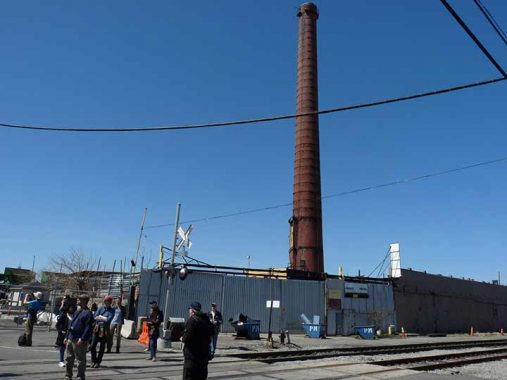
Until 2022, a lone smokestack remained on Railroad Avenue from the Van Iderstine rendering plant, described in this FNY post.


2017 was a transitional year for Creek crossing, as that was the year the first Kosciuszko Bridge was replaced by the first span of the new one. For about a year, new and old stood together. After the original K Bridge, constructed in 1939, was disassembled, the second span, which admitted pedestrian and bicycle traffic, was completed 80 years later. At night, the twin cable-stayed spans put on a light show.
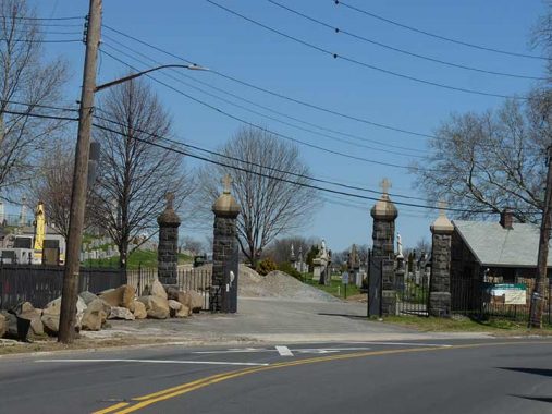
This was originally the main entrance to Calvary Cemetery on Linden Hill Boulevard, but is now pretty much the back door in. In the mid-19th Century Manhattan was getting so crowded (by 1845 the island was fully built up south of about 42nd Street) that it was running out of cemetery space. The two largest cemeteries had been developed by Trinity Cemetery, in the churchyard adjacent to its ancient Broadway and Wall Street location, and uptown in the furthest reaches of civilized Manhattan territory, the wild north of 155th and Broadway.
By the 1840s Brooklyn’s largest cemeteries, Green-Wood and Most Holy Trinity, and Woodlawn in the Bronx were accepting interments; and in Staten Island there was Moravian, developed in the 1760s, and myriads of smaller cemeteries.
Queens, too, had dozens of tiny burial grounds scattered around, many dating to the mid-1600s. In 1847 the Rural Cemetery Act was passed, prohibiting any new burial grounds from being established on the island of Manhattan. Presciently anticipating the legislation, trustees of the old St. Patrick’s Cathedral on Mulberry Street in what is today known as Little Italy began buying up property in western Queens. Calvary Cemetery, named for the hill where Christ was crucified, opened in 1848. The original acreage had been nearly filled by the late 1860s, so additional surrounding acreage was later purchased to the east.
The original Calvary Cemetery lies between the Long Island Expressway (formerly Borden Avenue), Greenpoint Avenue and 37th Street, Review Avenue and Laurel Hill Boulevard. New Calvary, in three divisions, is west of 58th Street (formerly Betts Avenue) from Queens Boulevard south to 55th Avenue. Smaller, pre-existing cemeteries were part of the original acreage, and were then surrounded by Calvary.
My most recent visit within was with Mitch Waxman in November 2022.
This is all that remains of what was once the Haberman LIRR station at 56th Road and 49th Street, formerly known as Debevoise Avenue. According to the late LIRR historian Vincent Seyfried the station originally opened in 1892 and was named for the Haberman Steel Enamel Works in Berlin Village, a name formerly applied to this section of town, which featured a number of German immigrants.
Maspeth Creek, a man-made, or man-straightened, inlet of Newtown Creek can be found in this view from 49th Street south of the tracks.


Here we are standing on the west end of 58th Road, attained from 48th Street, in a no-man’s land (except for the many industrial concerns located here) at the far west of Maspeth, a block north of the ancient Grand Street Bridge, looking across to Brooklyn, where Maspeth Avenue can be seen on the other side.
The pilings and pier remnants are reminders that the Maspeth Plank Road, a connector from the City of Williamsburg(h) to Newtown once spanned the creek, but not since … 1875, though the bridge can still be found on maps from the early 20th Century. The giant Maspeth gas tanks could once be seen from this vantage, but they were imploded in a controlled explosion in July 2001 — an eerie precursor to events two months later. 58th Road is a remnant of the Maspeth Plank Road, which is represented by Maspeth Avenue (which was redirected several decades ago and no longer follows its former plank-paved route here).
I’m surprised that access to the Creek is so easily attained here; the pathway is rocky and slippery, and one can easily lose footing. However, it’s considered a historic landmark and a descriptive sign has even been installed.


For me one of the crown jewels of the Creek is the Grand Street Bridge, built between 1900 and 1902. While the other Newtown Creek bridges are relatively bland products of the mid-to-late 20th Century and are quite boring in aspect the Grand Street Bridge is a swing bridge that looks like something you would put together with an erector set when you were a kid. It swings and sways when you are crossing it by foot. For years I have heard about the city’s plans to replace it, but here it still stands.


Maspeth Avenue crosses the tracks here at yet another grade crossing.
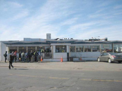


The Clinton Diner, at 58th Street and Maspeth Avenue, was one of a vanishing breed of roadside diners, catering to workers in an industrial area and motorists who are passing through. It stands next to freight tracks of the Long Island Rail Road. DeWitt Clinton’s mansion, for which the diner had been named, stood nearby until 1933. A house belonging to family members of mid-19th Century Maspeth mover and shaker James Maurice is across the street. Community meetings took place here, and it had been used on numerous occasions for movie and TV shoots when a scene needs authenticity. One of those was the film Goodfellas where a scene with Robert DeNiro and the late Ray Liotta was filmed; diner owners the Diamantis family renamed the Clinton Diner Goodfellas Diner in its honor. Other TV shows such as the Good Wife, Six Ways to Sunday, the Americans, and Elementary also filmed scenes there. The diner’s location on a main truck route, its isolation, and its 1960s decor made it irresistible to directors searching for period atmosphere.
The fun ended in June 2018 when a devastating fire gutted the diner’s interior. The diner still stands, with plywood instead of windows. After initial indications from the Diamantis family, which owned it, that the diner would reopen, it hasn’t happened. Google Street View shows a blur in its place.
The group had stopped for lunch here and I decided to call it a day and head for the bus in Maspeth. As stated previously I would complete the tour with Mitch later in the month, under ideal weather conditions once again.


Walking along 58th Avenue between 58th Place and 59th Street (in Maspeth the street numbering is all between 55 and 60) I spotted something unusual: what appeared to be an updated and modernized version of the metal medallions honoring members of the Organization of American States along 6th Avenue (the Avenue of the Americas). In 2017, my presumption was that someone living in the area liked the signs and installed a homemade version.
Fast forward to 2023 and came the news that the Department of Transportation was producing new versions of some of the signs and reinstalling them along 6th Avenue. And, a little investigation produced the news that the DOT has a sign shop nearby in Maspeth. Thus, what I saw here was a trial installation of one of the new signs. A check on Google Street View shows it wasn’t on this lamppost for very long at all so it was pure luck stumbling on it that day in April 2017.
At 69th Street and Grand Avenue was waiting the Q18 bus back to the LIRR in Woodside. Rather, I was waiting; they don’t run them very often.
As always, “comment…as you see fit.” I earn a small payment when you click on any ad on the site.
3/5/23
9 comments
Kevin, to answer your question about LIRR service to and from Hunterspoint Ave., there are still eleven AM trains (arriving between 6:32 and 9:28 AM) and nine PM trains (departing between 3:30 and 6:53 PM). While it is likely that their ridership numbers have plummeted west of Jamaica because of the new LIRR Grand Central service, the trains will continue to run because (1) they still must travel to Long Island City Yard for storage and servicing between the rush hours; (2) there are some people who use those trains who work in Long Island City; and (3) they originate/terminate at stations beyond electric territory – Port Jefferson, Oyster Bay, and east of Babylon and still must carry riders to/from Jamaica, who connect for Penn, Grand Central, and Brooklyn.
Last time I was there in the AM rush hour, in 2019, there were a number of private vans and small buses waiting for LIRR commuters, who no doubt worked in the surrounding area. The trains are diesels, not electrics, and cannot travel through the tunnels that access the Manhattan terminals.
When the Amazon Headquarters was announced in 2019 it seemed like a perfect match – LIRR trains with excess capacity could bring workers to the proposed location. Unfortunately, the idea was killed along with the jobs it would have created.
You know who is responsible for the cancelation of your “perfect match”. And after Rome (i.e. the Amazon HQ proposal) burned here’s what the diva responsible for this stillbirth was fiddling with:
https://nypost.com/2023/03/05/aoc-begged-to-go-to-met-gala-even-if-it-meant-breaking-the-rules/
In fact, the LIRR diesels are “dual mode” and can convert to electric power for short distances, as the Metro North diesels do when they are south of 125th Street. There are a few arrivals and departures of those dual modes at NY Penn Station, but fewer than to/from Hunters Point or LIC, I believe. The reason those locomotives don’t go to Penn likely has more to do with the convenience of staging them at LIC rather than laying them up in West Side Yard or using them to make a return trip from/to Long Island as a relay without laying up.
The tunnels used for the approach to Grand Central Madison are not large enough to accommodate the diesels and bilevel cars, since it was built to the specs of the electric cars which were similar to the BMT/IND cars.
Half of the LIRR diesel locos are dual mode, and half are conventional and cannot use third rail power. Remember also that dual mode trains in and out of Penn need two locos – one at either end – to prevent gapping on the third rail.
The proposed Amazon headquarters in Queens was not in AOC’s congressional district. It was in
Carolyn Maloney’s.
No, I believe it was Mike Ginariis district
The proposed Amazon HQ was in Mike Gianaris’s NY State Senate District. It was in Carolyn Maloney’s US Congressional District at the time. Ocasio-Cortez represented an adjoining District, but has represented that area since the re-districting of 2020. That Amazon pulled out is the result of efforts by both Gianaris and Ocasio-Cortez.
Nice piece Kevin. Do those LIRR freight tracks interconnect with the Bay Ridge Branch?
No not directly