
JACKSON Heights is not named for President Andrew Jackson, as might be assumed. Instead, it’s named for the man who built Northern Boulevard. Northern Boulevard was built in 1859, and opened to traffic in 1860, between what is now Vernon Boulevard and the Flushing River by the Hunter’s Point, Newtown and Flushing Turnpike Company. It connected to roads further east past the Flushing River, but the newly built stretch was named Jackson Avenue for the turnpike company’s construction supervisor, John C. Jackson. By 1920, most of the road had been renamed Northern Boulevard, with the westernmost section between Vernon Boulevard and Queens Plaza retaining the old name. There is an existing original Jackson Avenue milestone at the Queens Historical Society in Flushing.
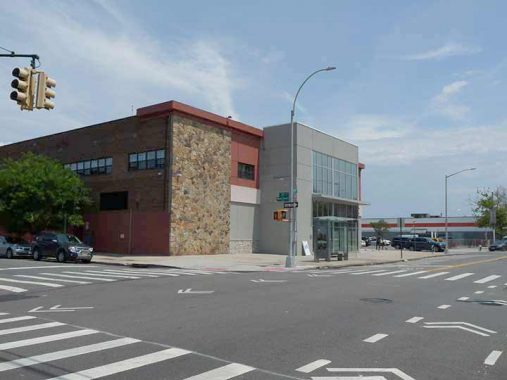
I took a quick walk through Jackson Heights in the summer of 2022, and found some items of which you may be unaware. I found this edifice whose design I found unobjectionable for a newer building, as I liked the stone exterior combined with glass as well as the red trim. Perched on the edge of a shopping mall (the envy of anything I have in my immediate area in Little Neck; I often get shopping mall envy), its tenants are a Child’s Place Academy and a Petco pet supplies store.
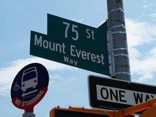
Mount Everest is the tallest mountain in the world at just over 29000 feet (about 8849 meters) and sits on the border of China and Nepal, the mountain George Mallory died trying to climb in 1921 and of which Sir Edmund Hillary finally achieved the summit 30 years later. It’s also 7,530 miles from New York City as the crow flies. So why is the corner of 75th Street and 31st Avenue marked “Mount Everest Way,” as it has been since 2019?
The answer is the increasing numbers of Nepalese who make Queens their home. So many, in fact, that Nepalese has been added to the lists of languages translated at nearby Elmhurst Hospital, which is increasingly becoming “The World’s Hospital” just as the #7 Flushing Line is known as “The International Express.” I was sewn up at Elmhurst in 2011 after tripping on a too-high curb and bashing my head on a guardrail after an ill-advised Metropolitan Avenue Bridge crossing.
Forgotten NY has touched on this subject before, by spotlighting the United Sherpa Association in Elmhurst at 41st Avenue and 75th Street. Then, I wrote:
The Sherpa are best known for their services as mountain guides and the provision of assistance to adventurers climbing Himalayan peaks. Tenzing Norgay, likely the most widely-known Sherpa in history, aided Hillary, the first European to attain the peak of Everest, the tallest mountain on the globe. The Sherpa language is unique to the region they inhabit, but can be written using the Tibetan language or Dravidian script used widely in the Indian subcontinent.
Prior to the mid-1990s, there had not been much Sherpa immigration to the New York City area, but a small coterie gained a foothold and established the United Sherpa Association of the USA (I’ve never heard it mentioned, but “The USA of The USA” can get somewhat awkward, no doubt) in 1996, with just a handful of members. A few years after that, a former Christian church constructed in 1947 at 41st Avenue and 75th Street was purchased for the group’s headquarters. Today, NYC’s Sherpa community numbers about 2,500 people, which sounds like a modest number, but is actually the largest number of Sherpa to be found outside of Nepal.
Just about every corner of the world is represented in NYC.
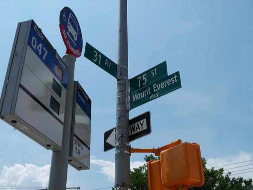
The Metropolitan Transit Authority no longer posts paper schedules at bus stops (which many didn’t believe but I found reasonably reliable). Instead, you’re supposed to get the MTA app on your smartphone and check that. In a concession that many still don’t use smartphones (I used a flip phone till 2015 and still use an IPhone 7 I was sent by a Forgotten Fan) the MTA has installed bus stop indicators that display how many minutes remain until the bus arrives. However, they aren’t universal and my guess is they were installed at every 3rd or 4th bus stop.
Here you have a 45 minute wait for the Q47 and may as well walk.
I have mentioned the distinctive Donald Deskey designed SLECO lampposts often in FNY, as new ones ceased production in the late 1970s and so the numbers you see in the streets now can be considered antiques like me, as many are as much as 60 years old. The design was first introduced at Broadway and Murray Street in the City Hall area in 1958 and production really ramped up in 1962, as the Deskey not only made its way to neighborhood but became the lamppost of choice on many parkways and expressways (they have since been supplanted there by cylindrical shafted Flagpoles lampposts).
Though a squarish fire alarm light indicator had been settled on many of the DOT’s servicers simply plopped the previously used silo deign, basically a plastic orange cover over a light bulb, atop the shaft. Neither design really rested well there and many had to be held in place by tape. However, these are no longer serviced, as the fire alarm lamps, small red cylinders, are now mounted atop the light fixtures as you can see in the zoom out. (That method id inefficient, as the streetlight often overwhelms the small red light).
Every so often when I’m in Jackson Heights, I make my way over to 31st Avenue and 81st Street to see how the Crooked House of Jackson Heights is doing. It’s a tidy, well kept private dwelling on the northeast corner of the somewhat busy intersection. I have no idea who owns it. Instead of facing either 31st Avenue or 81st Street, it instead is positioned in a diagonal fashion toward the corner. Not a whole lot of private homes are positioned like this. I call it the Crooked House of Jackson Heights. (When I was in school and laying out the school paper, I was just getting used to using a T square and Gary, a fellow editor, called me “The Crooked Man” as I had trouble getting everything straight. These days, there are no Crooked Men since layouts are done with computer software. And my alma mater doesn’t even have a paper any more.)
The unique positioning gives the house a rather substantial front lawn facing the corner. Usually, when a house is unusually positioned there’s a story behind it and in this case that’s no exception.
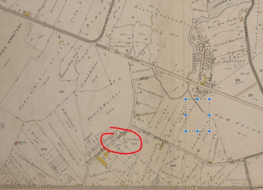
Here’s a 1909 map excerpt of Jackson Heights (ignore the blue box; a mistake I made when screen shotting it). Amazingly what is now Jackson Heights remained undeveloped well into the 20th Century and presented a somewhat wide expanse of sparsely populated meadows between the towns of Long Island City and Flushing. That all changed in the late 1910s and into the 1920s when the Queensboro Corporation built the grand apartment buildings Jackson Heights is known for today. The street grid was then filled in and houses arrived and by WWII, Jackson Heights was fully built out.
But in 1909 only a few roads and a couple of trolley lines crossed what was then called Trains Meadow (the derivation is unclear). At the bottom of the map is Jackson Avenue (Northern Boulevard) and at the top, the Astoria-Flushing Turnpike (Astoria Boulevard). The part of “Old Bowery Road” that hosted a streetcar line to North Beach survives, as Jackson Mill Road (though the mill is long gone).
But the road cutting northeast, Trains Meadow Road, has left little trace. The road itself was laid out as early as the 1670s and ran from Woodside to Flushing Bay originally, but as the overall grid was built the road ceased to be important and fell into disuse (though had it survived it would have made a good shortcut through the area).
Of the homes built along Trains Meadow Road, few survive…one being our house at 31st Avenue and 81st Street, which once had a Trains Meadow Road address but is now plain 80-19 31st Avenue.
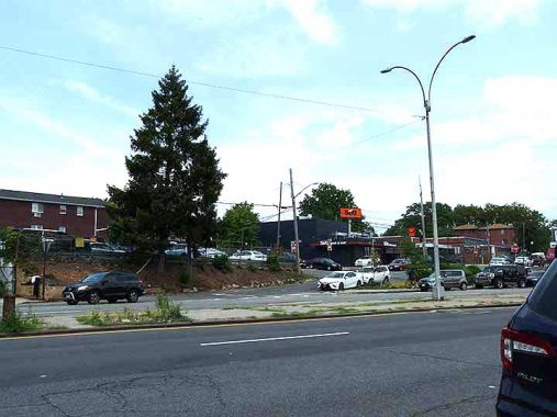
I have never walked the full length of Astoria Boulevard, from the frozen-in-time but un-Landmarked Astoria Village east to its junction with Northern Boulevard in East Elmhurst. It’s a shame because there are several items of interest, from the Airline Diner (seen on this page) to the Dwarf lampposts at LaGuardia Airport to St. Michael’s Cemetery. The stretch here, where East Elmhurst meets Jackson Heights, contains some interesting items as well. I hope to make that walk sometime soon.
Astoria Boulevard shows up on maps as early as 1852; it was likely in existence before that. It was known as Flushing Avenue and had the same route as today, but connected with Flushing with a road through the marshes where Citifield is today, and was bridged over the Flushing River to Broadway (now Northern Boulevard) in downtown Flushing. In the 1930s, the stretch between 31st and 80th Streets became the north and south service roads for the Grand Central Parkway. The eastern end of Astoria Boulevard once faced the Flushing Bay waterfront before landfill moved it north.
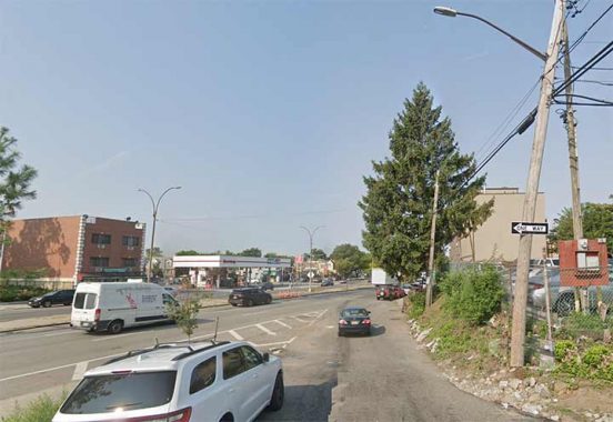
Though Jackson Heights and East Elmhurst are completely built up now, that wasn’t entirely the case into the mid-20th Century. Some signs of that persist, like a sidewalk-less 25th Avenue at 90th Place east of Astoria Boulevard.
One Room Schoolhouse Park, Astoria Boulevard and 90th Street, sits on a .14 acre plot that was home to the schoolhouse mentioned in the park’s name, PS 10, from 1879 to its demolition in 1934. Before receiving the designation PS 10 it had been known as Frog Hollow School, and it remained a school through 1910 (by some accounts, 1925).
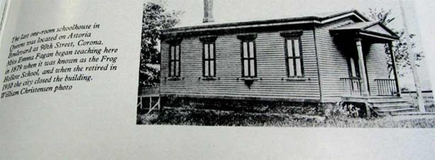
Before the construction of massive apartments by the Queensboro Corporation and its remaining Jackson Heights in the early 20th Century, the neighborhood was a swampy meadow home to occasional homes and traversed by only a few roads: Flushing Avenue, now Astoria Boulevard; a toll road built in the 1850s by John Jackson and named Jackson Avenue before becoming Northern Boulevard around 1920; and by Trains Meadows Road, a diagonal country road of which there are few remnants today.
After the school’s demolition in 1934 NYC Parks acquired the property, and turned it into a playground with swings and other kiddie entertainments. A renovation decades later in the 1980s removed the playground furniture and turned it into a grassy area with benches. In 1996 NYC Councilmembers John D. Sabini and Helen M. Marshall drafted a bill naming the park for the one -room schoolhouse, and Mayor Rudy Giuliani signed it in 1996.
Had the schoolhouse survived a few decades longer, it would have been likely disassembled and put back together as a museum piece. Sick transit, Gloria.
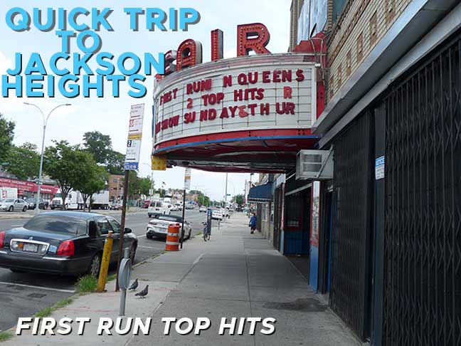
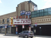
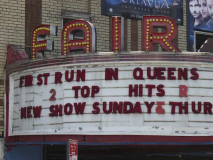
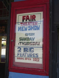
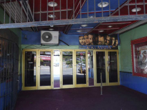
The jewel of the North Shore of Queens, the Fair Theater, is a 600-seater that opened on December 25, 1937 with a double feature: “Dead End” with Humphrey Bogart and a Bing Crosby musical, “Double or Nothing.” It was never part of a chain and showed movies a bit past their expiration date at a cut rate price. It was named in anticipation of the 1939-World’s Fair opening a mile or so away.
Over the years the Fair evolved into a grindhouse and a porno palace servicing the raincoat brigade, but in recent years it has played up some new fare: Indian and Asian action/kung fu flicks. There will always be a somewhat shady aspect to the place, and a New York Post article in 2007 reported that it still was showing porno flicks, but that was years ago. There was a lawsuit in the past from an adjoining storefront church.
That could be the reason that in 2015, the manager, seeing me skulking about with a camera, inquired why I was taking photos. I replied that I could take all the photos I wanted from a public sidewalk. (A similar incident occurred with a goon at the Pomeroy Restaurant on Ditmars Boulevard, who I got into a nose to nose argument a few years ago over the same issue. I complained on the restaurant’s website, and the owner offered me a free meal, but I didn’t take him up on it.)
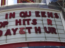
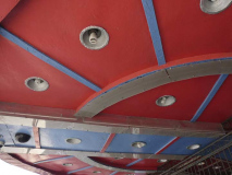
The theater boasts a classic marquee with plastic lettering, but the management doesn’t seem to know what to do with it, since it apparently hasn’t been touched in years and some letters are sagging or missing. The neon FAIR sign does still work, as attested by the theater’s website linked above.
This is one of the last classic marquee/neon theater facades remaining in NYC, and the Landmarks Preservation Commission should at least be inquiring the owner about it.
This stretch of Astoria Boulevard seems frozen in time from at least 1965. The Stella D’Argento (Silver Star) Restaurant, adjoining the Fair with picture windows, shuttered blinds and odd, pentagon-shaped door windows, is “closed for renovations” and promised a January 2023 opening; but the same handlettered sign promised a January 2016 opening when I was last in these parts. If there’s any movement on this front, let me know in Comments.
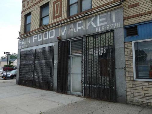
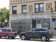
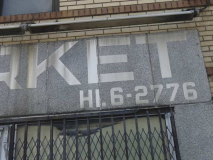
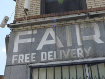
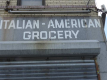
At 91st and Astoria is the long defunct Fair Food Market, an “Italian-AmericanGrocery.” Its 1950s or 1960s linoleum sign is preserved as if in amber, with a HIckory telephone number.
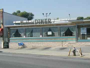
Dueling Diners: The Buccaneer Diner, on the NE corner of 93rd Street and Astoria Boulevard, was once in close competition with the Deerhead Diner one block away at the northeast corner of Astoria and 94th Street, a main route heading to LaGuardia Airport. The Buccaneer won out and survives today; the Deerhead closed in 2000, to be replaced by a dry cleaners.
Heading south now on 94th Street to get to the #7 train, I passed a road I have always had a fascination with, Jackson Mill Road, which like Brooklyn’s Sheepshead. By Road exists in two pieces that were once connected. This surviving bit runs for 4 blocks between 93rd and 97th Streets north of 32nd Avenue; another piece runs from 95th Street northwest to 94th Street and 25th Avenue, and the road’s survival can be discovered on that portion from now-defunct trolley tracks that formerly went to the North Shore amusement areas that are now buried under LaGuardia Airport. For s time the trolleys went to LGA itself before service ended in the 1940s.
Jackson’s Mill was not named for either Andrew Jackson or John C. Jackson, but rather for Samuel Jackson, who owned the titular 19th Century mill on Flushing Bay. Sergey Kadinsky has the full Jackson’s Mill story here.
The triangle formed by Jackson Mill Road, 32nd Avenue and 94th Street is called simply Veterans Plaza.
Parks acquired this property in portions between 1928 and 1932. In 1935, a resolution by the Board of Aldermen (predecessor to the City Council) named the property Veterans Memorial Park of Elmhurst Manor in honor of the soldiers who gave their lives in World War I (1914-1918). In 1997, Parks Commissioner Henry Stern renamed the park Veterans Plaza. NYC Parks
Stern was usually wittier when naming parks, but not this time.
Junction Boulevard and 94th Street could be considered the west edge of Corona, so it’s appropriate that Intermediate School 227 (what we used to call “junior high”) has been named the Louis Armstrong School for Satchmo, one of jazz/pop’s greatest trumpeters and goodwill agent for six decades. Tim Payne’s murals here were first painted in 2009; Armstrong was a Corona resident from 1943 until his death in 1971, and his home has since been converted into a popular museum honoring his life and work.
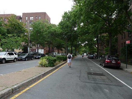
34th Street between 69th Street and Junction Boulevard runs through the middle of the Jackson Heights Historic District and has boasted a center median for decades. For a couple of years, motorized traffic has been prohibited thereon as part of a Department of Transportation “open streets’ project.
As always, “comment…as you see fit.” I earn a small payment when you click on any ad on the site. Take a look at the new JOBS link in the red toolbar at the top of the page, as I also get a small payment when you view a job via that link.
9/3/23

15 comments
Along with a few other groups such as the Indians of the Bolivian Altiplano, Sherpa women are able to reproduce safely at high altitudes. Normally, preggo women should not spend more than a day at a time at altitudes over 12,000 feet due to the risk of complications. Sherpas et al have no such restrictions.
I can attest the Buckeneer Diner has good food and good parking – and a few mintures from western Queens via 31 Ave!
$1.00 movie theatres used to be all over the country but faded out in the 90s.It was a gimmick
to get you in the door as theatres make their real money in the concession stand,not the admission
price.The St. Marks Theatre on 2nd Ave. was one and I spent many a afternoon there watching
such fare as Billy Jack and The 7-Ups.They would also occasionaly show furrin films too.They
even showed Midnight Cowboy once and at the time it was over 5 yrs old! Hey,anything to make
a buck.The clientele there however often left a lot to be desired.
$1.00 movie houses that showed ”stale” movies like the place above used to be
all over the country but seemed to have faded away by the ’90s.The gimmick was
to get you in the door as theatres make their real money on the concession stand,
not the admission price.The St. Marks Theatre on 2nd Ave.was one and I spent many
a afternoon there watching such fare as Billy Jack and The 7-Ups.They were unique
though in the fact that they also showed obscure “furrin” films too.Stale but furrin nonetheless.
They even once showed Midnight Cowboy and at the time that movie was over 4yrs old!.
Hey,anything to make a buck.Their clientele though was not always the best.
I would imagine that it was Northern Boulevard that Jay Gatsby and friends drove for the western leg of their journey through Queens to get to the 59th St. Bridge. I wonder if there really was a sign with spectacles and eyes somewhere en route.
Good Morning – About the corner of 75th and 31st Ave…….I grew up right near there. I have memories of the shopping center that go back to the 1960s. Please look at the east side of 75 north of 31 ave.
You will see three new houses constructed in the 1990s. They face 75 st. Yet they are in line with the rest of the mall. Why is that? There used to be lights and instruments in that spot for the LGA flight path. I guess they no longer needed them and instead of building stores they built homes…..facing the ‘other way’ from the stores. BTW, the edifice that you describe used to be Dante Caterers. Numerous relatives of mine had their wedding receptions there.
Another reason why it’s not named for Andrew Jackson was also because he never lived in NYC itself, so it wouldn’t make sense to name it after him.
Neither did most other presidents, but it didn’t stop anyone.
https://forgotten-ny.com/2019/02/the-presidents-of-new-york-city/
Jackson Heights is a classic example of an outer borough NYC neighborhood that owes its existence to the great subway expansion (the Dual Contracts) that was hatched before World War I and was largely completed by 1931. In 1913 NYC government entered into two agreements (hence, “Dual Contracts”) with two private companies, the IRT and BRT, to vastly expand the subway and elevated system to allow underpopulated areas such as Queens to attract new development, and to permit overcrowded and unhealthy older neighborhoods, such as the Lower East Side, to shrink. Between 1915 and 1931 a whole network of new routes opened, including the then-named Queensboro Line connecting Manhattan with Corona, Queens, by way of Jackson Heights, beginning in 1917. The BRT was reorganized as the BMT in 1923, and both firms were given the right to operate trains on the Corona route, resulting in a unique joint operating scheme. In 1928 the line was extended to Main Street, Flushing, and in 1949, nine years after the City bought out both firms, the joint operation ended and the line, today’s #7 route, became solely an IRT operation.
The new subway service was the catalyst for the Queensboro Corporation’s apartment developments in Jackson Heights; “Heights” was added to Mr. Jackson’s name to signify that the neighborhood was designed for people of means, not due to its altitude. Indeed, Jackson Heights became unique because in 1925 Manhattan’s Fifth Avenue Coach Company created a new route connecting its namesake avenue with Jackson Heights, crossing the Queensboro Bridge and travelling on Queens Boulevard and Roosevelt Avenue. The bus route (originally #15 and today Q32) marked the first time the Fifth Avenue firm expanded out of Manhattan. Because the firm’s buses were double decked, charged ten cents (versus the nickel for the subways), and did not permit standees, its buses were marketed as a high-end alternative to subway travel, aimed at Jackson Heights matrons who wanted a direct trip to and from Fifth Avenue department stores without the hassles of carrying packages on a crowded subway.
More detail about the history of Jackson Heights can be found in this article from Wikipedia:
https://en.wikipedia.org/wiki/Jackson_Heights,_Queens
In his book “Into Thin Air” (referring to the dangerously oxygen-deprived air up Everest, Jon Krakauer made an observation about the the Sherpa that has stuck with me ever since– wondering whether the Sherpa are a very large extended family or a very small ethnic group. It made me wonder how that line is drawn with any group of people!
wow,I thought it didnt go through the first time so I typed it a second time.A double whammy!
Sarahana Shrestha, who represents NYS Assembly district 103, was born in Kathmandu, Nepal, and lives in Esopus, New York.
94th and Astoria Blvd. had 3 diners—Buccaneer, Deerhead and Red Wagon (Wheel?). Probably from the day when that was a crucial intersection for approaching LGA. As you noted, one remains, one
became a dry cleaner, and I believe the the Buccaneer is now in the space of the former Red Wagon (Wheel?). Someone else may know for sure. While on that subject, you may say “What is a
Buccaneer?” and I would say “Too much to pay for corn”.
I see you live at 40-01 Little Neck Pkwy. I grew up there in apt 19B. My parents moved there in 1948 when I was 1 year old. They moved away in 1964.
At the time they were known as Westmoreland Garden Apartments. Loved growing up there. Went to PS94, JHS 67 and Bayside HS.
Now live In California. Have fond memories of Little Neck.
Cool article. I remember the public library on the west corner of the Fair theatre. I used to go there to met up with girl classmates from PS148. I can’t remember if there was a stand alone admission booth for the Fair. Great memories from 1959 to 64.