
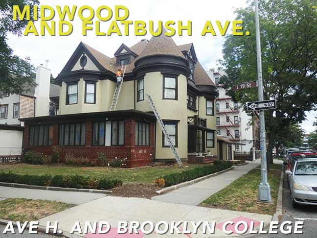

EVEN though I’m having a busy year with photography, having added over 4000 photos to my archive this year alone up to August, I’ve decided to use the most recent set from late August 2026 since I found the area compelling and also it was fresh in my mind since I hadn’t visited the area in nearly a decade if not longer. Beginning in the landmarked Fiske Terrace area in Brooklyn, I went past Brooklyn College and up Flatbush Avenue, wrapping up at the Church Avenue BMT subway. As I see it I have plenty of time to address earlier shoots! Since I got 129 photos, this record of my walk will again be split into two parts.
GOOGLE MAP: MIDWOOD TO FLATBUSH
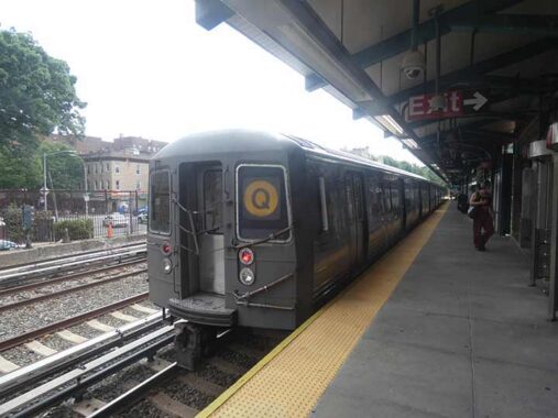
Today’s photos were taken on a somewhat hazy day, so there will be a bit of fuzziness. I’m always happy to get an R-46 on the Q train running on the Brighton line because of its window-facing seats in yellow and orange. These cars were introduced into service in 1975. New R-211 cars have been popping up on the B and Q lines, adding to the ones already in service on the A, C and G lines.
The Brighton line is interesting since it runs in a tunnel beneath Flatbush Avenue, an open cut south of Prospect Park, on an embankment south of Glenwood Road, and elevated from Neptune Avenue to its Coney Island terminal. In southern Brooklyn, it is bridged on iron trestles over main routes. The Brighton line is a remnant of a steam railroad founded in 1877 called the Brooklyn, Flatbush and Coney Island Railway. I have a more complete story on FNY’s Franklin Shuttle page. After it was acquired by Brooklyn Rapid Transit, the line was electrified and rebuilt in its current configuration, with all grade crossings eliminated; some photos from that process can be seen on FNY’s Magaw Lane page.
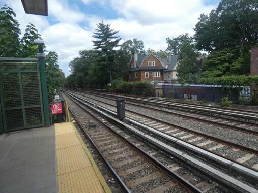
The B express and Q local’s run through Midwood supplies the aspect of “real railroading” as its near-grade height allows passengers to glimpse the private homes along the line, especially in landmarked areas such as Fiske Terrace. Even the Dyre Avenue shuttle in the Bronx or Staten Island Railway don’t provide many views such as this one.


Exiting at the Brighton’s Avenue H station. The southbound platform did not have a brick stationhouse until the early 2010s, when a brand new one was constructed featuring a Metrocard machine (now replaced by OMNY fare tap system) but not a token booth, one of the first new station houses without one. There’s a little open space that permits a view of the Avenue H businesses alongside the station.
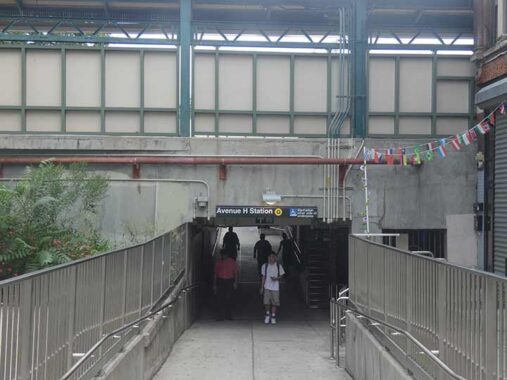
Avenue H doesn’t cross the subway as it’s still pretty much at grade here. However, there has been a pedestrian underpass here for many years. When I bicycled through the region on multiple trips between 1974 and when I moved to Queens in 1993, I took full advantage of the ramp, while being careful to avoid pedestrians. This is a courtesy not often afforded by present-day users of e-bikes and motor scooters.
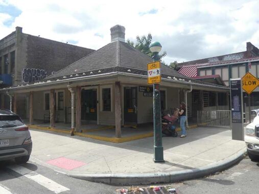


If you have been reading Forgotten NY for any length of time, you understand my fascination with the wood stationhouse for the northbound Avenue H station since its transformation to electrificed rail in 1907. It’s actually a former real estate office.
In his excellent article about the stationhouse, my ex-web host, Paul Matus, quotes the LPC’s Eve Kahn:
“The Avenue H station on the BMT line […] is the city’s only shingled wooden cottage turned transit station house. Often compared to a country train stop, it originally served as a real estate sales office for developer Thomas Benton Ackerson to sell property in the adjacent neighborhood of Fiske Terrace, an early twentieth century example of planned suburban development. The structure, with a hipped and flared roof and wraparound porch, evokes in miniature the area’s Colonial Revival and Queen Anne houses. After nearly a century of commuter traffic, the Avenue H station remains in service and retains much historic fabric, from a corbelled chimney to peeled log porch columns. It is one of a very small number of wood-frame station houses surviving in the modern subway system, the only station adapted from a structure built for another function, and the only surviving station from Brooklyn’s once-extensive network of surface train lines, which had originally attracted Ackerson and numerous other developers to the area.”
I’ve got plenty more photos and extra information on this FNY page, shot in somewhat clearer weather.
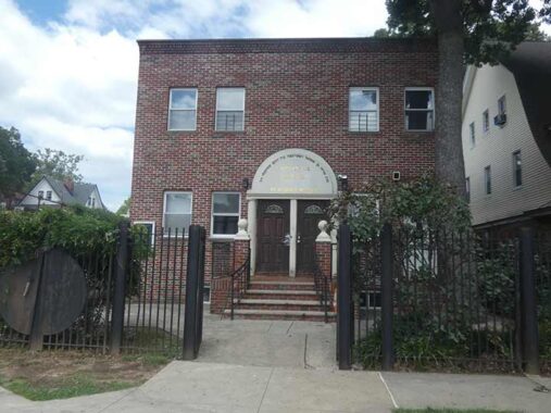
The Flatbush Minyan is a Jewish house of prayer on Avenue H just east of the subway. In Conservative, Reform, and other egalitarian movements, Jewish adults of either sex count toward the quorum.
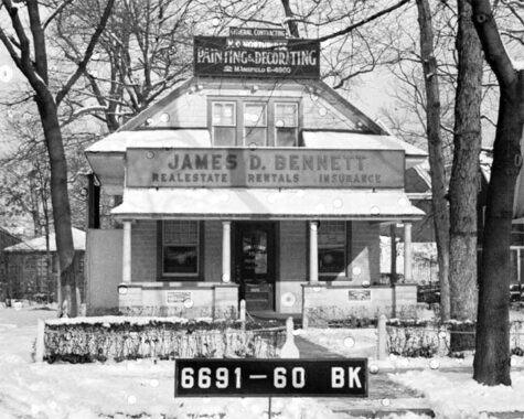
The building is relatively new. In another small building that survived into the 1980s, in 1940 it was the James Bennett real estate office—directly across the street from the former Ackerman office.
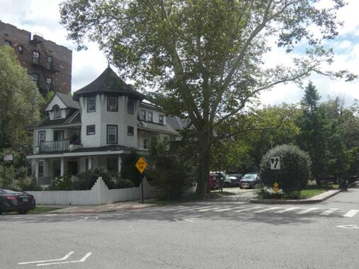
Southeast corner of Avenue H and East 17th Street.
In 1905, T. B. Ackerson Company purchased a densely wooded tract of land and immediately cleared it, laid out streets and installed underground water, sewer, gas and electric lines. Eighteen months later, the former estate belonging to oil merchant George P. Fiske had been transformed by some 150 custom-built, detached, three-story suburban houses with heavy oak ornamental mantels, staircases, beamed ceilings and built-in bookcases, ornately bordered parquet floors and elaborate cabinetry. A landscaped median and hundreds of street trees planted at the time of development continue to contribute to the idyllic feeling of the neighborhood. Historic Districts Council
Fiske Terrace came to encompass almost the entire area bounded by Glenwood Road (then known as Avenue G) on the north, the old LIRR Bay Ridge Branch tracks just south of Avenue H on the south, the Brighton Beach Railroad on the west, and Ocean Avenue on the east.
In a situation that is somewhat mysterious to me the dead-end stubs of streets south of Avenue H and abutting the LIRR/NY Atlantic Bay Ridge Branch (which is slated for a passenger light rail line to be built who knows when) remain unlandmarked, despite their quality; that means the handsome building here with the hexagonal corner turret can be victim to the predations of developers.
Avenue H serves as the south end of the Fiske Terrace/Midwood Park landmarked district. In September 2014, Forgotten NY Tour #84 swung through. As with most of the newer LPC reports, it gives a thorough historical description of the neighborhood and describes its architectural philosophies.
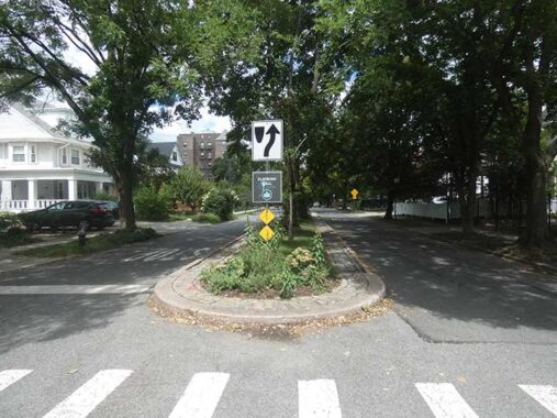
East 17th Street, which features some of Fiske Terrace’s more impressive houses, was afforded a center median like some of the area’s east-west streets like Glenwood Road. I didn’t enter the various districts south of Prospect Park on this walk, but these streets contain some of Brooklyn’s most impressive architecture from an era when appearances mattered for buildings, interiors and exteriors alike. These FNY pages recap some of the area.
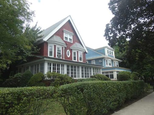
I’m an enthusiast of porches…both interior as with #829-831 East 18th Street at Avenue H and exterior. This Colonial Revival building was commissioned by developer T.B. Ackerson and helmed by architect Benjamin Driesler in 1906. There’s always something interesting to goggle at in these early 20th century buildings such as these window bays, oval window and attic beneath the peaked roof. A well kept hedge completes the look.
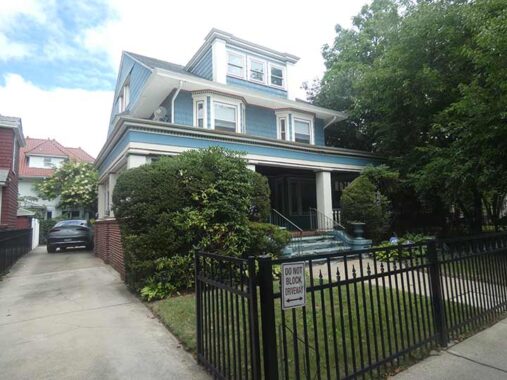
And #1809 Avenue H is even better. What was I thinking, shooting from this angle? The shrub is hiding the porch. Oh, well. It was also developed by Ackerson in 1906, with A. White Pierce the architect. It’s also a bay windowed Colonial Revival in white and robins egg blue. The cost of construction that year? A cool $6,000, which was real money back then. There were a couple of alterations in 1939 and 1988 but it looks largely the same as when built, with the exception that some of the original indoor porch has been opened up.
When I see well constructed homes, by osmosis I have a sense of pride about my own place, in Westmoreland Gardens in Little Neck. I am in the midst of a gradual window replacement project the last couple of years. When I moved in 20 years ago the window sashes were in poor shape and many were since damaged.


#822 East 19th has a wide lawn on its south side that faces Avenue H, and is well protected by an iron fence. The large Tudor Revival was built in 1909 by architects Slee and Bryson.
On FNY pages and tours, I generally don’t quote verbatim from Landmarks Preservation Commission reports…
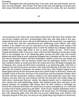
… and so on. They can go on ad infinitum in very thick architecturese. I do envy writers like Francis Morrone (who I admire greatly and reviewed Forgotten NY the Book in the New York Sun), who can instantly recognize all these terms, but everyone would nod off if I went on and on using the lingo!
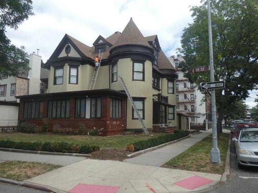
The corner-turreted #1901 Avenue H was under renovation when i passed. It is among the newer landmarked buildings in Fiske Terrace, having been completed in 1922. Landmarks could not find an original owner or architect, and classifies it as Medieval Revival, but its varied treatments on turrets and pediments also point to a Queen Anne influence. The organization also believes it could have been built on nearby Ocean Avenue and moved here at an earlier date than 1922. Most of Ocean Avenue’s original homes were moved or demolished in the 1920s to make way for massive apartment houses.
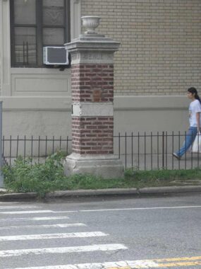
Brick pillars that may or may not be inscribed with names of cross streets were often installed to mark various developed areas in the outer boroughs. In this case, the cross streets are Ocean Avenue and Avenue H, but a block north, one of the pillars has Glenwood Road’s old name, Avenue G. This indicates that the switch occurred early in the 20th century, but after the pillars were placed.
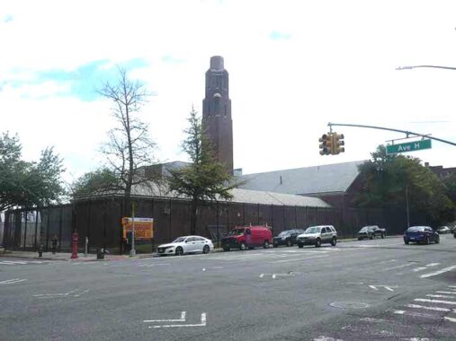
Brooklyn College was established in 1930 and its first completed structure was a heating plant (built to supply central steam heat and energy services to the campus) with a distinctive tapering brick smokestack, finished in 1936 under the auspices of the Public Works Administration (PWA), at the SE corner of Avenue H and Ocean Avenue.
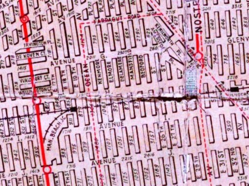
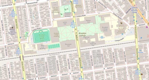
As we can see in the 1922 Hagstrom Brooklyn map excerpt, the construction of Brooklyn College campus in the 1930s necessitated a major change in the street grid. Originally Avenue H was mapped continuously between Ocean and Flatbush Avenues, while today it’s interrupted by the campus with two “Campus Roads” skirting the campus on the north and south. Only the northern section of Campus Road is open to public traffic. (Also note: Glenwood Road was still mapped as Avenue G in 1922).
Despite the “fleshed out” 1922 map not many residents had to be displaced for the campus, as it was an empty field in 1930 that had been used as a golf course and even as a staging area for elephants employed by the Barnum and Bailey Circus.
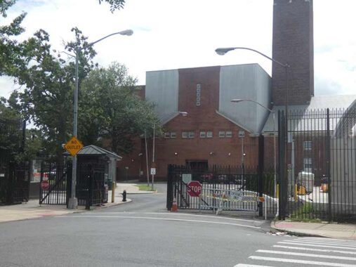
This is a closed-off section of Campus Road, facing the heating plant, which skirts the south end of the campus north of the NY & Atlantic RR. I noticed these particular lamp stanchions when bicycling through the area in the 1970s, and they sport the same mercury fixtures they did then; I’m attempting to ascertain the particular variety. This section of Campus Road no longer runs continuously.
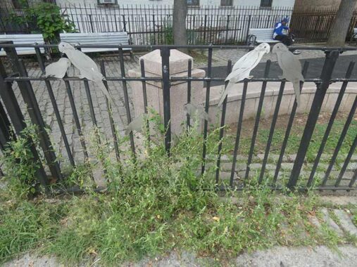
What’s called the Hot Spot Tot Lot, a kiddie playground, can be found on the curve of Campus Road just east of Ocean Avenue. What attracted me were the depictions of parrots on the fence, an apparent tribute to nearby quaker parrot nests atop the lighting stanchions beside Brooklyn College’s athletic fields. The story goes that parrots have nested in the Brooklyn Collge vicinity since the end of the 1960s. Either a couple of pet birds got loose, or a shipment of parrots from Argentina (where they are native) got lost.
In any case, the parrots have adapted brilliantly and pretty much behave just as your normal starlings, sparrows and pigeons have. After all, those birds were also at one time imported from other countries. On this particulat walk, I didn’t catch sight of the parrots or hear any of their high pitched squawks.
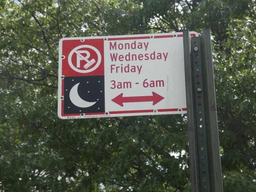
In this part of town, the street sweeper comes by between 3 and 6 in the morning. Pretty odd time given most aren’t up that time of the morning to move their cars; they probably do it by bedtime, say, 11 or 12, meaning the streets are probably missing parked cars by then. Why not sweep then?
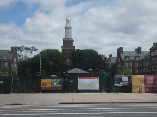
Bedford Avenue neatly bisects the Brooklyn College campus in two. A part of the City University of New York since 1961, the school, which boasts its very own campus green, the Quadrangle (which amazed me when I visited as a Brooklynite) was organized in 1930 in downtown Brooklyn and moved into its present campus in the late 1930s. The large white gilded dome tops the campus library. Among famed graduates are Congresswoman Shirley Chisholm, film director Paul Mazursky, attorney/columnist Alan Dershowitz, Brooklyn Borough President Marty Markowitz and television’s Jimmy Smits.
In the 70s and 80s, I could enter and cycle the Quadrangle, bold as brass, but since then security measures have been implemented and I saw people showing passes to personnel in guard booths. In the summer of 2026 the Quadrangle was being completely renovated and entry was impossible, in any case, and the Green Wall of Doom blocked it. I got a somewhat better photo when I passed while surveying Bedford Avenue in 2007; today, the sun angle was my enemy.
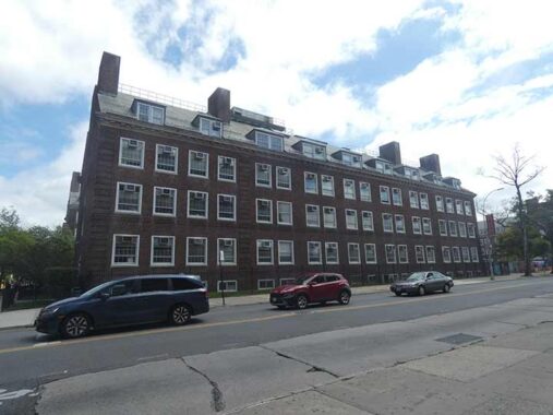
When I passed Boylan Hall in 2007, named for the first president of the college, it was covered by ivy which has since been excised. The neo-Georgian building was designed by architect Randolph Evans and opened in 1936.
Today, the campus is expanding, with new buildings by Rafael Viñoly, among others, buildings that include a new performance center, a new physical education center, and new classrooms. Randolph Evans never got another commission as important as this, and never designed anything else as large. He designed a couple of hospitals, and a town hall in Long Island, and was active in the AIA. He went back to designing suburban cottages and ranch houses, and was one of the architects chosen to design a series of kit houses for the Sears Roebuck Company in the 1940’s. He had a long and successful career, and died in 1974, at the age of 73. Brooklyn College was his masterpiece, and a fine one, at that. [Suzanne Spellen in Brownstoner]


Midwood High School is one of those “monumental” high schools I have gotten interested in of late, having recently checked out Fort Hamilton High in Bay Ridge. It’s connected to the newer Midwood Science Building by a handsome glass fronted pedestrian bridge, which so far has survived any attempts by the local miscreants to shatter it. The Ionic-columned neo-Classical (with a Georgian cuploa) older building was constructed in 1940-1941 and designed by Eric Kebbon, Superintendent of School Buildings, Design, and Construction for the New York City Board of Education.
Woody Allen, who was Allen Konigsberg in high school, piano tickler Marvin Hamlisch, and child star Emmanuel Lewis graduated from Midwood High, as well as former New York City Comptroller William Thompson. Scenes from the Jeff Daniels-Laura Linney film “The Squid and the Whale” were filmed here and the popular SING! New York City high school theater program also originated here.
Bedford Avenue and Campus Road is one of the few NYC intersections I’ve seen that rates a lamppost on all four corners, though the one on the NW corner needs its Bell fixture replaced.
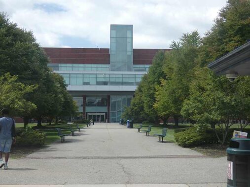
Looking west from Bedford avenue toward the West Quad Building, one of the campus’s newer structures. It was designed by Rafael Viñoly Architects (which have also had a hand in the Brooklyn Children’s Museum) and opened in late 2009. It was well guarded, so I remained on Bedford and zoomed the lens.
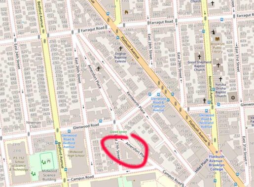


Heading north on East 27th on the way to Flatbush Avenue, I was attracted to the multifamily building at #723 East 27th, which according to a number of real estate sites was built in 1929, which seems about right. As I say here often, “they don’t build them like this anymore, kids.” What I didn’t know until I got to Amersfort Place is that it was constructed with a wedge shape to fit the unusual angle of the intersection. There is a pair of streets, amersfort and Kenilworth Places, that defy the grid, “forcing” Glenwood road to turn northeast.
I enjoy cutoff road remnants once part of an adjoining road, don’t you? (Don’t answer that.) As it turns out Amersfort Place was once part of the colonial-era Old Flatbush Road (which may have previously been an Indian trail). As it was straightened, for the most part, and became Flatbush Avenue, Brooklyn’s most famed corridor that cuts across the borough and connects the Manhattan and Gil Hodges (Marine Parkway) Bridges.
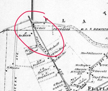
The section of Old Flatbush Road that became Amersfort Place (named for a city in Holland) had preexisting properties whose owners couldn’t be brought out so their section of the old road remained, while Flatbush Avenue was constructed to the east. Thi situation is illustrated on this 1873 area map. This area was actually in the town of Flatlands, just south of its border with the town of Flatbush. Both later joined the city of Brooklyn, and in 1898, Greater New York.
The complete Amersfort Place story is on this Forgotten NY page.


A sampler of Amersfort Place homes between Farragut and Glenwood Roads, including the corner turreted number on Glenwood. This section is not in a Landmarked area, so developers can plunder at will.


The Kenilworth Baptist Church occupies a simple pitched-roof, steepled church building in the triangle formed by Amersfort and Kenilworth Places. The church was founded in 1913 and has occupied this building since 1938.
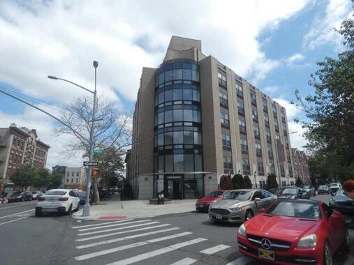
Kenilworth Place was mapped after Amersfort Place but parallels it from Farragut Road to Hillel Place. #1 Kenilworth looks new, but has served as a dormitory for Brooklyn College students and ran into some controversy as it was proposed to host a homeless shelter.


A sampler of buildings on Farragut Road between Amersfort Place and Flatbush Avenue: the massive #2601 “Brooksonia Hall”; the modern #2615, constructed in 2024; and the modest #2628, whose door and windows and angled to face the sunset much of the year.


Flatbush Avenue meets Farragut Road at Rogers Avenue, which crates another angled building plot. Till 2020, the space was occupied by a modest low-rise brick building, but in 2020, #1407 Flatbush, which resembles a land cruise ship, was constructed. Streeteasy: “This building features 22 residences all featuring floor to ceiling windows, luxury renovations and best of all, private outdoor space! The communal amenities include: a secured bike room, laundry in building, a large beautiful lobby and 2 restaurants on the ground floor of the building”
Next: up Flatbush Avenue
Check out the ForgottenBook (HarperCollins, 2006), as well as Forgotten Queens (Arcadia, 2013). I also have a chapter in the anthology “New York Calling: From Blackout to Bloomberg” (Reaktion, 2007). As always, “comment…as you see fit.” I earn a small payment when you click on any ad on the site.
8/30/26
2 comments
Evidence of the Manhattan Beach RR diverting from the Bay Ridge branch (old Hagstrom map) can still be seen today via Google Satellite View!
While buildings are likely to be locked anywhere, restricting access to college campuses seems to be largely a New York conceit.