
Little did I know that my February 2020 foray into the mid-Bronx (Morris Park, Allerton, and Williamsbridge) would be my final Bronx walk for what appears will be at least a few months if not a year. I depend on commuter trains, subways and less frequently, buses to get where I’m going, and shortly after this march the country sank into the Covid crisis and the city proceeded to become less safe. The latter will probably hinder me less than other people (I bicycled all over Brooklyn in the 1970s, remember) but despite assurances of cleanliness, I still won’t take the subway until there is a vaccine or the virus fades to obscurity. (Work considerations, should they arise, may cause me to amend my thinking, but reluctantly.)
It was a cloudy yet fairly mild day, as the winter of 2019-2020 was a mild one as far as NYC winters go, and I was as yet unencumbered by a face mask, though I constantly dabbed tears from my eyes, not from sorrow but from seasonal sensitivity.
GOOGLE MAP: WILLIAMSBRIDGE WALK
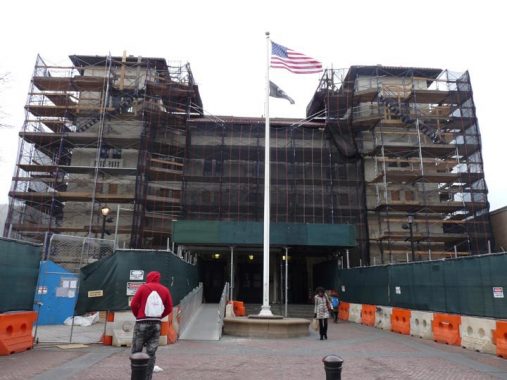
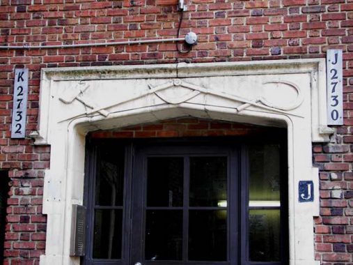
I took the #2 train to East 180th Street, where there’s a magnificent station house under all the scaffolding.
This station house is the largest in the New York City subway system. It was renovated and painted in 2012, and houses the station entrance turnstiles as well as some offices. It was formerly a police precinct house. Unfortunately on a previous visit I noticed that the paint was peeling badly and presumably here, it’s getting a somewhat better grade of paint covering.
The elevated platforms of the old New York Westchester & Boston passenger line (1912-1937) are still standing here. Until a track connection was made in the 1950s, a paper transfer was used to cross from the White Plains Line to these tracks. The NYW&B was a commuter line from the south Bronx to Westchester (eventually its builders hoped to get it as far as Boston) that went defunct in 1937 and was then annexed to the NYC subway in 1940.
The station house bears the image of the NYW&B’s standard-bearer, the Roman messenger god Mercury, with his winged cap and symbol of a staff entwined with two snakes (see below).
Here’s what it looks like without the scaffolding…


In 2012, I walked the entire NYW&B (at least the streets next to it).
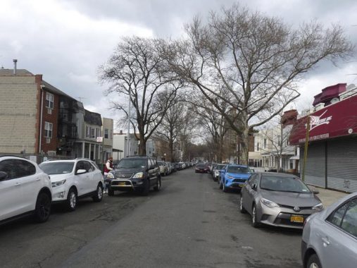
I headed up Morris Park Avenue, a street and a neighborhood I’ve covered adequately in FNY over the years.
I turned left on the unprepossessing Barnes Avenue which is actually one of the longest streets in the Bronx, beginning in Morris Park and running in fits and starts all the way to the city line at Mount Vernon, and even trickles into that city for half a block. Parts of it are actually an ancient colonial road.


I was seeking out this curious dead end on Barnes between Morris Park and Rhinelander Avenues called Barnett Place. The mapmakers (except for Open Street Map and Google) have all forgotten about Barnett Place, which is a dead end on Barnes Avenue just north of Morris Park Avenue. Barnett, a tidy cul de sac, boasts two trim brownstones that face each other. The late Bronx historian John McNamara in History in Asphalt reports that Barnett Place was named for innkeeper William Barnett, who kept his inn in the 1740s! Apparently an aboriginal lane, Barnett once extended from White Plains Road to Matthews Avenue; only this small piece is left.
The tidy, well kept buildings are numbered #108 and #111 which indicates that Barnett Place was indeed longer at one time.
In the Borough of Apartments 1957 Bronxdale Avenue, between Barnes and Mathews, is indeed massive. Whenever I’m on Bronxdale Avenue I can’t help but note that until 1900-1910 or so, Bronxdale cut across a large swamp now home to the Parkchester complex and was known as Bear Swamp Road; I wish some of these old colorful names could have been kept.
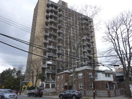
801 Neill Avenue is a 24-story high rise, one of the tallest apartment buildings in the Bronx (but still behind the Tracey Towers in Kingsbridge Heights).


At Brady Avenue and Mathews the NYW&B completely enshrouds the intersection. If you look closely you can see a relief of a caduceus: the emblem of the New York, Westchester and Boston RR was the Roman god Mercury and his caduceus, or rod with two entwined snakes. North of 180th Street and south of Pelham Parkway, the NYW&B is generous in allowing traffic to pass, located on a concrete embankment with iron bridges over the cross streets. At most of these intersections you can find 4 caducei in concrete.
It’s a commonly made mistake equating the caduceus with the medical profession. In medicine the symbol is the Rod of Asclepius, which has one entwined snake, not two.


I always like to show the unusual street lighting at this corner, which is almost completely covered by the railroad. One one corner we have an original curved-mast pole from the early 1950s, with a cobra neck attachment, and at the other corner is a pair of truncated masts. Each has had a number of lamp fixtures over the decades, starting out with Westinghouse AK-10 “cuplights,” then greenish-white mercury lamps, then bright yellow sodium lamps, and now bright white LEDs.


There was an additional attraction. Affixed to the pylons were a group of related artworks by what appeared to be the same person. There was nothing to identify them.


David Lydig went into business on Peck Slip in 1789 and owned a fleet of Hudson River sloops that delivered flour to his South Street wharf. Bakers were attracted to the block with a handy flour merchant nearby. Anticipating the completion of the Erie Canal, which would enable flour to be delivered from western farmlands at a cheaper rate, he sold his sloops at a profit and retired.
In the Morris Park section of the Bronx there’s a Lydig Avenue named for the family of merchants that included Philip and his son, David, who ran a mill in the West Farms section. David’s son Philip sold much of the property now home to Bronx Park.
More on the Seaport on this FNY page.
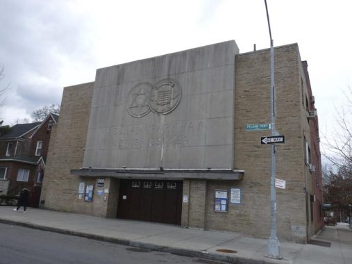
Pelham Parkway Jewish Center, Pelham Parkway and Muliner Avenue, a Moderne structure built in 1935.


The Bronx and Pelham Parkway (such is its official name) was constructed in the early 20th Century between Bronx and Pelham Bay Parks and bears close resemblance to Mosholu Parkway, i.e. a four-lane main road with access roadways flanking it. Unlike Mosholu, though, Pelham Parkway originally ran through open country; parcels for it were obtained from local landowners. Today’s map, with its grid of streets, looks quite different.
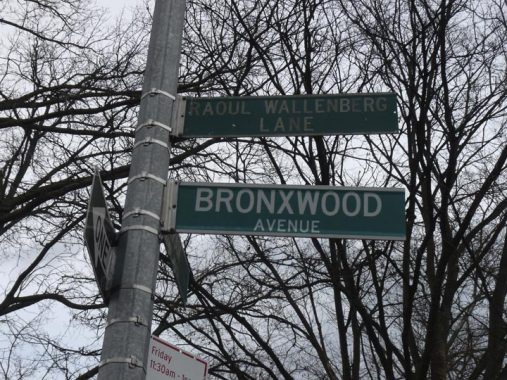
Historically the Pelham Parkway area has been heavily Jewish. Though only a gfew through streets cross Pelham Parkway (Bronxwood Avenue, Williamsbridge Road, Eastchester Road and Stillwell Avenue) numerous walkways cross it and two of them are named for individuals revered for saving Jewish lives: Lt. Colonel Yehonatan Netanyahu, a Bronx-born Israeli soldier who lost his life as commander of the squad rescuing passengers during the rescue of a hijacked plane at Entebbe, Uganda July 4, 1976; and Swedish-born Raoul Wallenberg, who saved tens of thousands from the Nazis by issuing protective passports and housing Jews in buildings in Swedish territory. Netanyahu’s brother, Binyamin, is the present [2020] prime minister of Israel.


The New York Institute for Special Education provides quality programs for children who are blind or visually disabled, emotionally and learning disabled and preschoolers who are developmentally delayed. It was originally known as The New York Institute For the Education of the Blind, founded in 1831. Its handsome campus buildings were designed by the firm of McKim, Mead and White, who also designed the original Penn Station.


The Roman Catholic Church of St. Lucy, and its parish school, the Lourdes Auditorium, are located at Bronxwood and Mace Avenues. The parish was established in 1927 and its handsome gray stone church building, modest by the standards of some other Catholic churches around town, was built the same year. Reflecting the ethnic makeup of the region, Masses are read in English, Spanish, Italian and Albanian.
Saint Lucy is an interesting figure in Church iconography. Lucy is usually depicted holding a chalice containing two eyes. Legend has it that the Roman emperor, Diocletian, put her eyes out in the torture that was visited upon Christians in the empire revered as the pinnacle of civilization at the time, but her sight was later miraculously restored before her death: she is patron saint for those with eye trouble. Her name comes from the Latin term for “light.”
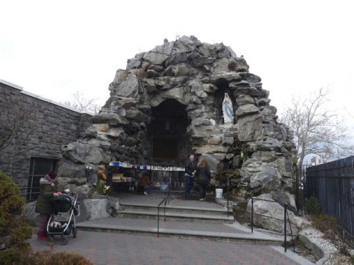


Associated with the parish is the truly impressive “Lourdes in America” grotto, which was considered important enough by Hagstrom mapmakers to be included in its print edition for decades.
The Bronx’s own Lourdes shrine was instituted by Msgr. Pasquale Lombardo, the founder of St. Lucy’s, in 1932, after he had visited the French shrine; inspired, he vowed to build a replica here in the Bronx. It was completed in 1939 and has become known as “Lourdes of America” over the decades, though shrines in Chimayo, NM and even the Exedra in Flushing Meadows-Corona Park in Queens, the site of the Vatican Pavilion in the 1964-65 World’s Fair, have laid claim to this title.
I have the complete story of the Bronx’s “Little Lourdes” on this FNY page.
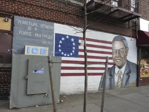
Four-star General Colin Powell (1937- ) is a son of the Bronx, though not of the northern Bronx, where this mural appears at Wallace and Allerton Avenues. Powell was born in Harlem and raised in the South Bronx. Unlike other Colins, he pronounces his name KOH-lin. A career soldier in the United States Army, he rose to National Security Advisor, Commander of the U.S. Army Forces Command and Chairman of the Joint Chiefs of Staff under the Ronald Reagan and George H.W. Bush administrations between 1987-1993. He was tapped by President George W. Bush to serve as US Secretary of State in 2001. He found himself at odds with the administration in 2004 and stepped down.
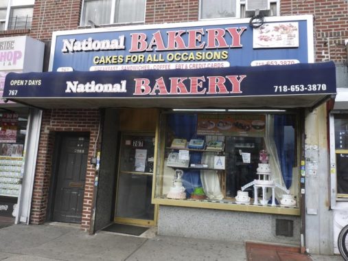


No doubt, there are a lot of bakeries across the USA calling themselves “National Bakery” but in the Bronx, the National Bakery is at #767 Allerton. At first, I thought the painted metal rolling gate on Wallace was the actual entrance.
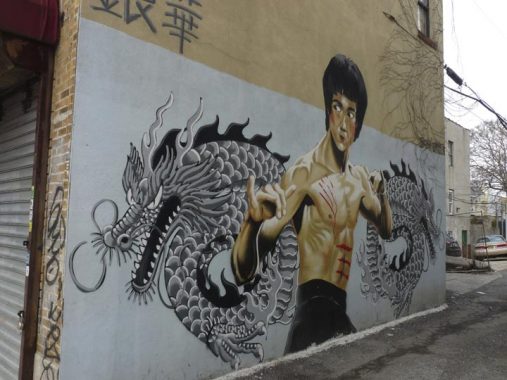
A mural depicting martial arts star Bruce Lee (1940-1973) with a Chinese dragon, referencing his biggest movie hit, Enter The Dragon, appears in an alley off Allerton between Holland and Wallace Avenues. He was born in San Francisco and raised in Hong Kong. He died at age 32 from what was officially described as a fatal reaction to a prescription painkiller.
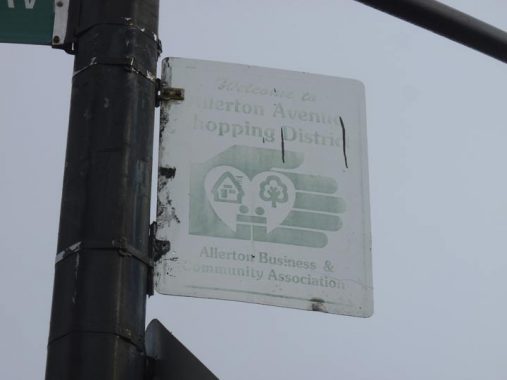
A faded sign for the Allerton Avenue Shopping District. It was produced with the now rarely-employed typefont Souvenir.


The hammer and sickle has long been used by the Communist Party as a symbol of the union of the workers (the hammer) and the proletariat, or the peasants (the sickle). It was introduced on the Soviet flag in 1922, replacing the earlier hammer and plough. Angola’s flag and Communist Parties in Britain, Israel, the USA and Guadeloupe use variants of the symbol, and Russia’s airline, Aeroflot, still does. As does a co-op in the Bronx….
The landmarked United Workers Cooperative Colony, Allerton Avenue and Bronx Park East in Bronxdale, were designed by the architects Springsteen and Goldhammer between 1927 and 1929. The buidings were sponsored by unionized Eastern European Jewish garment workers; the hammer and sickle chiseled elements above the doors can still be found in the development’s First House.
Oddly on today’s walk, I searched for the doorways with the hammer and sickle and couldn’t find them, so I used an image from a previous inspection back in 2007.
Holland Ave and Williamsbridge Road. The latter begins as a two-lane trickle, ambling here and there in Williamsbridge neighborhood before finding its oats at Boston Road, becoming a 4-lane truck route and roaring southeast to meet East Tremont Avenue at Westchester Square. The road, and the neighborhood, are named for a colonial-era toll bridge at today’s Gun Hill Road operated by John Williams. Holland Avenue is not named for the country but for NYC Mayor Edward Holland, who served from 1747 to his death in 1757.


Holland Avenue’s northern progress is stopped suddenly at South Oak Drive and you’re in the middle of some rambling, curving streets lined with interesting-looking private homes that, unfortunately, have been considerably altered over the years. We’re in the former enclave known as Bronxwood Park, which was developed by John Adee in the 1880s (an avenue in the area carries his name).


Bartholdi Street, which runs between White Plains Road and Bronxwood Avenue, was named for the sculptor of the Statue of Liberty, Frédéric Auguste Bartholdi (1834-1904). As you know, Liberty was a gift from France to the USA in 1886. Interestingly, though, both Bartholdi Street and the next street I’m going to talk about were named to honor a small French colony that sprung up in Bronxwood-Williamsbridge in the late 1800s.
Only peripherally is Magenta Street, a block north of Bartholdi Street, named for the bright violet color. Instead it was named for a French-Italian victory over the Austrians in 1859, led by Napoleon III at the Italian town of Magenta. Because both French and Italian immigrants resided in this Bronx enclave it was thought fitting to name the street Magenta in honor of a battle that led to the unification of Italy. The color itself was named for the town.
And now, as Paul Harvey would say, you know the rest of the story.
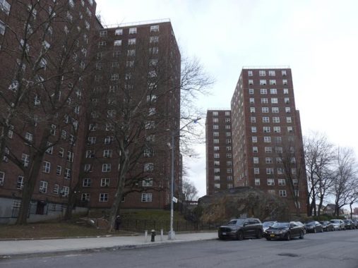
The Gun Hill Houses occupy a single block between Magenta Street, White Plains Road, East Gun Hill Road and Holland Avenue. The units were built in 1950 and consist of six 14-story buildings containing 733 apartment units.


Angry clouds set off the Church of the Immaculate Conception, East Gun Hill Road and Holland Avenue. The church was founded in 1902, with the original building on Briggs Avenue (today’s Tilden Street). The present Italianate – Neo-Romanesque brick twin-towered church was completed in 1925. It’s the second of two Churches of the Immaculate Conception in the Bronx: the first was founded in Melrose, at Melrose Avenue and East 150th Street, in 1853, with the present building there dedicated in 1889.
The Catholic concept of the Immaculate Conception was that Mary, Jesus’ mother, was conceived without original sin, with which the rest of humanity was saddled, stemming from Adam and Eve’s disobedience in the Garden of Eden. Baptism rids souls of original sin, according to Christian teaching.
Adjoining Wallace Avenue between Bartholdi Street and Gun Hill Road was renamed Capuchin Way in 1977 for the Capuchin Friars, the prelates who serve the parish. (It’s one of the few streets in New York City called a way.)
The Order arose in 1520 when Matteo da Bascio, an Observant Franciscan friar native to the Italian region of the Marches, said he had been inspired by God with the idea that the manner of life led by the friars of his day was not the one which their founder, St. Francis of Assisi, had envisaged. He sought to return to the primitive way of life of solitude and penance as practiced by the founder of their Order. wikipedia
The Order is named for the cappuccio, or hooded robe worn by members. For most people, monkeys come to mind when they hear the word “capuchin,” it’s likely that the monkeys, associated with street organ grinders, acquired the name because they resembled hooded monks.


The East End Funeral Home, 725 East Gun Hill Road, founded over 90 years ago by Victor H. Cinquemani, like most funeral homes is as tight-lipped as some churches regarding the history of their business and physical facility. Its parking lot, though, has some marvelously-rusted signage…
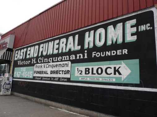
…and not only that it’s got an incredible old-skool green, black and white painted advertisement a half block away at White Plains Road.
It runs along a Native American trail and in 1900 went from Mosholu Parkway east only as far as White Plains Road. That road figured prominently in the Revolutionary War.
Gun Hill Road has been a major east-west artery since the colonial era and control over it was contested feverishly during the Revolutionary War. In January 1777, skirmishes occurred at Fort Washington, located then where Giles Place and Sedgwick Avenue would be, and then at John Williams’ bridge at Gun Hill Road and the Bronx River. The patriots took refuge at a redoubt (a small temporary fort made of earthworks, stone or brick) on January 25th, 1777, that was located just north of East 211th Street and west of Webster Avenue in what is now Woodlawn Cemetery.


It was Super Bowl™ Sunday and it was time to think about getting home. I reboarded the #2 train here at the Gun Hill Road station at White Plains Road. It’s one of the higher elevated stations in the Bronx and boasts views west toward Norwood and Van Cortlandt Park. The reason it is so high is that its second level once supported the north end of the Third Avenue El, which traveled here from lower Manhattan, mostly up 3rd/Third Avenue (as it is spelled in the Bronx) and then east on Gun Hill Road here to its terminal.
And that kicks it in the head for another Bronx adventure.
Check out the ForgottenBook, take a look at the gift shop, and as always, “comment…as you see fit.”
7/5/20
12 comments
If you’re okay with commuter trains as opposed to the subway you still can see a good deal of the Bronx. LIRR to Penn, short walk to Grand Central, and then Metro North.
Just one minor correction, please, to an excellent writeup. The #2 IRT trains occupy the second level of the elevated Gun Hill Road Station. Third Avenue el trains occupied the first (lower) level, until that line was closed in April 1973. The empty trackways remained there for many years afterward but all remnants of the Third Avenue level were removed about ten years ago.
Thanks! Needed a Shot of this Today!!!
Kevin, no mention of Yonatan Netanyahu’s younger brother? He’s the longest serving and as of this writing, the sitting Prime Minister of Israel…
“Netanyahu’s brother, Binyamin, is the present [2020] prime minister of Israel.”
…ghost editing to save face. It wasn’t there when I responded and not the first time that you’ve done that when someone pointed it out.
You didn’t have to give a smartass response, you do this a lot when it’s unnecessary. You goofed, no need to be snippy about it to save face.
Nope, I had Binyamin Netanyahu in there from the beginning. I don’t get snippy.
And Ed, the gotcha game is for grade schoolers.
Being Israeli-born, I already know that Benjamin Netanyahu is the current PM of Israel even though I don’t personally support him.
A funeral home with the word “End” in it. Perfect!
First, bravo on the proper use of “presently”.
Two, as always, a fantastic look at yet another unique perspective on NYC, from which I always end up learning something new. To wit, after completing even just the section mentioning Barnes Road, the usual subsequent heavy pinballing around on Google Maps led me to discover the strong Jamaican / Caribbean influence in the upper reaches of the Bronx. I look forward to the time when using the subways to visit such spots will be less of a risk, health-wise.
Keep up the great work.
Wow, this was well done. I’m worked as a public school teacher in the Bronx since 2003. I started at MS 135 on Wallace and Mace Ave. I worked at Columbus high school on Astor Avenue And currently at Evander Childs campus on gun Hill Road. I’ve spent many of free periods walking these very streets and seeing these very structures that were commented upon in this article. A wonderful vibrant neighborhood. It was interesting to see the Colin Powell mural on Wallace and Allerton used to be a 9/11 never Forget mural right in the same corner