

I set off from Sunnyside for a therapeutic walk on an October 2020 Sunday. The day began in bright sunshine, but low, dark clouds soon showed up, dark enough that I had to wield Photoshop to lighten up some of these images to make them at all visible. This year, October’s fall colors showed up relatively early, but most of the month, the weather has been quite murky and overcast; I dislike photography in cloudy weather (even though shadows between October and March can present problems of their own). I was in well-worn territory as I have been a Queens resident since 1993, but hopefully, I caught some things, or noticed some nuances, I hadn’t before.
GOOGLE MAP: SUNNYSIDE TO WOODSIDE
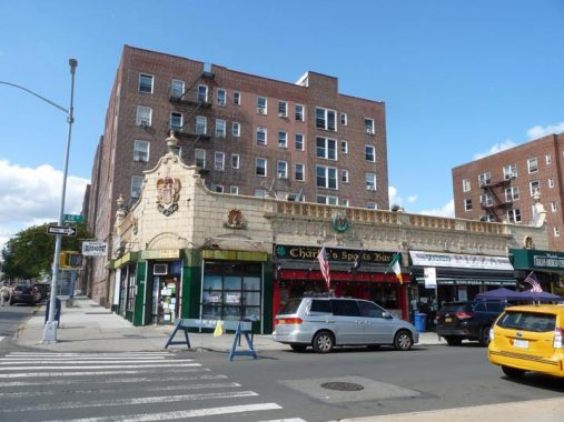
Once again I found myself by this classic terra cotta storefont at Queens Boulevard and 60th Street. There are dozens of similar ones all over town and I have been calling them former Child’s locations. It occurs that I do not have definitive proof that the terra cotta fronts, mostly in buff with green highlights, featuring sea horses, fish and other ocean-associated images are in fact Child’s locations. I have been inferring it from one that I knew was definitely a Child’s, on the Coney Island boardwalk at West 21st Street. I may very well be correct, but I’d like some corroborating evidence one way or the other to put this to bed for good. If you can help, shoot me an item in Comments.
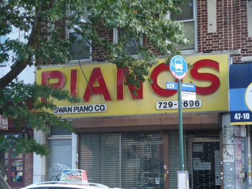
I’ve never actually seen Swan Piano, on Greenpoint Avenue between 47th and 48th, actually open, yet its vinyl and platic sign remains in place as it has for a couple of decades now.
I think FNY covered Greenpoint Avenue definitively previously, so I made my way quickly to Hunters Point Avenue…


St. Raphael’s Church, named for an archangel, dominates views from Hunters Point, Blissville, Calvary Cemetery, and Sunnyside. It was built in 1885 here at Greenpoint and Hunters Point Avenues and replaced an earlier structure; the parish dates to 1865. The reputed architect is Patrick Keely, the famed architect of mostly Catholic churches in the 19th Century.
As always, the most comprehensive history of this church, as well as others, is found on the American Guild of Organists’ NYC pages.
The parish of St. Raphael was established in 1865, and the first Mass was said in November 1868 by Rev. Theodore Goetz, who attended the parish from Winfield. At the time, the area was known as Blissville, named for Neziah Bliss, inventor, shipbuilder and industrialist, who owned most of the land in the 1830s and 1840s. Blissville was bordered by Calvary Cemetery to the east, Newtown Creek to the south, Dutch Kills (a tributary of Newtown Creek) to the west, and the Queens-Midtown Expressway to the north. Blissville existed as a small village until 1870 when it was incorporated with the villages of Astoria, Ravenswood, Hunters Point, Dutch Kills, Middletown, Sunnyside and Bowery Bay into Long Island City.
Located on Greenpoint Avenue at Borden Avenue, the first church was a wooden frame building that would serve as the mortuary chapel for Calvary Cemetery. The second pastor, Rev. N. J. Farrelly, who succeeded Father Goetz after his sudden death in 1879, was determined to build a new and larger church. In 1881, the old church was demolished to make room for the new, and Bishop Loughlin laid the cornerstone for the present church on June 18th that same year. However, due to a lack of funds only the stone basement was completed by Christmas. Over the next four years, sufficient funds were raised and the completed church was dedicated by Bishop Loughlin on June 7, 1885. Built of brick and sandstone, the church is 149 feet long, 69 feet wide, and the height of the steeple is 150 feet. It is believed that the Gothic-style church was designed by Patrick Keely.
On a sad note, St. Raphael’s elementary school was forced to close in June 2012 because of declining enrollment and rising costs.
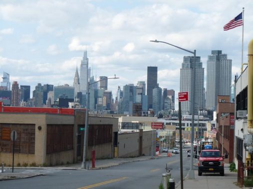
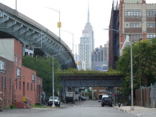
At 35th Street looking west, Hunters Point Avenue is on a slight elevation and the view of midtown Manhattan is outstanding. However, increasingly, it’s a view of Long Island City as towers in western Queens blot the view of Manhattan. Recent “supertall” apartment tower construction along 57th Street had dwarfed the Chrysler Building in the view. As little as forty years ago, the Chrysler, and the Empire State, would have easily been the tallest buildings in the picture. The tall black rectangle is the Trump International, once the tallest residential building in the world. At extreme left is the Hudson Yards tower with the highest observation deck in New York City.
Hunters Point Avenue extends east and southeast from 49th Avenue at Dutch Kills east and southeast to the Queens Midtown Expressway at 38th Street. Before the expressway was built, it ended at Borden Avenue. And prior to the Great Numbering of Queens streets in the 1920s, Hunters Point Avenue extended west as far as Jackson Avenue; the portion west of Dutch Kills was renamed 49th Avenue. However, the #7 subway station at 49th Avenue and 21st Street is still (rather confusingly) named Hunters Point avenue.
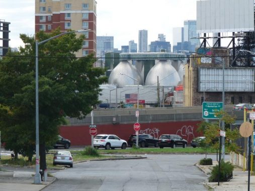
The Newtown Creek Wastewater Plant, a.k.a. “digester eggs” (some call them the Shit Tits), dominate views in Greenpoint and in Hunters Point, across Newtown Creek, seen here from Hunters Point Avenue and 34th Street. The plant actually has a visitors center, which has become one of Brooklyn’s top ticket attractions. The eggs, eight in number,34th Stre are lit purplish-blue at night.
The digesters […] process up to 1.5 million gallons of sludge everyday. Each egg, clad with low reflectivity stainless steel, is 145 feet high and 80 feet in diameter. The eight eggs were welded on site from pieces that were brought from Texas and fabricated by Chicago Bridge and Iron. It took three months to assemble each one. Although the weight for each egg is around 2 million pounds when empty; it is calculated that they may weigh up to 32 million pounds when processing sludge. The blue lights illuminating the eggs were designed by artist Hervé Descottes of L’Observatoire International, an American/French company. Hervé Descottes is known for lighting projects ranging from the diverse architecture of Steven Holl and Frank Gehry, to local projects such as Lincoln Center, the Highline, and Columbus Circle. The first four eggs came into service on May 23 [2008] and the rest will come online by the end of the year. NYC
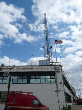
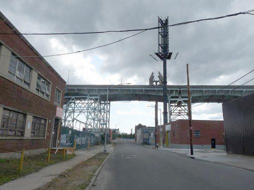
The FDNY maintains an incredibly tall antenna at Hunters Point Avenue and 34th Street. By far it is the tallest object in the neighborhood.
From Comments:
“…that radio tower is a repeater, which does just as it sounds: repeats voice traffic so there are no gaps in communications. They are scattered throughout the city, all large cities have them due to the need for coverage and redundancy especially as there can be a lot of radio traffic during fires and other nasty events.
“…that is one of the most important buildings to the FDNY. It’s home to their Buildings Unit, their EMS medical supply depot, and more importantly: their fleet maintenance complex. Every fire truck in the city goes there to be fixed, with the place taking up 80% of the block on three sides.”
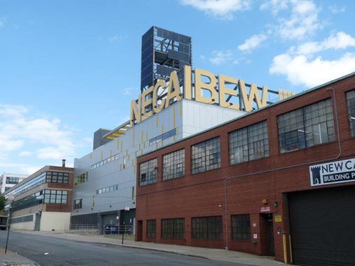
48-39 33rd Street off Hunters Point Avenue was remodeled in 2015 as the local headquarters of the NECA-IBEW Benefits Administration Association. The prominent letters stand for the National Electrical Contractors Association and the International Brotherhood of Electrical Workers.
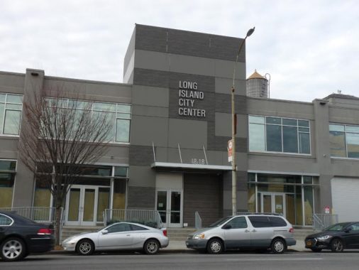
Long Island City Center, 48-18 Van Dam at Hunters Point Avenue, is in a remodeled building once home to the National Braid Manufacturing Corp. (as you can see here on Street View from 2015). it is now home to the Teamsters Local 813 and Local 27 IBT pension fund offices.
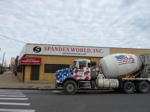
I thought Spandex went out with 1980s exercise videos, but it’s still widely used and Spandex World at Hunters Point Avenue and Van Dam Street is where you (or at least wholesalers) obtain it.
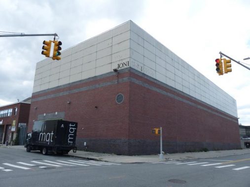
Sometimes, the purpose of buildings in industrial areas is hard to discern. This near-windowless monolith appears at Hunters Point Avenue and 31st Street, with only some lettering “IONI” in Goudy Bold on the corner as any sort of signal. A look back on various Street View pages indicates that a D is missing and the word at one time said “DIONI.” As a rule, secrets of this type aren’t given up easily. Finally, a look at Cylex.us.com reveals:
Home Furnishings, Furnishing Wholesale, Furnishing Manufacturers, Housewares, Houseware Manufacturers, Houseware Wholesale, Manufacturer, Printing Services, Print Retail, Pictures, Picture Frames, Frame
Thus, this is either a plant where such goods were produced or a warehouse where they were stored.
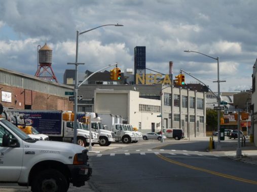
When Hunters Point Avenue was laid out over a century ago, builders made it curve southeast — gradually at first — at 31st Street, originally toward Borden Avenue which was then the northern border of Calvary Cemetery. “All roads lead to Calvary” says Mitch Waxman in the Newtown Pentacle, the virtual online Bible for this part of town.
Here it is pictured making the turn, with the massive NECA-IBEW sign in evidence, which is not a coincidence.


Hunters Point (which should really have an apostrophe in Hunter’s) is one of the places that the Department of Transportation hasn’t been stringent about correct street signs. Looking north on 31st Street we see the building now called The Factory, one of the massive industrial factrories, warehouses or lofts that were built in the area south of the Sunnyside Yards after the Yards were constructed from 1900-1910. The Factory was originally a Macy’s furniture warehouse; now it is a “workspace” where many different companies place their computer terminals and desks. Many people are employed in these places now; I worked in the very one shown here, simply called Spaces, at 1740 Broadway near Columbus Circle. Probably the best-known example is WeWork.


Scattered throughout NYC, and no doubt many industrial towns, are giant neon signs bearing the names of now-extinct businesses. Urban explorers can seek out and research these signs in a similar manner to biologists looking for dinosaur bones or anthropologists seeking the remains of Piltdown Man.
The Thypin Steel Company was founded in 1910 and became one of the largest steel companies in the Northeast, with an annual revenue of $335 million. It was sold to Ryerson Tull, a Chicago steel company, in 1997. Its name lives on in the Thypin Oltchick Institute for Women’s Entrepreneurship. Gertrude Thypin Oltchick (1916-2012), the daughter of the founder, ran the company for many years.
O Brother, Where “R” Thou? Other Neon Billboards


The Hunters Point Avenue Bridge, which crosses Dutch Kills, opened in 1910, is a vehicular bascule bridge that replaced two earlier bridges, made of wood and then iron. It is two years younger than the neighboring Borden Avenue Bridge, which is one of four retractile bridges remaining in the USA. It celebrated its centennial in 2010, though it had been largely renovated in the 1980s.
Seldom commented on, the Hunters Point Avenue Bridge segments Dutch Kills neatly, and has done so for [over] a century now. The marshes and streams which once typified the area before the advance of railroad and vast agglutination of industrial installation are long gone, relegated to subterranean sewers and masonry clad spillways, but a century ago the Hunters Point Avenue Bridge (and its predecessors) allowed egress between the terrestrial isolation of the Long Island City center and the rest of western Queens. Newtown Pentacle


In the precolonial and immediate postcolonial era, Newtown Creek was an inlet of the East River extending east and southeast into western Long Island, and had multiple branches and rivulets that spread out through marshy territory for perhaps a few miles surrounding the bulk of the creek itself. After the Industrial Revolution those rivulets and watery capillaries were tamed and placed underground into sewers. A number of them, like Newtown Creek itself, were tamed into canals by surrounding them with reinforced bulkheads. Perhaps the most prominent of these are English Kills and Dutch Kills; according to legend, Dutch Kills extended north into what is now Astoria, mainly held by the Dutch in the 1600s, while English Kills headed west into what became East Williamsburg, dominated by the British, though elements of both groups occupied land north and south of the Creek.
Here we see Dutch Kills looking north toward a turning basin at 47th Avenue and south where the massive Queens Midtown Expressway is bridged over it.
The first settlement in western Queens, in 1642, may have been Richard Bruntall who owned 100 acres on the east side of Dutch Kills at its intersection with Newtown Creek. The farm included all of Blissville one half of Old Calvary Cemetery. Ten years later he sold the western end to the Debevoise family whose homes remained on Van Dam Street in 1900. The eastern end of the farm was sold to William Herrick of Flushing who died a few years later.His widow married Thomas Wandell. He died in 1691 after expanding the farm to include all of Cavalry Cemetery and Laurel Hill. His nephew, Richard Alsop inherited the farm. The colonial Alsop family burial ground can still be seen among Cavalry’s modern graves. The Alsop Farm, which grew tobacco, was on the richest land in Newtown Township. With the intrusion of industry in the 1840s on Newtown Creek, it was sold forming the nucleus for Cavalry Cemetery. Greater Astoria Historical Society
With the passage of time, some names have been replaced. The present Dutch Kills neighborhood is north of the Sunnyside RR yards, and doesn’t border on the namesake creek at all.
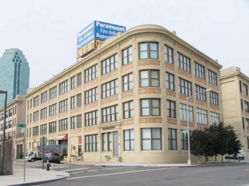
Back in 2010 I was rather rhapsodic about this handsome building, just north of Hunters Point Avenue at 27th Street:
“I don’t know the original purpose of this handsome structure on 27th Street and Pearson Place, but it’s the present home of Paramount Fine Antique Reproductions. Looks like it’s recently been renovated top to bottom.”
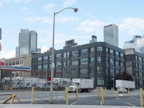
Good gravy, see the way it looks in 2020. Renovated top to bottom again but this time clad in gun metal gray, with all the extra ornamentation removed.
Update, 11/5/20: See Comments for a history of this building.
A look south on 27th Street at 50th Street toward the Queens Midtown Expressway. It looks desolate here but we’re actually quite close to New York City and even closer to Hunters Point proper, which has had one of NYC’s biggest building booms over the past decade, with hundreds of new apartments; a new park overlooking the East River; a new public school and a new library. Here, though, things look about the same as they have since 1940, when the QME opened.
I am drifting into Old Man Argues With Cloud territory, but the new construction at the Queens East River frontage has compromised views of the King of All Buildings, at least from some vantage points such as west on 50th Avenue from 27th Street. The QME is seen at left while disused LIRR tracks that connect Sunnyside Yards with the now-dismantled Degnon tracks along 47th Avenue and other industrial Sunnyside streets are in the foreground.
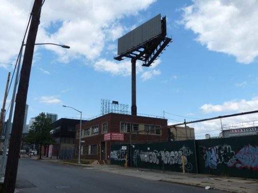
Advertisers are simply not spending whatsoever on exterior ads during the Covid crisis. You notice this at commuter railroad stations where ads over year old promoting TV shows that have come and gone, as well as Broadway shows that won’t reopen for months (if they don’t close) can be seen. The massive stanchions with billboards meant to catch the attention of motorists traveling on the Queens Midtown Expressway are mostly bare in late 2020, with the exception of an occasional public service ad.


No one, except perhaps Waxman in the Newtown Pentacle, writes much about the extraordinary infrastructural elements to be seen in Hunters Point. The Western leg of the Queens Midtown Expressway (I-495) opened in 1940 when the Queens Midtown Tunnel was. From a tunnel deep beneath the East River, just past the Queens-side EZ Pass plaza, the expressway rises to an incredible height as it crosses Dutch Kills, apparently to allow tall masted ships to progress there. It then travels at grade or on very occasional elevated sections to eastern Queens in sections built in the mid-1950s.
A nomenclature quirk: Officially, I-495 is not signed as the Long Island Expressway until it escapes Queens at the Nassau County line. From the tunnel to Queens Boulevard, it’s the Queens Midtown expressway (with Borden Avenue serving as a service road on its north side east to Grand Avenue) and east of Queens Boulevard, it’s the Horace Harding Expressway, named for a Robert Moses crony.
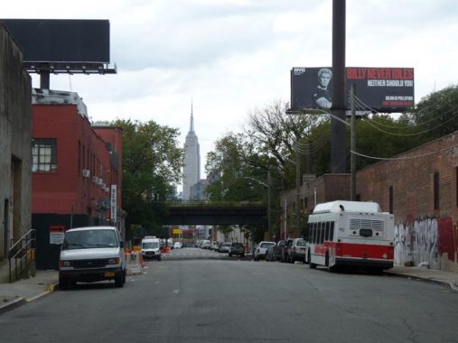
Now that’s more like it: the view west down 51st Avenue. On the public service billboard is pictured Billy Idol, a 1970s punk who became a 1980s pop musician (“White Wedding,” “Eyes Without a Face”) who appeared in ads urging motorists to not “idle” their engines. Idol, idle, get it?
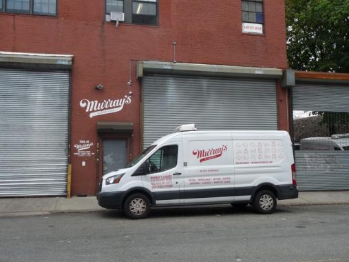
I was surprised to find a Murray’s Cheese distributorship on 51st Avenue. There are some retail locations in Manhattan, notably on Bleecker Street.
Murray’s Cheese Shop was opened by Spanish Civil War veteran Murray Greenberg in 1940.
It’s the type of place New Yorkers brag about – a real institution, a place serieux where the ownership and management is obviously obsessed with what they do and have a tremendous drive to be the best. In a city as large as New York, these specialized niche retailers can really thrive. Murray’s was founded in 1940 by Murray Greenberg, starting as a wholesaler of butter and eggs. Rob Kaufelt, the current owner, bought the business from Louis Tudda in 1991. In 2004, they moved from a much smaller cramped location across the street to their current space, where they purchased the building. They lease adjoining retail spaces to other high quality food retailers, (Amy’s Bread and Wild Edibles.) Murray’s retails over 250 varieties of cheese and wholesales to 75 restaurants, including many of the city’s finest. I was fascinated to learn of their authentic underground cheese caves where affinage (the art of aging) is practiced (Murray’s was one of the first cheese retailers in the U.S. to do this) – French affineur Herve Mons was consulted in their construction. Kaufelt travels the world to acquire cheese and has forged relationships with many artisanal cheese makers and is able to introduce these special cheeses to their American customers. NY Daily Photo


The many-windowed Blanchard Building, its U changed to a V by stonecarvers under orders to make the “U” the Roman “V” to impart majesty and permanency, stands sentinel on Borden Avenue near 21st Street, the old Van Alst Avenue. Its upper floors look out on the noxious and noisome Newtown Creek. It’s one of the brick hulks around town that I ceaselessly admire, whether they are factories or warehouses (as almost all of them once were) or converted into residential apartments. In this part of Hunters Point, that fate is still largely unlikely, as the residential fever that has taken over the west side of the neighborhood near the East River hasn’t reached its business side. Borden Avenue is one of the handful of main streets allowed to keep its name after many were given numbers in the early 20th Century.
In a former life the Blanchard was a factory that made fireproof doors and shutters. Some years after a fire started in the Columbia Paper Bag company engulfed it in flames, Blanchard rebuilt, only to merge with the John Rapp Company, becoming the United States Metal Products Company.
Today the Blanchard hosts many businesses and offices; it’s been recently converted to apartments.
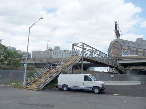
North of the QME, 21st Street picks up lanes and is one of Queens’ busiest north-south routes (its fromer name, Van Alst Avenue, is still on a G train station) it’s just a trickle between Borden and 51st Avenues. This rickety footbridge takes you over LIRR tracks (see below).


Though Borden Avenue is a relatively busy east-west route, it has a Long Island Rail Road grade crossing, controlled by signals and gates. several passenger trains en route from LIC to Jamaica do pass this way during mornings and evenings. I’m not sure how many freights use these tracks, barring hanging around for several hours during the week.
These tracks take Hunters Point station-bound trains from the LIC yard over busy Borden Avenue, which is the direct link for vehicular traffic from Hunters Point to the Long Island Expressway. This old road first appears on maps in the mid-to-late 1800s and is named for an early area landowner, not the dairy conglomerate. Few streets in Queens have undergone quite as much of a transformation as Borden Avenue; photos from the early 20th Century show it as a suburban stretch lined with small shops and foliage. In the 1950s, though, the Queens-Midtown Expressway was bruited along its length, utterly transforming it to a service road. Here in Hunters Point, though, Borden Avenue still maintains something resembling autonomy.
FNY reviewed all NYC grade crossings here.
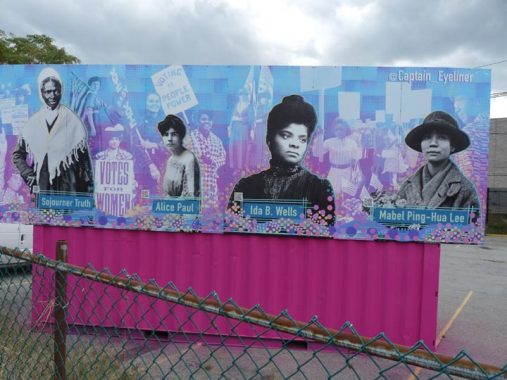
Here is one of a pair of billboards highlighting politically significant women at the LIRR yards at Bordern Avenue east of Vernon Boulevard. Sojourner Truth (1797-1883) was a Civil War-era abolitionist and temperance advocate; Alice Paul (1885-1977) a leading suffragist; Ida B. Wells (1862-1931) an advocacy journalist and editor; and Mabel Ping-Hua Lee (1896-1966) activist against the Chinese Exclusion Acxt prohibiting immigration from China in the early 20th Century.
Feeling drops of rain, it was time to get to the 7 train…
Check out the ForgottenBook, take a look at the gift shop, and as always, “comment…as you see fit.”
11/1/20
15 comments
As a former piano player for cash money who lived Greenpoint and 40. I am curious how that shop is still there.
“The Blanchard looks across the street at a Fresh Direct depot on Borden, …” Didn’t you hear that the vacated Fresh Direct depot was demolished and is currently a massive and busy construction site? I guess you didn’t notice because your route took you north of Borden Ave.
okay.
I guess I’m one of those who feel that the recent construction boom that Hunters Point and LIC got isn’t for the better. A lot of the new buildings that went look pretty banal and sterile if you asked me, but that’s just probably me saying that, so please don’t grill me on that statement. Just like some of the Brooklyn neighborhoods right across the East River, it came to no surprise that the ones in Queens would be next. The same may happen to some of The Bronx neighborhoods right across the Harlem River if not already. I used to remember when look at these neighborhoods from either FDR Drive or from the ESB when they looked distinctive, but that has all changed since then as well as when the same was for Greenpoint and Williamsburg. Of course those on certain message boards who always like the latest everything will say that it’s just progress when I feel as if this is making starting to feel like Everywheretown, USA, but again this is just me saying this.
Kevin, the FDNY facility is actually between 34th and 35th Streets. And that radio tower is a repeater, which does just as it sounds: repeats voice traffic so there are no gaps in communications. They are scattered throughout the city, all large cities have them due to the need for coverage and redundancy especially as there can be a lot of radio traffic during fires and other nasty events
You didn’t notice it, but that is one of the most important buildings to the FDNY. It’s home to their Buildings Unit, their EMS medical supply depot, and more importantly: their fleet maintenance complex. Every fire truck in the city goes there to be fixed, with the place taking up 80% of the block on three sides.
Thanks. Added to story.
The block used to be called “Red Square” for all the apparatus parked on the street, awaiting repairs.
Kevin- in case you wanted a detailed history of that rounded-cornered factory building on 27th St and Hunters Point Ave, here’s my research:
Marcus Ward Company
Built in 1917. 4 floors.
This stationery manufacturer and printing company was established in 1848 in Belfast, Ireland. Originally known as John Ward & Sons in the first half of the 19th Century, the company grew from a small paper mill into a successful color lithographer, specializing in Victorian-styled calendars and greeting cards towards the end of the 19th Century that garnered international reputation, moving to London by the end of the 1800s. At the turn of the 20th Century, as satellite branch was established just outside of Bush terminal on 29th St in Brooklyn, where Ward remained until completion of this site and the beginning of 1917. This site, housing the company’s main manufacturing plant and company headquarters, employed between 150 and 200 people in the first decades of early 20th Century, while maintaining permanent salesrooms at 200 5th Ave in Manhattan, as well as sites in Chicago, Philadelphia, and San Francisco. Several of Ward’s brands during the early 20th Century were marketed towards the higher classes, with brand names such as “Gentlemen’s Writing Paper” and “Gentlemen’s Stationery,” white paper made from both parchment and bond paper, as well as Irish linen and Irish poplin. Other brands included the “”Papeterie des Tuilieres,” rose, blue, and pink envelopes embossed with a gold-colored four-leaf clover. By the early 1940s, however, the nearby Henry Waldes Company, also known as the Waldes Koh-I-Noor Company and initially established on 27th St and Austell Pl, purchased the facility, as well as several other factories in the immediate area, owning this building until at least the late 1970s (see above building for a detailed history). During this time period, the building also housed Kelvinator Corporation, a national home appliance manufacturer specializing in refrigerators. Founded in Detroit in 1914 by engineer Nathaniel Wales, the company took its name from Lord Kelvin, the founder of the mathematical concept of Absolute Zero. Wales introduced the world’s first refrigerator with automatic controls in 1918, and within five years, his company controlled 80% of the home refrigeration market. In the mid-1930s, the company unveiled its Kelvin Home design, one of the earliest attempts at mass-produced residential air conditioning and heating. During World War II, the entirety of the company’s operations were converted to military production. After a series of corporate acquisitions in the latter half of the 20th Century, the Kelvinator name continues to grace products across the globe. Currently, a film archival company known as Paramount Antiques leases space inside the factory.
Here’s a bit more about the history of Route 495, aka Long Island Expressway. Going west to east, the initial stretch was built in 1940 between the then-new Midtown Tunnel and the Brooklyn-Queens Expressway, and was known as the Midtown Highway. That stretch includes the high and graceful viaduct described here. Horace Harding Boulevard initially began at Queens Boulevard (at today’s Queens Mall) and went east to Nassau County as NYS Route 25D. It was a wide arterial route, built in the 1930s, with service lanes flanking the central roadway, much like Queens Boulevard. In 1955 the gap between the BQE and Queens Boulevard was filled with the then-new Queens-Midtown Expressway. Between 1957 and 1960, Horace Harding Boulevard was rebuilt into today’s depressed expressway, with the service road flanking it for the entire route east of Flushing Meadow Park until the Nassau County Line.
So by 1960 there was a continuous expressway from the Midtown Tunnel to the Nassau County Line, and eventually to Riverhead in Suffolk County by 1972. By this time “Long Island Expressway” or LIE became the de facto name for the entire route, even though in Queens it was still officially the Horace Harding Expressway. The LIE was Interstate Route 495 between the tunnel and the Clearview Expressway in Bayside, and then NY Route 495 east from the Clearview. The difference is that Interstate routes are built with a 90/10 ratio of federal and local dollars; state routes are built with a 50/50 ratio. In 1983 the interstate designation was applied to the entire LIE all the way to Riverhead (source: http://www.nycroads.com/roads/long-island/).
FWIW: Piltdown Man was a hoax.
Growing up on the Upper East Side I’ll always remember the Pearl-Wick Hamper sign across the river in Queens in what I think would be Astoria.Not as elaborate as the Eagle Electric or Swingline signs nevertheless the Pearl Wick sign would always cheer me up because it was on a particularly dark and desolate stretch of the waterfront there.I especially liked seeing it in the wintertime from Carl Schurz park.We even had a Pearl Wick hamper in our bathroom.Sadly the plug was pulled on the sign sometime in the 70s
Back in the 1960’s, when my family went to New Jersey or points south, we took the Midtown Tunnel to the Lincoln Tunnel because my dad really hated driving on the Belt Parkway. I loved the drive on the QME. I was so fascinated by all the factories and the signs on the buildings. Even as a child, I thought it was so cool that these things were made right here in the city, especially Queens. I loved all the signs: (that I could see from the backseat!) Goodman’s Noodles; Ruuuus Togs; Swingline Staplers, the Canada Dry Bottlers; Cardinal Games (I think may still be there;) Breyer’s Ice Cream (big green leaf;) the Chiclets Factory and Macy’s Warehouse. Then you’d see the beautiful buildings that made up the NYC skyline- very breathtaking. Although things have changed through the years, I still get a little nostalgic when passing through that area.
I remember trips from Nassau County to Van Dam Street in Long Island City. The attraction was a Sony repair center, to which you could bring your tape recorders, and other gear, to be fixed. I suppose we could have sent things parcel post or UPS but in the 70s, these methods were not as commonly used as today. At least it never occurred to us. I remember bringing my TC110 cassette recorder there.
I was not so surprised to discover a Murray’s Cheese distributor on 51st Avenue. There’s a new shop on Jackson Avenue at Queens Plaza South. It would be a quick trip for them.
Both “lycra” & “spandex” are brand names. The technical term is “elastane”. It was developed in late 1950’s.