

THE mission was simple. To walk the entire length of Chrystie Street from Canal to Houston, and then 2nd Avenue as far north as I pleased, the reason being that I simply had never walked such a route before. Chrystie Street was named in 1817 for Lieutenant Colonel John Chrystie (1788-1813) who was an odd choice for such an honor since the regiment he commanded was forced to surrender during the Battle of Queenston Heights in Ontario in the War of 1812. Chrystie, in fact, was accused of cowardice. Nonetheless he was promoted to colonel, but perished of an undisclosed illness the following year at age 25.
Photographed May 1
Photos in batch (which includes Canal, Chrystie, 2nd and 3rd Avenues: 112
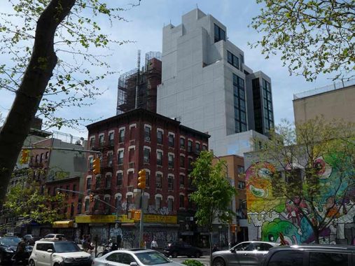
Chrystie Street is one of the few streets in Manhattan of any length, if not the only one, with no even-numbered addresses. All of the buildings on its east side were knocked down in the 1930s to build Sara D. Roosevelt Park. Not even the Municipal Archives’ 1940s collection features any of those buildings in its archive.
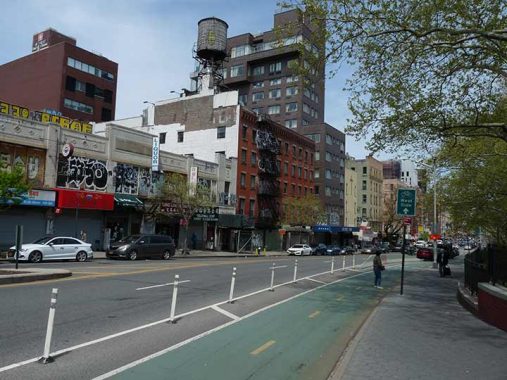
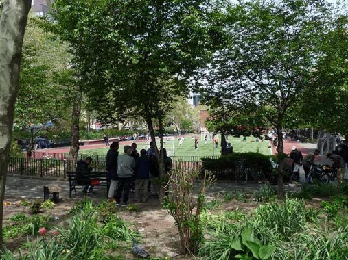
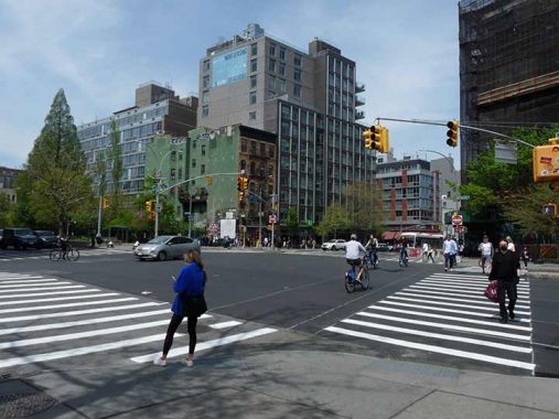
Chrystie Street falls outside of any protected Landmark District and thus, the buildings on its west side are a mishmash of very old plus new residential towers as seen here. A bicycle lane has been added in recent years on the park side of the street and the street can serve as something of a straightaway for cars and bikes alike, as it is crossed by only Delancey and Grand Streets as far north as Houston. However, there are pedestrian crossings at Hester, Broome, Stanton and Rivington and thus those intersections are controlled by stoplights.
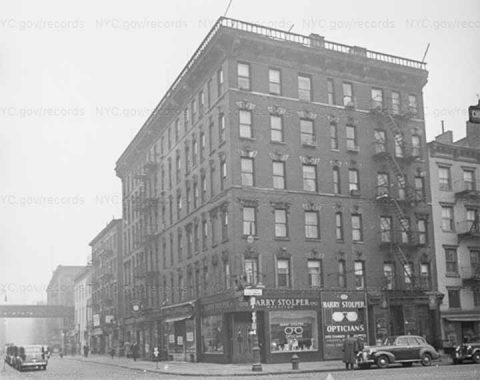
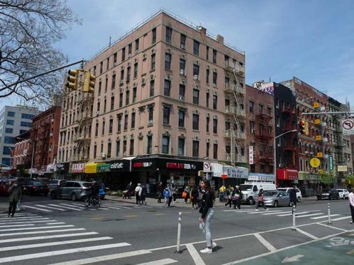
Here’s #73-75 Chrystie at Hester in 1940. This building exists today though in somewhat streamlined fashion. Barry Stolper Opticians occupied the ground floor; today it’s Kung Fu Tea. At left we see the 3rd Avenue El on the Bowery, which would be there until 1955.
I should mention that today Chrystie Street’s house numbering begins at #47, just north of Canal. That’s because it used to extend south to Division Street before both streets were truncated by the construction of the Manhattan Bridge in the 19-oughts. Division Street is fascinating, as it was much longer in the past and even had an elevated train clattering along it before it was severely cut back by a number of projects in the 1900s. It’s all here.
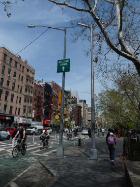
There isn’t much unusual infrastructure along Chrystie but I did find this at Hester, a pair of lampposts. The older one is on the right and was there before Chrystie Street had its eastern traffic lane awarded to bicycles. Its fire alarm indicator lamp is still in place, but not its streetlight.
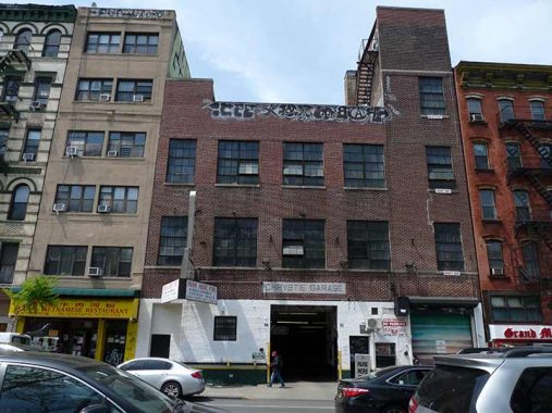
Designing parking garages that are at least not ugly has been a challenge for architects, probably the world over. Here’s one at #89 Chrystie that retains its original chieseled sign above the door.


There are a number of “they don’t build ’em like this anymore” moments on both Chrystie Street and 2nd Avenue and 101 Chrystie, also known as 253 Grand, is one. Until I pointed my camera at it, I didn’t know the building had a cartouche with the date of construction and the initials LB, which stand either for the developer, owner or architect. Not only that, I was completely unaware of the carven address 253 Grand, which is hiding behond the street signs, which I captured to show contrast.
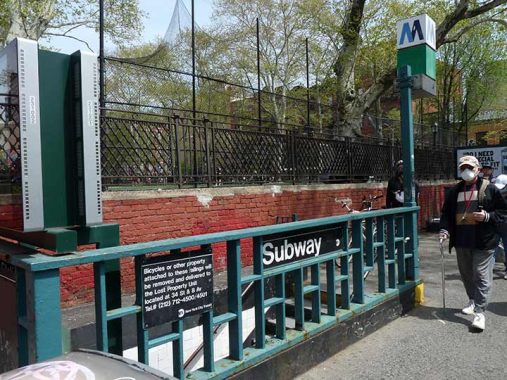
Believe it or not here we are looking at an entrance to one of the newest stations in the NYC subways, and it opened in 1967(!) when a connection from the 6th Avenue Line (today serving the B and D lines here) to the Manhattan Bridge was built, known of course as the Chrystie Street Connection. At the same time the 6th Avenue Line was connected to the Broadway (Brooklyn) Elevated, which permits today’s M trains to go from 6th Avenue across the Williamsburg Bridge to Brooklyn. (Andy Sparberg! Am I right?–Comments)
Here we see the former MTA logo, the two-tone blue M, which was supplanted in the 1990s by the “Doppler” MTA symbol.
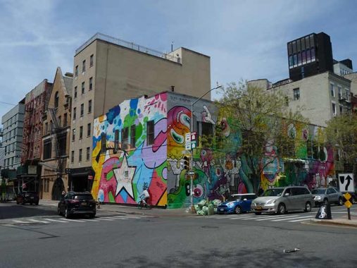
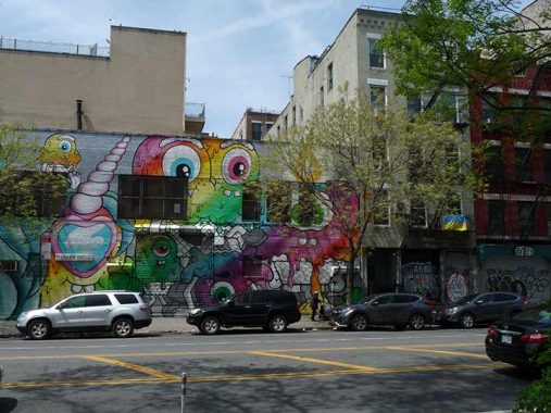
Totally bombed: Street art covers this building at Broome and Chrystie. To me, once you’ve seen Eduardo Kobra’s stuff, no street murals can really compare.
On the opposite side of Broome is an inadvertent comparison between the residential architecture of 1900 vs that of 2022. Perhaps a lack of soul with the one on the right, or a case of putting more money into interiors than exteriors…


The contrast between old and new is never greater than on the stretch of Chrystie between Broome and Rivington, spanning Delancey. I will say that the stylistic difference between residences and office towers is getting narrower and narrower all the time.
#195-199 Christie, included here, has a grim history. The property once served as the city’s second African Burial Ground, after the first one in the Civic Center was closed and desecrated with development. This cemetery received burials from 1795 until 1853. Most of the remains were reinterred at Cypress Hills Cemetery in Brooklyn, which hosts relocated graves from a few other small cemeteries that were decommissioned in favor of urban growth.
Street art acts as a palliative factor against the bland new buildings, and shows that robots have not yet assumed control.


The venerable building at #205 Chrystie, bordering Stanton and adjacent to a new glass and metal tower, is home to Rochelle’s, a bar known originally as Leave Rochelle Out of It; the painting of the legs and boots is, I imagine, Rochelle herself, a former girlfriend of each of the owners. Me being me, I was more interested in the metal signs with the street names, including the misspelled Chrystie. The signs aren’t evident in Municipal Archives photos from the 1940s and 1980s (though both are pretty fuzzy). I wonder when these signs first appeared.
From Sergey Kadinsky’s Sara Roosevelt Park page:
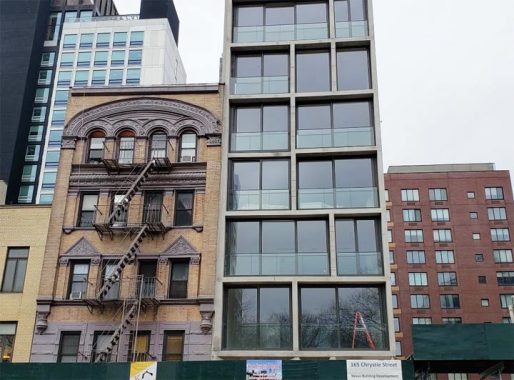
163 Chrystie has a German Rundbogenstil, or “round arch style.” This was a mid-19th Century attempt in Germany to develop a national architectural style. Kevin’s tour of 14th Street from October 2019 offers more examples of Rundbogenstil. Next door, 165 Chrystie offers the post-millennial look of floor-to-ceiling glass windows and concrete walls. Designed by ODA Architecture, the 9-unit luxury residence replaced a three-story Chinese kitchen supply store.


The inclusion of sculpted birds on park lampposts at Sara D. Roosevelt Park’s northern end at Chrystie and East Houston is no mere random whim on behalf of NYC Parks. It’s my bet that these birds honor the Hua Mei Bird Garden, a short distance away at Delancey and Forsyth. Vanishing Jeremiah discusses it thus:
Hanging in trees, from poles, around the chain-link fence, and sitting on the leafy ground, are dozens of beautiful bamboo bird cages, some half shrouded in white cloths, most of them ornately carved, and all containing a songbird.
Many of the birds are small–colorful finches, a few black-capped chickadees–but some are the Hua Mei, a fighting thrush from China for whom the park was named.
Many Chinatown residents keep caged birds and the garden was instituted serendipitously in 1995. Unfortunately the garden was closed, at least temporarily, after druggies and vagrants reasserted their presence in SDRP. Hopefully, the garden will reopen soon if it hasn’t already been.
New York City didn’t have a grand overall plan to design the streets of the Lower East Side. When farms were subdivided, a very early map, the 1801 Mangin-Goerck Plan or Map of New York City, mapped out the streets we now find in the area. For a number of reasons it was found unsatisfactory. Later, the Commissioner’s Plan of 1811 codified the streets north of Houston, which was originally called North Street simply because it was the city’s northern end.
Traffic flows from the north south streets across Houston into the avenues north of Houston. Thus, Chrystie Street runs two ways, but northbound traffic can’t enter 2nd Avenue, which is one-way southbound.
Of the other Lower East Side Streets that flow into avenues above Houston…
Allen Street (two-way) ➡️ 1st Avenue (northbound)
Essex Street (two-way) ➡️ Avenue A (two-way)
Clinton Street (northbound) ➡️ Avenue B (two-way)
Pitt Street (northbound) ➡️ Avenue C (two-way)
Columbia Street (two-way) ➡️ Avenue D (two-way)
I was grateful for my luck when I saw the metal gate of the New York Marble Cemetery open on 2nd Avenue between East 2nd and 3rd Streets, but I shouldn’t have been surprised, as the cemetery is open to all comers during its outdoor board meeting the first Sunday in May.


The NY Marble Cemetery (NYMC) is unique in New York City in that it contains no freestanding gravestones, and never has had them. The NYMC — along with the nearby New York City Marble Cemetery (NYCMC) (East 2nd Street between 1st and 2nd Avenues) were developed by the same person, Perkins Nichols, beginning in 1830, when East 2nd Street was still considered uptown. Instead of earth graves with headstones, family vaults the size of small rooms were built ten feet underground. The relatively deep location was decided on because at that time there was still fear of contamination from deadly or debilitating diseases from fresh remains. The vaults are set in pairs and can be accessed by removal of stone slabs set beneath the “lawn.” The NYMC contains 156 vaults and 78 entrances, with a total of approximately 2100 interments.
Among the original internees were prominent businesspeople, what today some would call the “one percent.” Uriah Scribner, a founder of the Scribner publishing and book-selling empire; Aaron Clark, NYC’s first Whig mayor, and second popularly elected (from 1837-1839); US Representative and President of Columbia University, James Tallmadge; Benjamin Wright, Chief Engineer for the Erie Canal; and Deys, Varicks and other prominent names found on NYC street signs.
See FNY’s All the Marbles page for info on both cemeteries.
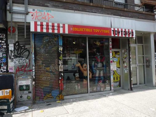
Toy Tokyo, at #91 2nd Avenue, is an emporium featuring rare and collectible toys and a premier location to find merchandise from famed toy designers such as Funko, Kaws and Ron English. In addition, unique vintage toys, model kits, games, dolls, and stuffed toys are also offered. Toy Tokyo specializes in rare and collectible Godzilla merchandise including everything from full-body Godzillas to build-it-yourself models, some of which are rare and sell for over $600. The store has been voted Best Toy Store of the Year by Clutter Magazine, a premier source for counterculture and art toy information.


Block Drugs’ red neon sign on the SW corner of 2nd Avenue and East 6th, which (unofficially) goes back to 1948, still lights up brilliantly at night. Block has been in business since 1885, as the corner of the sign indicates. In the windows, there are smaller red neons, one of which says “Cut-rate Cosmetics.” If that date is correct that puts it among NYC’s oldest extant businesses, but surprisingly, it didn’t make my Bible on these matters, Ellen Williams & Steve Redlauer’s Historic Shops & Restaurants of New York (Little Bookroom, 2002).
This seems to be the last survivor of a franchise. From wikipedia:
The company was founded in 1907 by Alexander Block, a Russian immigrant who had a small drugstore on Fulton Street in Brooklyn, New York. He turned the company into a wholesaler in 1915, then became a drug manufacturer in 1925, acquiring a 50 percent interest in Wernet’s Dental Manufacturing Company…
Block Drug Company was a pharmaceutical company based in Jersey City, New Jersey, United States, that specialized in dental care products. Its most popular products included Polident denture cleanser, Poli-Grip denture adhesive, Dentu-Creme denture toothpaste, Nytol sleeping pill, Tegrin medicated shampoo for psoriasis, Lava hand soaps (acquired from Procter & Gamble), Beano and Phazyme anti-gas products, Balmex diaper rash ointments, and Sensodyne desensitizing toothpaste.[1]
GlaxoSmithKline purchased the company for $1.24 billion in 2001.


A walk down several streets of the East Village, especially St. Mark’s Place, Cooper Square, 2nd and 3rd Avenues, and east 6th and 7th Streets, and you’ll notice dozens of lampposts whose bases and lower halves are covered withe ceramic tile, glass, broken crockery, rhinestones, terra cotta and other small decorative pieces. Some are arranged in patterns that spell out the names of fallen firemen on 9/11/01; politicians; local landmarks and theatres. They are all the work of Irish-born Vietnam vet Jim Power, who has been adding this embellishment for over twenty years and has become a beloved East Village institution.
Power’s work is especially necessary at the NW corner of 2nd Avenue and east 6th Street, the site of the 1968-1971 Bill Graham rock palace, the Fillmore East. Graham took over the old cinema/Yiddish theatre in early 1968 and for two full years and part of two others presented a roister of superstars that to this day reads like a classic rock radio playlist. Just about every big name in rock and roll except the Beatles and Stones played the Fillmore East (Graham’s east coast counterpart was the Fillmore West in San Francisco.)
No official plaque marks the spot of the Fillmore East (and none, for that matter, marks the locales of other legendary NYC rock venues such as CBGB, the Palladium, Bonds of Times Square, Folk City, Max’s Kansas City, the Peppermint Lounge (either of them), Danceteria, the Ritz, the Lone Star Cafe…I could go on. Read the full FNY report at the former Fillmore East location here.


Without question, lower 2nd Avenue has sen its share of disasters during the past decade. The Tiffany windowed, double-spired Middle Collegiate Church has stood on 2nd Avenue between 6th and 7th Streets since 1892. Just next door is 110 2nd, the Isaac T. Hopper House, built in 1839, which early on in its history was a “home for wayward girls” instituted by Hopper, an abolitionist Quaker. It is the lone survivor of a set of four such Greek Revival townhouses. 110 2nd is the headquarters of the Women’s Prison Association, which assists women who have served time in the criminal justice system. Middle Collegiate Church, as well as the corner building to its immediate north, were completely gutted by a fire in December 2020 and the church awaits a rebuild.
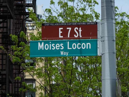
Meanwhile, the northwest corner of 2nd Avenue and East 7th Street was rendered an empty lot after three former buildings on the site were wiped out by an explosion, killing two, caused by an illegal tap into a gas main in March 2015. The landmarked buildings were constructed between 1835 and 1901. The corner building was the longtime home of popular thrift shop Love Saves The Day. However, a new building has since gone up on the site. The two men killed in the blast, Nicholas Figueroa and Moises Locón, have been remembered on street signs.
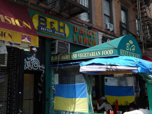
I haven’t been in B&H Dairy Lunch at #127 2nd Avenue between East 7th ands St. Mark’s Place, but it’s a token remembrance of the formerly heavy Jewish population of the Lower East Side, which has also attracted numerous German, Ukrainian, Polish and other Eastern European immigrants in a rich past. I will defer to the New York Magazine review:
This shoebox-sized kosher dairy restaurant is one of many that once peppered Manhattan. Today, more than 60 years since it opened, a largely Hispanic staff continue to turn out Yiddish comfort staples: crisp latkes, knishes the size of pillbox hats, and plump pierogis your bubby might serve. Bowls of vegetarian borscht and lima bean and two of the half-dozen daily soups add spots of color. A rotating cast fills the dozen stools and the six small tables that hug the opposite wall. Weekend nights and brunch hours draw scruffy, pre- or post-bar-hopping sorts hunched over eggs and home fries, challah French toast, blintzes, or matzoh brei. Midweek is more Hopperesque, the profiles of solo diners washed in the sallow glow of the diner’s hanging milk-colored lights. No matter when you step up to the counter, a double stack of sweet-soft challah, schmeared with butter and served on a small Dixie plate, accompanies every order. The motto “Better Health” could be taken ironically if not for the juice bar — which provides wheatgrass shots and fresh juices to a steady stream of to-go customers — and that zingy borscht, light on the sour cream, thank you.


There may have been a concert garden on the site of the Orpheum Theater at 2nd Avenue at St. Mark’s Place as early as the 1880s, but there was a theatre there by 1904. During the heyday of Yiddish theatre in Manhattan, the venue was the “Player’s Theatre”, and was part of the “Jewish Rialto” along Second Avenue. By the 1920s, the theatre was exhibiting films, but was converted back to dramatic use in 1958, with the first production, Little Mary Sunshine, opening in November 1959.
Significant productions include the revival and revamping of Cole Porter’s musical Anything Goes in 1962, Little Shop of Horrors in 1982, Sandra Bernhard’s Without You I’m Nothing in 1988 and David Mamet’s Oleanna in 1992. Stomp has been here seemingly forever, but only since 1994. What musical instrument is depicted in the frieze?


Site of Gem Spa, which occupied the key SW corner of 2nd Avenue and St. Mark’s Place for decades. Opened in the 1920s and operated under the Gem Spa name since 1957, it was said to be the birthplace of the classic NYC egg cream (which combines milk, chocolate syrup and seltzer, but no eggs or cream) and received magazines a couple of days before anywhere else. Crowds would congregate to get the Village Voice on Wednesday nights.


Two deep-red brick buildings on the west side of 2nd north of St. Mark’s Place appear as if they were built at the same time and by the same architect and indeed both were designed by William Schickel and completed in 1884.
The Freie Bibliothek und Lesehalle (Free Library and Reading Room) and next door, the Stuyvesant Polyclinic, are both remnants of Kleindeutschland, the primarily German population that lived in the area in the late 1800s to early 1900s. The General Slocum disaster and America’s entry into World War I served to dissolve the clinic’s early German association, however, but the German inscription can still be seen over the library, now the Ottendorfer Branch of the NYPL.
The facade of the clinic is festooned with busts depicting both real and mythological physicians and scientists of the classic Greek and Roman eras (such as Aesculapius), and also from the Europe of the 1880s (Anders Celsius).
Many sidewalk signs along 2nd Avenue (gradually dwindling though) attest to the presence of Eastern European immigrants.


Veselka is a Ukrainian restaurant beloved in these parts. The restaurant was established in 1954 by Ukrainian immigrants Wolodymyr and Olha Darmochawal as a candy store/newsstand and is a reminder that the East Village was once populated by thousands of Eastern European immigrants. It’s known as the pierogi and borscht capital of Manhattan. The MB on the pediment may be the building’s original architect or owner in the early 1900s.
Since I have never had pierogis, this may be the place to do it. I have been in Veselka only once, about a dozen years ago.
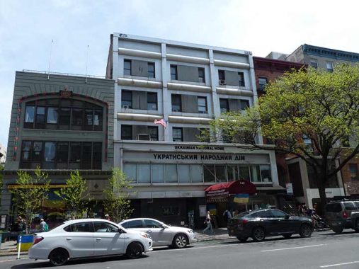
Another Ukrainain-themed restaurant, Ukrainian East Village Restaurant, can be found next door, at the Ukrainian National Home at #140-142 2nd Avenue. The restaurant has been there since 1963 and some reports say the building itself has stood since the 1830s.
Those pierogi punctuated my college experience: They were a balance of cloud-like potatoes (sometimes mixed with cheese or bacon) stuffed into chewy wrappers and scattered with fried onions. [Tasting Table]


The Baptist Tabernacle, #166 2nd Avenue between East 10th and 11th, has its origins on Mulberry Street in 1839, but moved into a church on the site in 1850; that building stood until 1928 when it was demolished, but a worship space was included in the new Emery Roth-designed apartment building: teh script “Baptist Tabernacle” can still be found over the door. Services haven’t been read here in years and the space is now home to that new form of worship, Urban Outfitters.
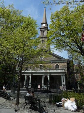
The centerpiece of the East Village, of course St. Mark’s Episcopal Church, is across 2nd Avenue. St. Mark’s In The Bowery, at 2nd Avenue and East 10th, is the oldest building on 2nd Avenue, dating to 1799, with additions in 1828 (the steeple) and 1858. Most of the church had to be rebuilt after a devastating fire in 1978. It stands on the chapel site of Peter Stuyvesant’s 17th Century estate (the Director-General is interred in a vault in the churchyard, as his great-grandson sold the property to the Episcopal Church in 1793) and is turned to face Stuyvesant Street, once the driveway to the estate.
St. Mark’s claims to be the oldest site of continuous worship in NYC. NYC mayor and diarist Philip Hone and NYS Governor and US Vice President Daniel D. Tompkins are also interred in the churchyard.
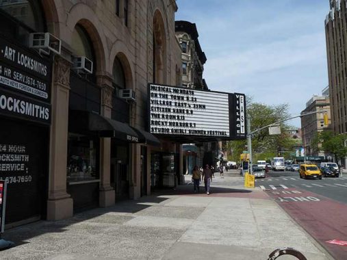
Village City Cinemas was developed by Louis Jaffe in 1925 as the Yiddish Art Theatre, as part of the many theaters featuring productions in the Yiddish language spoken in Eastern Europe. Composers Ira and George Gershwin got their start here, as well as Broadway and Hollywood’s Paul Muni and Edward G. Robinson. After a turn as the Phoenix Theatre, it was later named for the developer and is now Village East City Cinemas.
Tradition is upheld with a classic plastic-lettered marquee.
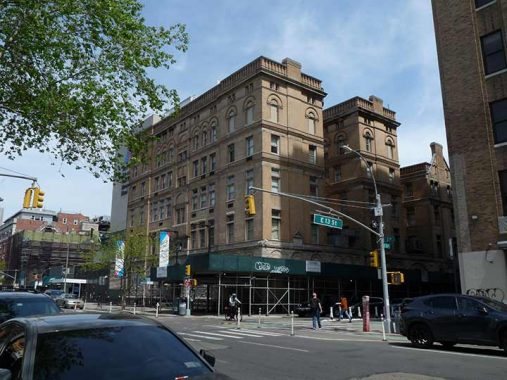
Until I found an ophthalmologist closer to home, in Manhasset, I got my peepers peeped at in the historic NY Eye and Ear Infirmary, constructed in a Romanesque Revival style in 1893 on 2nd Avenue from East 13th to East 14th Street. Scenes from The Godfather were filmed within.


Kicking it in the head for today at the W. M. Evarts at 2nd Avenue and East 14th. Who’s Evarts, you say? Could the U.S. Senate ever have met in this building? Extremely unlikely, since if you’re looking for the last time the U.S. Congress met in New York City you have to go all the way back to August 12, 1790, in the long-vanished original Federal Hall in lower Manhattan. In fact, this part of Manhattan, where the apartment building currently is, was still mostly open country back in 1790. (Congress did meet in a special joint session September 6, 2002, in Federal Hall on Broad and Wall Streets to commemorate those killed in the terrorist attacks nearly one year before.)
So what’s going on? Take a look at the entranceway closest to 14th Street. You’ll find, in much smaller carved letters, the words “The W.M. Evarts”. William Maxwell Evarts was a Republican Senator from New York in the years 1885-1891. Perhaps the architect was a Republican, or an Evarts supporter. Never heard of Evarts? I wouldn’t have either…but thanks to perhaps a supportive architect, and sheer luck that this edifice has survived for at least 109 years, his name’s still out there.
As always, “comment…as you see fit.” I earn a small payment when you click on any ad on the site.
5/15/22
7 comments
The video of the fire that destroyed Middle Collegiate Church is almost incomprehensible, given the utter ferocity of the flames. Massive FDNY hose streams might as well have been trickles from a little kid’s squirt gun for all the effect they had.
https://www.youtube.com/watch?v=ftw9j1xEmlc
“Chrystie Street is one of the few streets in Manhattan of any length, if not the only one, with no even-numbered addresses”
You want to see a street with only even-numbered addresses, on both sides of the street? See Angelo Cifelli Drive in Harrison NJ. It’s exciting because they are building entirely new street infrastructure from scratch, and it’s urban, grid-style development. But a couple days ago I noticed the big address numbers on expensive metal signs across the street from each other. One said 330 and the other I regrettably forgot but it was even. There’s a slight chance one of the numbers reflected an actual address in Somerset Street, on the other side of the block, but I’m not sure. Got to check Harrison out, Kevin! Several full blocks of Urby-built apartments next door to heavily active warehouses built in the mid 1900s. Right near the PATH station.
The Provenzano Funeral home next to the cemetery(how convenient!)used to have
a Chevy statiion wagon for a hearse for “Econo” funerals.God only knows the quality
of the coffin that was included in that package deal.I would have died again from the
sheer embarrasment.
There was a Ratners dairy restaurant next to the Filmore East but it sounded gross
so I never went there.
In the 60s St. Marks in the Bowery was broken into so many times it was more like
it was looted instead of robbed.I remember seeing it in a episode of Naked City where
the combat vet goes koo-koo and starts shooting people.Before he does though,he
stocks up with some guns and ammo at-where else?Kauffmans army-navy on Broadway!
The best surplus store in the city! Everything was so cheap there you wondered how in hell
they turned a profit,it just staggered the mind
Manhattan Eye, Ear, Nose and Throat Infirmary as it used to be called was where I had my tonsils removed back in 1950. They
must have done a sand blasting to the original stone facade because I remember the building being a very dark stone.
Kevin, thanks for mentioning me. You are correct – the Chrystie Street Connection was part of a larger, five part project that joined the BMT trackage on both East River bridges to the IND Sixth Avenue Line. The first part of the Chrystie project opened in 1962 when the tracks between DeKalb Avenue and the Manhattan Bridge were reconfigured for the future train services.
The other four pieces debuted in 1967 and 1968. Specifically, the Manhattan Bridge connection (including the Grand Street Station pictured), and the two lower level tracks under Sixth Avenue between West 4th and 34th Streets, opened November 26. 1967. The Williamsburg Bridge connection, and two new tracks between 47th/50th Sts. and a new station at 57th Street, opened July 1, 1968. The 57th St. station was needed to provide a terminal for the Williamsburg Bridge trains. That route was eventually connected to the 63rd Street Tunnel, and F trains have used it since 2001.
B and D trains have served Grand Street and the north side Manhattan Bridge tracks since 1967. Broadway (Manhattan) BMT trains were shifted to the bridge’s south side tracks at then same time. For a number of years train traffic on the Manhattan Bridge was restricted as the bridge was gradually rebuilt, but now all four tracks are in daily use.
The Williamsburg Bridge connection was not used in revenue service from 1976 until about 2010, when the current M service was established between Metropolitan Avenue and Midtown Manhattan. Non-revenue, or equipment train moves, did use this connection but passengers were not carried.
I think musical instruments depicted in the frieze are a Pan Pipe and a Shawm. The shawm is a loud double-reed instrument which is the ancestor of the oboe.
55 Christie was a former Sneaker factory. As well as a brewery. It was also the Beasty Boy hangout. When I lived there it was a rifle range and Bordello