

THURSDAY, November 23, 2017, Thanksgiving Day, dawned sunny and bright. I usually have been at one cousin or the other’s Thanksgiving extravaganza but that year, they were doing it on the weekend, thus I was at loose ends. Perfect photography conditions, though, if I didn’t mind the harsh shadows. So I hatched a plan. Why not link two neighborhoods that have nothing to do with one another with a walk? I arrived at Sunset Park to Maspeth, which would take me through Borough Park, Lefferts Gardens, Crown Heights, Bedford-Stuyvesant, Bushwick, Ridgewood and Maspeth. I walked from the light of day to the dark of night, nonstop (maybe a bathroom break, I forget). To my surprise it totaled only 12-13 miles; I know people who have walked triple that in one walk. It’s 8 years later, and at age 68, my back as well as other parts will no longer permit a nonstop walk like that. It’s not my longest: that was the full length of Metropolitan Avenue, Williamsburg to Jamaica, in May 2015.
I obtained over 300 photos; I won’t use them all but I’ll be splitting this walk into multiple pages to avoid the ever-present TLDR issue. And to make it easier on me.
GOOGLE MAP: SUNSET PARK TO MASPETH
^ Open the map in a separate browser window and follow along with me!


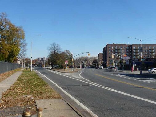
I took the N train to 8th Avenue, the first station in the open air after the N ends its partnership with the R on the 4th Avenue Line. From here the N makes a straight line south to Coney Island and is known as the Sea Beach Line from its former era as a surface steam railroad. In 2017, and for a couple of years thereafter, the Sea Beach stations were undergoing a top to bottom renovation and trains employed the little-used center express track, skipping a number of local stations. On those stations the N stopped, like 8th Avenue, temporary platforms like the one shown here were employed.
When I lived at 73rd Street and 7th Avenue from 1982-1990, I split my time depending on my mood, using either the 77th Street R station or the 8th Avenue to catch trains to Manhattan.


I have always considered the exterior BMT stationhouses constructed in the 1910s unsung heroes of the system. They don’t get the good press that the older ones for the IRT designed by Heins & LaFarge in the 19-ohs have gotten. They are workmanlike and sturdy, featuring beige tile work with occasional colored terra cotta flourishes. My friend Philip Coppola, chronicler of subway design, has an upcoming volume about them. I saw several on this walk. The 8th Avenue station was still under construction, and looks much better eight years later.


Soccer Tavern, 8th Avenue near 60th Street, was likely named for the nearby soccer fields at the (former) Dust Bowl at 8th Avenue and 65th Street. It has served a variety of nationalities over the years. It has been the Soccer Tavern for over seven decades and now has a mixed Irish and Chinese clientele. Only in New York, kidz! In 1940 it was known as Kerr’s Bar & Grill.


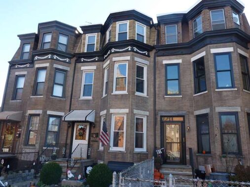
Dwellings on 60th Street between 8th and 9th Avenues. You can see different philosophies of residential architecture and you can probably guess which I prefer.
This building with the chamfered, or slanted, edge on 60th Street and Fort Hamilton Parkway has had many uses over the years. As a kid trundling past on the B16 bus in the Swinging Sixties I knew it as an auto showroom for Rogers Pontiac. In the 1980s, it was a roller skating rink called United Skates of America (which still has locations elsewhere). Meanwhile, in the 1940s, it was a Borden’s ice cream and cheese factory! Today, there are apartments upstairs and beauty supplies and medical offices on the ground floor.


I nipped over to 61st Street and Fort Hamilton Parkway to get photos of both the FHP and 11th Avenue stationhouses, which open to the north and south ends of the platform. They look much the same as when they opened in 1915 except for the lighting fixtures; I later saw a station with the original sconces on this walk.


Sampler of ancient dwellings on the north side of 60th Street between 11th and 13th Avenues. These may have been here before the nearby Sea Beach RR was placed in a trench, electrified with a third rail and became the N train (so called for the first time in the 1960s).


I decoded to take 13th Avenue, which is something of a time capsule, as it runs through a Hasidic neighborhood (one of three in Brooklyn along with Williamsburg and Crown Heights, which I saw later in the walk). The avenue is something of a sidewalk sign museum. While Borough Park is thought of as an Orthodox and Hasidic Jewish neighborhood there is also an Eastern European pocket. I passed stores like Cracovia, which sells Polish imports (it has closed since 2017) , and Kek Duna, Hungarian. There are world within worlds, I like to say.


There are Catholics to be found anywhere in NYC, and Saint Frances de Chantal Church, 13th Avenue and 57th Street, sees to the needs of southern Borough Park’s. This was the parish church, and former elementary school, of my aunt Mary, uncle Jim and their three kids, my cousins, when they lived for many years on 13th Avenue and 50th Street. The saint was a French nun (1572-1641) who founded the Order of the Visitation of Holy Mary. It’s one of the older parishes, as the church’s cornerstone was laid in 1909. The parish school closed decades ago and now houses the Guild For Exceptional Children.
There is a statue of St. Florian (250-304), a commander in the Roman army who refused to persecute Christians in the pre-Constantinian era, and was subsequently martryred. He is venerated in Poland, Hungary and Austria. “Florian is a patron saint of Upper Austria, Poland, firefighters, chimneysweeps, soap boilers, and brewers. Florian is associated with brewers because of a legend in which he miraculously stopped a fire with a single pitcher of water, thus the frequent depiction of him holding a pitcher.”–wikipedia


Sidewalk sign sampler on 13th Avenue between 53rd and 39th Streets. Many of the signs are decades old and are sun faded, but get the job done.

Though many neighborhoods were preternaturally quiet on Thanksgiving Day, not so in Borough Park and Crown Heights, where it was business as usual.


A walk down 13th Avenue is also a walk down Memory Lane. I visited #1303 50th Street at 13th Avenue: it was here that my relatives mentioned earlier, a family of five, lived in a smallish two-bedroom apartment on the second floor. I wasn’t paying attention to architectural detail then, and didn’t notice the cherubs over the front entrance.
This stretch of 13th Avenue is one of many streets and parks named for Raoul Wallenberg. The Swedish diplomat (1912-1947) is credited with saving tens of thousands of Hungarian Jews from extermination by the Nazis in the World War II years by designing counterfeit passports and distributing them to Jews bound for the concentration camps. He also purchased as many houses, villas, and buildings as possible and adorned them with the blue and yellow of Sweden’s flag, thereby making them neutral diplomatic property and a safe havens for Jews. His whereabouts became unknown in 1945. In 1957, documents were released stating he had died of a heart attack in 1947 in a Russian prison. Suspicions remain that he was killed by the KGB.
You can just tell by looking at buildings that they originally had a different purpose, like #4124 13th Avenue which hosted a theater between 1920 and 1950, known originally as the Royal and for its last 10 years as the Radio Theatre.

While open-air markets have mightily multiplied in New York City in the last 20 to 30 years or so (the farmers’ markets in Union Square and Grand Army Plaza in Brooklyn, for two instances, as well as the Brooklyn Flea and other varied “fleas”), there was a time when they were considered unsanitary and undesirable, not just the large ones that fill empty lots but even the lone entrepreneur with his pushcart. Among the reasons for this is that these markets were unregulated and visited rarely by health inspectors. After NYC’s former Department of Markets was established in the 1920s, things improved somewhat but not enough for Mayor Fiorello LaGuardia when he took office in 1933.
The Little Flower spearheaded a Works Progress Administration initiative to build indoor markets throughout the city to improve sanitation and make inspections easier. These markets’ design was very simple, no-frills Machine Age, with no ornamentation whatsoever, and sanserif lettering on signage. There are a few of these left — the original Essex Street Market near Delancey is still standing, though now endangered, and the 1st Avenue Retail Market infrastructure remains in place, though an apartment tower has been built over it and the market space is now Theatre for the New City.
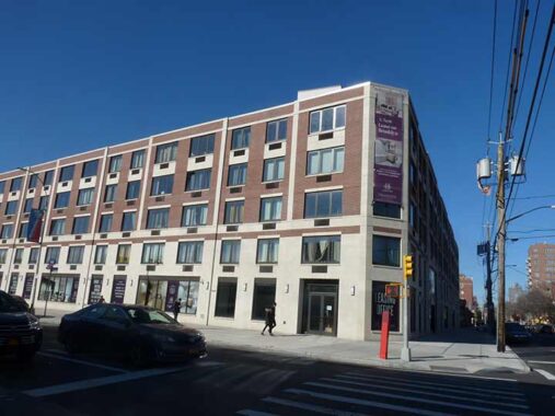
The Thirteenth Avenue Retail Market between 39th and 40th still looks almost the same as it did when it was built in the late 1930s, though a small central sign saying “City of New York Department of Markets” has been removed. The 13th Avenue facing is no longer the main entrance, though, as a new entrance was constructed on 40th Street.


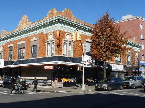
In 2016, I was surprised to see something I had never noticed on this building on the corner of 13th Avenue and 39th Street — given that I had passed it hundreds of times on a bicycle or going by in a bus. First of all it’s a magnificent apartment house with stores on the ground floor, and heavily lentiled arched windows on the second. Most of the original roof treatment is still intact. It was on that corner bay that I noticed some serifed script that says:
THE. ABELS. & GOLD. BUILDING.
From this, my alter ego, Captain Obvious, would deduct that two persons named Abels and Gold commissioned the building somewhere between, I’d guess, between 1890 and 1910, and the periods after every word are an orthographical affectation — although I’ve never seen periods used quite this way in anything I’d seen before.
Another possibility — slim — is that the period after “THE” indicates that it’s an abbreviation, possibly for “Theodore.” I’m rereading my now-dogeared copy of Luc Sante’s “Low Life” and within it we meet Bowery saloon keeper The. Allen, known in his day as “the wickedest man in New York” (yes, the title has changed hands many times). Sante does not say that “The.” is short for Theodore, but that’s my interpretation. I think, though, the the first explanation, typographical whimsicality, is the best one.
ForgottenFan Yitzchok Shteierman found an article in a 1907 Real Estate magazine about Mr. Abels and Mr. Gold. As it turns out the period is there as a decoration only, and Mr. Abels’ name was Simon. I have the full story here.


Why photograph a nondscript building and an empty lot at 13th Avenue and 37th Street? It’s about what’s not there anymore. Until 1985 there were elevated railroad tracks here, the remnant of the Culver Shuttle which ran between the 9th Avenue station on the West End Line (today’s D train) and Ditmas Avenue above McDonald Avenue on the F. The tracks once belonged to the Culver El, which connected the old 5th Avenue El and Coney Island, but was “orphaned” in the 1950s when the IND was extended past Church Avenue to Ditmas. The line ran as a shuttle train for 20+ years until 1975. And, tracks belonging to the freight-only South Brooklyn Railroad ran at grade under the el. By the 1970s, freights were few and far between, so local Italian guys set up a bocce court south of 13th Avenue and the old man and I would occasionally watch.


If you look at the Brooklyn map, there are a quartet of short streets between 36th Street and Dahill Road: Minna, Tehama, Clara and Louisa Street.
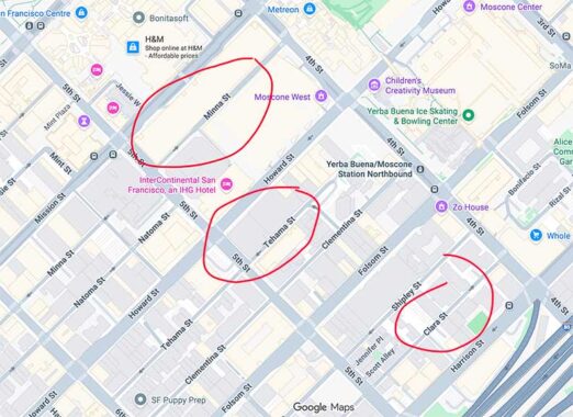
But if you look at a map of San Francisco, three of the names, Minna, Tehama and Clara, pop up in the South Market neighborhood. I call this the Transcontinental Mystery, exploring it further on this FNY page. Long ago, apparently, 12th Avenue was Clementina and that, too is in San Fran. See comments on the link for insights.


Another pair of short streets can befound between Ft. Hamilton Parkway and Minna Street, Micieli Place and Bills Place. “The [Brooklyn] Eagle issue of June 18, 1942 (pg. 7, col. 4) reports: “One measure creates Bills Place in memory of Pvt. Matthew Bills, who lived at 921 New Utrecht Ave., and the other creates Micieli Place in memory of Second Lt. Frank J. Micieli, who resided at 70 Dahill Road.” The legislation naming the new streets was introduced by Councilman William McCarthy and signed by Mayor LaGuardia.


The entrance to Green-Wood on the north side on Fort Hamilton Parkway is flanked by two extraordinary Victorian-era buildings. Richard Upjohn’s massive arch at 5th Avenue and 25th Street gets most of the press, deservedly, but the buildings here, on what can be considered the Cemetery’s rear entrance, are almost as impressive. On the left side of the FHP entrance is the cemetery caretakers’ residence and on the right side is the Visitor’s Lounge. According to the cemetery’s website, “the cottages offered a welcome place to rest after one’s often-long journey to the cemetery, and recall the front parlor of a contemporary brownstone rowhouse.” Both buildings were designed by Richard Upjohn’s son, Richard Mitchell Upjohn, and reflect architectural sensibilities completely lost in the modern era of minimalism. Four sculptures depicting the “Ages of Man” by British sculptor John M. Moffitt (1837-1887) are carved in brownstone on the lounge exterior walls.


With daytime at a premium, I had little time to pause in the Cemetery, but poked my camera through the fence and captured some monuments, as well as surviving fall color.
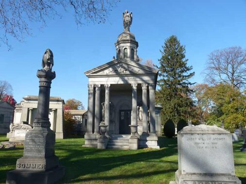
One notable tomb visible from FHP is Charles Feltman‘s monument, visited on ForgottenTour #100 in 2015. Feltman, the purported inventor of the hot dog (it was originally a sausage served on a roll; the roll’s distinctive shape and the hot dog’s mild recipe evolved later on) operated a food wagon in Coney Island beginning in 1867, and by 1874 the profits from his hot dogs enabled him to build his Feltman’s Ocean Pavilion. By 1946, when the restaurant finally closed, billions of frankfurters (also called since the sausage on roll treat had also arisen in Frankfurt, Germany as early as the 1500s) had been sold. This, one of the more elaborate tombs in the Cemetery, must have cost a lot of frankfurters. There is still a brand for sale, Feltman’s of Coney Island.
At Dahill Road, FHP’s eastbound traffic is directed onto Caton Avenue (right), a main auto and truck conduit to Linden Boulevard. I remained on Fort Hamilton Parkway, which leads to Ocean Parkway, but is one way west only.
Now entering the neighborhood of Kensington. As mentioned on the Names of the Neighborhoods of Brooklyn page, the neighborhood is named for a western borough of London; there are many British-sounding place names in the area, mostly by design since in the mid-1800s, when the region was developed, a patina of sophistication was desired. There were scattered farms around until the 1850s when the Coney Island Plank Road (Coney Island Avenue) was built and some dwellings began to concentrate at Coney Island and Church Avenues, as well as the northern end of the area near Ft. Hamilton Parkway. As early as 1851, the street pattern began to appear.
Fort Hamilton Parkway between East 4th and 5th. I always liked bay windows like this, since you get three separate views of the facing street.


Immaculate Heart of Mary Catholic Church, Fort Hamilton Parkway from East 4th to East 5th Streets was designed by prolific ecclesiastical architect Henry V. Murphy in 1931, combining Art Deco and Gothic elements. The parish was founded in 1893.
The intricately carved blackletter Latin above the entrance translates to: “temple of the Lord,” “is holy to God,” “structure of God” and “it is a building.”
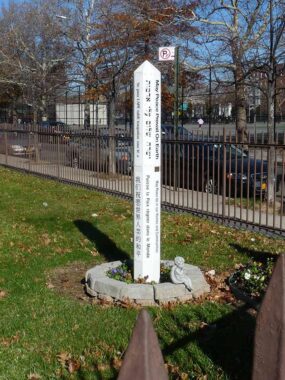
The phrase “May peace prevail on earth” appears on this stile, translated to many languages.
While traffic here is one-way west only, pedestrians face no such restrictions, and I was easily able to walk over to Ocean Parkway…


The short east-west stretch of Ocean Parkway between Prospect Expressway and Ocean Parkway contains some beautifully designed apartment buildings. The fire alarm looks like a John Colgan special.
Next: on to Prospect Park and Lefferts Gardens
11/28/25
8 comments
Alright! An Optimo cigar sign! Like straight out of a Reginald Marsh
painting.Though here the store’s owners have copped it for their own
use.Who cant help but dig a style of lettering like that.
I love Feltman’s Hot Dogs. Too bad the stand was closed in Coney. I used to buy them at Stop & Shop in Rockaway Park for $6.99 for a pack of six dogs All of a sudden, they weren’t available anymore. I contacted Mike Quinn, the owner, and he said that the dogs were available at all major supermarket chains. They’re not. The website used to have a page with places where one could buy them. That was removed. The only way to get them is by ordering from the website. Like I said, I like Feltman’s; but, I ain’t paying 75 bucks for 3 six packs ans two bottles of mustard.
The 2800 block of Fort Hamilton Parkway used to have more rowhouses like those pictured. Several were demolished in the mid 60s to make way for the Windsor Terrace Branch of the Brooklyn Public Library. I remember some sort of a stone block in the sidewalk in front of that row with the date of their construction, which appears to have been removed when the Library was built. I checked the 1940s tax photos but could not find any such stone block.
I vividly remember that very fire alarm at Ocean Parkway and East Seventh Street. I would have been about five at the time and was walking with my uncle. Out of curiosity I reached up and pulled back the outer covering. He immediately yanked me back from the box before I could even think of touching anything else. He was FDNY and I got quite a lecture that day!
About 10 years ago I posted about my experience with that “quartet” of streets – Minna, Tehama, Clara, and Louisa. I’ll paste it in:
In the early 60’s I used to deliver The World Telegram & Sun throughout Borough Park. All the streets and avenues were numbered, so it was nearly impossible to get lost, and you could gauge how long it would take to complete a route. One afternoon, the manager asked me to come back to the office (52nd St and 18th Ave) after my regular route and deliver for someone who was sick. When I got back, he gave me the list of subscribers on Clara, Tehama, Minna, etc. I had NO idea where these streets were!. He said “Just head up Old New Utrecht Road to 17th Ave, then up to Dahill Rd, and you’ll see them when you cross Church Ave.”. We had a short section of Dahill Rd. near where I lived on 51st St, so I figured it couldn’t take too long.
Well, I found the neighborhood, delivered the newspapers, and made it back home long after dark. My folks wondered whether I’d been run over. Even they had never heard of those obscure little streets in the far corner of Borough Park (or Kensington)!
I turned on the news this morning to see that the NYFD was battling a 5-alarm fire at a matzoh factory on Louisa St. I chuckled because I knew exactly where that obscure street was!
Thank you for revealing the origins of the named streets Bill’s and Micelli Place. I remember those streets back in 1985 when the old Culver elevated was razed and I took many photos. When driving on 37th St I noticed a forgotten street sign that may have been Tehama or Clara St. It was the old white letters on black embossed street sign that was common in Brooklyn. Probably long gone when the green and white signs replaced everything. .
I remember a humpback Minna sign in the 1970s
Take a look at the Streetview photo from Nov 2024 of that beautiful building on the corner of 13th Avenue and 39th Street, and look what they did to the roofline. It will make you sick.