

By SERGEY KADINSKY
Forgotten New York correspondent
In heavily urbanized western Queens there is a superblock parcel measuring nearly 300 acres that is tightly protected from the public. It has been that way since 1898, when the Consolidated Gas Company purchased the former Casina Farm from Kate Woolsey. Since then, the bend in the East River that is Lawrence Point has been providing electricity to millions of New Yorkers.

From a Google Earth snapshot, we see Lawrence Point as the city’s largest power plant site, with a red line marking its boundary at 20th Avenue. Circled are two clumps of rocks that jut above the water’s surface, Lawrence Point Ledge and South Brother Island Ledge. If they qualified as islands, they would be the city’s smallest. Prior to the controlled explosions of 1885, East River had dozens of such rocks on the stretch between Rikers Island and Roosevelt Island, known as Hell Gate.
Lacking the credentials to enter the site, I followed its boundary on 20th Avenue. The oldest structure here appears as a remnant of an older gas power plant from a century ago. It is a red brick building used for storage, ringed by pipes that hide its Romanesque revival design.

In his 1932 visit to this site, city photographer Percy Loomis Sperr documented this building and an older residence behind it that was part of the Woolsey estate.
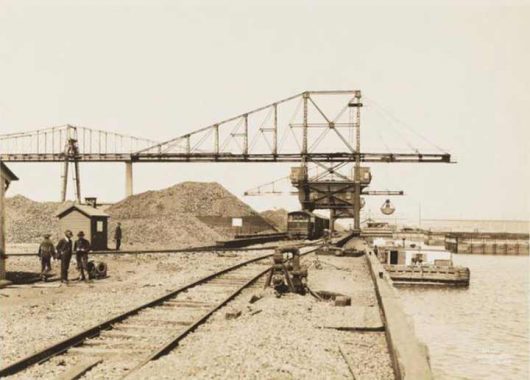
In the early 20th century, the East River had power plants at Vinegar Hill, 14th Street, 38th Street, Hunters Point, 74th Street, Ravenswood, Stony Point, and Lawrence Point. All had heating supplied by barges bringing coal from New England. For the largest power plant in the country, a system of train tracks transported coal from the docks to the furnaces, as seen in this photo from 1920.
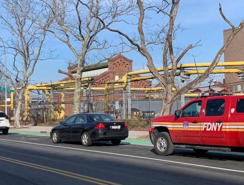
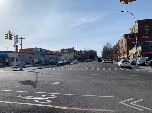
The only reminder of the railroad within the power plant is a scoop near the corner of Shore Road and 20th Avenue that rests on the water’s edge. When my alma mater, P.S. 139 in Rego Park retired its coal furnace in 1997, the school also placed its old scoop on the front lawn as a souvenir of a much more polluted past. The view here is looking north towards the power plant from Ralph DeMarco Park, the closest public access to Lawrence Point

From this spot looking south are the Hell Gate and Triboro (RFK) bridges. A lengthy freight train is crossing Hell Gate on a single track that runs alongside two tracks used by Amtrak, and hopefully soon, Metro North. For decades there has been the Triboro RX proposal for a passenger line linking the Bronx, Queens, and Brooklyn. But I can’t imagine an elevated subway line sharing tracks with freight trains.

These two bridges are not the only link between Astoria and the Bronx. A tunnel for gas mains connecting to a power plant at Stony Point was constructed in 1915. With a 21-foot diameter, perhaps it is wide enough for two lanes of traffic, or more imaginatively as a pedestrian or bike tunnel. But at 4,662 feet in length and more than 200 feet below the surface, this secret tunnel is not practical for public use.
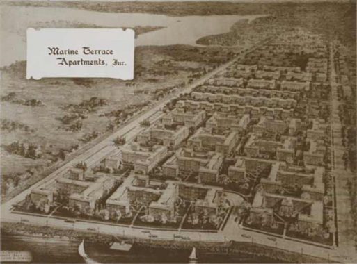
Across 20th Avenue from the power plant is a cluster of identical apartment buildings. Constructed in 1948 under the name Marine Terrace, it was a middle class development that is still relatively affordable as the largest set of section 8 apartments in Astoria. The prospectus for these homes shows empty land on the site of the plant. Buyer beware.
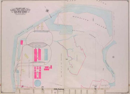
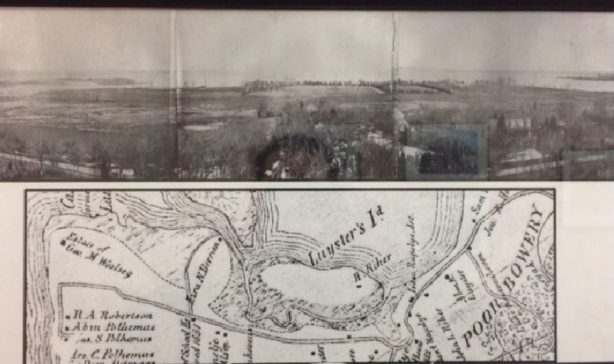
The Belcher-Hyde atlas of 1919 shows the train tracks of Lawrence Point running in loops on the property. Also noteworthy on this map is Berrian Creek which was being filled, fusing Berrian’s Island to the mainland. The “proposed canal” on the eastern edge is today’s Luyster Creek. On the bottom of the map, Old Bowery Road parallels 20th Avenue. Within the power plant this ancient road was eliminated, but there is a segment of it today that runs between 31st and 46th Streets under the name 20th Road.

Returning to that photo from 1920, it shows the train tracks at Lawrence Point and above them the world’s largest coal transfer bridge of that time. This power plant had many superlatives in its early decades. The tracks at Lawrence Point were not the shortest freight railroad in the city. That distinction went to Liberty Island, as documented by TrainWeb.

From the Museum of the City of New York, an aerial shot from 1925 shows most of the former farm with two massive gas holder tanks at 21st Street. At the time, they were the largest of their kind in the world with a capacity of 15,000,000 cubic feet. The cityscape had dozens of such tanks at the time but after the 1950s they were phased out. The last tanks of this kind, located in Greenpoint, were imploded in July 2001.

The site of Astoria’s two holder tanks is marked with two circular ponds that serve as an unintentional nature preserve akin to the Ridgewood Reservoir on the Brooklyn-Queens border. Can a former tank site be repurposed as a green space? Of course! That’s what happened in Elmhurst after its two tanks were demolished in 1996.

From the 21st Street gate looking towards the western pond, I cannot begin to imagine how much remediation would be needed to make this pond acceptable as a designated nature preserve.
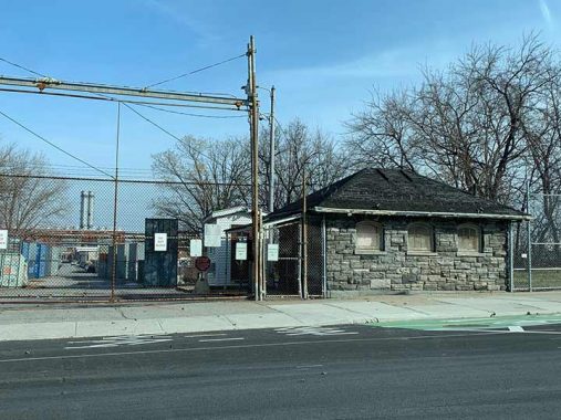
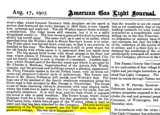
The site of these two holder tanks can be seen from the sky in the form of two circular ponds with 21st Street running between them. The entrance to the power plant here has a gatehouse made from locally sourced stones. I can’t say for sure whether this building predates the plant, but a report from 1903 published in the American Gas Light Journal notes a gatehouse and other structures on or near the property that belonged previously to some of Astoria’s leading families: Ditmars, Woolsey, Lawrence, and Polhemus.
These families descend from New York’s early Dutch and English settlers, bestowing their names to local streets, schools, playgrounds, cemeteries, and a subway station. The pedigree of the Woolsey family includes Cardinal Thomas Wolsey, who lived during the reign of Henry VIII and famously refused to annul his first marriage. Their first ancestor to settle in Queens was George Woolsey in 1647. Like the Pilgrims of Plymouth, he initially fled to the Netherlands and then to the New Netherlands in search of religious freedom.

In 1706, the Woolsey family built the Casina mansion on their farm, overlooking the tip where Hell Gate widens into the upper East River. The name is either a misspelling of casino, or inspired by a play of this name by early Roman playwright Plautus. In those days, the East River was recognized on maps as part of Long Island Sound and like the “Gold Coast” shoreline further east, the section flowing through Queens was lined with dozens of mansions into the mid-19th century.
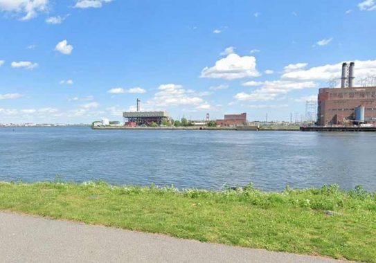
Looking at the same scene from across Hell Gate at Randalls Island’s Sunken Meadow fields, we see no traces of its bucolic past. Near the bend is the 500 megawatt steam turbine generator, and on the right is the power plant structure. On the evening of Dec. 27, 2018 a malfunction at a transformer at this plant resulted in a burst of blue light seen across the city, dubbed on social media as Astoria Borealis. It appeared supernatural but New Yorkers have seen it all.
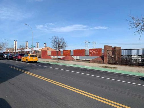
In a concession to the public, either Con Edison or the New York Power Authority ceded a tiny bit of land at 26th Street for a brick and concrete sitting area on the power plant’s border. It hardly looks inviting, but with murals or mosaics honoring the importance of the power plant, perhaps then this sitting area would be worth a visit. Astoria has plenty of artists and other creative professionals who can lend their talents to this spot.
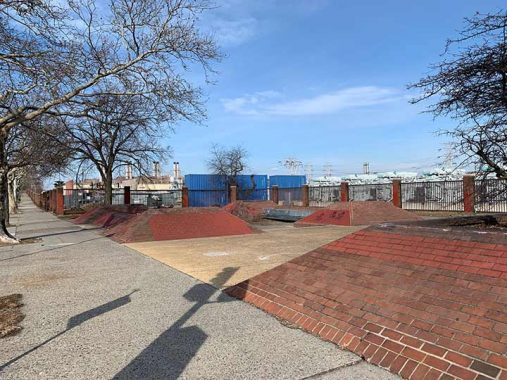
Next to the power plant’s main gate at 31st Street is a larger sitting area framed by sloping bricks. Aside from protesters, I have never seen it in use by the public. It vaguely reminds me of a skateboarding park.
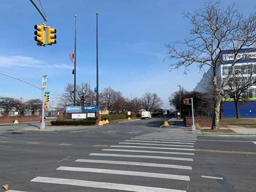
The main gate to the power plant is a continuation of 31st Street into the property. It lists the four operators of the site: Con Edison, New York Power Authority, NRG, and Astoria Generating Company. In smaller letters there is an official name for this site: Charles Poletti Power Project.
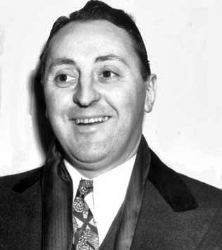
About the namesake: Poletti was a lifelong civil servant. He served as governor for 29 days in 1942, seemingly an asterisk in history. But Poletti was also a board member of the NAACP, state court justice, supervised racial integration in the military, spearheaded the transition in Sicily from fascism to democracy, and ran the New York Power Authority. So it was fitting that this site was named for him in 1982. He died two decades later, a year shy of the century mark. Not to diminish from the Cuomo dynasty, but Poletti’s very brief tenure makes him the state’s first Italian-American governor and he had a winning smile.
|
|
|
|
|
|
If 31st Street could continue north into the power plant to the water’s edge, it would be running atop the former Berrian’s Island. Its namesake family resided on it from the late 1600s through 1850. During that time, they had a tiny cemetery on this island that had been lost to history. When Berrian’s Island was sold to the Woolseys, city officials toured it as a potential potter’s field. In the end, Hart Island was chosen as the final destination for New York’s unclaimed dead.
The island and its creek were flattened by Con Ed in 1903 using soil from other spots on the giant property whose hills and valleys became as “flat as a billiard table,” in the words of Long Island City Star. On the right in the above view is Bowery Bay, which I documented in 2010. The image and map above are from the Greater Astoria Historical Society, a longtime partner of Forgotten-NY on local history projects.
Returning to the subway, the nearest station is the N terminal at Ditmars Boulevard. To get there from the main gate is to walk the only two blocks of 31st Street that have sunshine. In the 1990s, there was a proposal to extend the elevated N train to LaGuardia Airport, putting these two blocks in the shadow of the tracks. NIMBY opposition and Astoria’s powerful Council Speaker Peter Vallone Sr. killed the plan. Perhaps the extension will have another chance now that Andrew Cuomo’s “backward AirTrain” has been canceled.

The alternative history of the city can be gleaned from this 1891 map that shows a grid of paper streets on the site of the Astoria power plant, a neighborhood extension that was never built. At the top of this map is Berrians Island, named for a colonial family whose descendants owned it into the mid-19th century.
As points on the East River are concerned, Forgotten-NY has essays on Corlears Hook, Hunters Point, Lighthouse Point on Roosevelt Island, Hallets Point, Clason Point, College Point, Throgs Neck, and Fort Totten (the actual Willets Point). On the Hidden Waters Blog, you can also visit Stony Point, Ferry Point, and Chisholm Point.
Thanks to Bob Singleton of the Greater Astoria Historical Society for providing details on the history of Lawrence Point and Berrian’s Island.
Sergey Kadinsky is the author of Hidden Waters of New York City: A History and Guide to 101 Forgotten Lakes, Ponds, Creeks, and Streams in the Five Boroughs (2016, Countryman Press) and the webmaster of Hidden Waters Blog.
As always, “comment…as you see fit.” I earn a small payment when you click on any ad on the site.
1/23/22
9 comments
The Bronx end of the East River utility tunnel is the little brick building at 912 E 132nd street. I was watching one day when a very large crane was positioned in the street, the top of the building was opened, and the crane
pulled 100 foot lengths of pipe from an (apparently) 1 story building.
There is very little coal in New England. NYC was supplied with steam coal from Appalachian coal fields. Home heating coal came from the Scranton area.
Thank you. Very interesting story with many facts.
The ICYP field is also owned by Con Ed and has been leased out for a dollar a year or at least it was when I was in their little league program over 50 years ago. I’m amazed it hasn’t been developed yet.
As a published author on the topic of forgotten lakes, I’m surprised Mr Kadinsky would be denied access to have a look at the two ponds on the property. I would imagine their P.R. people might see it as an opportunity for some favorable publicity.
The two ‘ponds’ are the foundations for the two gas holders that were sited there. These tanks would float like a hollow piston on a water collar and move vertically inside the external steel frame. When the outside steel frame work was removed the holders (tanks) were lowered into the pits and rested on a wood timber support frame work. A contractor (Hill Wrecking) was hired to cut the steel shells and scrap the pieces. The circular foundations with wood frames removed were then to be repurposed as a wastewater treatment facility for Astoria and other ConEd facilities. At the time a barge first named the Clearwater was constructed to transport the untreated/treated wastewater to Astoria for processing. Due to a hissy fit by the late crooner / environmentalist Pete Segar who’s Hudson River sailing sloop also named Clearwater, the barge was renamed the Wastewater.
There are old articles about the tunnel. It flooded during construction with fatalities.
https://www.glaver.org/books/asce-astoria/index.shtml
The sitting area of the 1st photo looks like a building was cut in half
horizontally to make that placeThe openings in the walls are where
the windows were.
I really dig the old estate buildings being put to use by Con-Ed.
I used to occasionally find the remains of old estates around Great
Neck,Pt. Washington
I have a really interesting pic of a steam engine on this site, which was called Astoria Light Heat and Power at the time. The engine later went to the BEDT in Brooklyn. The
shot appears to be taken in the area of Luyster Creek. I don’t see how to attach it to this comment, but can send it to you if interested.
sure